
Books & Magazines

2024
Question 1
The longest border between any two countries in the world is between:
(a) Canada and the United States of America
(b) Chile and Argentina
(c) China and India
(d) Kazakhstan and Russian Federation
ExplanationAns: a
Exp:
Canada shares the longest international land border with the United States. The Canada-US land border is 8,893 km long. The border is divided into two: the border shared with Canada by the continental United States and the border that the state of Alaska shares with northern Canada. Eight Canadian provinces and thirteen American states run along the shared boundary.
Question 2
Consider the following statements:
1. The Red Sea receives very little precipitation in any form.
2. No water enters the Red Sea from rivers.
Which of the statements given above is/are correct?
(a) 1 only
(b) 2 only
(c) Both 1 and 2
(d) Neither 1 nor 2
ExplanationAns: c
Exp:
Red Sea is a narrow strip of water extending southeastward from Suez, Egypt, for about 1,200 miles (1,930 km) to the Bab el-Mandeb Strait, which connects with the Gulf of Aden and thence with the Arabian Sea.
Climate:
The Red Sea region receives very little precipitation in any form, although prehistoric artifacts indicate that there were periods with greater amounts of rainfall. Hence, statement 1 is correct.
Hydrology:
No water enters the Red Sea from rivers, and rainfall is scant, but the evaporation loss – in excess of 80 inches per year – is made up by an inflow through the eastern channel of the Bab el-Mandeb Strait from the Gulf of Aden. Hence, statement 2 is correct.
Question 3
Consider the following statements:
Statement-I: The atmosphere is heated more by incoming solar radiation than by terrestrial radiation.
Statement-II: Carbon dioxide and other greenhouse gases in the atmosphere are good absorbers of long wave radiation.
Which one of the following is correct in respect of the above statements?
(a) Both Statement-I and Statement-II are correct and Statement-II explains Statement-I
(b) Both Statement-I and Statement-II are correct but Statement-II does not explain Statement-I
(c) Statement-I is correct, but Statement-II is incorrect
(d) Statement-I is incorrect, but Statement-II is correct
ExplanationAns: d
Exp:
Statement-I is incorrect: Insolation reaches the earth’s surface in short waves and heat is radiated from the earth in long waves. The atmosphere is transparent to short waves and opaque to long waves. Hence, energy leaving the earth’s surface i.e. terrestrial radiation, heats up the atmosphere more than the incoming solar radiation i.e. insolation.
Statement-II is correct: The long-wave radiation is absorbed by atmospheric gases, particularly by carbon dioxide and other greenhouse gases. Thus, the atmosphere is indirectly heated by the Earth’s radiation.
Hence, statement-I is incorrect, but statement-II is correct.
Question 4
Consider the following statements:
Statement-I: Thickness of the troposphere at the equator is much greater as compared to poles.
Statement-II: At the equator, heat is transported to great heights by strong convectional currents.
Which one of the following is correct in respect of the above statements?
(a) Both Statement-I and Statement-II are correct and Statement-II explains Statement-I
(b) Both Statement-I and Statement-II are correct, but Statement-II does not explains Statement-I
(c) Statement-I is correct, but Statement-II is incorrect
(d) Statement-I is incorrect, but Statement-II is correct.
ExplanationAns: a
Exp:
The troposphere is the lowermost layer of the atmosphere. Its average height is 13 km and extends roughly to a height of 8 km near the poles and about 18 km at the equator. Hence, statement 1 is correct.
The thickness of the troposphere is greatest at the equator because heat is transported to great heights by strong convectional currents. This layer contains dust particles and water vapour. Hence, statement 2 is correct.
Changes in climate and weather take place in the troposphere. This includes changes in atmospheric concentration of various gases, temperature and humidity, etc.
Hence, both Statement-I and Statement-II are correct and Statement-II explains Statement-I.
Question 5
Consider the following:
1. Pyroclastic debris
2. Ash and dust
3. Nitrogen compounds
4 . Sulphur compounds
How many of the above are products of volcanic eruptions?
(a) Only one
(b) Only two
(c) Only three
(d) All four
ExplanationAns: d
Exp:
A volcano is a place where gases, ashes and/or molten rock material – lava – escape to the ground. A volcano is called an active volcano if the materials mentioned are being released or have been released in the recent past.
Statement 1 is correct: The mantle contains a weaker zone called the asthenosphere. From this, the molten rock materials find their way to the surface. The material in the upper mantle portion is called magma. Once it starts moving towards the crust or reaches the surface, it is called lava. The material that reaches the ground includes:
Question 6
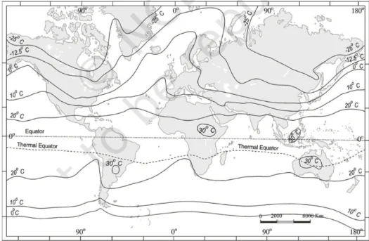
Which of the following is/are correct inference/inferences from isothermal maps in the month of January?
1. The isotherms deviate to the north over the ocean and to the south over the continent.
2. The presence of cold ocean currents, Gulf Stream and North Atlantic Drift make the North Atlantic Ocean colder and the isotherms bend towards the north.
Select the answer using the code given below:
(a) 1 only
(b) 2 only
(c) Both 1 and 2
(d) Neither 1 nor 2
Explanation
Ans: a Exp: Statement 1 is correct: In the northern hemisphere, the land surface area is much larger than in the southern hemisphere. Hence, the effects of land mass and ocean currents are well-pronounced. The isotherms deviate to the north over the ocean and to the south over the continent. The effect of the ocean is well pronounced in the southern hemisphere. Here, the isotherms are more or less parallel to the latitudes, and the variation in temperature is more gradual than in the northern hemisphere. Statement 2 is incorrect: North Atlantic Drift Current is part of a clockwise-setting ocean-current system in the North Atlantic Ocean, extending from southeast of the Grand Bank, off Newfoundland, Canada, to the Norwegian Sea, off northwestern Europe. It constitutes the northeastward extension of the Gulf Stream and is characterized by warm temperatures and high salinity.
Question 7
Which of the following countries are well known as the two largest cocoa producers in the world?
(a) Algeria and Morocco
(b) Botswana and Namibia
(c) Cote d’Ivoire and Ghana
(d) Madagascar and Mozambique
ExplanationAns: c
Exp:
Cocoa beans are produced in tropical zones around the Equator, where climate conditions are well suited for growing cocoa trees. About 70 percent of the world’s cocoa beans come from four West African countries: Ivory Coast, Ghana, Nigeria and Cameroon. The Ivory Coast (Cote d’Ivoire) and Ghana are by far the two largest producers of cocoa, accounting for more than 50 percent of the world´s cocoa. In 2021, the Ivory Coast alone produced approximately 2.1 million metric tons of cocoa beans.
Question 8
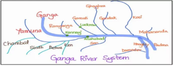
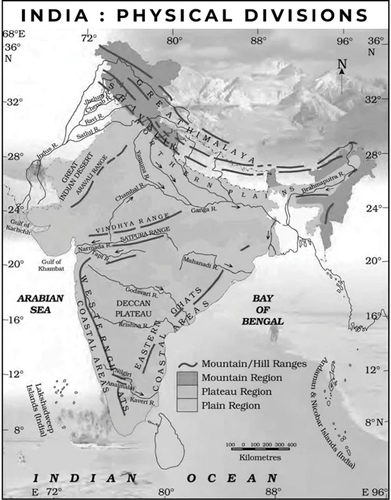
With reference to the Himalayan rivers joining the Ganga downstream of Prayagraj from West to East, which one of the following sequences is correct?
(a) Ghaghara – Gomati – Gandak – Kosi
(b) Gomati – Ghaghara – Gandak – Kosi
(c) Ghaghara – Gomati – Kosi – Gandak
(d) Gomati – Ghaghara – Kosi – Gandak
ExplanationAns: b
Exp:
Ganges River, rising in the Himalayas and emptying into the Bay of Bengal, drains one-fourth of the territory of India, and its basin supports hundreds of millions of people. The general direction of the river’s flow is from northwest to southeast. South of Haridwar, the river receives its principal right-bank tributary:
Yamuna River, which flows through the Delhi capital region and then roughly parallels the southeastward flow of the Ganges before joining it near Prayagraj (Allahabad).
The main left-bank tributaries of the Ganga are (from west to east- in the order of joining) :
Question 9
Consider the following statements:
Statement-I: Rainfall is one of the reasons for the weathering of rocks.
Statement-II: Rain water contains carbon dioxide in solution.
Statement-III: Rain water contains atmospheric oxygen.
Which one of the following is correct in respect of the above statements?
(a) Both Statement-II and Statement-III are correct and both of them explain Statement-I
(b) Both Statement-II and Statement-III are correct, but only one of them explains Statement-I
(c) Only one of the Statement II and III is correct and that explains Statement-I
(d) Neither Statement-II nor Statement-III is correct
ExplanationAns: a
Exp:
Chemical weathering describes the process of chemicals in rainwater making changes to the minerals in a rock. Hence, Statement I is correct.
Carbon dioxide from the air is dissolved in rainwater, making it slightly acidic. A reaction can occur when the rainwater comes into contact with minerals in the rock, causing weathering. Hence, Statement II is correct.
Oxidation: This is the process in which atmospheric oxygen reacts with the rock to produce oxides. The process is called oxidation. The greatest impact of this process is observed on ferrous minerals. Oxygen present in humid air/rainfall reacts with iron grains in the rocks to form a yellow or red oxide of iron. This is called rusting of the iron. Rust decomposes rocks completely with the passage of time. Hence, Statement III is correct.
Hence, both statement-II and statement-III are correct and both of them explain statement-I
Question 10
Consider the following countries
1. Finland
2. Germany
3. Norway
4. Russia
How many of the above countries have a border with the North Sea?
(a) Only one
(b) Only two
(c) Only three
(d) All four
ExplanationAns: b
Exp:
The North Sea is a shallow, northeastern arm of the Atlantic Ocean located between the British Isles and the mainland of northwestern Europe and covering an area of 220,000 square miles (570,000 square km). The sea is bordered by:

Question 11
Consider the following information:
| Waterfall | Region | River |
| Dhuandhar | Malwa | Narmada |
| Hundru | Chota Nagpur | Subarnarekha |
| Gersoppa | Western Ghats | Netravati |
In how many of the above rows is the given information correctly matched?
(a) Only one
(b) Only two
(c) All three
(d) None
ExplanationAns: a
Exp:
Dhuandhar Falls: in Jabalpur is on Narmada river. Jabalpur is one of the most important cities of Madhya Pradesh and is located at the center of the State. The city is situated in the ‘Mahakaushal’ region.
The Malwa region includes the Madhya Pradesh districts of Dewas, Dhar, Indore, Jhabua, Mandsaur, Neemuch, Rajgarh, Ratlam, Shajapur, Ujjain, and parts of Guna and Sehore, and the Rajasthan districts of Jhalawar and parts of Banswara and Chittorgarh (not Jabalpur). Hence, row 1 is incorrect.
Hundru Falls: in Ranchi [Chotanagpur Plateau] is created on the course of the Subarnarekha River, where is falls from a height of 320 feet creating the highest water falls of the state.Hence, row 2 is correct.
Gersoppa Falls: also known as Jog Falls, is a cataract of the Sharavati River in western Karnataka state (Western Ghats), southwestern India. Hence, row 3 is incorrect.
Question 12
Consider the following information:
| Region | Name of the mountain range | Type of mountain
|
| Central Asia | Vosges | Fold mountain |
| Europe | Alps | Block mountain |
| North America | Appalachians | Fold mountain |
| South America | Andes | Fold mountain |
In how many of the above rows is the given information correctly matched?
(a) Only one
(b) Only two
(c) Only three
(d) All four
ExplanationAns: b
Exp:
Row 1 is incorrect: Vosges is a mountain extending west of the Rhine River Valley in the Haut-Rhin, Bas-Rhin, and Vosges départements of eastern France.
Row 2 is incorrect: Alps is a small segment of a discontinuous mountain chain that stretches from the Atlas Mountains of North Africa across southern Europe and Asia to beyond the Himalayas. The Alps [Fold Mountains] extend north from the subtropical Mediterranean coast near Nice, France, to Lake Geneva before trending east-northeast to Vienna (at the Vienna Woods). There, they touch the Danube River and meld with the adjacent plain.
Row 3 is correct: The Appalachian Mountains [Fold Mountains] of the great highland system of North America are the eastern counterpart of the Rocky Mountains. Extending for almost 2,000 miles (3,200 km) from the Canadian province of Newfoundland and Labrador to central Alabama in the United States, the Appalachian Mountains form a natural barrier between the eastern Coastal Plain and the vast Interior Lowlands of North America.
Row 4 is correct: Andes Mountains is a fold mountain system of South America and one of the great natural features on Earth.
Question 13
Consider the following:
1. Cashew
2. Papaya
3. Red sanders
How many of the above trees are actually native to India?
(a) Only one
(b) Only two
(c) All three
(d) None
ExplanationAns: a
Exp:
Cashew: is an evergreen shrub or tree of the sumac family (Anacardiaceae), cultivated for its characteristically curved edible seeds, which are commonly called cashew “nuts” though they are not true nuts. The domesticated cashew tree is native to the New World but commercially cultivated mainly in Brazil and India. Hence, option 1 is incorrect.
Papaya: is a succulent fruit of a large plant of the family Caricaceae. Though its origin is rather obscure, the papaya may represent the fusion of two or more species of Carica native to Mexico and Central America. Today it is cultivated throughout the tropical world and into the warmest parts of the subtropics. Hence, option 2 is incorrect.
Red Sanders (Pterocarpus santalinus): is an endemic tree species of the forests of the Seshachalam, Veligonda, Lankamala and Palakona Hills range of Andhra Pradesh. Hence, option 3 is correct.
Question 14
With reference to “water vapour”, which of the following statements is/are correct?
1. It is a gas, the amount of which decreases with altitude.
2. Its percentage is maximum at the poles.
Select the answer using the code given below:
(a) 1 only
(b) 2 only
(c) Both 1 and 2
(d) Neither 1 nor 2
ExplanationAns: a
Exp:
Statement 1 is correct: Water vapour is also a variable gas in the atmosphere, which decreases with altitude. In the warm and wet tropics, it may account for four per cent of the air by volume, while in the dry and cold areas of deserts and polar regions, it may be less than one percent of the air.
Statement 2 is incorrect: Water vapour decreases from the equator towards the poles because insolation decreases as we move from the tropics to the poles, and due to this, evaporation also decreases, which results in the decrease of vapour in the atmosphere.
It also absorbs parts of the insolation from the sun and preserves the earth’s radiated heat. It, thus, acts like a blanket allowing the earth neither to become too cold nor too hot. Water vapour also contributes to the stability and instability of the atmosphere.
Question 15
Consider the following description:
Annual and daily range of temperatures is low.
Precipitation occurs throughout the year.
Precipitation varies between 50 cm – 250 cm.
What is this type of climate?
(a) Equatorial climate
(b) China type climate
(c) Humid subtropical climate
(d) Marine West coast climate
ExplanationAns: d
Exp:
Marine West Coast Climate (Cfb)
Marine west coast climate is located poleward from the Mediterranean climate on the west coast of the continents. The main areas are:
Due to marine influence, the temperature is moderate and in winter, it is warmer than for its latitude. The mean temperature in summer months ranges from 15°-20°C and in winter 4°-10°C. The annual and daily ranges of temperature are small. Precipitation occurs throughout the year. Precipitation varies greatly from 50-250cm.
Question 16
With reference to “Coriolis force”, which of the following statements is/are correct?
1. It increases with increase in wind velocity.
2. It is maximum at the poles and is absent at the equator.
Select the answer using the code given below:
(a) 1 only
(b) 2 only
(c) Both 1 and 2
(d) Neither 1 nor 2
ExplanationAns: c
Exp:
Coriolis force is at a right angle to wind direction and directly proportional to wind speed. That is, as wind speed increases, Coriolis force increases. At a given latitude, double the wind speed and you double the Coriolis force. Hence, statement 1 is correct.
Why at a given latitude?
Coriolis force varies with latitude from zero at the Equator to a maximum at the poles. It influences wind direction everywhere except immediately at the Equator; but the effects are more pronounced in middle and high latitudes. Hence, statement 2 is correct.
Question 17
On June 21 every year, which of the following latitude(s) experience(s) a sunlight of more than 12 hours?
1. Equator
2. Tropic of Cancer
3. Tropic of Capricorn
4. Arctic Circle
Select the correct answer using the code given below:
(a) 1 only
(b) 2 only
(c) 3 and 4
(d) 2 and 4
ExplanationAns: d
Exp:
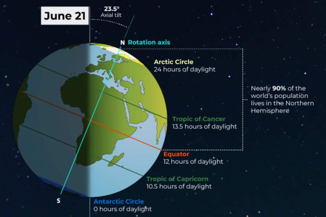
The figure above elucidates that all latitudes above equator experience more than 12 hrs of the sun-lit hours. Hence, Tropic of Cancer and Arctic Circle are correct.
Question 18
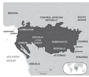
One of the following regions has the world’s largest tropical peatland, which holds about three years worth of global carbon emissions from fossil fuels; and the possible destruction of which can exert detrimental effect on the global climate.
Which one of the following denotes that region?
(a) Amazon Basin
(b) Congo Basin
(c) Kilkori Basin
(d) Rio de la Plata Basin
ExplanationAns: b
Exp:
The Congo Basin is home to the world’s largest tropical peatlands, along with Brazil and Indonesia. The peat swamp forest of the Congo Basin stores around 29 billion tons of carbon – approximately equivalent to three years’ worth of global greenhouse gas emissions – while the Basin as a whole absorbs nearly 1.5 billion tons of carbon dioxide a year. The Basin stretches across six countries- Cameroon, Central African Republic, Democratic Republic of the Congo, Congo, Equatorial Guinea and Gabon.
Peatlands cover only 3 per cent of the global land surface but store an estimated 600 billion tons of carbon- twice as much as in all the world’s forests. This makes them one of the most efficient carbon sink ecosystems and underlines the need to protect them, experts say.
Question 19
Consider the following plants:
1. Groundnut
2. Horse-gram
3. Soybean
How many of the above belong to the pea family?
(a) Only one
(b) Only two
(c) All three
(d) None
ExplanationAns: c
Exp:
Commonly known as the pea family, Fabaceae features about 670 genera and nearly 20,000 species of trees, shrubs, vines, and herbs. Distributed worldwide, members of the family are generally characterized by compound leaves and the production of fruits known as legumes. The following is a list of some of the major genera and species in Fabaceae:
Question 20
The total fertility rate in an economy is defined as:
(a) the number of children born per 1000 people in the population in a year.
(b) the number of children born to a couple in their lifetime in a given population.
(c) the birth rate minus death rate.
(d) the average number of live births a woman would have by the end of her child-bearing age.
ExplanationAns: d
Exp:
Total Fertility Rate (TFR) represents the number of children that would be born to a woman if she were to live to the end of her childbearing years and bear children in accordance with age-specific fertility rates of the specified year. A TFR of 2.1 is known as the replacement rate.
2023
Question 1
Consider the following statements:
1. Jhelum River passes through Wular Lake.
2. Krishna River directly feeds Kolleru Lake.
3. Meandering of the Gandak River formed Kanwar Lake.
How many of the statements given above are correct?
(a) Only one
(b) Only two
(c) All three
(d) None
ExplanationAns: b
Exp:
Statement 1 is correct: Wular Lake is the largest lake in the Jammu and Kashmir territory, in the northern part of the Indian subcontinent. It is located in Bandipora district in Jammu and Kashmir. The lake controls the flow of the Jhelum River.
Statement 2 is not correct: The Kolleru Lake is fed directly by water from the seasonal Budameru and Tammileru streams and not the Krishna River. It is connected to the Krishna and Godavari systems by over 68 inflowing drains and channels. Kolleru Bird Sanctuary serves as a habitat for migratory birds.
Statement 3 is correct: Kanwar jheel/ Kabar Taal, as it is locally called, is located 22 km northwest of Begusarai town. It is a freshwater residual oxbow lake formed due to the meandering of Gandak River, a tributary of Ganga, in the geological past. Kanwar Lake was declared a notified area under the Wildlife (Protection) Act of 1972. To check the poaching of birds, it was declared a protected zone by the Bihar state government in 1986; the government of India declared it a bird sanctuary in 1989.
Question 2
Consider the following pairs:
Port Well known as
1. Kamarajar Port : First major port in India registered as a company
2. Mundra Port : Largest privately owned port in India
3. Visakhapatnam : Largest container port in India
How many of the above pairs are correctly matched?
(a) Only one pair
(b) Only two pairs
(c) All three pairs
(d) None of the pairs
Ans: b
Exp:
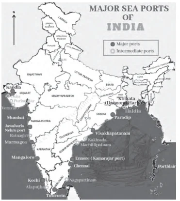
Pair 1 is correctly matched: The Kamarajar Port, located on the Coromandel Coast about 24 km north of Chennai Port, Chennai. The port was declared a major port under the Indian Ports Act 1908 in March 1999 and incorporated as Ennore Port Limited under the Companies Act 1956 in October 1999. It is the only corporatised major port and the first port in India which was registered as a public company.
Pair 2 is correctly matched: Mundra Port is situated along the northern coast of the Gulf of Kutch near Mundra in the Kutch district of Gujarat. It is the largest privately owned port of India. In 2003, it was designated as a Special Economic Zone (SEZ), making it the largest private SEZ in the country. It is known to be an all-weather port.
Pair 3 is not correctly matched: Visakhapatnam Port ranks as India’s third largest state-owned port in terms of cargo volume handled and holds the distinction of being the largest port on the Eastern Coast. Positioned between the Chennai and Kolkata Ports along the Bay of Bengal, it serves as a strategic midpoint. Jawaharlal Nehru Port (Nhava Sheva) is the largest container port in India.
Question 3
Consider the following trees:
1. Jackfruit (Artocarpus heterophyllus)
2. Mahua (Madhuca indica)
3. Teak (Tectona grandis)
How many of the above are deciduous trees?
(a) Only one
(b) Only two
(c) All three
(d) None
ExplanationAns: b
Exp:
Option 1 is not correct: Jackfruit (Artocarpus heterophyllus) is a tropical evergreen tree that grows up to 20 m in height.
Option 2 is correct: Mahua (Madhuca indica is a deciduous tree that grows up to 20 m tall.
Option 3 is correct: Teak (Tectona grandis) is a deciduous tree. Teakwood forests are predominantly found in Northeast India.
Question 4
Consider the following statements:
1. India has more arable area than China.
2. The proportion of irrigated area is more in India as compared to China.
3. The average productivity per hectare in Indian agriculture is higher than that in China.
How many of the above statements are correct?
(a) Only one
(b) Only two
(c) All three
(d) None
ExplanationAns: b
Exp:
Statement 1 is correct: India has more arable area than China. As per the 2019 data, the top 10 countries with the
most arable land in the world are as follows:
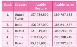
Statement 2 is correct: China’s irrigation cover is 41% of the cultivated area, and that of India is 48%.
Statement 3 is not correct: The average productivity per hectare is higher in China compared to that of India.
Question 5
Which one of the following is the best example of repeated falls in sea level, giving rise to present-day extensive marshland?
(a) Bhitarkanika Mangroves
(b) Marakkanam Salt Pans
(c) Naupada Swamp
(d) Rann of Kutch
Ans: d
Exp:
Option 1 is incorrect: Bhitarkanika mangroves, situated in Odisha, India, represent a noteworthy mangrove ecosystem. Although subject to tidal variations, it has not been created as a result of recurrent decline in sea level. Instead, it has been shaped by the riverine system and recognised as a crucial breeding habitat for diverse species, including
the endangered saltwater crocodile.
Option 2 is incorrect: Marakkanam salt pans, located in Tamil Nadu, are coastal salt marshes utilised for salt production. These pans form in coastal low-lying areas where seawater evaporates, depositing salt crystals. However, it’s essential to note that these salt pans are not a consequence of recurring decline in sea level; rather, these have been established by harnessing existing seawater resources.
Option 3 is incorrect: Naupada Swamp, alternatively referred to as Naupada Wetland, is situated in Andhra Pradesh. Recurrent decreases in sea level have not shaped this freshwater swamp. Rather, it has been created by the influx of freshwater from rivers and seasonal precipitation.
Option 4 is correct: The Great Rann of Kachchh comprises a unique geomorphic entity of the Indian subcontinent. It is a mysterious and fascinating tectonic landscape in an area marked by sea- level changes. Once a shallow extension of the Arabian Sea, the Rann underwent a geological transformation when a shift occurred, disconnecting it from the sea. Over time, this area evolved into a seasonal marshy salt desert. During the monsoon season, it becomes inundated with water, transforming into a wetland. In the summer months, the water recedes, leaving behind a white, salty land bed.
Question 6
Ilmenite and rutile, abundantly available in certain coastal tracts of India, are rich sources of which one of the following?
(a) Aluminium
(b) Copper
(c) Iron
(d) Titanium
ExplanationAns: d
Exp:
Ilmenite (FeTiO3 / FeO.TiO2) and rutile are the most commonly found and abundant minerals of titanium. Ilmenite is weakly magnetic mineral sand, grey-black in colour, solid in form and exists in a triangle crystal structure. Rutile is the most abundant of three naturally occurring forms of titanium dioxide (TiO2; other two forms – anatase; and brookite). It
is reddish-brown and exists in a tetragonal crystal structure. Ilmenite and rutile, being titanium oxide minerals, are used to produce high-performance metal parts such as artificial human body parts, aircraft engine parts, sporting equipment, synthetic rutile, pigments, etc. These pigments are used for whitening in papers, paints, toothpaste, adhesives, plastic and foods and nanotechnologies. India possesses substantial reserves of heavy minerals primarily located along its coastal regions and inland placers. Heavy mineral sands consist of a group of seven minerals: ilmenite, leucoxene (brown ilmenite), rutile, zircon, sillimanite, garnet, and monazite.
Question 7
About three-fourths of the world’s cobalt, a metal required for the manufacture of batteries for electric motor vehicles, is produced by
(a) Argentina
(b) Botswana
(c) The Democratic Republic of the Congo
(d) Kazakhstan
Which one of the following is a part of the Congo Basin?
(a) Cameroon
(b) Nigeria
(c) South Sudan
(d) Uganda
ExplanationAns: c
Exp:
Cobalt is a crucial component in producing batteries for electric vehicles, in addition to being indispensable in various electronic devices like smartphones and laptops.
Top Cobalt Producing Countries: The Democratic Republic of the Congo: This is by far the world’s largest producer of cobalt, accounting for roughly 70 percent of global production. The Democratic Republic of Congo is followed by Indonesia, Russia, Australia and Canada in Cobalt production. In India, Cobalt is primarily concentrated in the state of Odisha. Nevertheless, Cobalt production is currently nonexistent in the country.
Question 8
Consider the following statements:
1. Amarkantak Hills are at the confluence of the Vindhya and Sahyadri Ranges.
2. Biligirirangan Hills constitute the easternmost part of the Satpura Range.
3. Seshachalam Hills constitute the southernmost part of the Western Ghats.
How many of the statements given above are correct?
(a) Only one
(b) Only two
(c) All three
(d) None
ExplanationAns: a
Exp:
Congo basin is the basin of the Congo River, lying astride the Equator in west-central Africa. It is the world’s second-largest river basin (next to that of the Amazon), comprising an area of more than 1.3 million square miles (3.4 million square km). The vast drainage area of the Congo River includes almost the whole of the Republic of the Congo, the Democratic Republic of the Congo, the Central African Republic, western Zambia, northern Angola, and parts of Cameroon and Tanzania. This not only is vast but is also covered with a dense and ramified network of tributaries, sub-tributaries, and small rivers – with the exception of the sandy plateaus in the southwest.
The rainforest within the Congo Basin stands as Africa’s largest rainforest, ranking second only to the Amazon rainforest in terms of size.
Question 9
With reference to India’s projects on connectivity, consider the following statements:
1. East-West Corridor under Golden Quadrilateral Project connects Dibrugarh and Surat.
2. The Trilateral Highway connects Moreh in Manipur and Chiang Mai in Thailand via Myanmar.
3. Bangladesh-China-India-Myanmar Economic Corridor connects Varanasi in Uttar Pradesh with Kunming in China.
How many of the above statements are correct?
(a) Only one
(b) Only two
(c) All three
(d) None
ExplanationAns: d
Exp:
Statement 1 is not correct: Amarkantak is situated in Anuppur district of the state of Madhya Pradesh at the meeting place of the Vindhya and Satpura mountain ranges. It is known to be the origin of the Narmada River, Mahanadi, and Son Rivers.
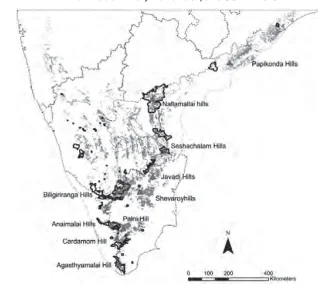
Statement 2 is not correct: Biligirirangan Hills belong to the Eastern Ghats mountain range rather than the Satpura Range. The Biligirirangan Hills are renowned for harbouring a substantial population of Asian elephants.
Statement 3 is not correct: The Seshachalam hills are a part of the Eastern Ghats in the Andhra Pradesh state of India. The hills are also known as Venkatachalam.
Question 10
Consider the following statements:
Statement-I: Switzerland is one of the leading exporters of gold in terms of value.
Statement-II: Switzerland has the second largest gold reserves in the world.
Which one of the following is correct in respect of the above statements?
(a) Both Statement-I and Statement-II are correct and Statement-II is the correct explanation for Statement-I
(b) Both Statement-I and Statement-II are correct and Statement-II is not the correct explanation for Statement-I
(c) Statement-I is correct but Statement-II is incorrect
(d) Statement-I is incorrect but Statement-II is correct
Ans: d
Exp:
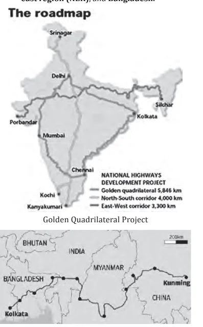
Statement 1 is not correct: The Golden Quadrilateral Project is a significant highway development initiative in India designed to link the four major metropolitan cities: Delhi, Mumbai, Chennai, and Kolkata. As part of this project, the East-West Corridor connects Silchar in Assam to Porbandar in Gujarat.
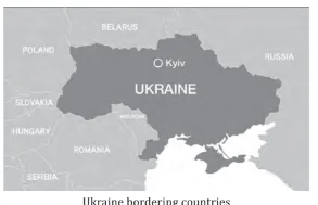
Statement 2 is not correct: The Trilateral highway (IMT), which was initially conceptualised some 15 years ago, connects India’s Moreh in the northeast of the country to Mae Sot in Thailand, via Myanmar.
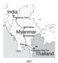
Statement 3 is not correct: The proposed Bangladesh-China-India-Myanmar Economic Corridor (BCIM) aims to boost economic cooperation and trade among Bangladesh, China,
India, and Myanmar through enhanced connectivity. It stretches from southwest China to eastern India (‘Kunming to Kolkata’) via Myanmar, India’s north east region (NER), and Bangladesh.
Question 11
Consider the following countries:
1. Bulgaria
2. Czech Republic
3. Hungary
4. Latvia
5. Lithuania
6. Romania
How many of the above-mentioned countries share a land
border with Ukraine?
(a) Only two
(b) Only three
(c) Only four
(d) Only five
ExplanationAns: c
Exp:
Statement – I is correct: The top 5 countries that exported the highest dollar value worth of gold during 2021: Switzerland> United Kingdom> Hong Kong> United Arab Emirates> United States
Statement II is not correct: Top Countries with the Largest Gold Mine Reserves: Australia> Russia> South Africa> USA> Indonesia Hence, statement-I is correct but, statement-II is incorrect.
Question 12
With reference to the Earth’s atmosphere, which one of the following statements is correct?
(a) The total amount of insolation received at the equator is roughly about 10 times of that received at the poles.
(b) Infrared rays constitute roughly two-thirds of insolation.
(c) Infrared waves are largely absorbed by water vapour that is concentrated in the lower atmosphere
(d) Infrared waves are a part of the visible spectrum of electromagnetic waves of solar radiation.
Ans: a
Exp:
Ukraine is a country located in eastern Europe, the second largest on the continent after Russia. The capital is Kyiv, located on the Dnieper River in north-
central Ukraine. Ukraine is bordered by Belarus to the north, Russia to the east, the Sea of Azov and the Black Sea to the south, Moldova and Romania to the southwest, and Hungary, Slovakia, and Poland to the west.
Question 13
Consider the following statements:
Statement-I: The soil in tropical rain forests is rich in nutrients.
Statement-II: The high temperature and moisture of tropical rain forests cause dead organic matter in the soil to decompose quickly.
Which one of the following is correct in respect of the above statements?
(a) Both Statement-I and Statement-II are correct and Statement-II is the correct explanation for Statement-I
(b) Both Statement-I and Statement-II are correct and Statement-II is not the correct explanation for Statement-I
(c) Statement-I is correct but Statement-II is incorrect
(d) Statement-I is incorrect but Statement-II is correct
Ans: c
Exp:
The Earth’s surface predominantly receives its energy in the form of short wavelengths. Short-wave solar radiation largely passes through the atmosphere without significant obstruction. The atmosphere gets heated up through the absorption of long wave radiations emitted by the earth’s surface. Water vapour acts as a strong absorber of infrared radiation. In the lower atmosphere, where water vapour concentration is relatively higher, it absorbs a notable portion of the infrared radiation emitted by the Earth’s surface.
Option (a) is not correct: Though it is accurate that the equator receives greater direct sunlight in comparison to the poles, the disparity in insolation is not as substantial as tenfold. The variance in insolation between the equator and poles predominantly arises from the curvature of the Earth and the inclination of its axis, causing sunlight to strike different latitudes at varying angles.
Option (b) is not correct: Insolation denotes the entirety of solar radiation reaching the Earth’s surface, encompassing a wide range of electromagnetic radiation. Although infrared radiation constitutes a substantial portion of solar radiation, it does not represent two-thirds of the insolation. Insolation comprises visible light, ultraviolet (UV) radiation, and various other wavelengths alongside infrared radiation.
Option (d) is not correct: IR is not part of the visible range. infrared radiation has wavelengths longer than those of visible light and is not perceptible to the human eye.
Question 14
Consider the following statements:
Statement-I: The temperature contrast between continents and oceans is greater during summer than in winter.
Statement-II: The specific heat of water is more than that of land surface.
Which one of the following is correct in respect of the above statements?
(a) Both Statement-I and Statement-II are correct and Statement-II is the correct explanation for Statement-I
(b) Both Statement-I and Statement-II are correct and Statement-II is not the correct explanation for Statement-I
(c) Statement-I is correct but Statement-II is incorrect
(d) Statement-I is incorrect but Statement-II is correct
Ans: d
Exp:
Statement-I is not correct: The tropical rainforest occurs near the equator and close to the tropics. Thus it receives heavy rainfall throughout the year. The heavy rain causes intense leaching of the soil which increases the acidity of the soil. Due to increased acidity, there is an issue of less nutrient absorption from the soil.
Statement-II is correct: As the tropical rainforest lies in a region of heavy rainfall and near to tropics, thus the climate here is hot and humid. This causes the rapid decomposition of the dead organic material present in the soil.
Hence, statement-I is incorrect, but statement-II is correct.
Question 15
Consider the following statements:
1. In a seismograph, P waves are recorded earlier than S waves.
2. In P waves, the individual particles vibrate to and fro in the direction of wave propagation, whereas in S waves, the particles vibrate up and down at right angles to the
direction of wave propagation.
Which of the statements given above is/are correct?
(a) 1 only
(b) 2 only
(c) Both 1 and 2
(d) Neither 1 nor 2
Ans: a
Exp:
During the summer the temperature on land increases rapidly and in the ocean increases gradually, while in winter the temperature on land falls rapidly while in the oceans it decreases slowly. However the effect is typically less pronounced than the contrast seen in summer due to the overall lower temperatures.
Statement-I is correct: During summer, the temperature disparity between continents and oceans is more pronounced compared to winter.
Statement-II is correct: Specific heat is the amount of heat energy it takes to raise or lower the temperature of 1 gram of a substance by 1°Celsius. The specific heat of water is greater than that of dry soil, thus, water absorbs and releases heat more slowly than land.
Hence, Both statement-I and statement-II are correct and Statement-II is the correct explanation for Statement-I
Question 16
With reference to coal-based thermal power plants in India, consider the following statements:
1. None of them uses seawater.
2. None of them is set up in water-stressed district
3. None of them is privately owned.
How many of the above statements are correct?
(a) Only one
(b) Only two
(c) All three
(d) None
ExplanationAns: d
Exp:
Statement 1 is not correct: The usage of water in the thermal plant is crucial for cooling high temperatures and powering turbines with steam. In India, largely river water is used for this purpose; however, some of the thermal power plant e.g.- Mundra Thermal Power Station (Gujarat) uses seawater.
Statement 2 is not correct: More than a third of India’s freshwater-dependent plants are located in areas of high or extremely high water stress. These plants have, on average, a 21 percent lower utilisation rate than their counterparts located in low or medium water-stress regions – lack of water simply prevents them from running at full capacity.
Statement 3 is not correct: In India, thermal power plants are operated by both the private and public
2022
Question 1
In the northern hemisphere, the longest day of the year normally occurs in the:
(a) First half of the month of June
(b) Second half of the month of June
(c) First half of the month of July
(d) Second half of the month of July
ExplanationAns: b
Sub-Theme: Motion of Earth
Summer Solstice (21st June):
| NOTE: This question is a repetition from 2019 only the sentences of both the question and options are twisted to confuse the candidate. Also UPSC has asked questions from similar themes in 2013, please refer to the PYQs for detailed explanation. |
Question 2
Consider the following statements:
1. High clouds primarily reflect solar radiation and cool the surface of the Earth.
2. Low clouds have a high absorption of infrared radiation emanating from the Earth’s surface and thus cause a warming effect.
Which of the statements given above is/are correct?
(a) 1 only
(b) 2 only
(c) Both 1 and 2
(d) Neither 1 nor 2
ExplanationAns: d
Sub-Theme: Clouds
Statement 1 is incorrect: Low, thick clouds primarily reflect solar radiation and cool the surface of the Earth.
Statement 2 is incorrect: High, thin clouds primarily transmit incoming solar radiation. At the same time, they trap some of the outgoing infrared radiation emitted by the Earth and radiate it back downward, thereby warming the surface of the Earth.
Question 3
Consider the following States:
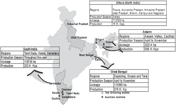
How many of the above are generally known as tea- producing States?
(a) Only one State
(b) Only two States
(c) Only three States
(d) All four States
ExplanationAns: c
Sub-Theme: Tea production
Tea Climatic conditions:
Question 4
With reference to India, consider the following statements:
Which of the statements given above are correct?
(a) 1, 2 and 3 only
(b) 1, 2 and 4 only
(c) 3 and 4 only
(d) 1, 2, 3 and 4
ExplanationAns: b
Sub-Theme: Rare Earth Metal
Statement 1 and 2 are correct: Rare earth metals are a group of 17 elements. They are lustrous silvery-white soft heavy metals. China accounts for 90% of the world’s rare earth production. In India, monazite is the principal source of rare earths and thorium.
Statement 3 is incorrect: Monazite, though found in most coastal areas of India, is unlikely to be found along the entire coast. The main mines are found along the coasts of southern India in Kerala, Tamil Nadu and in Orissa.
Statement 4 is correct: As per Atomic Energy (Radiation Protection) Rules 2004, Indian Rare Earths Limited (IREL), a wholly owned Public Sector Undertaking of the Government of India (GOI) under DAE, is the only entity which has been permitted to produce and process monazite, and handle it for domestic use as well as for export.
| NOTE: In the question, in statement 3, the extreme word ‘entire’ is a red flag. |
Question 5
Gandikota canyon of South India was created by which one of the following rivers?
(a) Cauvery
(b) Manjira
(c) Pennar
(d) Tungabhadra
ExplanationAns: c
Sub-Theme: Physical features of India
Question 6
Consider the following pairs:
| Peak | Mountains |
| 1. Namcha Barwa | Garhwal Himalaya |
| 2. Nanda Devi | Kumaon Himalaya |
| 3. Nokrek | Sikkim Himalaya |
Which of the pairs given above is/are correctly matched?
(a) 1 and 2
(b) 2 only
(c) 1 and 3
(d) 3 only
ExplanationAns: b
Sub-Theme: Physical features of India
Pair 1 is incorrect: Namcha Barwa is not situated in Garhwal Himalaya. It is situated in the Eastern Himalaya.
Pair 2 is correct: The part of the Himalayas lying between Satluj and Kali rivers is known as Kumaon Himalayas. Nanda Devi is part of the Kumaon Himalayas, and is located in the state of Uttarakhand, between the Rishi Ganga valley on the west and the Goriganga valley on the east.
Pair 3 is incorrect: Nokrek is situated in West Garo Hills of Meghalaya, not in Sikkim Himalaya.
Question 7
Consider the following pairs:
| Reservoirs | States |
| 1. Ghataprabha | Telangana |
| 2. Gandhi Sagar | Madhya Pradesh |
| 3. Indira Sagar | Andhra Pradesh |
| 4. Maithon | Chhattisgarh |
How many pairs given above are not correctly matched?
(a) Only one pair
(b) Only two pairs
(c) Only three pairs
(d) All four pairs
ExplanationAns: c
Sub-Theme: Reservoir and their location
Pair 1 is incorrect: The Ghataprabha Reservoir is located in the Belagavi district of the state of Karnataka.
Pair 2 is correct: The Gandhi Sagar Dam is one of the four major dams built on India’s Chambal River located in the Mandsaur, districts of the state of Madhya Pradesh.
Pair 3 is incorrect: The Indira Sagar Dam is the largest dam in India, in terms of volume of water stored in the reservoir. It is located on the Narmada River at the town of Narmada Nagar, Punasa in the Khandwa district of Madhya Pradesh in India.
Pair 4 is incorrect: The Maithon Dam is constructed on the Barakar River and it is located at Maithon, 48 km from Dhanbad, in the state of Jharkhand in India.
2021
Question 1
Consider the following statements
Which of the statements given above is/are correct?
(a) 1 only
(b) 2 only
(c) Both 1 and 2
(d) Neither 1 nor 2
ExplanationAns: c
Sub-Theme: Wind Movement
Statement 1 is correct: The Trade winds originate from subtropical high pressure regions and move toward the equatorial low pressure belt. At the equator, the trade winds from the two hemispheres collide, rising and bringing torrential rainfall. The Northeast trade winds in the Northern hemisphere of the tropical zone move warmer water westward through the ocean. As a result of the cool ocean currents, the eastern regions of the trade winds are drier and more stable than the western parts of the ocean.
Statement 2 is correct: The westerlies are the winds blowing from the subtropical high pressure belts towards the sub polar low pressure belts.The Westerlies play an important role in carrying the warm, equatorial waters and winds to the western coasts of continents that is eastern section of the Oceans in the temperate zone.
Question 2
“Leaf litter decomposes faster than in any other biome and as a result the soil surface is often almost bare. Apart from trees, the vegetation is largely composed of plant forms that reach up into the canopy vicariously, by climbing the trees or growing as epiphytes, rooted on the upper branches of trees.”
This is the most likely description of
(a) Coniferous forest
(b) Dry deciduous forest
(c) Mangrove forest
(d) Tropical rainforest
ExplanationAns: d
Sub-Theme: Major Climate of the World
Hot, Wet Equatorial Climate:
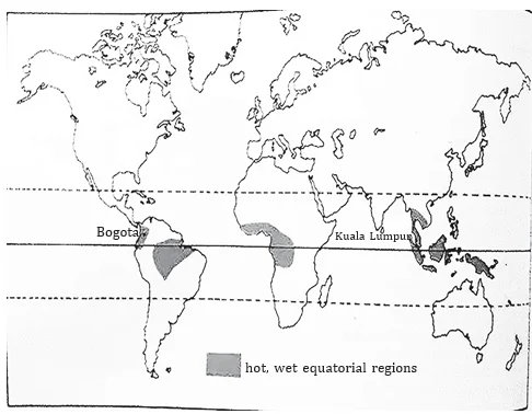
NOTE: UPSC has this habit of picking lines from GC Leong and frame it as a question. Please learn to pick the hints from the UPSC question, here in the above sentence observe the keywords like ‘Leaf litter decomposes faster’; ‘canopy’; ‘epiphytes’; etc. these are enough/sufficient hints to answer this question. Now if you have read NCERTs and GC Leong you could easily identify that these are the characteristics of ‘Tropical Rainforest’ or ‘Hot, Wet Equatorial Climate’.
Question 3
The black cotton soil of India has been formed due to the weathering of:
(a) Brown forest soil
(b) Fissure volcanic rock
(c) Granite and schist
(d) Shale and limestone
ExplanationAns: b
Sub-Theme: Type of Soil
Option (b) is correct: The black cotton soils of India have been formed due to the weathering of the fissure volcanic rock.
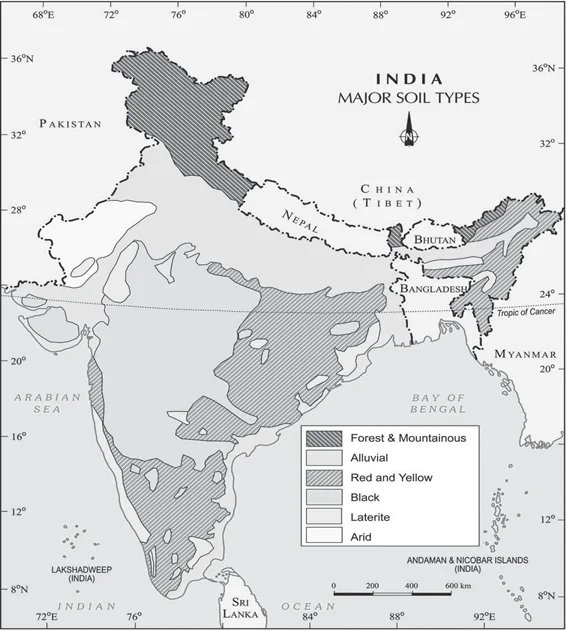
Major Soils Types
Question 4
Among the following, which one is the least water- efficient crop?
(a) Sugarcane
(b) Sunflower
(c) Pearl millet
(d) Red gram
ExplanationAns: a
Sub-Theme: Water efficient crop
Option (a) is correct: Sugarcane requires around 1800 to 2200 mm and basically it is a heavy water intensive crop.
Option (b) is incorrect: Major oilseeds like soyabean, castor seeds, cotton seeds, linseed and sunflower, etc. requires around 672.4 mm.
Option (c) is incorrect: Millets can be grown even in dry regions without irrigation facilities. Pearl millets require around 350 mm of water.
Option (d) is incorrect: Pulses like red gram require around 200-450 mm of water.
Question 5
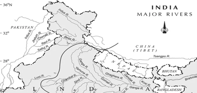
With reference to the Indus River system, of the following four rivers, three of them pour into one of them which joins the Indus directly. Among the following, which one is such a river that joins the Indus directly?
Chenab
(b) Jhelum
(c) Ravi
(d) Sutlej
ExplanationAns: d
Sub-Theme: Indus River System/Drainage
Option (a) is incorrect: The Chenab joins the Satluj in Panchnad(Pakistan) after receiving the waters of the Jhelum and Ravi rivers.
Option (b) is incorrect: The Jhelum joins the Chenab near Jhang in Pakistan.
Option (c) is incorrect: The Ravi debouches into the Chenab near Sarai Sidhu, a little above Rangpur in Pakistani Punjab.
Option (d) is correct: The Satluj receives the collective drainage of the Ravi, Chenab and Jhelum rivers. It joins the Indus a few kilometers above Mithankot.
Question 6
With reference to India, Didwana, Kuchaman, Sargol and Khatu are the names of
(a) Glaciers
(b) Mangrove areas
(c) Ramsar sites
(d) Saline lakes
ExplanationAns: d
Sub-Theme: Physiography of India
About Playas (Salt Lake):
Question 7
Consider the following rivers:
Which of the above rise from the Eastern Ghats?
(a) 1 and 2
(b) 2 and 4
(c) 3 and 4
(d) 1 and 3
ExplanationAns: b
Sub-Theme: Peninsular Drainage (Small East Flowing Rivers)
Statement 1 is incorrect: The Brahmani river comes into existence by the confluence of the Koel and the Shankh rivers near Rourkela.
Statement 2 is correct: Nagavali River originates in Kalahandi District, in the Eastern Ghats.
Statement 3 is incorrect: The Subarnarekha originates from the Ranchi Plateau in Jharkhand forming the boundary between West Bengal and Odisha in its lower course.
Statement 4 is correct: It is an east-flowing river that originates in the Kalahandi district of Odisha, Eastern Ghat, flows in Odisha, along its boundary with Andhra Pradesh and finally joins the Bay of Bengal at Kalingapatnam, Andhra Pradesh.
2020
Question 1
Consider the following statements
Which of the statements given above is/are correct?
(a) 1 only
(b) 2 and 3 only
(c) 2 only
(d) 1 and 3 only
ExplanationAns: c
Sub-Theme: Wind Movement
Jet Stream:
Statement 1 is not correct: In both the hemispheres, jet streams run from 20 degrees latitude to the poles.
Statement 2 is correct: Only some cyclones develop an eye. The eye is not present in a temperate cyclone since there is not a single location where the winds and precipitation are not present.
Statement 3 is not correct: The tropical cyclone’s eye is the area with the lowest surface pressure and the warmest air above it (in the upper levels). The eye temperature may be 10°C or more above the surrounding air at a height of 12 km, whereas it is only 0–2°C warmer at the surface.
Question 2
With reference to Ocean Mean Temperature (OMT), which of the following statements is/are correct?
Select the correct using the code given below:
(a) 1 only
(b) 2 only
(c) Both 1 and 2
(d) Neither 1 nor 2
ExplanationAns: b
Sub-Theme: Oceanography
About Ocean Mean Temperature (OMT):
Statement 1 is incorrect: OMT is measured up to a depth of 26°C isotherm at depths varying from 50-100 meters not 129 meters
Statement 2 is correct: OMC is analyzed by measuring the ocean thermal energy during the January-March period – can better predict Indian summer monsoon than the SST.
Question 3
Consider the following minerals:
In India, which of the above is/are officially designated as major minerals?
(a) 1 and 2 only
(b) 4 only
(c) 1 and 3 only
(d) 2, 3 and 4 only
ExplanationAns: d
Sub-Theme: Major Minerals in India
Question 4
“The crop is subtropical in nature. A hard frost is injurious to It requires at least 210 frost-free days and 50 to 100 centimeters of rainfall for its growth. A light well-drained soil capable of retaining moisture is ideally suited for the cultivation of the crop.”
Which one of the following is that crop?
(a) Cotton
(b) Jute
(c) Sugarcane
(d) Tea
ExplanationAns: a
Sub-Theme: Major Crop
Cotton:
NOTE: Learn to pick keywords/keyphrases from these long sentences to reach the correct answer. Here the keywords are – ‘subtropical’; ‘210 frost-free days’; ‘50 to 100 centimeters of rainfall’; ‘well- drained soil’. These keywords/keyphrases are enough to mark the correct answer. Also, this underlines the importance of reading NCERTs. UPSC asks questions on various crop/crops and their characteristics every alternate year. It is advisable to read India People and Economy class XII NCERT thoroughly.
Question 5
Which of the following Protected Areas are located in Cauvery basin?
Select the correct answer using the code given below:
(a) 1 and 2 only
(b) 3 and 4 only
(c) 1, 3 and 4 only
(d) 1, 2, 3 and 4
ExplanationAns: c
Sub-Theme: Major Places and Rivers/Map based
Option 1 is correct: The Nagarahole River flows through the park, which joins the Kabini River which also is a boundary between Nagarahole and Bandipur National Park. Kabini, a tributary of the Cauvery River, is the largest river draining the park.
Option 2 is incorrect: The Papikonda park lies on the left and right banks of the river Godavari and cuts through the Papikonda hill range of Eastern Ghats.
Option 3 is correct: Sathyamangalam Tiger Reserve (STR) is located at the confluence region of Western and Eastern Ghats, in the Erode district of the state of Tamil Nadu. In the northern part of Erode district, the Palar river flows and drains into the Cauvery river.
Option 4 is correct: Kabini river, a tributary of the Cauvery river flows through the Wayanad Wildlife Sanctuary.
Question 6
Siachen Glacier is situated to the:
(a) East of Aksai Chin
(b) East of Leh
(c) North of Gilgit
(d) North of Nubra Valley
ExplanationAns: d
Sub-Theme: Map based
The Siachen Glacier is situated to the North of the Nubra Valley.
About Siachen Glacier:
Siachen Glacier is located in the eastern Karakoram range in the Himalayas at about 421226°N 77.109540°E, just northeast of the point NJ9842 where the Line of Control between India and Pakistan ends. The 75 km long Siachen Glacier in the north of Nubra valley has the distinction of being the largest glacier outside the polar and the subpolar regions. It is also the world’s highest battlefield.
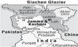
|
NOTE: Siachen Glacier was in the news. This is purely a map based question and anyone with a little bit of knowledge can easily solve this question. Observing the map carefully, East of Aksai Chin is China Administered Tibet, while Leh is situated South of Siachen, and Gilgit is on the western side of Siachen. |
Question 7
Consider the following pairs:
| River | Flow into |
| 1. Mekong | Andaman Sea |
| 2. Thames | Irish Sea |
| 3. Volga | Caspian Sea |
| 4. Zambezi | Indian Ocean |
Which of the pairs given above is/are correctly matched?
(a) 1 and 2 only
(b) 3 only
(c) 3 and 4 only
(d) 1, 2 and 4 only
ExplanationAns: c
Sub-Theme: Map based
Statement 1 is incorrect: The Mekong River originates in the icy headwaters of the Tibetan highlands. It flows through the steep canyons of China, known as the upper basin, through lower basin countries Myanmar, Laos, Thailand, and Cambodia, before fanning an expansive delta in Vietnam and emptying into the South China Sea.
Statement 2 is incorrect: It is the longest river in England, flowing 215 miles from the Cotswolds to the North Sea. The main tributaries of Thames are Buscot, Reading, and Kingston.
Statement 3 is correct: The Volga River, the longest river in Europe, runs through Russia with its delta flowing into the Caspian Sea just south of the Kazakhstan border.
Statement 4 is correct: The Zambezi is the fourth-largest river after the Congo/Zaire, Nile and Niger in Africa. It rises in the Kalene hills in north-western Zambia and flows eastwards for about 3000 km to the Indian Ocean.
Question 8
With reference to pulse production in India, consider the following statements:
Which of the statements given above is/are correct?
(a) 1 only
(b) 2 and 3 only
(c) 2 only
(d) 1, 2 and 3
ExplanationAns: a
Sub-Theme: Major crops
Statement 1 is correct: In India, the important pulse crops grown in winter (rabi) are chickpea, lentil, lathyrus, field pea and kidney bean. However, green gram, black gram and cowpea are grown in both spring and rainy season.
Statement 2 is incorrect: According to the Directorate of Economics and Statistics (DES), the share of pulse production in 2018- 19 was comprised of Tur (15.34%), Gram (43.29%), Moong (green gram,10.04%), Urad (black gram, 13.93%), Lentil (6.67%), and Other Pulses (10%).
Statement 3 is incorrect: In the last three decades, both, the production of kharif pulses and the production of rabi pulses have increased.
2019
Question 1
On 21st June, the Sun:
(a) Does not set below the horizon at the Arctic Circle
(b) Does not set below the horizon at Antarctic Circle
(c) Shines vertically overhead at noon on the Equator
(D) Shines vertically overhead at the Tropic of Capricorn
ExplanationAns: a
Sub-Theme: Motion of Earth
Option (a) is correct: Areas near the poles receive less heat as the rays of the sun are slanting.The North Pole is inclined towards the sun and the places beyond the Arctic Circle experience continuous daylight for about six months.
Summer Solstice (21st June):
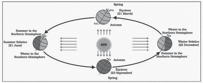
Revolution of the Earth and Seasons
Question 2
Why are dewdrops not formed on a cloudy night?
(a) Clouds absorb the radiation released from the Earth’s surface.
(b) Clouds reflect back the Earth’s radition.
(c) The Earth’s surface would have low temperatures on cloudy nights.
(d) Clouds deflect the blowing wind to ground level
ExplanationAns: b
Sub-Theme: Dew Formation/Water in Atmosphere
Option (b) is correct: The dew drops are not formed on a cloudy night because the Clouds reflect back the Earth’s radiation.
Question 3
With reference to the management of minor minerals in India, consider the following statements:
Which of the statements given above is/are correct?
(a) 1 and 3 only
(b) 2 and 3 only
(c) 3 only
(d) 1, 2 and 3
ExplanationAns: a
Sub-Theme: Minor Minerals in india
Statement 1 is correct: Sand is a ‘minor mineral’ according to the prevailing law in the country.
Statement 2 is incorrect: Any mineral which by the notification of the Central Government may declare to be a minor mineral.
Statement 3 is correct: The State Government may, by notification in the Official Gazette, make rules for regulating the grant of quarry leases, mining leases or other mineral concessions in respect of minor minerals and for purposes connected there with.
Question 4
With reference to the cultivation of Kharif crops in which in the last five years, consider the following statements:
Which of the statements given above is/are correct?
(a) 1 and 3 only
(b) 2, 3 and 4 only
(c) 2 and 4 only
(d) 1, 2, 3 and 4
ExplanationAns: a
Sub-Theme: Major Crops
Statement 1 is correct: The area under rice cultivation in India, in 2013-14 was 44.13 million hectares while in 2015-16, it became 43.39 million hectares and is highest amongst all.
Statement 2 is incorrect: The annual area under Jowar ranges between 17 and 18 million hectares while the oilseed area is 28 million hectares (2013-14), 26.1 million hectares (2015-16) i.e area under the cultivation of Jowar is less than that of oilseeds.
Statement 3 is correct: The area under sugarcane cultivation is 4.99 million hectares (2013-14), 5.066 million hectares (2014-15), 4.953 million hectares (2015-16). The area under cotton cultivation is 11.96 million hectares (2013-14), 12.81 million hectares (2014-15), and 11.87 million hectares (2015-16). Hence the area under cotton cultivation is more than sugar cultivation.
Statement 4 is incorrect: The area under sugarcane cultivation has not steadily decreased.
Question 5
What is common to the places known as Aliyar, Isapur and Kangsabati?
(a) Recently discovered uranium deposits
(b) Tropical rain forests
(c) Underground cave systems
(d) Water reservoirs
ExplanationAns: d
Sub-Theme: Current Affairs
Aliyar, Isapur and Kangsabati are the names which have water reservoirs common to the people.
About Water Reservoirs:
Question 6
Consider the following pairs:
|
Famous Place |
River |
| 1. Pandharpur | Chandrabhaga |
| 2. Tiruchirappalli | Cauvery |
| 3. Hampi | Malaprabha |
Which of the pairs given above are correctly matched?
(a) 1 and 2 only
(b) 2 and 3 only
(c) 1 and 3 only
(d) 1, 2 and 3
ExplanationAns: a
Sub-Theme: Famous places of India
Pair 1 is correct: Pandharpur city is on the banks of Chandrabhaga River in Maharashtra. The famous Lord Vitthal-Rukmini Mandir is located in this city.
Pair 2 is correct: Tiruchirappalli is an Indian city of Tamil Nadu on the banks of river Cauvery. The famous Sri Ranganathaswamy Temple is located in Tiruchirappalli.
Pair 3 is incorrect: Hampi was the capital of the Vijayanagara kingdom and is located on the bank of the Tungabhadra River in present state of Karnataka. Many famous temples like Virupaksha Temple, Nandi Statue etc are located in Hampi. Pattadakal or Pattadakal is situated on the banks of the river Malaprabha and is located in Karnataka.
Question 7
Consider the following pairs:
|
Sea |
Bordering Country |
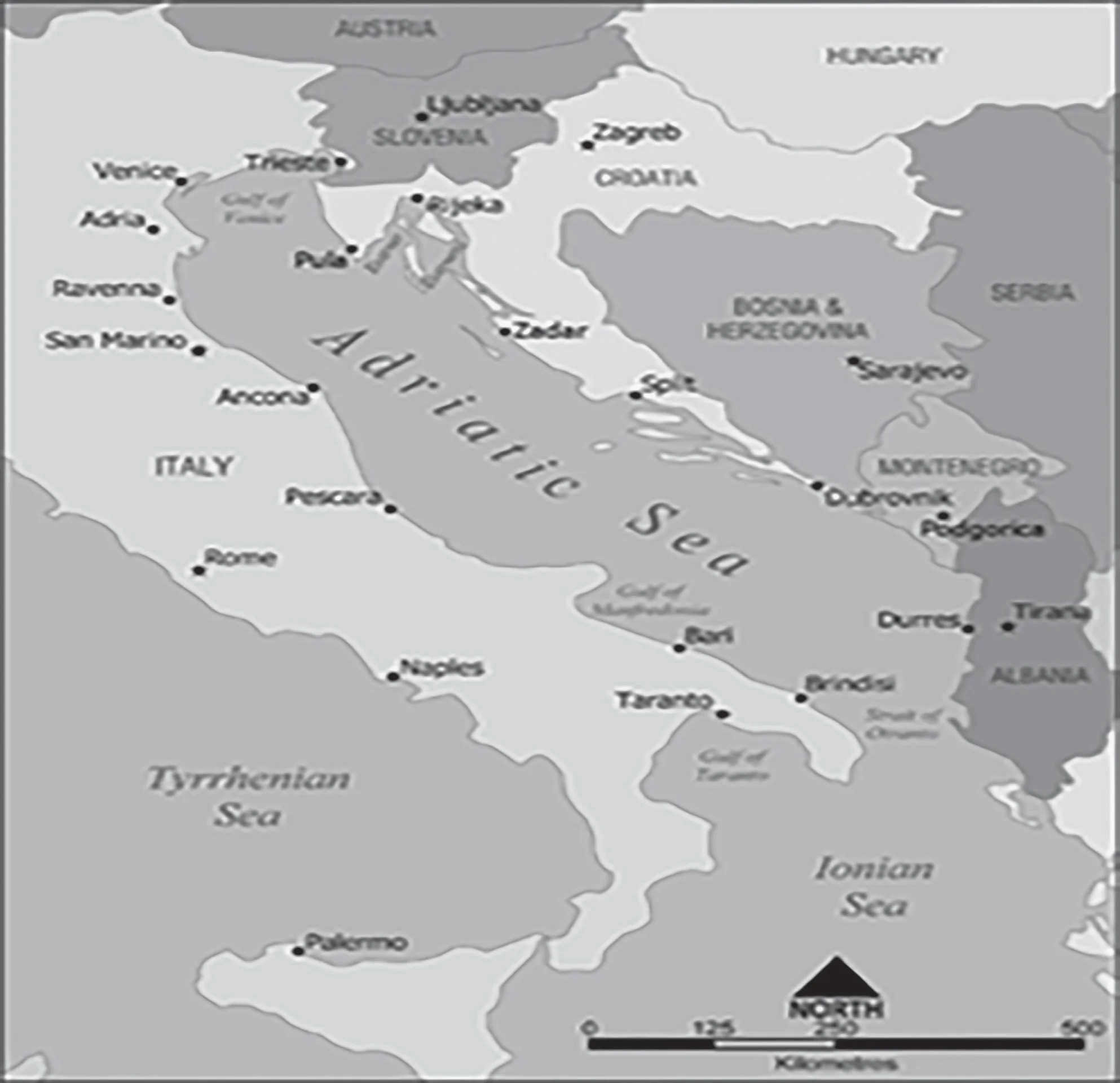
| 1. Adriatic Sea | Albania |
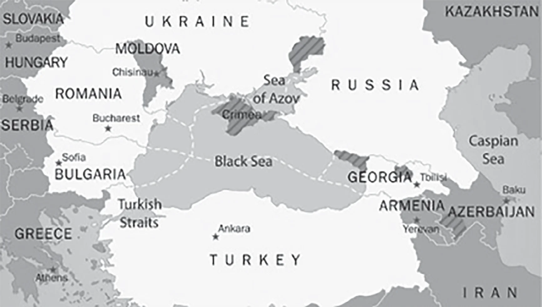
| 2. Black Sea | Croatia |
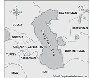
| 3. Caspian Sea | Kazakhstan |
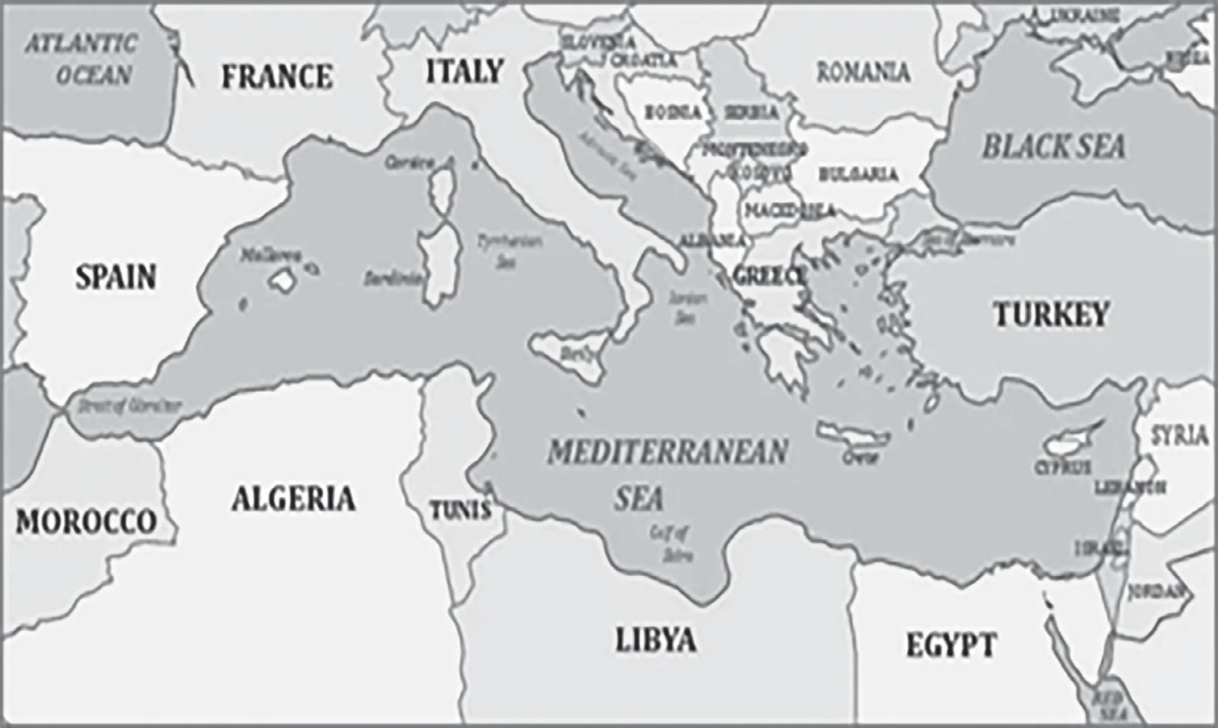
| 4. Mediterranean Sea | Morocco |
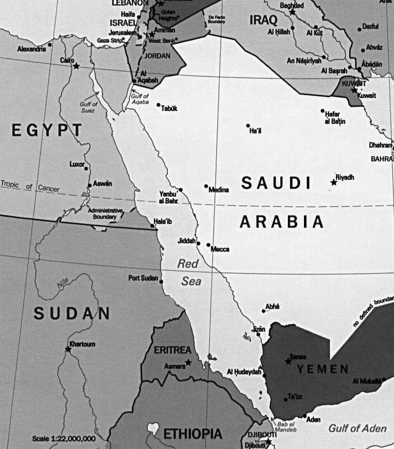
| 5. Red Sea | airyS |
Which of the pairs given above are correctly matched?
(a) 1, 2 and 4 only
(b) 1, 3 and 4 only
(c) 2 and 5 only
(d) 1, 2, 3, 4 and 5
ExplanationAns: b
Sub-Theme: World Map
Pair 1 is correct: The Adriatic Sea is a body of water separating the Italian Peninsula from the Balkan peninsula. The countries with coasts on the Adriatic sea: Albania, Bosnia and Herzegovina, Croatia, Italy, Montenegro and Slovenia. Mnemonic: ISC-MBA (Italia, Slovenia, Croatia, Montenegro, Bosnia, Albania).
Pair 2 is incorrect: Black Sea is a large inland sea situated at the southeastern extremity of Europe. It is bordered by Ukraine to the north, Russia to the northeast, Georgia to the east, Turkey to the south, and Bulgaria and Romania to the west. Black Sea is not bordered by Croatia. Mnemonic: Tea & BURGeR (Turkey, Bulgaria, Ukraine, Russia, Georgia, Romania).
Pair 3 is correct: Caspian Sea is the world’s largest inland body of water, variously classed as the world’s largest lake or a full-fledged sea. It is an endorheic basin (a basin without outflows) located between Europe and Asia. It is bounded by Kazakhstan to the northeast, Russia to the northwest, Azerbaijan to the west, Iran to the south, and Turkmenistan to the southeast. Mnemonic: TARIK (Turkmenistan, Azerbaijan, Russia, Iran, Kazakhstan).
Pair 4 is correct: The Mediterranean Sea is an intercontinental sea that stretches from the Atlantic Ocean on the west to Asia on the east and separates Europe from Africa. The countries surrounding the Mediterranean in clockwise order: Spain, France, Monaco, Italy, Slovenia, Croatia, Bosnia and Herzegovina, Montenegro, Albania, Greece, Turkey, Syria, Lebanon, Israel, Egypt, Libya, Tunisia, Algeria, and Morocco.
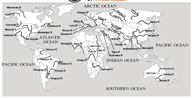
Pair 5 is incorrect: Red Sea is a narrow strip of water extending south-eastward from Suez, Egypt, for about 1,930 km to the Bab-el-Mandeb Strait, which connects with the Gulf of Aden and thence with the Arabian Sea. The six countries bordering the Red Sea: Saudi Arabia, Yemen, Egypt, Sudan, Eritrea and Djibouti. The Red Sea is not bordered by Syria. Mnemonic: DESSEY (Djibouti, Eritrea, Saudi Arabia, Sudan, Egypt, Yemen).
2018
Question 1
Consider the following statements
Which of the statements given above is/are correct?
(a) 1 and 2 only
(b) 3 only
(c) 1 and 3 only
(d) 1, 2 and 3
ExplanationAns: d
Sub-Theme: Coral reef distribution
Statement 1 is correct: The majority of reef- building corals are found within tropical and subtropical waters. These typically occur between 30° north and 30° south latitudes.
 Indian Ocean Dipole (IOD): Neutral Phase
Statement 2 is correct: The Indonesian/ Philippines archipelago, Great Barrier Reef of Australia, the Red Sea, and the Caribbean has the world’s greatest concentration of reefs and the greatest coral diversity.
Statement 3 is correct: Some scientists estimate that more than 25,000 described species from thirty-two of the world’s thirty-three animal phyla live in reef habitats four times the number of animal phyla found in tropical rainforests.
Question 2
Consider the following statements:
Which of the statements given above is/are correct?
(a) 1 and 2
(b) 2 only
(c) 1 and 3
(d) 3 only
ExplanationAns: d
Sub-Theme: Mines and Mineral/Mineral Rules
Statement 1 is incorrect: As per the MMDR Amendment Act 2015, the state governments will conduct auctions for grant of mineral concessions. The role of the central government is to prescribe the terms and conditions and procedures subject to which the auction shall be conducted.
Statement 2 is incorrect: Largest gold ore (primary) are located in Bihar (44%) followed by Rajasthan (25%) and Karnataka (21%), West Bengal, and Andhra Pradesh (3% each).
Statement 3 is correct: Hematite and magnetite are the most important iron ores in India and resources of hematite are spread in Andhra Pradesh, Assam, Bihar, Maharashtra, Madhya Pradesh, Meghalaya, Rajasthan and Uttar Pradesh.
Question 3
Which one of the following is an artificial lake?
(a) Kodaikanal (Tamil Nadu)
(b) Kolleru (Andhra Pradesh)
(c) Nainital (Uttarakhand)
(d) Renuka (Himachal Pradesh)
ExplanationAns: a
Sub-Theme: Important Lakes of India
About Kodaikanal Lake:
Question 4
Consider the following statements:
Which of the statements given above is/are correct?
(a) 1 only
(b) 2 and 3
(c) 3 only
(d) 1 and 3
ExplanationAns: a
Sub-Theme: Physiography of India
Statement 1 is correct: Barren Island Volcano is a part of Indian Union Territory of Andaman and Nicobar islands is an active volcano in South Asia (along a chain of volcanoes from Sumatra to Myanmar).
Statement 2 is incorrect: Barren Island is located in Andaman Sea, about 140 km northeast of Port Blair.
Statement 3 is incorrect: The last time the volcanic eruptions were reported and linked to 28 September 2018 earthquakes in Sulawesi, Indonesia.
| NOTE: In 2015 UPSC has asked a question on Andaman & Nicobar Island, so for detailed information on A&N Islands please refer to the 2015 PYQ. |
Question 5
Which of the following has/have shrunk immensely/ dried up the recent past due to human activities?
Select the correct answer using the code given below:
(a) 1 only
(b) 2 and 3
(c) 2 only
(d) 1 and 3
ExplanationAns: a
Sub-Theme: World Map/Environment and Ecology
About Aral Sea:

Question 6
Among the following cities, which one lies on a longitude closest to that of Delhi?
(a) Bengaluru
(b) Hyderabad
(c) Nagpur
(d) Pune
ExplanationLongitude of Indian Cities
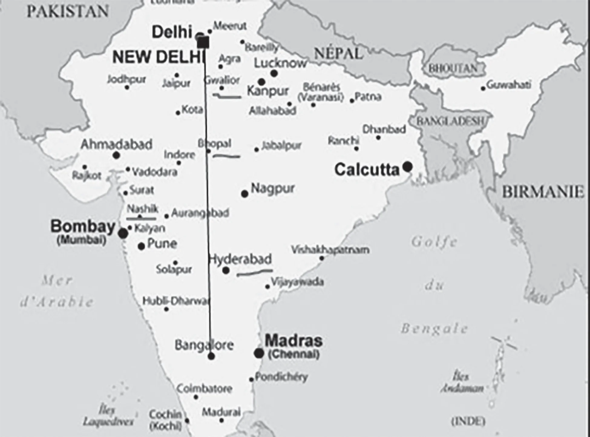
| NOTE: Map Practicing will not only help you to answer such questions but also it will help you to fetch some extra marks in UPSC Mains as well. |
Question 7
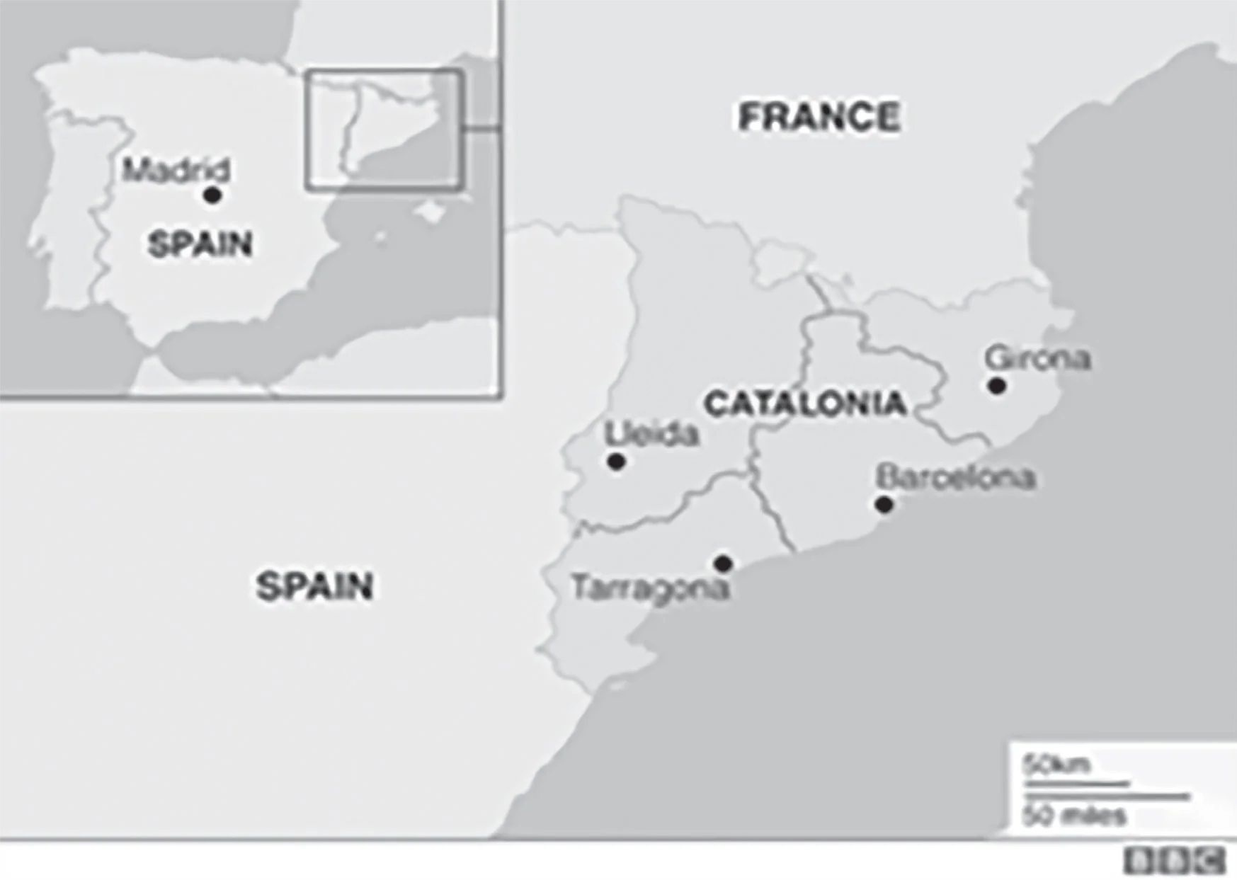
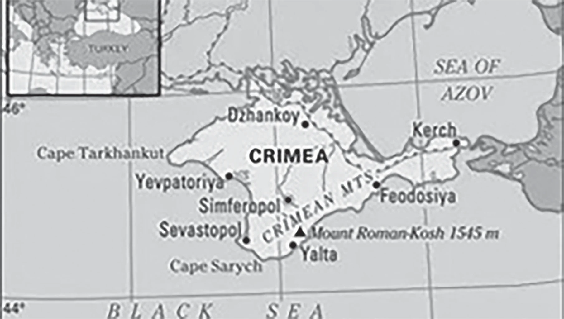
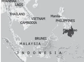
Consider the following pairs:
| Regions sometimes mentioned in news | Country |
| 1. Catalonia | Spain |
| 2. Crimea | Hungary |
| 3. Mindanao | Philippines |
| 4. Oromia | Nigeria |
Which of the pairs given above are correctly matched?
(a) 1, 2 and 3
(b) 3 and 4 only
(c) 1 and 3 only
(d) 2 and 4 only
ExplanationAns: c
Sub-Theme: Places was in News
Pair 1 is correct: Catalonia is located in Spain bordered by France and Andorra in the north, the Mediterranean Sea to the east, the autonomous community of Valencia to the south, and the autonomous community of Aragon to the west.
Pair 2 is incorrect: The Republic of Crimea, officially part of Ukraine, lies on a peninsula stretching from the south of Ukraine between the Black Sea and the Sea of Azov. It is separated from Russia by the narrow Kerch Strait.
Pair 3 is correct: Mindanao is an island located in the Philippines. It is surrounded by the Bohol, Philippine, Celebes, and Sulu seas.
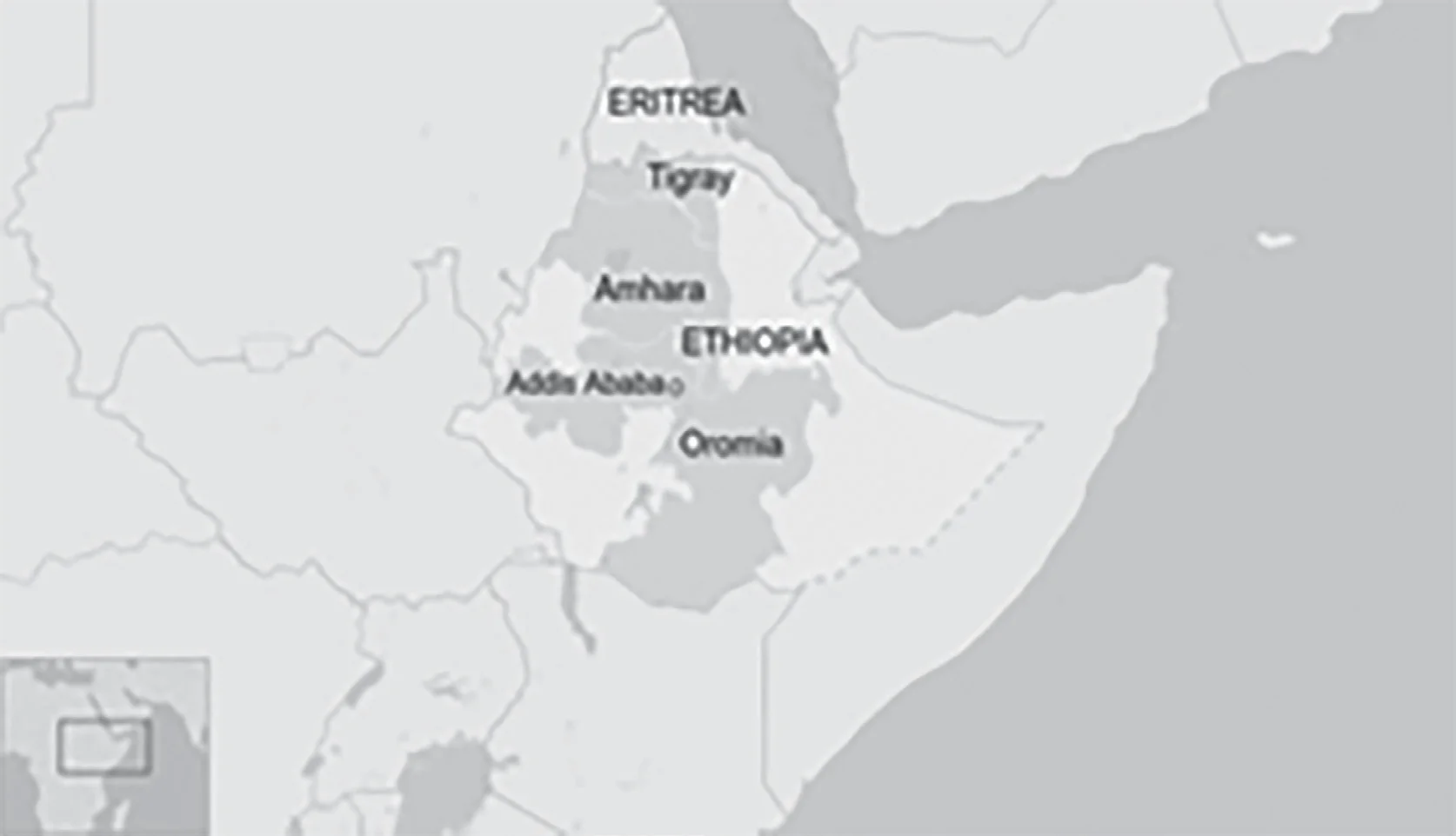
Pair 4 is incorrect: Oromia is a regional state of Ethiopia. Also, it is to be remembered that Ethiopia is a landlocked country located in Eastern Africa.
Question 8
Consider the following pairs:
| Towns sometimes mentioned in news | Country |
| 1. Aleppo | Syria |
| 2. Kirkuk | Yemen |
| 3. Mosul | Palestine |
| 4. Mazar-i-sharif | Afghanistan |
Which of the pairs given above are correctly matched?
(a) 1 and 2
(b) 1 and 4
(c) 2 and 3
(d) 3 and 4
Ans: b
Sub-Theme: Places in News
Name of Cities and Countries:
2017
Question 1
With reference to ‘Indian Ocean Dipole (IOD)’ sometimes mentioned in the news while forecasting Indian monsoon, which of the following statements is/are correct?
Select the correct answer using the code given below:
(a) 1 only
(b) 2 only
(c) Both 1 and 2
(d) Neither 1 nor 2
ExplanationAns: b
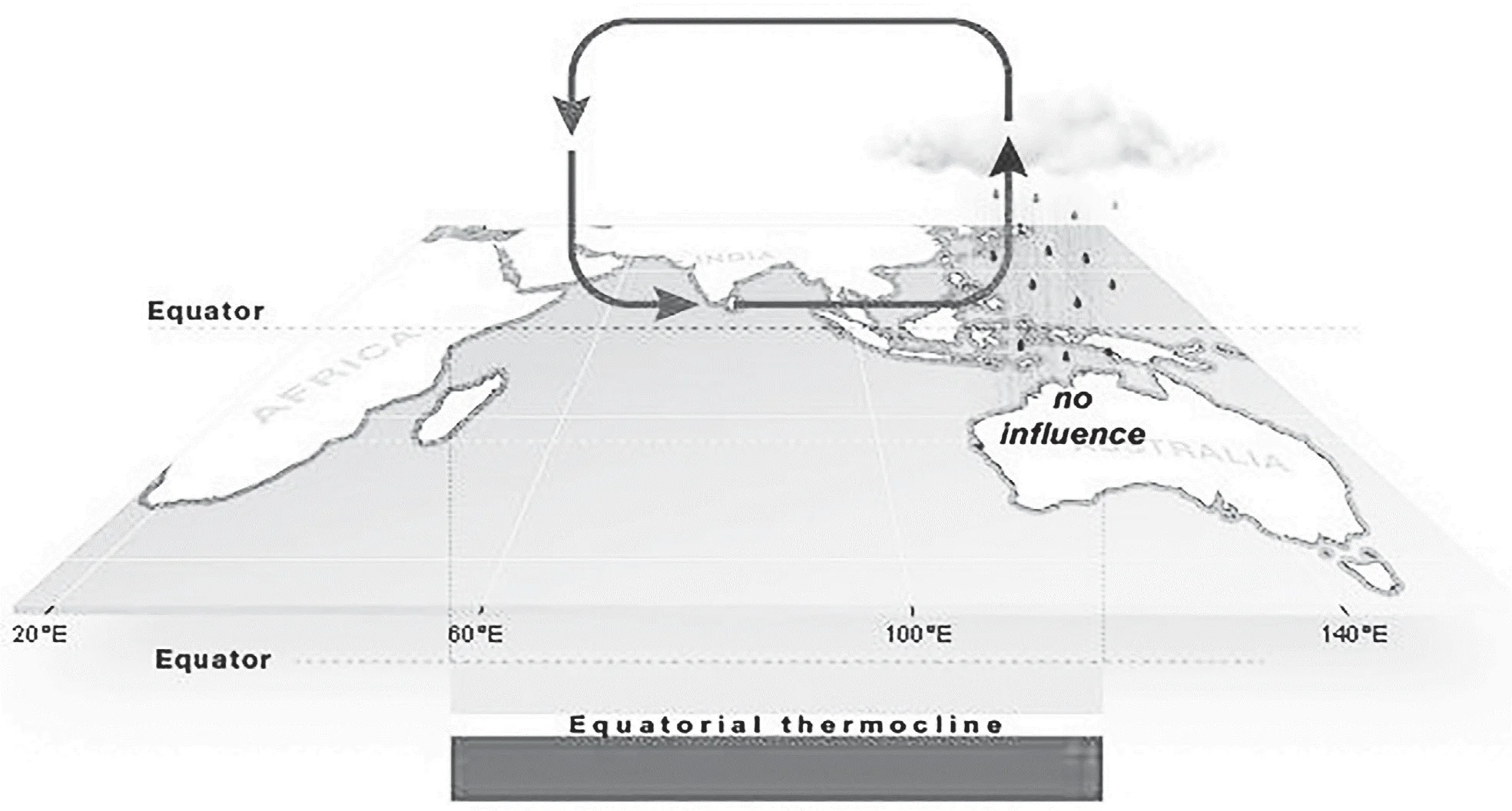
Sub-Theme: Indian Ocean Dipole
Statement 1 is incorrect: IOD is the difference in sea surface temperature between two poles or areas i.e. an eastern pole in the eastern Indian Ocean south of Indonesia, and a western pole in the Arabian Sea (western Indian Ocean).
Statement 2 is correct: Negative IOD events are often associated with La Nina and positive IOD events with El Nino.
Question 2
At one of the place in India, if you stand on the seashore and watch the sea, ‘you will find that the sea water recedes from the shore line a few kilometres and comes back to the shore, twice a day, and you can actually walk on the seafloor when the water recedes.’ This unique phenomenon is seen at
(a)Bhavnagar
(b) Bheemunipatnam
(c) Chandipur
(d) Nagapattinam
ExplanationAns: c
Sub-Theme: Basic Trivia
About Chandipur Sea Beach:
Question 3
With reference to river Teesta, consider the following statements:
1. The source of river Teesta is the same as that of Brahmaputra but it flows through Sikkim.
2. River Rangeet originates in Sikkim and it is a tributary of river Teesta.
3. River Teesta flows into Bay of Bengal on the border of India and Bangladesh.
Which of the statements given above is/are correct?
(a) 1 and 3 only
(b) 2 only
(c) 2 and 3 only
(d) 1, 2 and 3
ExplanationAns: b
Sub-Theme: Himalayan River/Drainage
Statement 1 is incorrect: Teesta originates in the Himalayas near Chunthang, Sikkim and flows to the south through West Bengal before entering Bangladesh.
Statement 2 is correct: River Rangeet originates in Sikkim, which is the largest river of Sikkim and also a tributary of river Teesta.
Statement 3 is incorrect: Originally, the river continued southward to empty directly into the Padma River (the main channel of Ganga in Bangladesh) but around 1787 the river changed its course to flow eastward to join the Jamuna river.
Question 4
Mediterranean Sea is a border of which of the following countries?
Select the correct answer using the code given below:
(a) 1, 2 and 3 only
(b) 2 and 3 only
(c) 3 and 4 only
(d) 1, 3 and 4 only
ExplanationAns: c
Sub-Theme: World Map
Mediterranean Sea Bordering countries:
Question 5
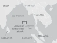
Which of the following is geographically closest to Great Nicobar?
(a) Sumatra
(b) Borneo
(c) Java
(d) Sri Lanka
ExplanationAns: a
Sub-Theme: Indian Ocean Region
About Great Nicobar:
Question 6
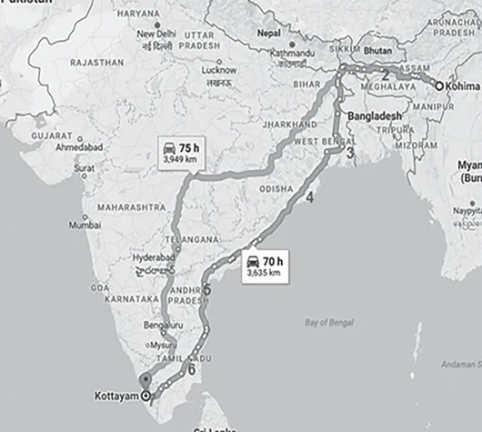
If you travel by road from Kohima to Kottayam, what is the minimum number of States within India through which you can travel, including the origin and the destination?
(a) 6
(b) 7
(c) 8
(d) 9
ExplanationAns: b
Sub-Theme: India Map
Question 7
Consider the following statements:
Which of the statements given above is/are correct?
(a) 1 and 2 only
(b) 3 only
(c) 2 and 3 only
(d) 1 and 3 only
ExplanationAns: b
Sub-Theme: India Map
Statement 1 is incorrect: The Himalayas is spread across 12 Indian States: Jammu & Kashmir, Uttarakhand, Himachal Pradesh, Arunachal Pradesh, Manipur, Meghalaya, Mizoram, Nagaland, Sikkim, Tripura, two districts of Assam namely Dima Hasao and Karbi Anglong and Darjeeling and Kalimpong in West Bengal).
Statement 2 is incorrect: The Western Ghats are spread over six states namely Kerala, Tamil Nadu, Karnataka, Goa, Maharashtra and Gujarat.
Statement 3 is correct: Pulicat Lake is the second largest brackish water lake in India and spreads over the two states namely Andhra Pradesh and Tamil Nadu. Large varieties of birds, including painted storks and Grey pelicans, frequent the area every year. Grey Pelican and Painted Stork both are near-threatened species under IUCN Red List of Threatened Species.
2016
Question 1
Consider the following pairs:
| Famous Place | Region |
| 1. Bodhgaya | Baghelkhand |
| 2. Khajuraho | Bundelkhand |
| 3. Shirdi | Vidarbha |
| 4. Nasik (Nashik) | Malwa |
| 5. Tirupati | Rayalaseema |
Which of the pairs given above are correctly matched? (a) 1, 2 and 4
(b) 2, 3, 4 and 5
(c) 2 and 5 only
(d) 1, 3, 4 and 5
ExplanationAns: c
Sub-Theme: Religious Places
Pair 1 is incorrect: Bodh Gaya is a holy landmark and pilgrimage destination linked with the Mahabodhi Temple Complex in Gaya, Bihar, India. It is one of the four main pilgrimage sites related with the life of Gautama Buddha, the other three are Kushinagar, Lumbini, Sarnath. In 2002, UNESCO declared the Mahabodhi Temple in Bodh Gaya a World Heritage Site.
Pair 2 is correct: The Khajuraho Temples in Madhya Pradesh’s Bundelkhand region are some of the most exquisite examples of medieval architecture in the world. It was built by the Chandela Dynasty between 950 and 1050 AD. There are Hindu and Jain temples among the monuments. In 1986, UNESCO designated these temples as World Heritage Sites. The temples are renowned for the symbolic architecture in the Nagara style. Initially reported in 1022 AD by Abu Raihan al Biruni and in AD 1335 by Ibn Battuta.
Pair 3 is incorrect: Shirdi is a city located in the Rahata taluka of Ahmednagar District, Maharashtra. According to legend, Sai Baba arrived in Shirdi in 1872 and remained there until his death on October 15, 1918.
Pair 4 is incorrect: Nashik is situated on the banks of river Godavari in the northwest region of Maharashtra and is famous for Kumbh Mela, which is held every 12 years.
Pair 5 is correct: Tirupati is a city situated in the Rayalaseema region of the Chittoor district of the Indian state of Andhra Pradesh. Shri Venkateswara Temple is well-known for being a Hindu temple.
Question 2
Which of the following is/are tributary/ tributaries of Brahmaputra?
Select the correct answer using the code given below.
(a) 1 only
(b) 2 and 3 only
(c) 1 and 3 only
(d) 1, 2 and 3
ExplanationAns: d
Sub-Theme: Himalayan Drainage System/ Brahmaputra
Option 1 and 3 are correct: Dhansiri, Dibang and Lohit are the left bank tributaries of Brahmaputra River.
Option 2 is correct: Kameng is a right bank tributary of Brahmaputra River. Other major right bank tributaries of Brahmaputra are Subansiri, Manas, Sankosh.
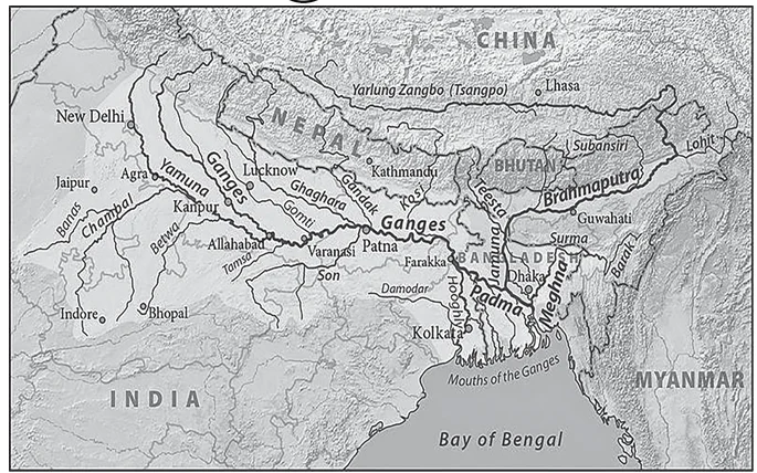
Question 3
In which of the following regions of India are shale gas resources found?
Select the correct answer using the code given below.
(a) 1 and 2 only
(b) 3 only
(c) 2 and 3 only
(d) 1, 2 and 3
ExplanationAns: d
Sub-Theme: Resource/Map
About Shale Gas in India:
2015
Question 1
In the South Atlantic and South-Eastern Pacific regions in tropical latitudes, cyclone does not What is the reason?
(a) Sea surface temperatures are low
(b) Inter-tropical Convergence Zone seldom occurs
(c) Coriolis force is too weak
(d) Absence of land in those regions
ExplanationAns: b
Sub-Theme: Wind Movement
Option (b) is correct: The absence of cyclones can be demonstrated by the seldom occurance of ITCZ Convergence zone in the south east Pacific and south Atlantic regions. Due to this there is no creation of ideal conditions for Tropical Cyclone, for e.g. instead of low, there is high vertical wind sheer.
Cyclone:
Classification of Cyclone:
Temperate cyclone
Factors Responsible for for Tropical Cyclone Formation:
Question 2
Consider the following statements:
1. The winds which blow between 30 N and 60 S latitudes throughout the year are known as westerlies.
2. The moist air masses that cause winter rains in North-Western region of India are part of westerlies
Which of the statements given above is/are correct?
(a) 1 only
(b) 2 only
(c) Both 1 and 2
(d) Neither 1 nor 2
ExplanationAns: b
Sub-Theme: Wind Movement/Indian Monsoon Option (b) is correct: Generally the westerlies flow between 30° and 60°N and 30° and 60°S
latitude respectively. The moist air masses that
cause winter rains in North-Western region of India are part of westerlies which are also known as winter disturbances.
Westerlies:
|
Note: In this question, the examiner made a simple but difficult to observe change in latitudes i.e “30 N and 60 S latitudes” to make the statement incorrect. Always read questions carefully and cautiously. Although we read incorrect statements in the exam hall, our mind correlates it to what we have read in the textbook/standard book, making it difficult to identify minor twists and twicks. Earlier, UPSC had asked questions on westerlies in 2011. Revising PYQ and doing peripheral research is always important from prelims perspective. |
Question 3
“Each day is more or less the same, the morning is clear and bright with a sea breeze; as the Sun climbs high in the sky, heat mounts up, dark clouds form, then rain comes with thunder and lightning. But the rain is soon over.”
Which of the following regions is described in the above passage?
(a) Savannah
(b) Equatorial
(c) Monsoon
(d) Mediterranean
ExplanationAns: (b)
Sub-Theme: Biomes/World Climate
Option (b) is correct: The above sentence indicates the characteristics of the Equatorial region.
Equatorial Climate:
|
NOTE: Again a direct question came from GC Leong. Also please learn to identify keywords/keyphrases, anyone with a decent reading of NCERTs and GC Leong could easily answer this question. Questions on Equatorial climate have been repeated in 2013, therefore for detailed explanation on Equatorial Biomes please refer to respective PYQs. |
Question 4
What explains the eastward flow of the equatorial counter current?
(a) The Earth’s rotation on its axis
(b) Convergence of the two equatorial currents
(c) Difference in salinity of water
(d) Occurrence of the belt of calm near the equator
ExplanationAns: b
Sub-Theme: Equatorial Counter Currents
Option (a) is incorrect: As the earth rotates from west to east, water near the equator tends to move from east to west (due to the prevailing winds). This leads to the formation of Equatorial currents, both North and South of the equator.
Option (b) is correct: Piling up of water in the western pacific due to the convergence of the North Equatorial Current and South Equatorial Current. This piled up water then flows from west to east, under the effect of gravity, resulting in Counter Equatorial Current (CEC).
Option (c) is incorrect: Difference in salinity of water greatly influences vertical currents and its influence on horizontal movement is less significant.
Option (d) is incorrect: The Doldrums/ Equatorial belt around the Equator are zones of very calm winds, it has little effect on eastward flow of equatorial counter current.
Question 5
Tides occur in the oceans and seas due to which among the following?
Select the correct answer using the code given below.
(a) 1 only
(b) 2 and 3 only
(c) 1 and 3 only
(d) 1, 2 and 3
ExplanationAns: d
Sub-Theme: Formation of Tides
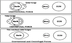
Question 6
In India, the steel production industry requires the import of:
(a) Saltpetre
(b) Rock phosphate
(c) Coking coal
(d) All of the above
ExplanationAns: c
Sub-Theme: Industry
Option (a) is incorrect: Saltpetre (Potassium nitrate) is not used in the production of Steel. It is used in the production of fertilizers, tree stump removal, rocket propellants and fireworks.
Option (b) is incorrect: Rock phosphate is used in the production of fertilizer and not for the production of Steel.
Option (c) is correct: The production of steel requires 0.8 tonnes of coking coal to produce one tonne of Steel. And about 85% of the coking coal requirement of the domestic steel industry is presently being met through imports.
Question 7
In India, in which one of the following types of forests is teak a dominant tree species?
(a) Tropical moist deciduous forest
(b) Tropical rainforest
(c) Tropical thorn scrub forest
(d) Temperate forest with Grasslands
ExplanationAns: a
Sub-Theme: Natural Vegetation of India About Tropical Moist Deciduous Forest:
Climatic Conditions:
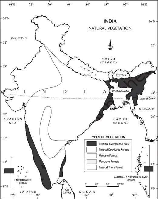
Characteristics:
Question 8
Consider the following rivers:
Which of the above are tributaries of Godavari?
(a) 1, 2 and 3
(b) 2, 3 and 4
(c) 1, 2 and 4
(d) 2 and 3 only
ExplanationAns: d
Sub-Theme: Peninsular Drainage/River
About River Godavari:
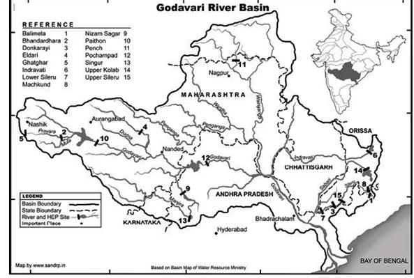
Additional Information:
Question 9
In a particular region in India, the local people train the roots of living trees into robust bridges across the As the time passes, these bridges become stronger. These unique ‘living root bridges’ are found in
(a) Meghalaya
(b) Himachal Pradesh
(c) Jharkhand
(d) Tamil Nadu
ExplanationAns: a
Sub-Theme: Living Root Bridges
Living root bridges also known as Jing Kieng Jri are found in Meghalaya are the aerial bridges that are built by weaving and manipulating the roots of the Indian rubber tree.
About Living Root Bridges:
Question 10
Consider the following States:
In which of the above States do ‘Tropical Wet Evergreen Forests’ occur?
(a) 1 only
(b) 2 and 3 only
(c) 1 and 3 only
(d) 1, 2 and 3
ExplanationAns: c
Sub-Theme: Natural Vegetation of India
Option 1 and 3 are correct: In India, tropical wet evergreen forests are found on the eastern and western slopes of the Western Ghats in such states like Tamil Nadu, Karnataka, Kerala and Maharashtra. And also found in Assam, Arunachal Pradesh, Meghalaya, Nagaland, Tripura, Mizoram, West Bengal and Andaman and Nicobar Islands.
Option 2 is incorrect: Himachal Pradesh comes under the Montane type of forest.
Question 11
Which one of the following regions of India has a combination of mangrove forest, evergreen forest and deciduous forest?
(a) North Coastal Andhra Pradesh
(b) South-West Bengal
(c) Southern Saurashtra
(d) Andaman and Nicobar Islands
ExplanationAns: d
Sub-Theme: Natural vegetation of India
About Andaman and Nicobar Islands:
The Andaman and Nicobar Islands have a tropical rainforest canopy. The Middle Andamans harbours mostly moist deciduous forests. North
Andamans is characterised by the wet evergreen type, with plenty of woody climbers. Also The coastal regions have mangrove forests.
Question 12
Which one of the following pairs of States of India indicates the easternmost and westernmost State?
(a) Assam and Rajasthan
(b) Arunachal Pradesh and Rajasthan
(c) Assam and Gujarat
(d) Arunachal Pradesh and Gujarat
ExplanationAns: d
Sub-Theme: Basic Understanding of Indian map
Most Points of India:
Question 13
Consider the following pairs:
| Place of Pilgrimage | Location |
| 1. Srisailam | Nallamala Hills |
| 2. Omakareshwar | Satmala Hills |
| 3. Pushkar | Mahadeo Hills |
Which of the above pairs is/are correctly matched?
(a) 1 only
(b) 2 and 3 only
(c) 1 and 3 only
(d) 1, 2 and 3
ExplanationAns: a
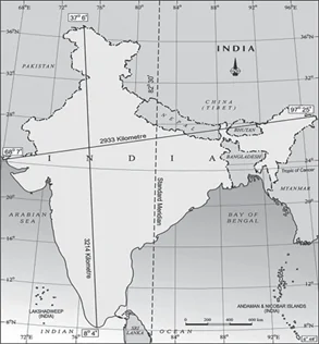
Sub-Theme: Famous pilgrim places of India
Pair 1 is correct: Srisailam is the shrine of Lord Mallikarjuna on the flat top of Nallamala Hills in Andhra Pradesh.The temple is dedicated to the deities Shiva and Parvati. This temple is one of Lord Shiva’s twelve Jyotirlingas and one of Goddess Parvati’s eighteen Shakti Peethas. The lingam is a representation of Shiva, who is worshiped as Mallikarjuna. Bhramaramba is a representation of Parvati.
Pair 2 is incorrect: Omkareshwar is situated on the Mandhata hills in Madhya Pradesh (ancient name: Shivpuri). The name “Omkareshwar” comes from the way the River Narmada flows here as it circles the Mandhata hill in the shape of a “Om.” Omkareshwar is a Hindu temple where the god Shiva is worshiped. It is one of Shiva’s 12 cherished Jyotirlinga shrines.
Pair 3 is incorrect: The Mahadeo Hills are a range of hills in Madhya Pradesh state of central India. Whereas, Pushkar is situated on the shore of Pushkar Lake in Ajmer, Rajasthan. It is famous for the red spired Brahma Temple.
Question 14
Which one of the following countries of South-West Asia does not open out to the Mediterranean Sea?
(a) Syria
(b) Jordan
(c) Lebanon
(d) Israel
ExplanationAns: b
Sub-Theme: World Map
Correct answer is Option (b): Jordan is a landlocked country and doesn’t have any opening into the Mediterranean Sea.
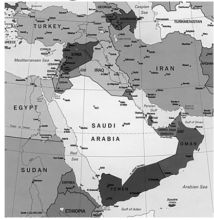
NOTE: In terms of world map, UPSC absolutely loves this region and there are many instances that they have asked questions from this region. Also, This region also very much remains in the news. Therefore, reading newspapers and practicing maps is very important for UPSC.
2014
Question 1
The seasonal reversal of winds is the typical characteristic of
(a) Equatorial climate
(b) Mediterranean climate
(c) Monsoon climate
(d) All of the above climates
ExplanationAns: c
Sub-Theme: Biomes/World Climate The Monsoon Climate (Am):
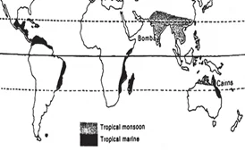
The monsoon climate is a type of weather where it rains a lot.
Question 2
Which of the following phenomena might have influenced the evolution of organisms?
Select the correct answer using the code given below.
(a) 1 only
(b) 2 only
(c) Both 1 and 2
(d) Neither 1 nor 2
ExplanationAns: c
Sub-Theme: Evolution vs Glacial cycle
Factors that might have influenced the Evolution of Organisms:
Question 3
In India, the problem of soil erosion is associated with which of the following?
Select the correct answer using the code given below.
(a) 1 and 2 only
(b) 2 only
(c) 1 and 3 only
(d) 1, 2 and 3
ExplanationAns: b
Sub-Theme: Soil degradation
Statement 1 is incorrect: Terracing is the practice of creating nearly level areas in a hillside area. protected from erosion by other soil barriers.
Statement 2 is correct: Deforestation is one of the major reasons for soil erosion. It includes cutting and felling of trees, removal of forest litter. Browsing and trampling by livestock, forest fires, also leads to deforestation, etc.
Statement 3 is incorrect: In the tropical monsoon climate people are mainly engaged in agriculture. Crops growing: rice, wheat, pulses, cotton, jute, sugarcane, oilseeds, coffee, tea and various types of fruits and vegetables.
Question 4
Consider the following pairs:
| Region | Well-known for the production of |
| 1. Kinnaur | Areca nut |
| 2. Mewat | Mango |
| 3. Coromandel | Soya bean |
Which of the above pairs is/are correctly matched?
(a) 1 and 2 only
(b) 3 only
(c) 1, 2 and 3
(d) None
ExplanationAns: d
Sub-Theme: Famous crop and places
Pair 1 is incorrectly matched: Kinnaur is mostly famous for apples. The production of Areca nuts is mostly confined to Karnataka, Kerala and Assam.
Pair 2 is incorrectly matched: The main occupation of Mewat is agriculture along with allied and agro-based activities, it is not famous for mango. Major mango-growing states are Andhra Pradesh, Uttar Pradesh, Karnataka,
Pair 3 is incorrectly matched: In the Coromandel Coast, major cultivations are Rice, pulses, sugarcane, cotton, peanuts, etc. Production of soybean in India is dominated by Maharashtra and Madhya Pradesh which contribute 89 percent of the total production.
Question 5
Consider the following towns of India:
Which of the above are famous for the production of traditional sarees/fabric?
(a) 1 and 2 only
(b) 2 and 3 only
(c) 1, 2 and 3
(d) 1, 3 and 4
ExplanationAns: b
Sub-Theme: Traditional Saree/fabric
Option 1 and 4 are incorrect: Bhadrachalam and Karnal are not famous for the production of traditional sarees/fabric.
Option 2 and 3 are correct: Chanderi sarees is a traditional sari made in Chanderi, Madhya Pradesh, India. Kanjeevaram is a traditional sari from Kanchipuram, Tamil Nadu, India, that is usually handwoven in mulberry silk and has pure gold or silver zari that renders it a festive quality.
Question 6
If you travel through the Himalayas, you are likely to see which of the following plants are naturally growing there?
Select the correct answer using the code given below.
(a) 1 and 2 only
(b) 3 only
(c) 1 and 3 only
(d) 1, 2 and 3
ExplanationAns: a
Sub-Theme: Natural Vegetation of India
Statement 1 is correct: Evergreen broad-leaf trees, such as oaks and chestnuts, belong to wet temperate types of forests (1000 and 2000 metres).
Statement 2 is correct: Coniferous trees like Rhododendron, pine, deodar, silver fir, spruce and cedar, are found in the temperate forests (1500 and 3000 metres).
Statement 3 is incorrect: Sandalwoods are found in tropical moist deciduous forests or monsoon forests which are found in western ghats, Deccan plateau, northern plains.
|
NOTE: This is straight from Class 9 Geography NCERT Chapter 5. This underlines the importance of reading NCERTs both for UPSC Pre and Mains perspective. |
Question 7
With reference to ‘Changpa’ community of India, consider the following statements:
Which of the statements given above is/are correct ?
(a) 1 only
(b) 2 and 3 only
(c) 3 only
(d) 1, 2 and 3
ExplanationAns: b
Sub-Theme: Tribe of India
Statement 1 is incorrect: The Changpa are a semi-nomadic people, they are mainly found in the Changtang, a high plateau that stretches across the cold desert of Ladakh.
Statement 2 is correct: They are raised for ultra- fine cashmere wool, also known as pashmina once woven.
Statement 3 is correct: In 1989, Changpas were declared as the Scheduled Tribes.
Question 8
Which of the following have coral reefs?
Select the correct answer using the code given below.
(a) 1, 2 and 3 only
(b) 2 and 4 only
(c) 1 and 3 only
(d) 1, 2, 3 and 4
ExplanationAns: a
Sub-Theme: Coral Reef
Coral reefs are underwater ecosystems formed by colonies of tiny animals called coral polyps. These animals secrete a hard, calcium carbonate exoskeleton that provides a foundation for the growth of other corals and a diverse array of marine organisms. Coral reefs are found in tropical and subtropical waters around the world, particularly in the Pacific Ocean, the Indian Ocean, and the Caribbean Sea.
Statement 1, 2 and 3 are correct: Coral reefs in India are found in a lot of areas including the Gulf of Kutch, Gulf of Mannar, Palk Bay, Andaman & Nicobar and Lakshadweep Islands.
Statement 4 is incorrect: Sundarban is the largest deltaic region of the world and encompasses over hundreds of islands (105), with a maze of innumerable rivers, rivulets, and creeks but does not have any coral reef.
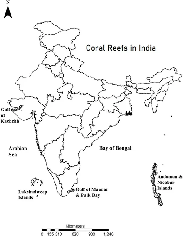
Question 9
Consider the following pairs:
| National Highway | Cities Connected |
| 1. NH4 | Chennai and Hyderabad |
| 2. NH6 | Mumbai and Kolkata |
| 3. NH15 | Ahmedabad and Jodhpur |
Which of the above pairs is/are correctly matched ?
(a) 1 and 2 only
(b) 3 only
(c) 1, 2 and 3
(d) None
ExplanationAns: d
Sub-Theme: National Highway/Map based
| National Highway | Cities Connected | Length (km) |
| NH 4 | Mayabunder to Port Blair- Chidiyatapu (Andaman) | 230 |
| NH 6 | Jorabat (Meghalaya) – Selling (Mizoram) | 1873 |
| NH 15 | Baihat (Assam) – Wakro (Arunachal Pradesh) | 664 |
Question 10
Which one of the following pairs of islands is separated from each other by the ‘Ten Degree Channel’?
(a) Andman and Nicobar
(b) Nicobar and Sumatra
(c) Maldives and Lakshadweep
(d) Sumatra and Java
ExplanationAns: a
Sub-Theme: Andaman Map based
The 10 degree channel is a water body that separates Andaman in the North and Nicobar in the South. Both the Andaman Islands and Nicobar Islands together form the Indian Union Territory (UT) of Andaman and Nicobar Islands.
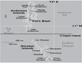
Additional Information:
Question 11
Consider the following pairs:
1. Dampa Tiger Reserve : Mizoram
2. Gumti Wildlife Sanctuary : Sikkim
3. Saramati Peak : Nagaland
Which of the above pairs is/are correctly matched?
(a) 1 only
(b) 2 and 3 only
(c) 1 and 3 only
(d) 1, 2 and 3
Ans: c
Sub-Theme: Major places of States
Statement 1 is correct: The Dampa tiger reserve is located in Mizoram. It is located in the Lushai Hills and spans an area of around 500 km2 at an altitude of 800-1,100 m. It is a component of Project Tiger and was designated a tiger reserve in 1994.
Statement 2 is incorrect: Gumti Wildlife Sanctuary is a Wildlife Sanctuary in Tripura. This sanctuary is the place for many animals like elephants, sambar, buffalo, yapping deer, wild goats and numerous more. The sanctuary has become a haven for reptiles as well.
Statement 3 is correct: Saramati peak rising above the surrounding peaks at the mountainous border of Nagaland state, India. It is one of the ultra-prominent peaks of Southeast Asia. It forms a natural boundary between India and Myanmar.
Question 12
Consider the following rivers:
Which of the above flows/flow through Arunachal Pradesh?
(a) 1 only
(b) 2 and 3 only
(c) 1 and 3 only
(d) 1, 2 and 3
ExplanationAns: b
Sub-Theme: Brahmaputra and its tributary
Statement 1 is incorrect: Barak river is one of the major rivers of South Assam. The 564 km long river is part of the Surma-Meghna River System. It rises in the Manipur Hills in northern Manipur state, India, where it is called the Barak. The Barak River flows through the states of Manipur, Nagaland, Mizoram, and Assam in India and into the Bay of Bengal.
Statement 2 is correct: Lohit River is a tributary of the Brahmaputra River. It flows into Arunachal Pradesh after starting from eastern Tibet’s Zayal Chu range.
Statement 3 is correct: Both the Tibetan Autonomous Region of China and the Indian states of Assam and Arunachal Pradesh are traversed by the Subansiri River. It is the biggest tributary of River Brahmaputra.
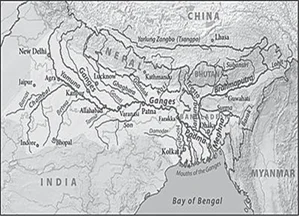
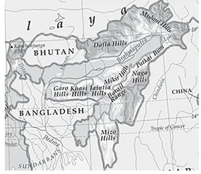
Question 13
Consider the following pairs:
| Hills | Region |
| 1. Cardamom Hills | Coromandel Coast |
| 2. Kaimur Hills | Konkan Coast |
| 3. Mahadeo Hills | Central India |
| 4. Mikir Hills | North-East India |
Which of the above pairs are correctly matched?
(a) 1 and 2
(b) 2 and 3
(c) 3 and 4
(d) 2 and 4
ExplanationAns: c
Sub-Theme: Physiography of India/Map based
Pair 1 is incorrect: Cardamom Hills are located in Kerala and south-west Tamil Nadu. It is situated on India’s southwest coast, whereas, the Coromandel coast is located in Tamil Nadu’s eastern coastal plain
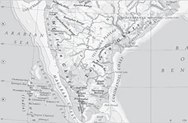
Pair 2 is incorrect: Kaimur Hills is in the eastern portion of the Vindhya Range, present in Madhya Pradesh, Uttar Pradesh and Bihar.
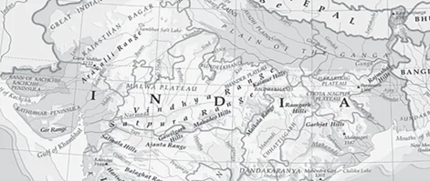
Pair 3 is correct: Mahadeo Hills are located in the northern part of the Satpura Range in Madhya Pradesh state of central India.
Pair 4 is correct: Mikir Hills can be found in Assam, south of Kaziranga National Park. It is a region of the Karbi- Plateau in northeastern India. The highest mountain in the Mikir Hills is Dambuchko.
Question 14
Turkey is located between:
(a) Black Sea and Caspian Sea
(b) Black Sea and Mediterranean Sea
(c) Gulf of Suez and Mediterranean Sea
(d) Gulf of Aqaba and Dead Sea
ExplanationAns: b
Sub-Theme: World Map
Option (b) is correct: Turkey is located between Black Sea and Mediterranean Sea.
About Geographic Boundary of Turkey:
Turkey is bordered on its northern side by the Black Sea, on its northeast by Georgia and Armenia, on its east by Azerbaijan and Iran, on its southeast by Iraq and Syria, on its southwest and western edges by the Mediterranean Sea and the Aegean Sea, and on its northwest by Greece and Bulgaria.
Question 15
What is the correct sequence of occurrences of the following cities in South-East Asia as one proceeds from south to north?
Select the correct answer using the code given below:
(a) 4-2-1-3
(b) 3-2-4-1
(c) 3-4-1-2
(d) 4-3-2-1
ExplanationAns: c
Sub-Theme: Major cities/capital cities
The correct sequence of cities in South-East Asia as one proceeds from south to north would be Jakarta > Singapore > Bangkok > Hanoi.
2013
Question 1
Variations in the length of daytime and night time from season to season are due to:
(a) The earth’s rotation on its axis
(b) The earth’s revolution around the sun in an elliptical manner
(c) Latitudinal position of the place
(d) Revolution of the earth on a tilted axis
ExplanationAns: d
Sub-Theme: Motion of the Earth
Option (d) is correct: Variations in the length of daytime and night time from season to season due to revolution of the earth on a tilted axis. Movement of the earth around the sun in a fixed path or orbit.It takes 365¼ days (one year) to revolve around the sun. As a result of the earth’s revolution, you can observe that there are days and nights as well as seasonal fluctuations.
Question 2
Which of the following is/are unique characteristic/ characteristics of equatorial forests?
Select the correct answer using the codes given below:
(a) 1 only
(b) 2 and 3 only
(c) 1 and 3 only
(d) 1, 2 and 3
ExplanationAns: d
Sub-Theme: Major Climate of the World
Statement 1 is correct: The tropical rain forest appears from above as a dense canopy of greenery, only disturbed by huge rivers or areas cleared for farming.
Statement 2 is correct: The higher temperatures in the tropics cause higher rates of metabolism, ecological dynamics and coevolutionary processes, which generate and maintain higher biodiversity, which results in the coexistence of a large number of species.
Statement 3 is correct: All plants (most epiphytes) strive upwards for sunshine, resulting in an odd layer structure. Numerous evergreen trees that produce tropical hardwoods like mahogany, ebony, dyewoods, etc. make up the equatorial vegetation.
Natural Vegetation:
Question 3
The annual range of temperature in the interior of the continents is high as compared to coastal areas. What is/are the reason/reasons?
Select the correct answer using the codes given below:
(a) 1 only
(b) 1 and 2 only
(c) 2 and 3 only
(d) 1, 2, 3 and 4
ExplanationAns: a
Sub-Theme: Distribution of the temperature of Earth
Statement 1 is correct: One major factor affecting the distribution of the temperature of Earth is the distribution of Land and Oceans. The loss of heat from the continents is greater than that from the oceans because there is more land in the northern hemisphere and more water in the southern hemisphere, and because the specific heat of land and water differs greatly.
Statement 2 is not correct: The variation in altitude between continents and oceans is not a valid reason for the high annual range of temperature in the interior of the continent as compared to coastal areas. This is because as compared to oceans, the lands heats up and cools down faster.
Statement 3 is not correct: Annual precipitation is usually low in the interior areas as well as the presence of weak winds in the interior.
Statement 4 is not correct: The interiors in Central Asia receive very poor rainfall due to distance from the sea.
Question 5
“Climate is extreme, rainfall is scanty and the people used to be nomadic herders.”
The above statement best describes which of the following regions?
(a) African Savannah
(b) Central Asian Steppe
(c) North American Prairie
(d) Siberian Tundra
ExplanationAns: b
Sub-Theme: Biomes/World Climate
Steppe Climate or Temperate Continental Climate or Temperate Grassland Climate:
Temperature:
Precipitation:
Nomadic herding in Asian Steppes
| NOTE: Learn to pick keywords/keyphrases from the sentence. Here – ‘extreme climate’; ‘scanty rainfall’; ‘nomadic herders’, etc. all these keywords resemble the characteristics of the Central Asian Steppe region. Earlier UPSC had asked questions about Tropical Savannah Region and equatorial climate in 2012 and 2013 respectively. So preparing about various Biomes/World Climate and their significant features is crucial. |
Question 6
During a thunderstorm, the thunder in the skies is produced by the:
Select the correct answer using the codes given below:
(a) 1 only
(b) 2 and 3
(c) 1 and 3
(d) None of the above produces the thunder
ExplanationAns: d
Sub-Theme: Wind Movement
Statement 1 is not correct: Thunder is the sound caused by a lightning discharge. Lightning heats the air in its path and causes a large over- pressure of the air within its channel. The channel expands supersonically into the surrounding air as a shock wave and creates an acoustic signal that is heard as thunder.
Statement 2 is not correct: The thunderstorms are associated with the cumulonimbus clouds not nimbus.
Statement 3 is not correct: The updraft and downdraft determine the path of the thunderstorm.
Additional Information:
Question 7
Which of the following statements regarding laterite soils of India are correct?
Select the correct answer using the codes given below:
(a) 1, 2 and 3
(b) 2, 3 and 4
(c) 1 and 4
(d) 2 and 3 only
ExplanationAns: c
Sub-Theme: Soil Characteristics
Statement 1 is correct: Laterite soil is reddish- brown in colour due to the presence of iron oxide.
Statement 2 is incorrect: Laterite soil is rich in bauxite or ferric oxide. Poor in lime, magnesia, potash and nitrogen.
Statement 3 is incorrect: The laterite soils are commonly found in Karnataka, Kerala, Tamil Nadu, Madhya Pradesh and the hilly areas of Orissa and Assam.
Statement 4 is correct: Suitable crops grown in laterite soil are Groundnut, cashew nut, coffee, rubber, cinchona, arecanut, tapioca, etc.
Question 8
Consider the following statements:
Which of the statements given above is/are correct?
(a) 1 and 2
(b) 2 only
(c) 2 and 3
(d) None
ExplanationAns: b
Sub-Theme: Gondwana System
Statement 1 is incorrect: Gondwana rocks contain nearly 98 per cent of India’s coal reserves.
Statement 2 is correct: Koderma is a well-known place for mica production in Jharkhand.
Statement 3 is incorrect: The Dharwar system is economically the most important rocks because they possess valuable minerals like high-grade iron-ore, manganese, copper etc not petroleum.
Question 9
Consider the following:
Which of the above are responsible for bringing dynamic changes on the surface of the earth?
(a) 1, 2, 3 and 4 only
(b) 1, 3, 5 and 6 only
(c) 2, 4, 5 and 6 only
(d) 1, 2, 3, 4, 5 and 6
ExplanationAns: d
Sub-Theme: Dynamic Changes of The Earth
Factors of The Dynamic Changes of The Earth:
Question 10
Contour bunding is a method of soil conservation used in:
(a) Desert margins, liable to strong wind action
(b) Low flat plains, close to stream courses, liable to flooding
(c) Scrublands, liable to spread of weed growth
(d) None of the above
ExplanationAns: d
Sub-Theme: Soil Conservation
Option (d) is correct: Contour bunding is a method of soil conservation used in Terrace Farming.
Question 11
Which of the following adds nitrogen to the soil?
Select the correct answer using the codes given below:
(a) 1 only
(b) 2 and 3 only
(c) 1 and 3 only
(d) 1, 2 and 3
ExplanationAns: c
Sub-Theme: Soil Fertility
Statements 1 and 3 are correct: Animal waste like urea, uric acid and death of vegetation add nitrogen in the form of nitrates directly into the soil.
Statement 2 is incorrect: Burning coal releases CO, CO2, sulphur dioxide and oxides of nitrogen – air pollutants to the atmosphere.
Question 12
Which of the following is/are the characteristic/ characteristics of Indian coal?
Select the correct answer using the codes given below:
(a) 1 and 2 only
(b) 2 only
(c) 1 and 3 only
(d) 1, 2 and 3
ExplanationAns: a
Sub-Theme: Major Mineral
Option (a) is correct: The India Coal is mainly characterised by High Ash COntent and Low Sulphur Content.
Question 13
Consider the following crops
Which of these are Kharif crops?
(a) 1 and 4 only
(b) 2 and 3 only
(c) 1, 2 and 3 only
(d) 2, 3 and 4 only
ExplanationAns: c
Sub-Theme: Major Crops
Option (c) is correct: Cotton, Groundnut and Rice are Kharif Crops in India.
About Kharif Crops:
About Rabi Crops:
Question 14
Which one among the following industries is the maximum consumer of water in India?
(a) Engineering
(b) Paper and pulp
(c) Textiles
(d) Thermal power
ExplanationAns: d
Sub-Theme: Water consumption Consumption of water in various industries:
Question 15
Consider the following pairs:
| Tribe | States |
| 1. Limboo (Limbu) | Sikkim |
| 2. Karbi | Himachal Pradesh |
| 3. Dongaria Kondh | Odisha |
| 4. Bonda | Tamil Nadu |
Which of the above pairs are correctly matched?
(a) 1 and 3 only
(b) 2 and 4 only
(c) 1, 3 and 4 only
(d) 1, 2, 3 and 4
ExplanationAns: a
Sub-Theme: Tribes of India
Pair 1 is correct: Tamang , Limbu, Bhutia, Khas, Lepchas are the tribal community of Sikkim.
Pair 2 is incorrect: Karbi is a tribal community from Karbi Anglong of Assam.
Pair 3 is correct: Dongaria tribal community is from Odisha.
Pair 4 is incorrect: Bonda is the most primitive tribal group in Odisha.
About Tribal Community and States:
Sikkim
Question 16
The Narmada River flows to the west, while most other large peninsular rivers flow to the Why?
Select the correct answer using the codes given
(a) 1 only
(b) 2 and 3
(c) 1 and 3
(d) None
ExplanationAns: a
Sub-Theme: West Flowing Peninsular Rivers
Statement 1 is correct: Narmada and Tapi flow through faults (linear rift, rift valley, trough) created due to the bending of the northern peninsula during the formation process of Himalayas.
Statement 2 is incorrect: Narmada flows through the faults, which run parallel to the Vindhyas and the Satpuras.
Statement 3 is incorrect: Narmada flows towards the west not because of land slopes to the west from central India, but it is flowing west because of the rift valleys only.
Question 17
Consider the following pairs:
| National Park | River flowing
through the Park |
| 1. Corbett National Park | Ganga |
| 2. Kaziranga National Park | Manas |
| 3. Silent Valley National Park | Kaveri |
Which of the above pairs is/are correctly matched?
(a) 1 and 2
(b) 3 only
(c) 1 and 3
(d) None
ExplanationAns: d
Sub-Theme: Geography of Protected Areas
Pair 1 is incorrect: Ramganga, Sonanadi, Mandal, Palain and Kosi are the major rivers flowing through the Corbett National Park.
Pair 2 is incorrect: The Kaziranga National Park is circumscribed by the Brahmaputra River, which forms the northern and eastern boundaries, and the Mora Diphlu, which forms the southern boundary. Other notable rivers within the park are the Diphlu and Mora Dhansiri.
Pair 3 is incorrect: The Kunthipuzha River drains the entire 15 km length of the Silent Valley park from north to south into the Bharathapuzha River.
Question 18
Consider the following pairs:
Which of the above pairs is/are correctly matched?
(a) 1 only
(b) 2 and 3 only
(c) 1, 2 and 3
(d) None
ExplanationAns: a
Sub-Theme: Map based
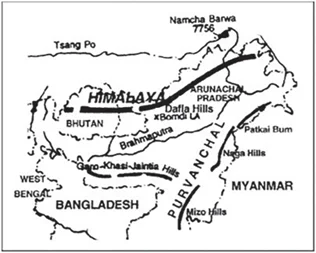
Pair 1 is correct: Nokrek Biosphere Reserve is located in the Garo Hills district of Meghalaya. The biosphere reserve’s name comes from Nokrek Hill, the highest peak of the Garo Hills. Nokrek National Park was included on UNESCO’s list of biosphere reserves in May 2009.
Pair 2 is incorrect: The Loktak Lake is a freshwater lake in Manipur, it is well-known for the phumdis that float above it. On this lake is Keibul Lamjao National Park, the only floating national park in the world. The northern, middle, and southern zones of the lake are separated.
Pair 3 is incorrect: Namdapha National Park is situated between the Dapha Bum range and the Patkai range in the Changlang district of Arunachal Pradesh. The Noa Dihing River runs east to west through the national park. It has dipterocarp woods, the northernmost lowland evergreen rainforests in the world.
Question 19
Which one of the following pairs is correctly matched?
| Geographical Feature | Region |
| (a) Abyssinian Plateau Arabia | Arabia |
| (b) Atlas Mountains | North-Western Africa |
| (c) Guiana Highlands | South-Western Africa |
| (d) Okavango Basin | Patagonia |
Ans: b
Sub-Theme: World Map
Atlas Mountain: The Maghreb, often referred to as Northwest Africa, the Greater Maghreb, and historically as the Barbary Coast, is where the Atlas Mountains is situated. The Atlas Mountains divide the Sahara Desert from the Mediterranean and Atlantic coasts. The highest point of this mountain range, Toubkal (4167 m), is found in Morocco. The mountains are found in Algeria and Tunisia in addition to Morocco. The Atlas Mountains are home to populations of Berber people.
Additional Information:
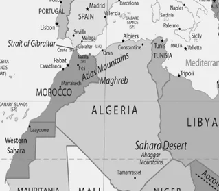
Abyssinian Plateau: The Ethiopian Plateau is also referred to as Altipiano Etiopico, Amhara Plateau, Ethiopian Massif, and Ethiopian Plateau. The Abyssinian Plateau was formerly known as Ethiopia, hence the name. The Blue Nile, which emerges from Lake Tana, is the most notable river to cross the plateau.
Okavango Basin: The Okavango Basin is situated in southwest Africa comprising Botswana, Namibia, Zimbabwe, Angola, and other countries. Whilst, Patagonia refers to a geographical region that encompasses the southern end of South America, governed by Argentina and Chile.
Guiana Highlands: In South America, the Guiana Highlands are situated in the south of the Orinoco River and north of the Amazon River. Parts of Venezuela, the Guianas, Brazil, and Colombia are included in the Guiana Highlands. Mount Roraima, located in the Guiana Highlands, has the highest elevation (2772 m).
2012
Question 1
A person stood alone in a desert on a dark night and wanted to reach his village which was situated 5 km east of the point where he was standing. He had no instruments to find the direction but he located the polestar. The most convenient way now to reach his village is to walk in the
(a) Direction facing the polestar
(b) Direction opposite to the polestar
(c) Direction keeping the polestar to his left
(d) Direction keeping the polestar to his right
ExplanationAns: c
Sub-Theme: Basics of Solar System
Option (a) is incorrect: The North star/Pole Star indicates the north direction, therefore walking in the direction of the pole star will lead him towards NORTH of his current position.
Option (b) is incorrect: Walking in the opposite direction will lead him towards SOUTH of his current position.
Option (c) is correct: Walking in the direction while keeping the polestar to his left would lead him towards EAST of his current position and he can reach his village.
Option (d) is incorrect: Walking in the direction while keeping the pole star to his right would lead him towards WEST of his current position.
|
Note: The Pole star is not visible from the southern hemisphere. Some of the north- ern constellations like Ursa Major may also not be visible from some points in the south- ern hemisphere. |
Question 2
Electrically charged particles from space traveling at speeds of several hundred km/sec can severely harm living beings if they reach the surface of the Earth. What prevents them from reaching the surface of the Earth?
(a) The Earth’s magnetic field diverts them towards its poles.
(b) Ozone layer around the Earth reflects them back to outer space.
(c) Moisture in the upper layers of the atmosphere prevents them from reaching the surface of the
(d) None of the statements (a), (b), and (c) given above is correct.
ExplanationAns: a
Sub-Theme: Basics of Solar System
Earth’s Magnetic Field Diverts Electrically Charged Particles:
Option (a) is correct: Earth’s field lines start near the South Pole of the Earth, curve around in space, and converge again near the North Pole, it forms the magnetosphere, which deflects the Sun’s ions and electrons before they reach us. Most of the solar wind is diverted to poles.
Option (b) is incorrect: The ozone layer absorbs a range of ultraviolet energy, it has nothing to do with Electrically charged particles.
Option (c) is incorrect: Moisture in the upper layers of the atmosphere i.e. The Stratosphere prevents Ultraviolet rays from reaching the surface of the earth.
Question 3
Normally, the temperature decreases with the increase in height from the Earth’s surface, because
1. The atmosphere can be heated upwards only from the Earth’s surface
2. There is more moisture in the upper atmosphere.
3. The air is less dense in the upper atmosphere.
Select the correct answer using the codes given below:
(a) 1 only
(b) 2 and 3 only
(c) 1 and 3 only
(d) 1, 2 and 3
ExplanationAns: c
Sub-Theme: Atmosphere
Statement 1 is correct: Normal lapse rate that is 1-degree Celcius temperature falls at a height of every 165 mt in the troposphere. As we increase elevation, the air pressure decreases as there is less air above us. As the pressure decreases, air molecules spread out further i.e. air expands, and the temperature decreases and the atmosphere can be heated upwards only from the Earth’s surface. Temperature falls off with height at a predictable rate because the air near the surface is heated and becomes light, and the air higher up cools to space and becomes heavy.
Statement 2 is not correct: The water vapour, which accounts for around 1% of air varies greatly in the troposphere and decreases rapidly with altitude.
Statement 3 is correct: The air density in the atmosphere decreases with height and it helps in decreasing temperature.
Question 4
Which one of the following is the characteristic climate of the Tropical Savannah Region?
(a) Rainfall throughout the year
(b) Rainfall in winter only
(c) An extremely short dry season
(d) A definite dry and wet season
ExplanationAns: d
Sub-Theme: Biomes/World Climate
Option (d) is correct: The Tropical Savannah Region is characterized by a definite dry and wet season.
Tropical Savannah Region:
Question 5
The acidification of oceans is increasing. Why is this phenomenon a cause of concern
1. The growth and survival of calcareous phytoplankton will be adversely affected.
2. The growth and survival of coral reefs will be adversely affected.
3. The survival of some animals that have phytoplanktonic larvae will be adversely
4. The cloud seeding and formation of clouds will be adversely affected.
Which of the statements given above is/are correct?
(a) 1, 2 and 3 only
(b) 2 only
(c) 1 and 3 only
(d) 1, 2, 3 and 4
ExplanationAns: a
Sub-Theme: Ocean Acidification
Statement 1 is correct: Ocean acidification ecreases the calcifying ability of corals, calcareous plankton, crustaceans etc.
Statement 2 is correct: Ocean acidification will affect corals and this will, in turn, affect one million species that have made corals their homes.
Statement 3 is correct: Coral reefs will erode faster than they can rebuild. When shelled organisms are at risk, the entire food web may also be at risk.
Statement 4 is incorrect: Atmospheric sulfur is produced and emitted by phytoplankton from the ocean in the form of dimethyl sulfide, the increase in ocean acidification led to an adverse impact on phytoplankton development and which led to a low amount of sulfur emission. This will decrease cloud formation in small amounts and not adversely affect indirectly on cloud formation.
Question 6
Consider the following factors
Which of the above factors influence the ocean currents?
(a) 1 and 2 only
(b) 1, 2 and 3
(c) 1 and 4
(d) 2, 3 and 4
ExplanationAns: b
Sub-Theme: Factors Influence the Ocean Currents
Statement 1 is correct: The Coriolis force is the result of the earth’s rotation. It intervenes and causes the water to move to the right in the northern hemisphere and to the left in the southern hemisphere.
Statement 2 is correct: Wind blowing on the surface of the ocean pushes the surface water along with it and the friction between the wind and the water surface affects the movement of the water body in its course.
Statement 3 is correct: Differences in water density affects vertical mobility of ocean currents. Water with high salinity is denser than water with low salinity and in the same way cold water is denser than warm water. Denser water tends to sink, while relatively lighter water tends to rise.
Statement 4 is incorrect: The revolution of the earth does not influence the ocean currents.
Question 7
Which of the following is the chief characteristic of ‘mixed farming’?
(a) Cultivation of both cash crops and food
(b) Cultivation of two or more crops in the same
(c) Rearing of animals and cultivation of crops
(d) None of the above.
ExplanationAns: c
Sub-Theme: Agricultural pattern/type
Option (c) is correct: Mixed Farming is a situation in which both raising crops and rearing animals are carried on simultaneously.
Option (a) and (b) are incorrect: Cultivation of both cash crops and food crops and Cultivation of two or more crops in the same field are related to the practice of mixed cropping or inter cropping.
Question 8
Consider the following crops of India:
Which of the above is/are predominantly rainfed crop/crops?
(a) 1 and 2 only
(b) 2 and 3 only
(c) 3 only
(d) 1, 2 and 3
ExplanationAns: d
Option (d) is correct: The crops which are predominantly rainfed in India are Groundnut, Sesamum and Pearl millets.
|
NOTE: Question on crops earlier came in CSE-2011. Reading about important crops and their characteristics from NCERT (Class 12th – India people and Economy) is important. |
Question 9
When you travel in Himalayas, you will see the following:
Which of the above can be said to be the evidence for Himalayas being young fold mountains?
(a) 1 and 2 only
(b) 1, 2 and 4 only
(c) 3 and 4 only
(d) 1, 2, 3 and 4
ExplanationAns: d
Sub-Theme: Physiography of India
Deep Gorges, U-turn river courses, Parallel mountain ranges and steep gradients causing landslides – all these are representations or characterics of Himalayan youthful topography.
About Himalayan Physiography:
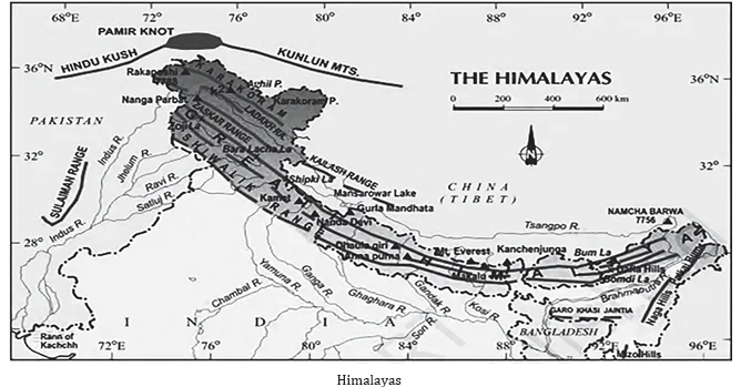
Question 10
Consider the following statements:
Which of the statements given above is/are correct?
(a) 1 only
(b) 2 only
(c) Both 1 and 2
(d) Neither 1 nor 2
ExplanationAns: c
Sub-Theme: Indian Monsoon
Statement 1 is correct: Due to its proximity to the sea, India’s southern region has earlier and longer rainy seasons than its northern region. Rainfall in the northern section of India diminishes as rain-bearing winds cross the western ghats and humidity decreases. The southwest monsoon and the retreating monsoon (northeast monsoon) bring rain to India’s southern region.
Statement 2 is correct: With growing distance from the sea, monsoon rainfall tends to decrease. During the southwest monsoon, Kolkata receives 119 cm, Patna 105 cm, Allahabad 76 cm, and Delhi 56 cm.
Question 11
A particular State in India has the following characteristics:
1. It is located on the same latitude which passes through northern Rajasthan.
2. It has over 80% of its area under forest
3. Over 12% of forest cover constitutes the Protected Area Network in this State.
Which one among the following States has all the above characteristics?
(a) Arunachal Pradesh
(b) Assam
(c) Himachal Pradesh
(d) Uttarakhand
ExplanationAns: a
Sub-Theme: State of India/Map based
Question 12
With reference to the wetlands of India, consider the following statements:
Which of the statements given above is/are correct?
(a) 1 only
(b) 2 only
(c) Both 1 and 2
(d) Neither 1 nor 2
ExplanationAns: a
Sub-Theme: State of India/Wetland
Wetlands:
Statement 1 is correct: The total wetland area in Gujarat is 23.14% of the total wetland of the country.
Statement 2 is incorrect: The area under inland wetlands accounts for 69%, coastal wetlands 27%, and other wetlands (smaller than 2.25 ha) 4%.
| NOTE: Please refer to PYQ 2011 for detailed information on the state of Gujarat. |
2011
Question 1
Westerlies in the southern hemisphere are stronger and persistent than in northern hemisphere. Why?
1. Southern hemisphere has less landmass as compared to northern hemisphere.
2. Coriolis force is higher in southern hemisphere as compared to northern hemisphere.
Which of the statements given above is/are correct?
(a) 1 only
(b) 2 only
(c) Both 1 and 2
(d) Neither 1 nor 2
ExplanationAns: a
Sub-Theme: Wind System
Option (a) is correct: The Southern hemisphere has less landmass as compared to the northern hemisphere. The Coriolis force is the same in both hemispheres.
Landmass in both the Hemispheres:
The latitude and airspeed have a direct correlation with the amount of deflection the air makes. At the equator, the Coriolis force is zero, while maximum at the poles.
Question 2
What could be the main reason/reasons for the formation of the African and Eurasian desert belt?
1. It is located in the sub-tropical high-pressure cells.
2. It is under the influence of warm ocean currents.
Which of the statements given above is/are correct in this context?
(a) 1 only
(b) 2 only
(c) Both 1 and 2
(d) Neither 1 nor 2
ExplanationAns: a
Sub-Theme: Desert
Option (a) is correct: The main reason/reasons for the formation of the African and Eurasian desert belt is because they are located in the sub-tropical high-pressure cells.
Deserts:
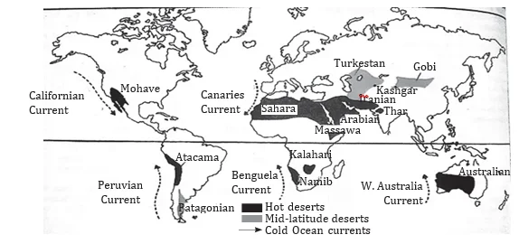
Question 3
The jet aircraft fly very easily and smoothly in the lower stratosphere. What could be the appropriate explanation?
1. There are no clouds or water vapour in the lower stratosphere.
2. There are no vertical winds in the lower Stratosphere.
Which of the statements given above is/are correct in this context?
(a) 1 only
(b) 2 only
(c) Both 1 and 2
(d) Neither 1 nor 2
ExplanationAns: c
Sub-Theme: Layers of Atmosphere
Option (c) is correct: The conditions are practically perfect for flying airplanes since this layer is almost completely devoid of clouds and related weather disturbances. So airplanes fly in the lower stratosphere, sometimes in the upper troposphere where weather is calm.
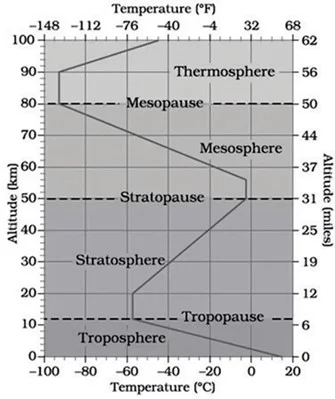
About Stratosphere:
Question 4
The 2004 Tsunami made people realize that mangroves can serve as a reliable safety hedge against coastal calamities. How do mangroves function as a safety hedge?
(a) The mangrove swamps separate the human settlements from the sea by a wide zone in which people neither live nor venture out
(b) The mangroves provide both food and medicines which people are in need of after any natural disaster.
(c) The mangrove trees are tall with dense canopies and serve as an excellent shelter during a cyclone or tsunami
(d) The mangrove trees do not get uprooted by storms and tides because of their extensive roots.
ExplanationAns: d
Sub-Theme: Mangroves
Option (d) is correct: because mangroves function as a safety hedge in preserving ecological stability. The dense tangle of roots allows the trees to withstand storms, cyclones or even the daily rise and fall of tides.
Mangroves:
Question 5
La Nina is suspected to have caused recent floods in How is La Nina different from El Nino?
1. La Nina is characterized by unusually cold ocean temperature in the equatorial Indian Ocean whereas El Niño is characterized by unusually warm ocean temperature in the equatorial Pacific Ocean.
2. El Nino has adverse effects on the south-west monsoon of India, but La Niña has no effect on monsoon climate.
Which of the statements given above is/are correct?
(a) 1 only
(b) 2 only
(c) Both 1 and 2
(d) Neither 1 nor 2
ExplanationAns: d
Sub-Theme: El niño & La-nina
Statement 1 is incorrect: La Nina is characterized by unusually cold ocean temperatures in the Equatorial Pacific, compared to El Nino, which is characterized by unusually warm ocean temperatures in the Equatorial Pacific.
Statement 2 is incorrect: La Nina causes drought in Peru and Ecuador, heavy floods in Australia, high temperatures in Western Pacific, Indian Ocean, off the Somalian coast, and good monsoon rains in India. El Nino: It occurs more frequently than La Nina. This event is not an usual cycle, they are not predictable and occur irregularly at 2 to 7 year intervals. When the coastal waters become warmer in the eastern tropical Pacific (El Niño) it leads to the decrease of atmospheric pressure above the oceans.
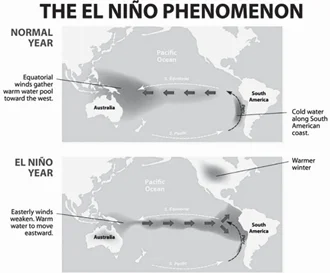
Question 6
The lower Gangetic plain is characterized by a humid climate with high temperature throughout the year. Which one among the following pairs of crops is most suitable for this region?
(a) Paddy and cotton
(b) Wheat and Jute
(c) Paddy and Jute
(d) Wheat and cotton
ExplanationAns: c
Sub-Theme: Major crops in India
Option (c) is correct: The crop suitable to be grown in the lower Gangetic plain, which is characterized by a humid climate with high temperature throughout the year, is Paddy and Jute.
Question 7
Among the following States, which one has the most suitable climatic conditions for the cultivation of a large variety of orchids with minimum cost of production, and can develop an export oriented industry in this field?
(a) Andhra Pradesh
(b) Arunachal Pradesh
(c) Madhya Pradesh
(d) Uttar Pradesh
ExplanationAns: b
Sub-Theme: State of India
About Orchid in Arunachal Pradesh:
The ecological condition and climate variation in Arunachal Pradesh are so favorable that the state holds about 60% of the Indian variety of orchids. Arunachal Pradesh is often called the Orchid State of India.
Question 8
The Brahmaputra, Irrawaddy and Mekong rivers originate in Tibet and flow through narrow and parallel mountain ranges in their upper Of these rivers, Brahmaputra makes a “U’’ turn in its course to flow into India. This “U” turn is due to
(a) Uplift of folded Himalayan series
(b) Syntaxial bending of geologically young Himalayas
(c) Geo-Tectonic disturbance in the tertiary folded mountain chains
(d) Both (a) and (b)
ExplanationAns: b
Sub-Theme: Himalayan River System/Drainage
Brahmaputra makes a “U” turn in its course to flow into India due to the Syntaxial bending of geologically young Himalayas.
About Syntaxial Bends/Syntaxis:
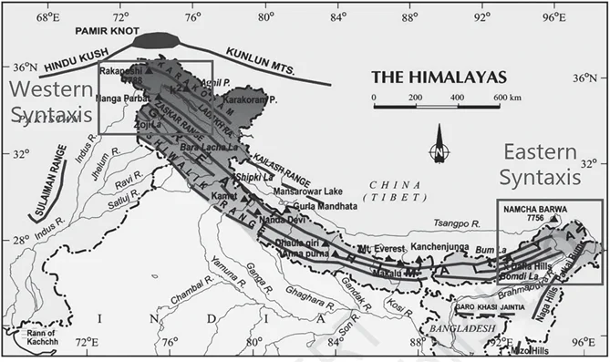
Question 9
A state in India has the following characteristics:
1. Its northern part is arid and semi-arid.
2. Its central part produces cotton.
3. Cultivation of cash crops is predominant over food crops.
Which one of the following states has all of the above characteristics?
(a) Andhra Pradesh
(b) Gujarat
(c) Karnataka
(d) Tamil Nadu
ExplanationAns: b
Sub-Theme: State of India
The state of Gujarat is characterised by its northern part having arid and semi arid climate. Its central part produces cotton and the Cultivation of cash crops is predominant over food crops.
About Gujarat (Gandhinagar):
Question 10
Between India and East Asia, the navigation-time and distance can be greatly reduced by which of the following?
1. Deepening the Malacca straits between Malaysia and Indonesia.
2. Opening a new canal across the Kra isthmus between the Gulf of Siam and Andaman Sea.
Which of the statements given above is/are correct?
(a) 1 only
(b) 2 only
(c) Both 1 and 2
(d) Neither 1 nor 2
ExplanationAns: b
Sub-Theme: Map based
Statement 1 is incorrect: The Malacca Strait is situated between Malaysia and Indonesia and is one of the main shipping lanes. The narrow waterway creates a chokepoint between the Indian Ocean and the Pacific Ocean. Hence, the broadening (not Deepening) the Malacca straits between Malaysia and Indonesia will reduce the navigation time and distance.
Statement 2 is correct: Kra isthmus is the narrowest part of the Malay Peninsula. It is bordered to the west by the Andaman Sea and to the east by the Gulf of Thailand. Thus, opening a new canal across the Kra isthmus between the Gulf of Siam and the Andaman Sea can reduce the navigation time and distance.
Question 11
Two important rivers- one with its source in Jharkhand (and known by a different name in Odisha), and another, with its source in Odisha- merge at a place only a short distance from the coast of Bay of Bengal before flowing into the This is an important site of wildlife and biodiversity and a protected area.
Which one of the following could be this?
(a) Bhitarkanika
(b) Chandipur-on-sea
(c) Gopalpur-on-sea
(d) Simlipal
ExplanationAns: a
Sub-Theme: Physiography of India
About Bhitarkanika National Park
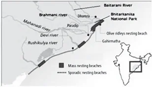
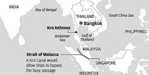

 Books & Magazines
Prelims Wallah (Q&A Bank)
Udaan
Udaan 500+
Budget & Economic Survey
Monthly Current Wallah
Weekly Current Wallah
Editorial Summary
Editorial Q&A Compilation
NCERT Wallah
Prahaar (Mains Wallah)
Marks Booster
Mains Wallah (Q&A Bank)


<div class="new-fform">
</div>
 GS Foundation
 Crash Course
 Combo
Combo Optional Courses
 Degree Program