Context
A recent study published in Communications Earth and Environment journal suggests that the River Nile made the construction of Egypt’s pyramids possible.
Nile River’s Role in Pyramids’ Construction

- Effort in Moving the Great Pyramid Blocks: Scholars estimate that the Great Pyramid of Giza contains roughly 2.3 million individual blocks of stone, each weighing 2.3 metric tonnes on average.
- Pyramid Location: The majority of Egypt’s pyramids are concentrated within a 50-kilometer stretch of desert between Giza and the village of Lisht, located several kilometers away from the Nile River.
Key Highlights from the Study
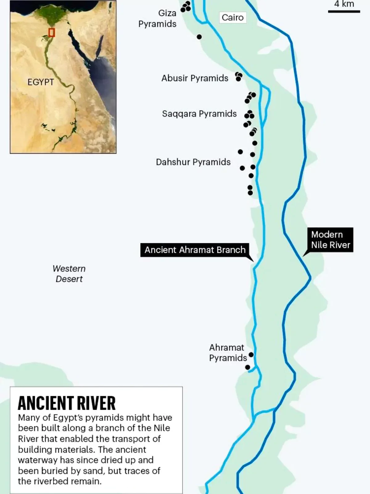
- Extinct Nile Branch Transporting Heavy Material: The study identified segments of a major extinct branch of the Nile, which runs adjacent to the pyramids and could have been used to move heavy material around.
- Mapping of River Branch: The team utilized radar satellite imagery, historical maps, geophysical surveys, and sediment coring—a method employed by archaeologists to extract evidence from samples—to map the river branch.
- This branch, likely buried by sandstorms and a significant drought thousands of years ago, was mapped by their efforts.
Enroll now for UPSC Online Course
Great Pyramid of Giza:
- About: Ancient Egyptian pyramid, is the largest of the three Pyramids of Giza, located on a rocky plateau on the west bank of the Nile River in northern Egypt.
- Construction: It was built by Khufu (Cheops), the second king of Egypt’s 4th dynasty (c. 2543–c. 2436 BCE), and was completed in the early 25th century BCE.
- The Pyramids of Giza are often collectively considered one of the Seven Wonders of the World, and they are the last of the wonders still standing.
|
- Insights into Pyramid Construction: Locating the actual river branch and having the data that shows there was a waterway that could be used for the transportation of heavier blocks, equipment, people, etc helps in explaining pyramid construction.
- Ahramat and Significance: The Nile branch, referred to as the Ahramat by researchers, extended approximately 64 km, with a width ranging from 200 to 700 meters and a depth of 2 to 8 meters.
- The study indicates that several causeways of the pyramids led to the inlets linked to the channel, suggesting they may have functioned as riverine harbors.
- Harnessing the River’s Power: Utilizing “the river’s energy to transport these heavy blocks rather than relying solely on human labor, significantly reduces the effort required.
- This clarifies the dense concentration of pyramids between Giza and Lisht in the challenging Sahara desert.
- Precision in Pyramid Design: Conceptualizing the pyramids required advanced understanding of mathematics and architecture.
- For instance, each side of Giza’s Great pyramid has a precise and consistent gradient of 52 degrees — a testament to both the planning of the architects, and the execution of the workers.
- Organized Worker Settlements: These workers lived in massive, highly organized settlements adjacent to the pyramids.
- The remains of bakeries and piles of animal bones show that the workers were well fed for their labor and the entire enterprise was governed by a centralized authority.
Conclusion
The site holds deeper significance whose construction, decoration, and presence of the structures offer insight into “every facet of life in ancient Egypt.”
![]() 22 May 2024
22 May 2024
