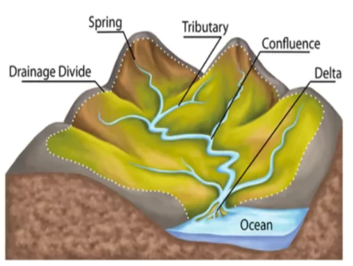
Drainage systems, also referred to as river systems of an area, are the patterns formed by the streams, rivers, and lakes in a particular drainage basin. The Indian drainage system can be distinguished on the basis of discharge of water, size of watershed and on the basis of origin i.e. Himalayan or Peninsular.
Overview of the Classification of Indian Drainage Systems
A. On the Basis of Discharge of Water (Orientations to the Sea)
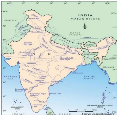
- Types: The Indian drainage system can be grouped into two, the Arabian Sea drainage and the Bay of Bengal drainage.
 Water Divide: Both the drainage systems are separated through the Delhi ridge, the Aravallis and the Sahyadris.
 - The Arabian Sea Drainage: Nearly 23 percent of the drainage area,
- Comprising Indus, Narmada, Tapi, Mahi and Periyar systems.
- discharging their waters in the Arabian Sea.
- The Bay of Bengal Drainage: 77 percent of the drainage area, consisting of Ganga, Brahmaputra, Mahanadi, Krishna, etc.
- It is oriented towards the Bay of Bengal.
B. On the Basis of the Size of the Watershed
- Major River Basins: More than 20,000 sq. km of catchment area; includes 14 drainage basins –
- Example: Ganga, Brahmaputra, Krishna, Tapi, Narmada, Mahi, Pennar, Sabarmati, Barak, etc
- Medium River Basins: Catchment areas between 2,000-20,000 sq. km incorporating 44 river basins –
- Example: Kalindi, the Periyar, the Meghna, etc.
- Minor River Basins: Catchment areas of less than 2,000 sq. km, rivers in the areas of low rainfall.
Enroll now for UPSC Online Course
C. On the Basis of the Mode of Origin: Himalayan Drainage & Peninsular Drainage
1. The Himalayan Drainage
- It comprises three major river basins: Ganga, Indus, and Brahmaputra.
 Characteristics:
 -
- Perennial flow, nourished by both melting of snow and precipitation.
- Perform intensive erosional activity in their upper courses with features: gorges, V-shaped valleys, turbulent rapids, and waterfalls.
- Features in the middle and lower course:
- Erosional Features: Flat valleys, meanders, oxbow lakes, and
- Depositional Features: in their floodplains; braided channels and deltas near river mouths; shift their courses frequently
- Example: River Kosi (sorrow of Bihar)
2. The Peninsular Drainage System
- The Peninsular drainage system is older than the Himalayan one.
- Features: broad, largely-graded shallow valleys, fixed course, absence of meanders and non perennial flow of water
- Water Divide: Western Ghats act as a water divide between rivers discharging their water in the Bay of Bengal and rivers joining the Arabian Sea.
- The Evolution of Peninsular Drainage System: Geological events that influenced present drainage systems of Peninsular India:
-
- Subsidence of the Western Flank: It disrupted the symmetrical plan of the rivers on either side of the original watershed.
- Upheaval of the Himalayas: It caused subsidence on the northern flank of the Peninsular block, leading to trough faulting.
- The Narmada and Tapi rivers flow in these trough faults (rift valleys) and have filled the original cracks with their detritus materials.
- Consequently, there is a lack of alluvial and deltaic deposits in these rivers.
- Tilting of the Peninsular Block from northwest to southeast during the same period. It gave the entire drainage system an orientation towards the Bay of Bengal.
Conclusion
India’s diverse drainage systems, influenced by factors like discharge, watershed size, and geographical origin, play a crucial role in shaping the country’s landscape and ecosystems. From the mighty Himalayan rivers to the ancient Peninsular streams, each contributes to the richness of India’s natural heritage.


 May 4, 2024


 GS Foundation
 Crash Course
 Combo
Combo Optional Courses
 Degree Program