The Himalayas, a majestic mountain range stretching from the Indus River to the Brahmaputra River, dominate the northern landscape of India. Comprising three parallel ranges, the Great Himalayas stand as the highest peaks, boasting an average height of 6,000 meters. These geologically young mountains, with their rugged terrain and expansive valleys, serve as a formidable natural barrier. From the wide expanse of the North Himalayas to the Shiwalik Hills, these iconic ranges shape the geography and culture of the regions it spans.
North South Divisions of the Himalayas
Division of Himalaya: The Himalayas consist of three main parallel ranges: the Great Himalayas (Himadri), Lesser Himalayas (Himachal), and Shiwaliks (Refer Figure)
- The Himalayas represent the loftiest and one of the most rugged mountains in the world.
- Area: Which covers a distance of about 2,400 Km. Their width varies from 400 Km in Kashmir to 150 Km in Arunachal Pradesh.
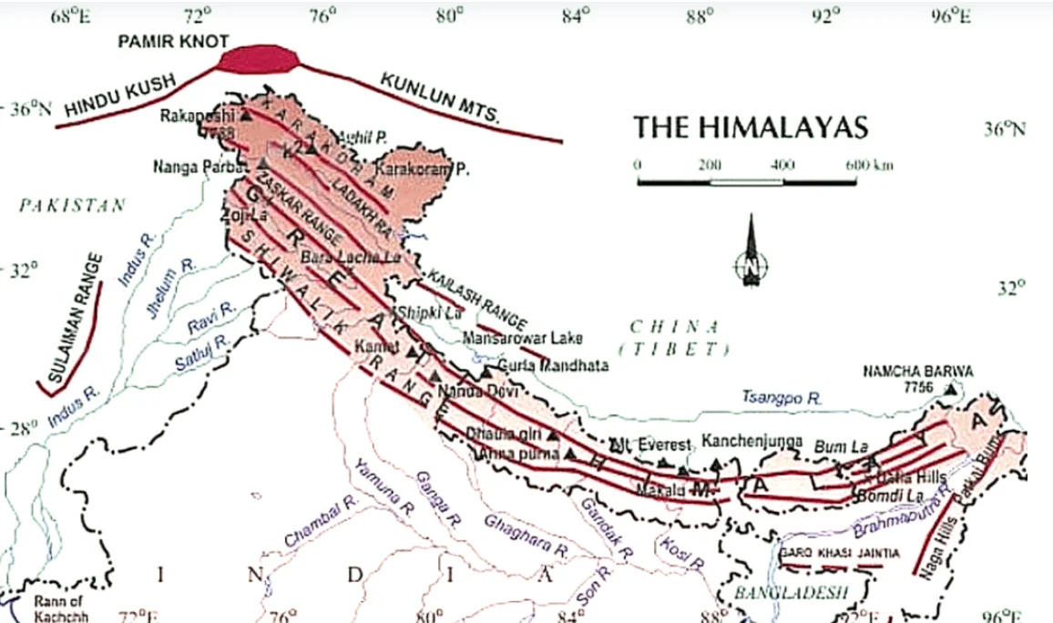
A. Great Himalayas (Inner Himalaya, Central Himalaya or Himadri):
- Location: It is the northernmost or the innermost of all the Himalayan ranges.
- Elevation: Loftiest (average elevation of 6,100 m) and most continuous mountain range in the world.
- Composition: Mainly central crystallines (granites and gneisses) are overlain by metamorphosed sediments.
- Topography: Folds are asymmetrical (steep southern slope and gentle northern slope) giving ‘hogback’ topography.
- Shape: is convex to the south, terminates abruptly at Nanga Parbat (north-west) and Namcha Barwa (north-east).
- Peaks: The highest is Mount Everest; other important peaks in descending order of altitude – Kanchenjunga, Lhotse, Makalu, Dhaulagiri, Manaslu, Nanga Parbat, Annapurna, Gosainthan or Shisha Pangma.
- Some of the important peaks between 7,100 and 8,000 m elevation – Nanda Devi, Kamet, Namcha Barwa, Gurla Mandhata, Badri Nath, Trisul, etc
- Passes: Jammu and Kashmir – Burzil Pass and Zoji La;
- Himachal Pradesh – Bara Lacha La and Shipki La;
- Uttarakhand – Thaga La, Niti Pass and Lipu Lekh; Sikkim – Nathu La and Jelep La
| Namcha Barwa: situated in south east Tibet; Nanda Devi (part of Kumaon Himalayas) is the third highest peak in India. [UPSC 2023] |
B. Middle or Lesser Himalayas (Himachal or Lower Himalayas)
- Location: It is located between Great Himalayas (north) and Shiwaliks (south).
- Elevations: vary from 3,500 to 4,500 m above sea level and have steep southern slopes and more gentle northern slopes (typical hogback look).
- Ranges: Pir Panjal, Dhaola Dhar, Mussoorie Range, Nag Tiba, Kumaon Range and Mahabharat Lekh.
- Pir Panjal Range: extends from the Jhelum river to the upper Beas river and contains mostly volcanic rocks.
- Passes: Pir Panjal Pass, Golabghar Pass and Banihal Pass (Jammu Srinagar Highway). The Kishanganga, the Jhelum and the Chenab cut through it.
- Dhauladhar Range: has hill stations like Dalhousie, Dharamshala, and Shimla,
- Mussoorie Range: has Mussoorie, Nainital, Chakrata and Ranikhet
- This range consists of the famous valley of Kashmir; the Kangra Valley (strike valley and extends from the foot of the Dhauladhar Range to the south of Beas) and Kullu Valley (transverse valley, in the upper course of the Ravi) in Himachal Pradesh.
- Miri, Abor and Mishmi hills represent the lower Himalayas.
- Himachal: also known as lesser Himalaya is the most rugged mountain system.
C. Shiwaliks (Outer Himalayas)
- Outermost Edge: The outermost range of the Himalayas.
- Average Elevation: It has an altitude ranging from 900 to 1100m.
- Characteristics: Flat scarps, anticlinal crests and synclinal valleys
- Origin: Shiwaliks are formed of Mio Pleistocene sands, gravels and conglomerates brought by the Himalayas rivers.
- As Shiwalik Hills were formed after the formation of the Himalayas, they obstructed the courses of the Himalayan rivers and formed temporary lakes where debris by these rivers was deposited.
- Duns: The lakes were drained away leaving behind plains called ‘duns’ in the west and ‘duars’ in the east.
- The longitudinal valleys lying between the lesser Himalayas and the Shiwaliks are known as Duns.
- Examples: include Dehradun, Kotli Dun, and Patli Dun.
- Southern Slope: Shiwaliks are marked by the absence of forest cover in Punjab and Himachal Pradesh and are highly dissected by several seasonal streams locally called Chos.
Conclusion
In India’s geography, the North-South division of the Himalayas is split into three parts: the Greater, Middle, and Siwaliks HImalayas. These mountains are strong and remarkable. They have existed for a long time and have witnessed many events. They have a significant impact on their surroundings, influencing the weather and the way people live. And they will continue to be important for a long time to come.


 May 4, 2024


 GS Foundation
 Crash Course
 Combo
Combo Optional Courses
 Degree Program