Introduction
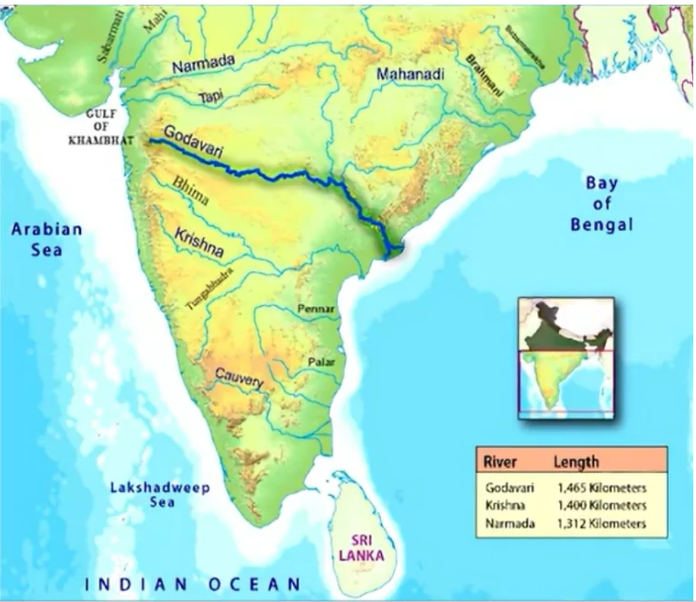
The Peninsular drainage system, older than the Himalayan one, shapes the landscapes of India with its broad valleys and fixed courses. With the Western Ghats acting as a divide, rivers flow either into the Bay of Bengal or the Arabian Sea, showcasing the region’s geological history.
The Evolution of the Peninsular Drainage System
- Geological events that influenced present drainage systems of Peninsular India:
- Subsidence of the Western Flank: It disrupted the symmetrical plan of the rivers on either side of the original watershed.
- Upheaval of the Himalayas: It caused subsidence on the northern flank of the Peninsular block, leading to trough faulting. The Narmada and Tapi rivers flow in these trough faults (rift valleys) and have filled the original cracks with their detritus materials. Consequently, there is a lack of alluvial and deltaic deposits in these rivers.
- Tilting of the Peninsular Block: from northwest to southeast during the same period. It gave the entire drainage system an orientation towards the Bay of Bengal.
- Features: broad, largely-graded shallow valleys, fixed course, absence of meanders and non perennial flow of water
- Water Divide: Western Ghats act as a water divide between rivers discharging their water in the Bay of Bengal and rivers joining the Arabian Sea.
Enroll now for UPSC Online Course
River Systems of the Peninsular Drainage:
A. East Flowing Rivers
- Delta Formation: These rivers make deltas at their mouths.
- Small east flowing rivers are:
- Subarnarekha (Rises from Ranchi Plateau),
- Rushikulya (Origin:Nayagarh hills)
- Baitrani (Rises from Garhjat hills),
- Brahmani (confluence of the Sankh and South Koel rivers; origin of both these rivers is Chota Nagpur plateau),
- Vamsadhara and Nagavali river(Origin: Eastern Ghat-Odisha),
- Penner, Palar and the Vagai. [UPSC 2021]
- Mahanadi
- Origin: Raipur district of Chhattisgarh.
- Drainage Basin: 53% in Madhya Pradesh and Chhattisgarh; remaining 47% in Odisha.
- Tributaries: Left Bank – Sheonath, Hasdo, Mand; Right Bank – Tel, Jonk, Ong.
- Godavari
- Origin: Nasik district of Maharashtra.
- Largest river system in the Peninsular drainage; also called Dakshin Ganga.
- Drainage Basin: 49% in Maharashtra, 20% in Madhya Pradesh and Chhattisgarh, and rest in Andhra Pradesh.
- Tributaries: Left Bank – Penganga, Indravati, Pranhita (formed by confluence of Wainganga and Wardha) ;
-
- Right Bank – Manjra, Maner.[UPSC 2015]
- Krishna
- Origin: Mahabaleshwar in the Sahyadri (Western Ghats).
- Tributaries: Right Bank– Koyna, Panchganga, Ghatprabha, Malaprabha, Tungabhadra(Hampi is located near the river); Left Bank– Bhima, Dindi, Musi, Munneru.
- Catchment Area: 27% in Maharashtra, 44% in Karnataka, and 29% in Andhra Pradesh and Telangana.
- Kolleru Lake: lies between the deltas of Godavari and Krishna. It is not directly fed by the Krishna River [UPSC 2023]
|
- Kaveri
-
- Origin: Brahmagiri Hills (Karnataka).
- Drainage Basin: 3% in Kerala, 41% in Karnataka, and 56% in Tamil Nadu.
- Tributaries: Left Bank – Hemavati, Shimsha; Right Bank – Kabni, Bawani, Noyyal, Amaravati.
- It makes the second biggest waterfall in India known as Shivasamudram Falls (Karnataka); Tiruchirapalli is located along the River.
B. West Flowing Rivers
- Estuary Formation: These rivers make estuaries at their mouth
- Narmada
- Origin: Amarkantak plateau
- Course: Flows through a rift valley between Satpura (South) and Vindhyan Range (north); meets the Arabian sea south of Bharuch [UPSC 2013]
- Dhuandhar Falls near Jabalpur (MP); Sardar Sarovar dam
- Tributaries: Left Bank: Tawa River; Right Bank: Barna River, Kolar River
- Tapi
- Origin: Betul (Madhya Pradesh), Satpura range
- Drainage Basin: 79% in Maharashtra, 15% in Madhya Pradesh, and 6% in Gujarat.
- Luni
- Origin: near Pushkar in Rajasthan in two branches, i.e. the Saraswati and the Sabarmati that join together.
- Drains into the Rann of Kachchh (Gujarat)
- The entire river system of the Luni is ephemeral (seasonal flow)
- Sabarmati: originates in the Aravalli Range and drains into the Gulf of Khambhat (Arabian Sea).
- Mahi River originates from Vindhyas in Dhar (Madhya Pradesh) and after flowing through Rajasthan, enters Gujarat and falls into the Arabian Sea.
- Periyar , Pamba, and Bharathapuzha
- Rivers of Kerala; Bharathapuzha is the longest river and Periyar is the second largest river of Kerala; Pamba River falls in Vembanad lake.
- Other West flowing rivers: Shetruniji, Bhadra and Dhadhar (Gujarat); Vaitarna River (Trimbak hills; Nasik, Maharashtra); Mandovi and Zuari (Goa); Kalinadi (falls in Karwar Bay), Bedti and Shravasti (Karnataka).
- Gersoppa (Jog) fall is on Shravasti river.
Enroll now for UPSC Online Classes
- 71% of the world’s surface is covered with water, but 97% of that is salt water. Of the 3% that is available as freshwater, three-quarters of it is trapped as ice.
|
Conclusion
The Peninsular drainage system, moulded by geological events, highlights a diverse network of rivers flowing through India’s heartland. From the mighty Godavari to the ephemeral Luni, each river tells a tale of the land’s evolution and sustains life across its path.


 May 6, 2024


 GS Foundation
 Crash Course
 Combo
Combo Optional Courses
 Degree Program