According to the Assam State Disaster Management Authority, floods have claimed more than 50 lives and displaced 3,60,000 people this year.
- More than 40,000 hectares of crop area have been affected and large parts of Dibrugarh and Guwahati regions of Assam are under water.
About Flood
Floods are the most frequent type of natural disaster and occur when an overflow of water submerges land that is usually dry.
- Caused by: Floods are often caused by heavy rainfall, rapid snowmelt or a storm surge from a tropical cyclone or tsunami in coastal areas.
- Types of Floods: There are following three common types of floods:
- Flash Floods: These are caused by rapid and excessive rainfall that raises water heights quickly, and rivers, streams, channels or roads may be overtaken.
- River Floods: These are caused when consistent rain or snow melt forces a river to exceed capacity.
- Coastal Floods: These are caused by storm surges associated with tropical cyclones and tsunami.
Enroll now for UPSC Online Course
Concerning Impacts and Statistics of Floods in India
Floods can cause widespread devastation, resulting in loss of life and damages to personal property and critical public health infrastructure.
- According to the World Health Organization (WHO), between 1998-2017, floods affected more than 2 billion people worldwide.
- According to the National Disaster Management Authority (NDMA), on an average every year, 75 lakh hectares of land is affected, 1600 lives are lost and the damage caused to crops, houses and public utilities is Rs. 1805 crores due to floods.
- Higher Cause of Death:
- Drowning: It accounts for 75% of deaths in flood disasters. Drowning risks increase with floods particularly in low- and middle-income countries where people live in flood prone areas and the ability to warn, evacuate, or protect communities from floods is weak or only just developing.
- Multiple Factors: Deaths also result from physical trauma, heart attacks, electrocution, carbon monoxide poisoning or fire associated with flooding. Often, only immediate traumatic deaths from flooding are recorded.
- Floods can also have medium- and long-term health impacts, including:
- Water- and vector-borne diseases, such as cholera, typhoid or malaria
- Injuries, such as lacerations or punctures from evacuations and disaster cleanup
- Chemical hazards
- Mental health effects associated with emergency situations
- Disrupted health systems, facilities and services, leaving communities without access to health care
- Damaged basic infrastructure, such as food and water supplies, and safe shelter
Assam’s Vulnerability to Floods
Assam’s vulnerability stems from a complex combination of hydrological and climatic factors.
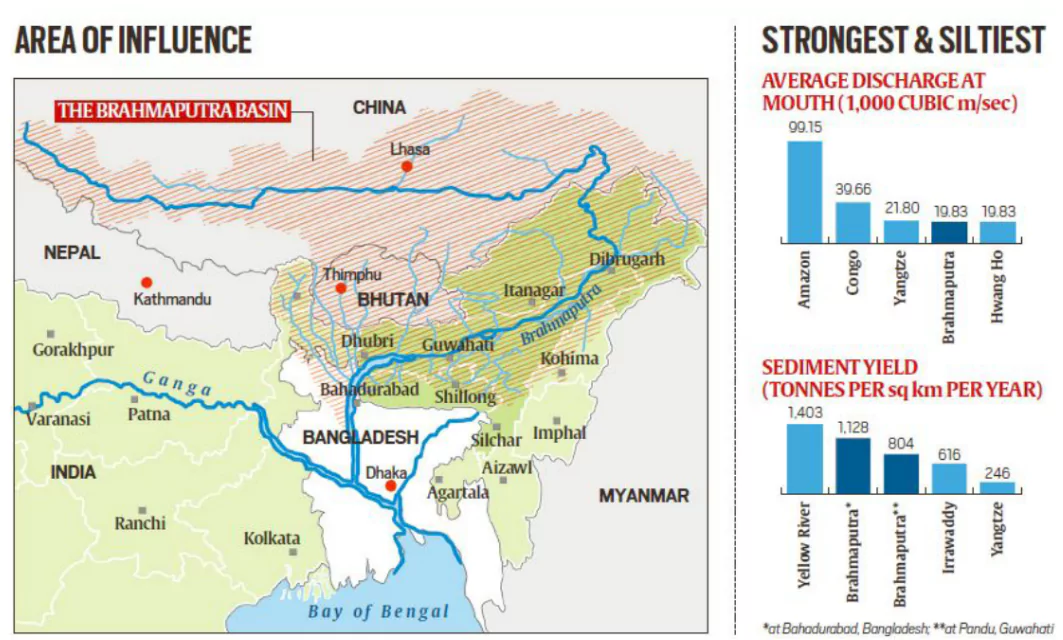
- Presence of Large Number of Rivers: Assam has more than 120 rivers, several of which originate from the hills and mountains of extreme rainfall hotspots in Arunachal Pradesh and Meghalaya as well as in China and Bhutan.
- Example: Brahmaputra river flows through Assam over a length of around 650 km with an average width of 5.46 km, making it the principal river that crisscrosses the floodplains.
- Coming from the Kailash range (high elevation), the river gets highly sedimented by the time it enters Assam (low elevation).
- Due to this flattening of the slope, there is a sudden drop in velocity and the river deposits huge quantities of sediment and other debris collected from hilly terrains on the riverbed, raising its level.
- During summers, the sedimentation increases as soil erodes with the melting of glaciers.
- A Large Flood Prone Region: The flood prone area of Assam as assessed by the Rashtriya Barh Ayog is about 39.58 %. This is about 9.40% of the total flood prone area of India.
- The flood prone area of India as a whole stands at about 10.2 % of the total area of the country, which signifies that the flood prone area of Assam is four times the national mark of the flood prone area of the country.
- Geographical Factor: Guwahati is a bowl-shaped lowland, susceptible to water logging.
- Rainwater from neighbouring Meghalaya and the surrounding hills causes flash floods.
- Outdated Structures: Historical flood control structures are now outdated and not effective in current conditions. Like in most Indian cities, Guwahati’s drainage system is in disrepair.
- The Monsoon Factor: The monsoon is intense in the Northeast. According to the State Disaster Management Authority, annual rainfall averages around 2900 mm with maximum precipitation in June and July.
- The Water Resources Ministry of Assam states that 85% of the annual rainfall in the Brahmaputra basin takes place during the monsoon months.
- Also, Assam gets a good amount of rainfall in April and May due to thunderstorm activities which account for flooding during heavy rain in June, when the soil is already saturated.
 Erosion of Riverbank: Damages caused due to erosion runs into several hundred crores every year. Bank erosion by the rivers has been a serious issue since the last six decades as more than 4.27 Lakh Hectares of land was already eroded away by the river Brahmaputra and its tributaries since 1950, which is 7.40 % of area of the state.
- Soil erodes and rivers expand as it gets more area and this results in flooding. This erosion of the land alongside rivers has emerged as a serious problem for Assam.
- The width of Brahmaputra has increased up to 15 km due to bank erosion at some places in Assam.
- Human Intervention:
- Construction of Embankments: Construction of embankments first started in Assam in the 1960s to control floods. However, six decades later, most of these embankments have either outlived their utility or are in bad condition. Many others were washed away.
- Population Boom: Population boom has put more pressure on the State’s ecology.
- Example: According to a report by the Brahmaputra Board, the population density of Brahmaputra valley has highly increased as per the 2011 census.
- The board under the Ministry of Jai Shakti monitors the Brahmaputra and Barak Valley and covers States under the Brahmaputra basin.
- Climate Change: Floods are also increasing in frequency and intensity, and the frequency and intensity of extreme precipitation is expected to continue to increase due to climate change.
- As per a State Government Report, the extreme rainfall events will increase by 38%.
- Example: Melting of glaciers due to rising temperatures means rivers from the Himalayas will be carrying more water and sediment even before they enter Assam where smaller rivers are swelled up due to incessant rainfall.
- Impact of Other Disasters: Assam and some other parts of the northeastern region are prone to frequent earthquakes, which causes landslides, resulting in formation of a lot of debris in the rivers, causing the river bed to rise and leads to floods.
- Lack of State-of-the-art Warning Systems: In 2021, a parliamentary panel asked the Centre to set up modern weather stations in the upstream catchment of the Northeast’s dams and install sirens to alert people downstream of floods. However, the region continues to lack state-of-the-art warning systems.
- Missing on Actions: Solutions such as tapping into the knowledge systems of indigenous people to build flood-resistant houses, dredging rivers, arresting erosion or even building more resilient embankments have either remained on paper or have not been adequately implemented.
- Other Factors Worsened the Flood Situation: Deforestation, Hill Cutting, Encroachments, Destruction of Wetlands, Lack of Drainage System in the State, Unplanned Urban Growth, Construction of Dams, Hydro Projects, Irrigation Projects, etc.
Check Out UPSC CSE Books From PW Store
Steps Taken by the Indian Government to Manage Floods
Following actions have been taken in the direction to manage the floods in India:
- National Flood Management Programme (1954): In this program, structural and non-structural methods had been adopted depending on the nature of the problem, geographical conditions and available resources.
- Rashtriya Barh Ayog (National Flood Commission, 1976): Set up by the Ministry of Agriculture and Irrigation with the purpose to evolve an integrated and scientific approach to the flood control problems and prepare a national plan to fix the priorities.
- National Commission for Water Resources (1999): It suggested that storage dams and embankments provide effective protection to flood-prone areas and an urgent need to enact the flood plain zoning Act.
- National Water Policy (2012): Formulated by the Ministry of Jal Shakti with the objective to take cognizance of the existing flood situation and to propose a plan of action from the national perspective.
- It suggested that through reservoir operation, the flood cushion can be set up to reduce the trapping of sediment during the flood season.
- National Hydrology Project (2016): The project gathers hydro-meteorological data which will be stored and analysed on a real-time basis and can be accessed by any user at the State, District, and Village level.
- Flood Management and Border Areas Programme (FMBAP, 2017-20): It was implemented throughout the country for effective flood management, and soil and anti-sea erosion.
- The catchment area treatment helps in the reduction of sedimentation load into rivers.
- Flood Management by Establishing Dams: Various dams like Damodar Valley Corporation (DVC), Bhakra Dam across Sutlej, the Hirakud Dam on the Mahanadi, etc. are constructed to control floods.
- Flood management by Establishing a National Disaster Team: Various National disaster teams are formed to manage the approach of floods and excavate the people and take them to the shelter home where they are given food, water, and clothes until the situation comes under control.
- Administrative / Non-structural Measures: The administrative methods endeavour to mitigate the flood damages by:
- Facilitating timely evacuation of the people and shifting of their movable property to safer grounds by having advance warning of incoming flood i.e. flood forecasting, flood warning in case of threatened inundation.
- Discouraging creation of valuable assets/settlement of the people in the areas subject to frequent flooding i.e. enforcing flood plain zoning regulation.
- Flood Plain Zoning: It aims at demarcating zones or areas likely to be affected by floods of different magnitudes or frequencies and probability levels, and specify the types of permissible developments in these zones, so that whenever floods actually occur, the damage can be minimised, if not avoided.
- Flood Proofing: It was adopted in India in the past, consisting in raising a few villages above pre-determined flood levels and connecting them to nearby roads or highlands.
Way Forward
To combat the threat and challenge of floods, following measures are suggested:
- Early Warning Systems: Earlier experiences offer several valuable lessons in adaptation to floods. At the same time, climate-imposed exigencies demand new paradigms of early-warning and response systems and securing livelihoods and economies.
- Information Communications: It should be ensured that more credible information is made available so that preparedness can be improved and residents can be alerted.
- Time has come to modernise the flood warning systems by installing advanced weather stations and sirens, as suggested by a parliamentary panel in 2021.
- Improved Infrastructure and Drainage systems: Investing in well-designed and adequately maintained infrastructure, including drainage systems, can help manage and redirect excess water during heavy rainfall events.
- Construction of Sluice Gates: Sluice Gate’s valves are designed to seal in one direction and commonly are used to control water levels and flow rates in rivers and canals.
- They also are used in wastewater treatment plants.
- Example: Sluice Gates should be constructed on tributaries of Brahmaputra and other rivers and would prove to be an effective step.
- Collaborative Action: Enhance collaboration between state and central governments to ensure resources and efforts are adequately directed toward sustainable flood management solutions.
- People’s Involvement: There is a need to integrate indigenous knowledge to construct flood-resistant housing and infrastructure.
- Also, the rapid transformation in rainfall characteristics and flooding patterns demand building people’s resilience.
- Sustainable Land Management: Construction projects that impede the movement of water and sediment across the floodplain must be reconsidered.
- Encouraging responsible land management practices, such as avoiding excessive excavation and deforestation, can help preserve the natural landscape and prevent soil erosion.
- Conduct regular dredging of rivers to manage sediment and improve flow.
- Also, there is a need to arrest soil erosion along riverbanks to stabilise landscapes and reduce sediment load in rivers.
- Need to follow major Recommendations of Task Force 2004 on Flood Management/ Erosion Control:
- Expansion of Role: Expanding the role of the Central Govt. in the Flood control sector. The flood control schemes should be funded through a Centrally Sponsored Scheme in the ratio of 90% Central and 10% State from the present 75:25.
- More Investment: Earmarking funds in the State sector as Additional Central assistance for maintenance of embankments.
- The Central Government may consider funding the flood control component of the reservoir projects.
- Strengthening of Flood Management Organisation of the Central Water Commission: By restoring the post of Member (Floods) abolished earlier and redeployment of posts of associated functionaries in order to have policy formulation and coordination amongst various agencies.
- Others: Planting vegetation to retain excess water, terrace slopes to reduce slope flow, and building alluviums (man-made channels to divert water from flooding), construction of dykes, dams, reservoirs or holding tanks to store extra water during flood periods.
Enroll now for UPSC Online Classes


 8 Jul 2024


 GS Foundation
 Crash Course
 Combo
Combo Optional Courses
 Degree Program