Context: This article is based on the news “IIT Delhi team makes first hi-res landslide risk map for India” which was published in the Hindu. Indian Institute of Technology Delhi has made the first high-resolution landslide susceptibility map for India and the map data is available for free.
| Relevancy for Prelims: National Landslide Susceptibility Map, Landslide Atlas of India, Landslide Early Warning System, Indian Space Research Organisation (ISRO), Indian Meteorological Department (IMD), and Disaster Management In India.
Relevancy for Mains: Landslides in India: Overview, Causes, Types, Case Study, and Way Forward. |
National Landslide Susceptibility Map: Background
- In late 2023, torrential rain during the northeast monsoon triggered heavy floods and landslides in multiple States in India, killing hundreds of people.
- It highlights the need for a national landslide susceptibility map to identify the most dangerous areas and help allocate resources for mitigation strategies better.
About National Landslide Susceptibility Map
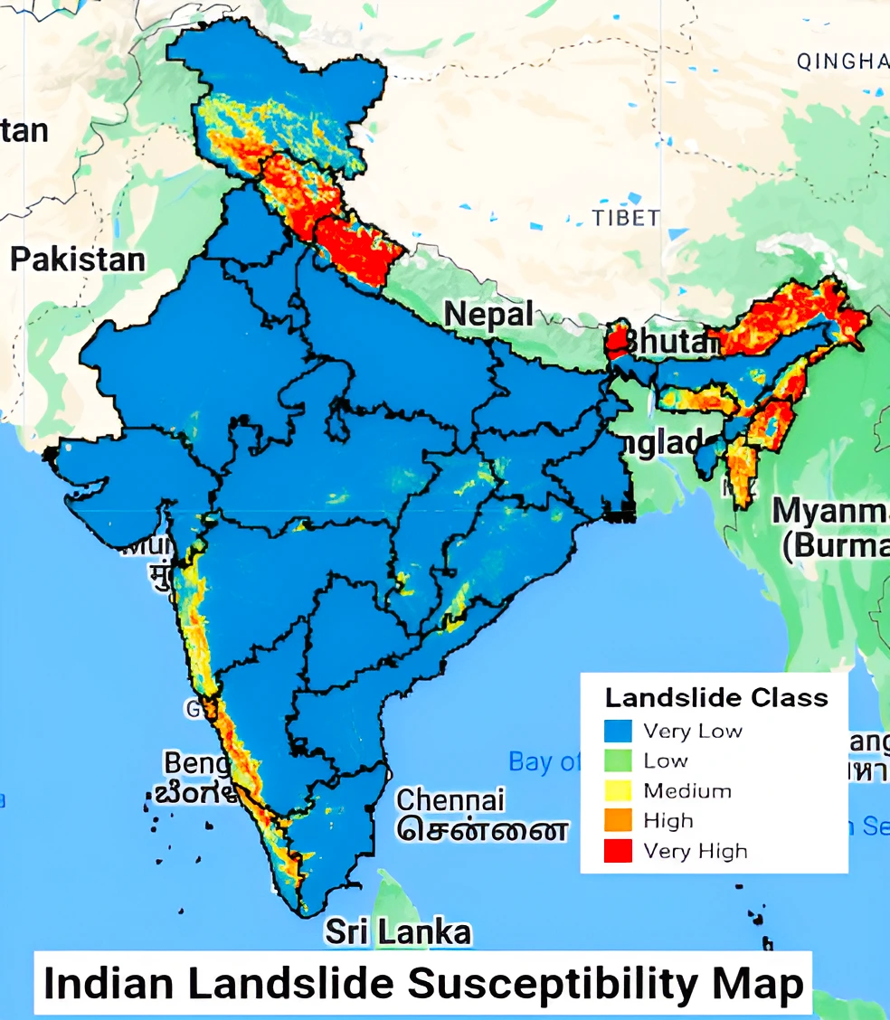
- The team from IIT Delhi built a national landslide susceptibility map that uses the latest data and data collection and mapping techniques.
- High Resolution: The map, could plot the susceptibility at a resolution of 100 m.
- Identified Region: The map acknowledged some high landslide susceptibility, like parts of the foothills of the Himalayas, the Assam-Meghalaya region, and the Western Ghats.
- New Insight: It also revealed some previously unknown places with high risk, such as some areas of the Eastern Ghats, north of Andhra Pradesh.
Ensemble learning: It is a machine learning technique that enhances accuracy and resilience in forecasting by merging predictions from multiple models.
- It aims to mitigate errors or biases that may exist in individual models by leveraging the collective intelligence of the ensemble.
|
- Leveraging Ensemble Machine Learning Technology: Ensemble machine learning is when multiple machine learning models are used together to average out an oversized impact from any one model.
- Factors Used: They collected information on factors like soil cover, number of trees covering the area, distance from roads or mountains, etc.
- They used GeoSadak, an online system with data on the national road network in India, displaying data on roads located outside cities.
About Landslides in India
- Definition of Landslide: It is a movement of a mass of rock, earth, or debris down a slope.
- Landslide Prone Regions: The regions with fewer trees, closer to road-building activity, and steeper local slopes are more unstable and prone to landslides.
Causes of Landslides in India
- They can occur on many types of terrain given the right conditions of soil, rock, geological structure, drainage, and slope.
- Natural Causes: Rainfall, undercutting of slopes due to flooding or excavation, earthquakes, snowmelt, etc.
- Anthropogenic Causes: Overgrazing by cattle, terrain cutting and filling, excessive development, etc.
- For example, land use changes lead to deforestation and exposure of slopes cut for the development of a key railway project likely contributed to a deadly landslide in the western Manipur in 2022.
Types of Flows
- Debris Flow: It is a form of rapid mass movement in which a combination of loose soil, rock, organic matter, and slurry flows downslope. They are commonly caused by intense precipitation or rapid snow melt.
- Earth Flow: It is a downslope viscous flow of fine-grained material saturated with water.
- Mudflow: A mudflow is a wet or viscous fluid mass of fine and coarse-grained material that flows rapidly along drainage channels.
- Creep: Creep is the slow, steady, downward movement of material under gravity that occurs in a large area.
Must Read: Interconnected Disaster Risks Report 2023 – UNU-EHS
Overview of Landslides in India
- Increasing Landslides in India: Over the past 50 years, the landslides seem to have increased in magnitude and frequency due to human activities.
- For instance, India has improved and expanded its road network in mountainous states under the national Bharatmala Pariyojana (“Road to Prosperity”) initiative.
- However, the Copernicus organization recorded more than one landslide per road kilometer along the NH-7 between Rishikesh and Joshimath.
ISRO’s Landslide Atlas of India Findings
- Global Standing in Landslide Risk: India is among the top five landslide-prone countries globally, where at least one death per 100 sq km is reported in a year.
- Rainfall variability Pattern: Primary cause of landslides with the Himalayas and the Western Ghats remaining highly vulnerable.
- Land Area Prone to Landslide: Excluding snow-covered areas, approximately 12.6% of the country’s geographical land area.
- Regional Variability: 66.5% of the landslides are reported from the North-western Himalayas, about 18.8% from the North-eastern Himalayas, and about 14.7% from the Western Ghats.
Landslides in the Himalayas
- They have been observed to be the most frequent landslide incidents, because the Himalayas are a comparatively young mountain system and the rock structure is still weak and fragile.
About Landslide Atlas of India
- Landslide Atlas of India: It is a detailed guide identifying landslide hotspots in the country.
- Released by: Indian Space Research Organisation (ISRO).
- ISRO’s National Remote Sensing Centre (NRSC) has created a database of India’s landslide-prone regions based on events from 1998 – 2022.
- Regional Focus: The database contains regions primarily along the Himalayas and the Western Ghats.
- Satellite Imaging: In addition to aerial images, high resolution satellite images captured using:
- Cameras: Indian Remote Sensing (IRS-1D) PAN and IRS LISS-III.
- Satellites: ResourceSat-1 and 2, etc., were used to study the landslides over the past 25 years.
|
Major Causes of Landslides in India
External Causes of Landslides
- Undercutting of the foot of the hill slope due to river erosion, quarrying, excavation for canals and roads, etc.
- Increase in external loads such as buildings, reservoirs, highway traffic, stockpiles of rocks, accumulation of alluvium on slopes, etc.
- Increase in unit weight of slope material due to increased water content.
- Vibrations due to earthquakes, blasting, traffic, etc., causing an increase in shearing stresses.
- Anthropic changes caused by deforestation
- Undermining caused by tunneling, collapse of underground caverns, seepage erosion, etc.
Internal Causes of Landslides
- Increase in pore water pressure.
- Reduction in cohesive strength caused by progressive lateralization.
- Cracks due to alternate swelling and shrinkage from tension.
- Presence of faults, joints, bedding planes, cleavage, etc., and their orientation.
- Freezing and thawing of rocks and soils.
- Material properties such as compressive strength, shearing strength, etc., of earth material.
Impacts of Landslides
- Economic Impacts: Landslides cause extensive damage to houses, roads, buildings, forests, plantations, and agricultural fields.
- According to the Department of Revenue of the Himachal government, Himachal Pradesh has an estimated cost of damage from flood and landslides at over Rs 3738 crore due to the widespread destruction caused by torrential rains during the monsoon from June 24 to July 14 in 2023.
- Social Impacts: In landslide disasters, casualties may not be widespread, except when associated with earthquakes or volcanoes. Fatalities are more where population pressure has prompted settlements in areas vulnerable to landslides.
- According to the Statement of Climate of India 2022 released by the Indian Meteorological Department (IMD), heavy rain, floods and landslides claimed 835 lives in India in 2022.
- Kerala landslide 2021: More than 20 people died in landslides and flooding triggered due to heavy rain. According to India’s National Emergency Response Centre (NERC), 5,223 people have been displaced and moved to 163 temporary relief camps.
- Mumbai Landslides 2021: At least 30 people died in Mumbai suburbs after several houses collapsed when heavy rain triggered landslides.
- Environmental Impact: Landslides result in habitat destruction, soil erosion, and water pollution, altering ecosystems and jeopardizing biodiversity. The soil displacement contributes to increased erosion, negatively impacting water quality and aquatic life.
Case Study: Joshimath Sinking
- Joshimath is a hilly town located on the Rishikesh-Badrinath National Highway (NH-7) in the Chamoli district of Uttarakhand.
- It is built on the deposits of an old landslide, which means that the slopes can be destabilised even by slight triggers.
- The town is also in Zone V, which, as per India’s seismic zonation scheme, denotes the highest risk.
- It is overly burdened with structures built without any regard for the land’s load bearing capacity.
Reasons for Joshimath Sinking
- Unplanned construction, booming tourism, and government-funded mega infrastructure and power projects.
- Improper drainage systems.
- The 6-km Helang-Marwari bypass (part of the 825-km Char Dham highway expansion project), being built by the Border Roads Organisation (BRO), is under scrutiny for weakening slopes and further destabilising the local topography.
- Locals point to the National Thermal Power Corporation’s Tapovan Vishnugad hydropower project as an exacerbated crisis.
|
About National Disaster Management Authority (NDMA)
- About NDMA: As per the Disaster Management Act, 2005 the National Disaster Management Authority (NDMA), is a statutory and apex body under the Chairmanship of the Prime Minister.
- Mandate: NDMA is mandated to lay down the policies, plans, and guidelines for disaster management to ensure timely and effective disaster response.
National Disaster Management Guideline on Management of Landslides and Snow Avalanches.
- Hazard, Vulnerability & Risk Assessment: Identify areas prone to landslide hazards and assess resources at risk
- Early Warning Systems: Continuous monitoring of movements, stress development, and timely data transmission
- Investigations for Risk Assessment: Multi-disciplinary investigations for comprehensive risk assessment leading to formulation of standards to effectively mitigate the impact of landslides
|
Way Forward
- Landslide Monitoring involves deploying sensors, satellite imagery, and ground-based instruments to detect ground movement and potential landslide precursors.
- For this, the National Highways Authority of India (NHAI) is planning to install a landslip detection system on the Gap Road stretch of the Kochi-Dhanushkodi National Highway in Munnar to warn the authorities about landslips.
- Landslip Detection System: It was developed by the Indian Institute Of Technology-Mandi (IIT-Mandi), the Indian Army, and the Defence Research and Development Organisation (DRDO).
- Generation of User-Friendly Landslide Hazard Maps: It covers aspects of reliability and validation of landslide zoning maps in Indian scenarios and landslide zoning by making use of advanced tools such as Unmanned Aerial Vehicles (UAV), Terrestrial Laser Scanners, and very high-resolution Earth Observation (EO) data.
- Following International Best Practices: Brazil’s SNAKE System: The SNAKE System is the Landslide Early Warning System (LEWS), epitomizing advancements in digital monitoring, forecasting, and alert mechanisms.
- Creation of a Special Purpose Vehicle (SPV) for Landslide Management: An expert professional group should be constituted at the national level to
- Study and decide on risk mitigation strategy for landslides.
- To recommend permanent fixing of the identified landslide hotspots.
- Awareness Programmes: They aim towards a culture of awareness generation and preparedness so that people in society become alert and aware in case of an emergency or take preventive measures before disaster strikes.


 8 Jan 2024


 GS Foundation
 Crash Course
 Combo
Combo Optional Courses
 Degree Program