Context
The Centre has been pushing cell phone makers in India to make their instruments compatible with NavIC.
More about the news:
- The Navigation with Indian Constellation (NavIC) will soon be integrated into Aadhaar enrolment devices according to the Department of Space (DoS).
- The department has facilitated successful conduction of field trials, and is providing technical expertise in finalisation of procurement specification of the devices
 Currently the Aadhaar enrolment kits that are used to collect and verify personal details are linked to the American Global Positioning System (GPS).
- The process of making the devices compatible with NavIC will involve hardware alterations.
About NavIC
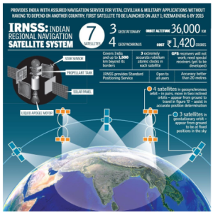
- ISRO has established a regional navigation satellite system (NavIC) to meet the positioning, navigation and timing requirements of the nation.
- It was erstwhile known as Indian Regional Navigation Satellite System (IRNSS).
- NavIC is designed with:
- Three satellites placed in geostationary orbit. Four satellites are placed in inclined geosynchronous orbit with equatorial crossing.
- The ground network: It consists of control centre, precise timing facility, range and integrity monitoring stations, etc.
- NavIC offers two services: Standard Position Service (SPS) for civilian users and Restricted Service (RS) for strategic users.
- NavIC coverage area includes India and a region up to 1500 km beyond Indian boundary.
- NavIC signals are designed to provide user position accuracy better than 20m and timing accuracy better than 50ns.
- NavIC SPS signals are interoperable with the other global navigation satellite system signals namely GPS, Glonass, Galileo and BeiDou.
![]() 11 Aug 2023
11 Aug 2023
 Currently the Aadhaar enrolment kits that are used to collect and verify personal details are linked to the American Global Positioning System (GPS).