Context:
Despite National Green Tribunal’s directions to the Government of Punjab, the state is yet to carry out Flood Plain zoning.
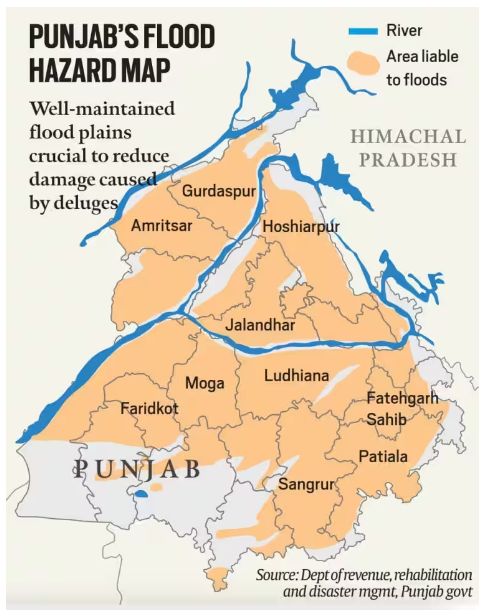
- Flood plain areas of Sutlej, Beas, Ravi and Ghaggar have been encroached upon, making villages along these rivers perennially at risk of floods whenever they swell.
About Floodplains:
- A floodplain (or floodplain) is a generally flat area of land next to a river or stream.
- It stretches from the banks of the river to the outer edges of the valley.
- Major Processes involved in the natural development of floodplains:
- The erosion of a floodplain describes the process in which earth is worn away by the movement of a floodway.
- Aggradation (or alluviation) of a floodplain describes the process in which earthen material increases as the floodway deposits sediment.
- Geomorphologically, the floodplains in India are of two types:
- Peninsular (found in the Deccan plateau) where there are rock terraces (step-like structures created by lava flows), and
- those found in the Himalayan region, which are old, wide and depositional (created by the deposition of sediment).
Characteristics of Floodplains:
- Seasonal Flooding & Fertility: A flood plain regularly overflows, which deposits a layer of fine soil, rich mineral salts, nutrient-rich silt, which make the soil fertile.
- Water Storage and Flow Regulation: Floodplains can absorb excess water during periods of high flow, helping to reduce the risk of downstream flooding.
- Dynamic in nature: Floodplains are not static; they continue to evolve as rivers erode, deposit sediment, and change their course over time.
- Topographical Features: Floodplains often contain oxbow lakes – basically abandoned meandering channels of the river, where it once flowed prior to changing its course.
- Densely Populated: Flood plains are generally densely populated because rivers are a perennial source of water, thus people tend to live in areas where water is available.
Zoning of Flood Plains:
- Zoning of floodplains refers to the practice of designating different areas within a floodplain for specific land uses and activities based on their vulnerability to flooding and associated risks.
- Floodplain zoning guidelines:
- The Central Water Commission prepared floodplain zoning guidelines and the Model Bill for Floodplain Zoning was circulated by the Government of India in 1975.
- Four states followed this up by passing floodplain zoning acts: Manipur in 1978, Rajasthan in 1990, erstwhile state Jammu and Kashmir in 2005 and Uttarakhand in 2012.
- Acts provide for the establishment of a “Flood Zoning Authority”, to conduct surveys to determine the nature or extent of floodplains, prohibit or restrict the use of land in the floodplains, and impose penalties for non-compliance.
Significance of Zoning of FloodPlains
- To manage and regulate development in flood-prone areas, aiming to minimize damage to property, protect human life, and maintain the ecological functions of the floodplain.
- Flood Risk Reduction: Zoning helps to manage and reduce the risk of flood-related damage to property, infrastructure, and human lives.
- By restricting or guiding development in areas prone to flooding, communities can avoid or minimize the negative impacts of floods.
- Public Safety: Zoning ensures that areas most vulnerable to flooding, such as floodways, remain free of development.
- This prevents people and property from being exposed to fast-moving floodwaters, reducing the potential for casualties and injuries.
News Source: The Indian Express


 29 Aug 2023


 GS Foundation
 Crash Course
 Combo
Combo Optional Courses
 Degree Program