Upto 60% Off on UPSC Online Courses

Avail Now

NCERT NOTES

Elevate your UPSC preparation with NCERT Notes – because every word matters on your journey to success.

Indian Geography: Location and Overview

June 20, 2024 2864 0

Indian Geography: From the Himalayas to the Ocean Shores

India is a country of vast geographical expanse. It covers an area of 3.28 million square kilometres, accounting for 2.4 per cent of the world’s total area. In the north, it is bound by the lofty Himalayas, in the west lies the Arabian Sea, in the east lies the Bay of Bengal and in the south lies the Indian Ocean, washing the shores of the Indian peninsula.

POINTS TO PONDER

Historically, India’s location has helped her to maintain a central position in world trade throughout most of her history. On the other hand, It has hindered the growth of Indian Political Entities and restricted them within the confines of the Himalayas and the Indian Ocean. Do you think India’s location in the world map is a double edged sword. If yes, find out the positives and negatives emanating due to the location of India.

India’s Global Geopolitical Position: Embracing Indian Geography

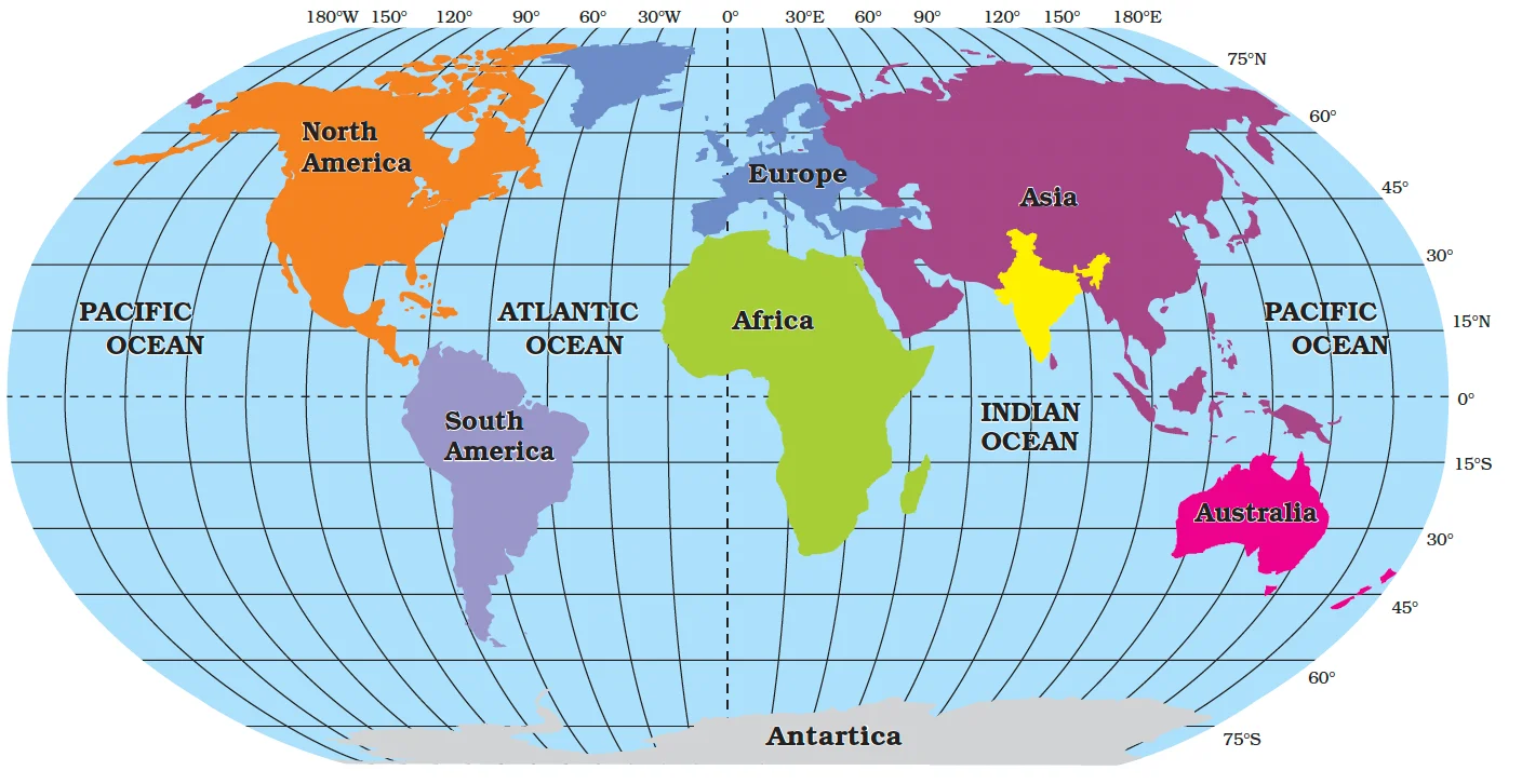
  • Location: Bridging East and West: The Indian landmass has a central location between East and West Asia (Refer Figure ). 
    • The trans-Indian Ocean routes, which connect the countries of Europe in the West and the countries of East Asia, provide a strategic central location to India. 
    • The Deccan Peninsula protrudes into the Indian Ocean, thus helping India to establish close contact with West Asia, Africa and Europe from the western coast and with Southeast and East Asia from the eastern coast. 

Enroll now for UPSC Online Course

Additional Information

Since the opening of the Suez Canal in 1869, India’s distance from Europe, has been reduced by 7,000 km. The Suez Canal is Artificial sea level waterway connecting Indian Ocean to Pacific Ocean.

  • Longest Coastline in the Indian Ocean: India has the longest coastline among the Indian Ocean Littoral countries and has had an eminent position in the Indian Ocean, which justifies the naming of an Ocean after it.

India and the World

India and the World

How does Indian Geography influence relations with Neighbouring Countries?

  • Location and Maritime Significance: India is located in the south-central part of the continent of Asia, bordering the Indian Ocean and its two arms extending in the form of the Bay of Bengal and the Arabian Sea. 
    • The maritime location of Peninsular India has provided links to its neighbouring regions through the sea and air routes.
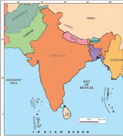
  • There are seven countries (Refer to Figure) that share land boundaries.
    • Northwest Boundaries: With Pakistan and Afghanistan,
    • North Boundaries: With China, Nepal, and Bhutan and 
    • East Boundaries: With Myanmar and Bangladesh.
  • Landlocked Countries: Among India’s neighbours Afghanistan, Nepal and Bhutan do not have access to any ocean or sea.
  • In the Indian Ocean lie our island neighbours -Sri Lanka and Maldives.
    • Sri Lanka is separated from India by the Gulf of Mannar and Palk Strait.
    • Maldives Islands are situated to the south of the Lakshadweep Islands.
  • India has had strong geographical and historical links with its neighbors.

India and its neighbours

India and its neighbours

What defines the Extent of Indian Geography and Oceanic Presence?

  • India is located in the northern hemisphere. 
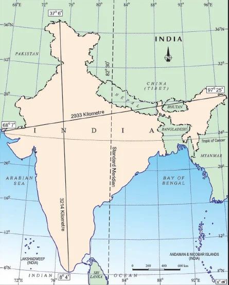
  • Latitudinal Extent: The mainland of India extends between 8°4’N and 37°6’N latitudes from Ladakh to Kanyakumari is about 3,200 km.
  • Longitudinal Extent:  From east to west, India extends between 68°7’E and 97°25’E longitudes from Arunachal Pradesh to Kutch is about 2,900 km (Refer Figure).

Extent and Standard Meridian

India: Extent and Standard Meridian

    • Location of Indian Islands: To the Southeast mainland lie the Andaman and Nicobar Islands in the Bay of Bengal.
      • To the Southwest of the mainland lie the Lakshadweep Islands.
  • Expansive Land Boundary and Coastline Length: 
    • India has a land boundary of about 15,200 km.
    • The total length of India’s coastline (Including Andaman and Nicobar and Lakshadweep islands) is 7,516.6 km.
    • No other country has a long coastline on the Indian Ocean as India has and indeed, it is India’s eminent position in the Indian Ocean

Do You Know ?

82°30’E has been selected as the Standard Meridian of India as it passes through the centre of India.

India’s Coastal Limit: It extends towards the sea up to 12 nautical miles (about 21.9 km) from the coast.    

How does Indian Geography shape the Physical and Administrative Division of India?

Physical Divison

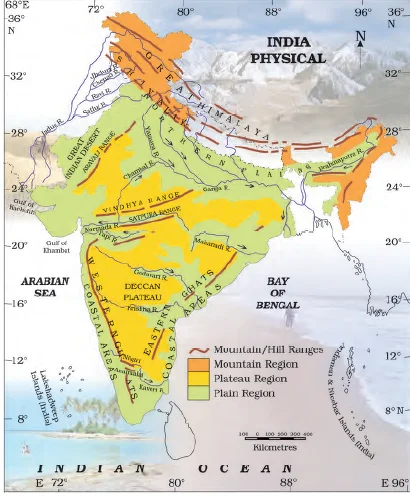
  •  Physical Features: A Panoramic View of Indian Geography: India is marked by a diversity of physical features such as mountains, plateaus, plains, coasts and islands (Refer Figure).
    • Physical Map of IndiaStanding as sentinels in the north are the lofty snow-capped Himalayas. 
    • Him+alaya mean ‘the abode of snow’. 
  • Himalayan Majesty: Ranges and Valleys in Indian Geography: These are divided into three main parallel ranges. These are:
    • Great Himalayas: Also known as Himadri. It is the northernmost range.
      • The world’s highest peaks are located in this range. 
    • The Middle Himalaya: Also known as Himachal lies to the south of Himadri. 
      • Many popular hill stations are situated here. 
    • The Shiwalik is the southernmost range.
    • Duns: The longitudinal valley lying between lesser Himalaya and the Shiwaliks are known as Duns.
      • DehraDun, Kotli Dun and Patli Dun are some of the well-known Duns.

Enroll now for UPSC Online Classes

Do you know?

The Ganga and the Brahmaputra form the world’s largest delta, the Sundarbans delta. The delta is triangular in shape. It is an area of land formed at the mouth of the river (Where rivers enter the sea, that point is called the mouth of the sea).

  • Northern Plains to Western Deserts: Diversity in the Indian Landscape: It lies to the south of the Himalayas. 
    • They are generally flat and formed by the alluvial deposits laid down by the rivers– the Indus, the Ganga, the Brahmaputra and their tributaries. 
  • Great Indian desert: It lies In the western part of India. 
    • It is a dry, hot and sandy stretch of land.
    • It has very little vegetation.

Do You Know ?

The southernmost point of the Indian Union– ‘Indira Point’ got submerged under the sea water in 2004 during the Tsunami.

  • Peninsular Plateau: Triangular Terrain and River Networks: It lies to the south of the northern plains. 
    • It is triangular in shape and the relief is highly uneven. 
      • This is a region with numerous hill ranges and valleys. 
    • Aravali hills, one of the oldest ranges of the world, border it on the northwest side. 
      • The  Vindhyas and the Satpuras are the important ranges.
      • The rivers Narmada and Tapi flow through these ranges. 
        • These are west-flowing rivers that drain into the Arabian Sea.
    •  The Western Ghats or Sahyadris border the plateau in the west and the Eastern Ghats provide the eastern boundary. 
            • While the Western Ghats are almost continuous, the Eastern Ghats are broken and uneven. 
Do You Know ?

  • The Tropic of Cancer (23°30’N)  divides the country into two almost equal halves.
  • The Southern half i.e. southern part of the country lies within the tropics
  • The northern part lies in the subtropical zone or the warm temperate zone. 


  • Coastal Plains and Islands: Indian Geography: To the West of the Western Ghats and the East of the Eastern Ghats lie the Coastal plains. 
    • The western coastal plains are very narrow whereas eastern coastal plains are much broader. 
    • There are a number of east-flowing rivers. 
      • The rivers Mahanadi, Godavari, Krishna and Kaveri drain into the Bay of Bengal. 
      • These rivers have formed fertile deltas at their mouths. 
    • The Sunderban Delta: It is formed where the Ganga and Brahmaputra flow into the Bay of Bengal.
  • Islands: Lakshadweep, Andaman, and Nicobar Islands: Two groups of islands also form part of India. 
    • Lakshadweep Islands are located in the Arabian Sea
      • These are coral islands located off the coast of Kerala.
  • The Andaman and the Nicobar Islands lie to the southeast of the Indian mainland in the Bay of Bengal.

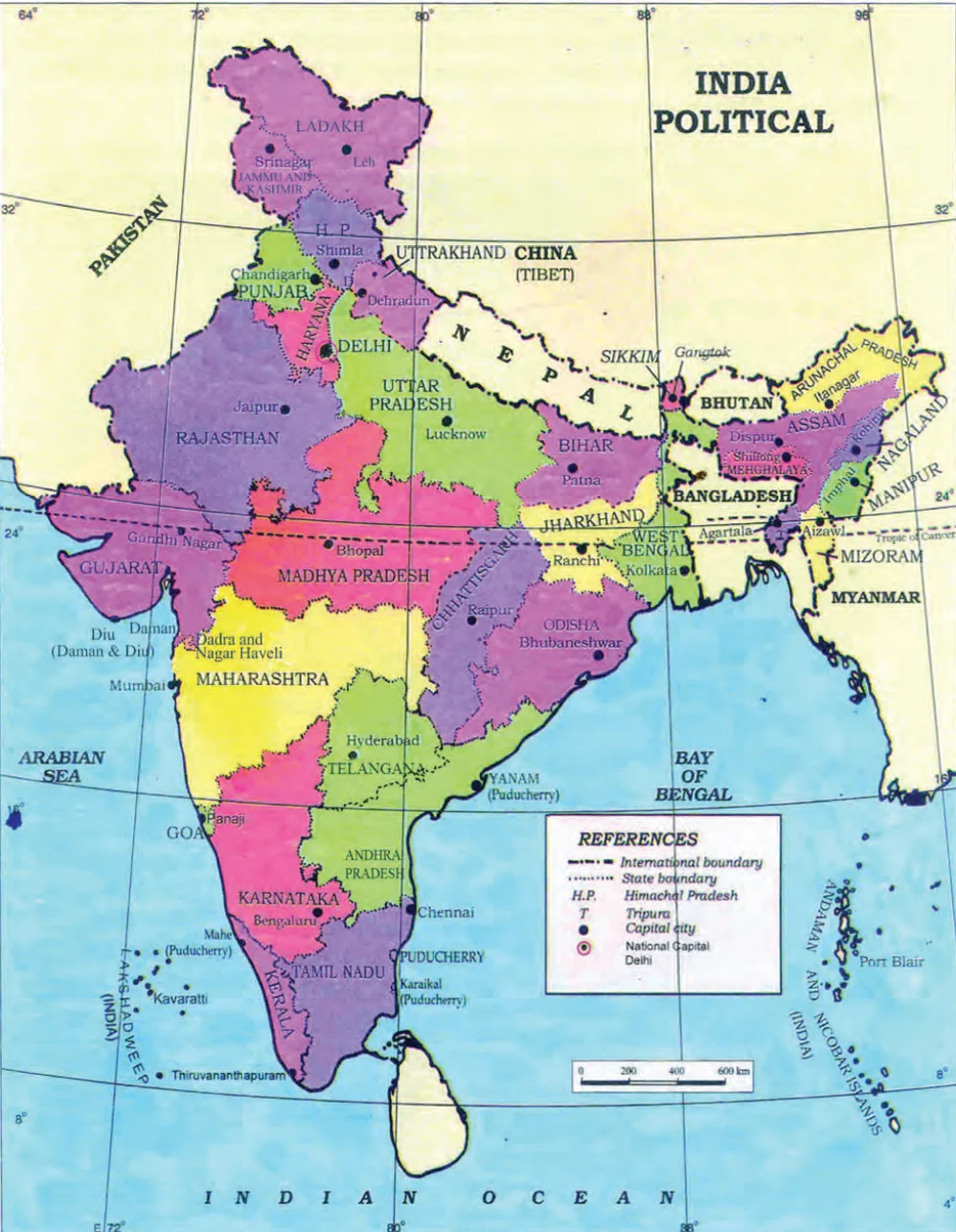
India Political Map

India Political Map

Do You Know ?

Corals are skeletons of tiny marine animals called Polyps. When the living polyps die, their skeletons are left. Other polyps grow on top of the hard skeleton which grows higher and higher, thus forming the coral islands.

       Administrative division: States, Union Territories, and the National Capital

  • India is a vast country. For administrative purposes, the country is divided into 28 States and 8 Union Territories (Refer Figure)
  • Delhi is the national capital.

Enroll now for UPSC Online Course

Conclusion

  • The geographical location of a country has a bearing on its climate, economic activities, culture as well and defence.
  • In order to have a better understanding of one’s own country it is worthwhile to study the location and the advantages and disadvantages resulting from it. 
  • Further, major policies of India namely Economic policies, Energy policies, Foreign trade policies, Defence policies, and Foreign policies take into account the location of India.
Glossary

  • Latitude: Often called parallels or circles of latitude, latitudes are imaginary circles parallel to the equator.
  • Longitude: Latitudes specify the north-south position of a location on the globe.
  • Tropic of Cancer: The Tropic of Cancer lies at 23°30′ north of the Equator and marks the most northerly latitude at which the sun can appear directly overhead at noon.
  • Indian Ocean Littoral countries: Countries having coastline in the Indian Ocean.
  • Standard Meridian: It is a longitude that determines standard time for the country. Standard Meridian of India is 82 degrees 30 minutes and passes through Mirzapur(Uttar Pradesh)
  • Island: It is a body of land that is surrounded by water.
  • Coastal Plain: It is a flat, low-lying piece of land next to the ocean.
  • Plateau: It is a flat, elevated landform that rises sharply above the surrounding area on at least one side.
  • Alluvial Deposits: These are very fine soils, brought by rivers and deposited in the river basins. 
  • Tributary: A river or stream which contributes its water to a main river by discharging it into the main river from either side.
  • Peninsula: It is a piece of land that is surrounded by water on three sides.


Must Read
Current Affairs Editorial Analysis
Upsc Notes  Upsc Blogs 
NCERT Notes  Free Main Answer Writing
Print Friendly, PDF & Email

Need help preparing for UPSC or State PSCs?

Connect with our experts to get free counselling & start preparing

 Final Result – CIVIL SERVICES EXAMINATION, 2023.   Udaan-Prelims Wallah ( Static ) booklets 2024 released both in english and hindi : Download from Here!     Download UPSC Mains 2023 Question Papers PDF  Free Initiative links -1) Download Prahaar 3.0 for Mains Current Affairs PDF both in English and Hindi 2) Daily Main Answer Writing  , 3) Daily Current Affairs , Editorial Analysis and quiz ,  4) PDF Downloads  UPSC Prelims 2023 Trend Analysis cut-off and answer key

THE MOST
LEARNING PLATFORM

Learn From India's Best Faculty


 Final Result – CIVIL SERVICES EXAMINATION, 2023.   Udaan-Prelims Wallah ( Static ) booklets 2024 released both in english and hindi : Download from Here!     Download UPSC Mains 2023 Question Papers PDF  Free Initiative links -1) Download Prahaar 3.0 for Mains Current Affairs PDF both in English and Hindi 2) Daily Main Answer Writing  , 3) Daily Current Affairs , Editorial Analysis and quiz ,  4) PDF Downloads  UPSC Prelims 2023 Trend Analysis cut-off and answer key

Quick Revise Now !
AVAILABLE FOR DOWNLOAD SOON
UDAAN PRELIMS WALLAH
Comprehensive coverage with a concise format
Integration of PYQ within the booklet
Designed as per recent trends of Prelims questions
हिंदी में भी उपलब्ध
Quick Revise Now !
UDAAN PRELIMS WALLAH
Comprehensive coverage with a concise format
Integration of PYQ within the booklet
Designed as per recent trends of Prelims questions
हिंदी में भी उपलब्ध

<div class="new-fform">


    </div>

    Subscribe our Newsletter
    Sign up now for our exclusive newsletter and be the first to know about our latest Initiatives, Quality Content, and much more.
    *Promise! We won't spam you.
    Yes! I want to Subscribe.