Explore Our Affordable Courses

Click Here

Natural Hazards and Disasters: Causes, Impacts and Mitigation Measures

June 24, 2024 465 0

Disasters, like earthquakes and tsunamis, disrupt communities, causing extensive damage beyond their ability to cope. They result from hazards, vulnerabilities, and limited capacity to manage risks. Understanding these terms is crucial to prepare for and respond to such events.
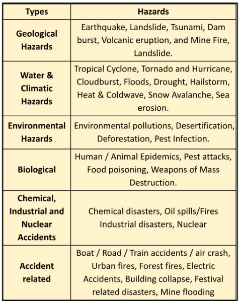
Natural Hazards and Disasters: Disaster, Hazard, Vulnerability, and Risk

Natural Hazards and Disasters

  • Disaster: It can be defined as “A serious disruption in the functioning of the community or a society causing widespread material, economic, social or environmental losses which exceed the ability of the affected society to cope using its own resources”. 
    1. It is a result of the combination of hazard, vulnerability and insufficient capacity to reduce the potential chances of risk.
  • Hazard: It may be defined as a dangerous condition or event that threatens or has the potential for causing injury to life or damage to property or the environment’’.
  • Vulnerability: It may be defined as the extent to which a community, structure, services or geographic area is likely to be damaged or disrupted by the impact of a particular hazard, on account of their nature, construction and proximity to hazardous terrains or disaster-prone area”. Vulnerabilities can be categorized into:
  • Physical Vulnerability: It includes notions of who and what may be damaged or destroyed by natural hazards. 
    1. It is based on the physical condition of people and elements at risk, such as buildings, infrastructure etc.
  • Socio-economic Vulnerability refers to the degree to which individuals and communities are susceptible to harm from disasters due to their social and economic status.
  • Risk is a measure of the expected losses due to a hazard event occurring in a given area over a specific time period.  

Enroll now for UPSC Online Course

Understanding Earthquakes and Tsunamis: Causes, Measurement, and Impact

A. Earthquakes

  • Definition: Earthquake refers to the sudden shaking of the earth’s crust.
  • Causes of Earthquakes
    1. Earthquakes due to Plate Tectonics
    2. Earthquakes due to other causes: volcanic eruption, rock falls, landslides, subsidence, particularly in the mining areas, impounding of dams and reservoirs, etc. 
  • Measuring Earthquakes: Earthquakes can be measured by the use of two distinctively different scales of measurement: 
    1. Richter Scale: Measures the magnitude (strength/elastic energy released by earthquake) of the earthquake. 
      • It is a logarithmic scale—an increase of 1 in magnitude corresponds to a 10-fold increase in the amplitude of shaking. 
      • It is expressed numerically, ranging from 0 to 10.
    2. Mercalli Scale: Measures the intensity (effects) of an earthquake where it occurs; scale spans from 1 to 12
      • Natural Hazards and Disasters Intensity indicates the violence of shaking or the extent (or potential) of damage at a given location due to a particular earthquake. 
      • The most commonly used intensity scales are: Modified Mercalli (MM) Intensity Scale and Medvedev-Sponhener-Karnik (MSK) Intensity Scale.
    3. Modified Mercalli Scale: Enhanced and more detailed version of the original Mercalli Intensity Scale, providing a better description of the effects of an earthquake at a specific location.
  • The five seismic zones I, II, III, IV and V in the Indian seismic code (IS:1893-1984) correspond to areas that have potential for shaking intensity on the MMI scale of V or less, VI, VII, VIII, and IX or more, respectively.

Distribution Pattern of Earthquakes in India

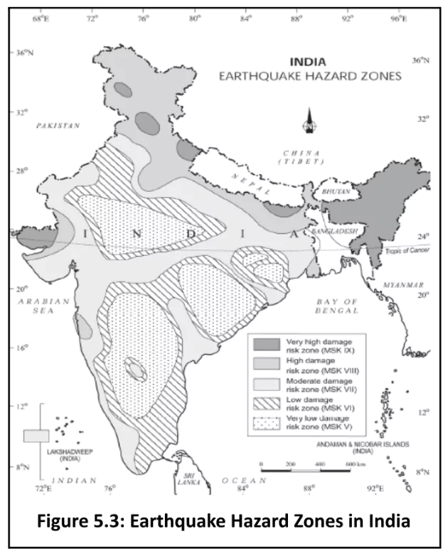
  • Seismic Zoning Map of India: It is divided into the following five earthquake zones: 
    1. Very high damage risk zone;  
    2. High damage risk zone; 
    3. Moderate damage risk zone; 
    4. Low damage risk zone; 
    5. Very low damage risk zone.
  • Very High Damage Risk Zone: North-east states, areas to the north of Darbhanga and Araria along the Indo-Nepal border in Bihar, Uttarakhand, Western Himachal Pradesh (around Dharamshala) and Kashmir Valley in the Himalayan region and the Kachchh (Gujarat).
  • High Damage Risk Zone: Parts of Jammu and Kashmir, Ladakh, Himachal Pradesh, Northern parts of Punjab, Eastern parts of Haryana, Delhi, Western Uttar Pradesh, and Northern Bihar.
  • Remaining Parts of the Country: fall under moderate to very Low Damage Risk Zone
  • Deccan Plateau: Most of the areas of the Deccan plateau are considered safe as far as earthquakes are concerned.

Tsunami

  • Definition: Tsunami refers to a series of large waves on ocean surfaces caused by a sudden displacement of water. These are also called shallow water waves.
  • Causes of a Tsunami:
    • The geological movements that cause tsunamis are produced in three major ways:
    • Fault Movements: on the seafloor, accompanied by an earthquake that causes tsunamis.
    • Landslides: either occurring underwater or originating above the sea.
      • Volcanic Activity: near the shore or underwater. 
    • Example: Krakatoa eruption (1883) in Indonesia, produced a tsunami in Java and Sumatra.
  • General Characteristics of Tsunami:
    • Speed of Waves: in the ocean depends upon the depth of the water. 
      • It is more in the shallow water than in deep oceans because, as a tsunami enters shallow water near land, it slows down, wavelengths decrease, waves grow in height, and currents intensify.
    • Impact: It is less over the ocean and more near the coast.
    • Examples: Tsunamis are frequently observed along the Pacific Ring of Fire, particularly along the coast of Alaska, Japan, the Philippines and other islands of Southeast Asia, Indonesia, Malaysia, Myanmar, Sri Lanka, and India.

Enroll now for UPSC Online Classes

  • India has volunteered to join the International Tsunami Warning System after the 2004 tsunami disaster.


Must Read
Current Affairs Editorial Analysis
Upsc Notes  Upsc Blogs 
NCERT Notes  Free Main Answer Writing

Conclusion

Earthquakes, sudden shifts in the earth’s crust, and tsunamis, large ocean waves, pose significant threats. India, particularly prone to earthquakes and tsunamis, has measures in place, like seismic zoning and joining the International Tsunami Warning System, to mitigate risks and enhance preparedness.

Related Articles 
Interior of the Earth: Crust, Mantle and Core ENVIRONMENT
Volcanoes: Origins, Characteristics, and Distribution Disaster Management in India – Types, Impact and Challenges


Download October 2024 Current Affairs.   Srijan 2025 Program (Prelims+Mains) !     Current Affairs Plus By Sumit Sir   UPSC Prelims2025 Test Series.    IDMP – Self Study Program 2025.


THE MOST
LEARNING PLATFORM

Learn From India's Best Faculty


Download October 2024 Current Affairs.   Srijan 2025 Program (Prelims+Mains) !     Current Affairs Plus By Sumit Sir   UPSC Prelims2025 Test Series.    IDMP – Self Study Program 2025.


Quick Revise Now !
AVAILABLE FOR DOWNLOAD SOON
UDAAN PRELIMS WALLAH
Comprehensive coverage with a concise format
Integration of PYQ within the booklet
Designed as per recent trends of Prelims questions
हिंदी में भी उपलब्ध
Quick Revise Now !
UDAAN PRELIMS WALLAH
Comprehensive coverage with a concise format
Integration of PYQ within the booklet
Designed as per recent trends of Prelims questions
हिंदी में भी उपलब्ध

<div class="new-fform">


    </div>

    Subscribe our Newsletter
    Sign up now for our exclusive newsletter and be the first to know about our latest Initiatives, Quality Content, and much more.
    *Promise! We won't spam you.
    Yes! I want to Subscribe.