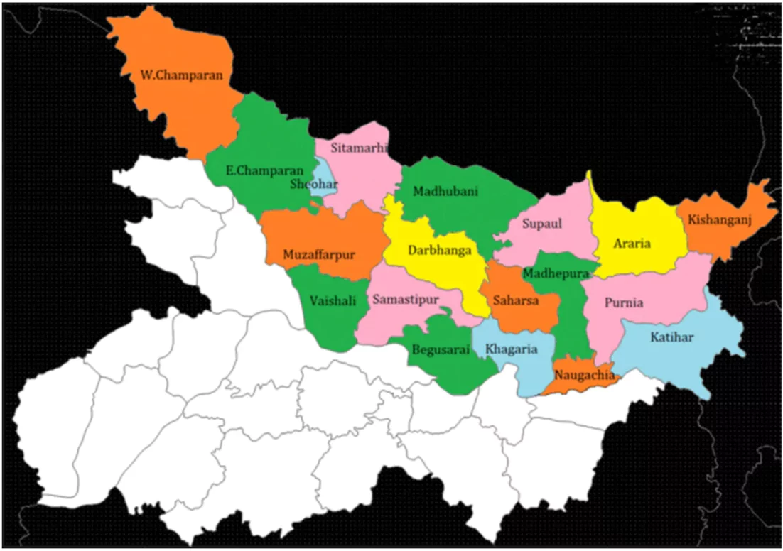
Bihar is again flooded like every year in North Bihar.
More on the news
- It has affected 11.84 lakh people overall who are forced to leave their homes.
- Affected Areas
-
- Flooded Districts: Over 9.9 lakh people from 16 districts in northern Bihar have been severely impacted, including West Champaran, Sitamarhi, Sheohar, Darbhanga, and others.
- Specific Incidents: Floodwaters have entered villages in Darbhanga after the Kosi river breached its embankment.

Status of Flood in Bihar
- Bihar is the most flood-prone state in India.
- Approximately 76% of North Bihar’s population lives under the constant threat of severe floods.
- The state accounts for 16.5% of India’s total flood-affected area and 22.1% of its flood-affected population.
Enroll now for UPSC Online Classes
Causes of Flooding in Bihar
- Geographical Factors
- Location: Bihar is located downstream from Nepal, where major rivers like the Kosi and Gandak flow.
- These rivers carry a lot of sediment because of the young Himalayan mountains.
- Siltation: Sediment builds up in the riverbeds, causing them to rise. When heavy rain occurs, this can lead to rivers overflowing.
- River Networks: Bihar has many rivers that are fed by snow and rain, making it more vulnerable to different types of flooding.
- North Bihar is at risk of flood from five primary rivers during the monsoon season:
- Mahananda
- Koshi
- Bagmati
- Burhi Gandak
- Gandak
- Low-Lying Terrain: Bihar’s flat land makes it especially prone to waterlogging, particularly during heavy rains.
- Permanent Waterlogging
- Silted Rivers: The accumulation of silt in rivers makes it harder for water to drain away, contributing to waterlogging.
- Encroachment on Drainage Channels: Building on or blocking drainage channels restricts the natural flow of water, worsening flooding.
- Changes in River Courses: When rivers change their paths, they can create saucer-shaped depressions called Chaurs, which can hold water and lead to permanent waterlogging.
Categorisation of Floods

- The Bihar Disaster Management Authority classifies floods into four categories:
- Flash Floods: Quick onset (8-hour lead time), fast receding.
- River Floods: 24-hour lead time, recedes over a week.
- Drainage Congestion: Lasts the entire monsoon season, takes 3 months to recede.
- Permanent Waterlogging: Long-term inundation due to silted rivers and drainage issues.
Impact of Floods
- Loss of Life and Property: Floods can result in loss of lives, displacement of people, and damage to infrastructure.
- Economic Impact: Floods can cause significant damage to crops, livestock, and livelihoods.
- Distress Migration: People may be forced to migrate to other regions due to the loss of their homes and livelihoods.
Check Out UPSC NCERT Textbooks From PW Store
Recommendations
- Integrated Flood Management: Implementing comprehensive flood management strategies that address both structural and non-structural aspects.
- Structure solutions include systems such as embankments, dams, etc.
- Non structural solutions comprises policy, laws, risk mitigation strategies, etc.
- Infrastructure Improvement: Strengthening embankments and other infrastructure to enhance resilience against floods.
- Early Warning Systems: Developing and improving early warning systems to provide timely alerts.
- Community-Based Disaster Management: Empowering local communities to participate in flood preparedness and response.
- Regional Cooperation: Strengthening cooperation with Nepal to manage shared river systems and reduce flood risks.
- Sustainable Land Use Planning: Implementing land use policies that minimize flood risks and promote sustainable development.
- Long-Term Solutions: Exploring long-term solutions such as constructing dams or reservoirs to regulate river flows.
![]() 3 Oct 2024
3 Oct 2024


