The Prime Minister will virtually distribute 58 lakh property cards, providing “record of rights” to property owners under SVAMITVA Scheme.
Implementation Status of Svamitva Scheme
- Drone Mapping: 92% of drone mapping has been completed, covering approximately 3.17 lakh villages out of the targeted 3.44 lakh villages.
- The SVAMITVA scheme’s targets are expected to be fully achieved by 2026.
- Participation by States and UTs: A total of 31 states and Union Territories have joined the initiative.
- Sikkim, Telangana, and Tamil Nadu participated only during the pilot phase of the scheme.
- Property Card beneficiaries include owners from over 50,000 villages across 12 States.
|
Enroll now for UPSC Online Course
About SVAMITVA Scheme
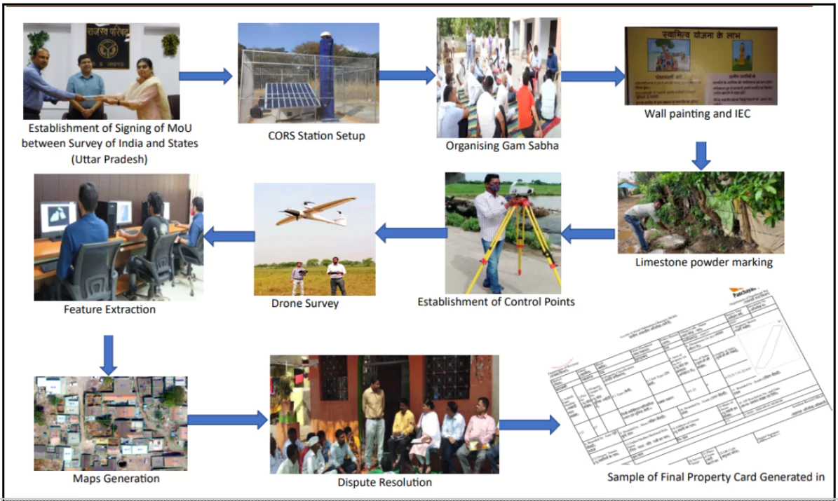
- SVAMITVA Scheme (Survey of Villages and Mapping with Improvised Technology in Village Areas) is a Central Sector Scheme launched on National Panchayati Raj Day, 24th April 2020.
- Aims: To provide the ‘Record of Rights’ to village household owners possessing houses in inhabited areas (Abadi) in villages with issuance of legal ownership rights (Property cards/Title deeds)
- Under the scheme, the land parcels in rural inhabited areas of all the villages of the country are surveyed.
CORS Network
- CORS (Continuously Operating Reference Station) network provides a regional positioning service for highly accurate geospatial applications.
- Infrastructure Functionality: Corrections to maps are instantly transmitted from the control center to the rover receiver.
- Ensures real-time accurate positioning of the rover.
- Role in Achieving High Accuracy: Enables centimetre-level accuracy for various applications.
- Applications:
- Cadastral Mapping: Ensures precision in property boundary demarcation.
- Land Information Management: Supports efficient land administration.
- Large-Scale Mapping: Useful for infrastructure projects and urban planning.
|
- Implementing Agency: It is being implemented with the collaborative efforts of the Ministry of Panchayati Raj, Survey of India (SoI), State Revenue Department, State Panchayati Raj Department and National Informatics Centre.
- States need to sign Memorandum of Understanding (MoU) with SoI for implementation of the scheme.
- SoI is a technology partner for implementation
- It also included the establishment of the CORS network across states.
About Property Cards
- Property cards under the SVAMITVA scheme are legal documents that provide clear ownership records for rural properties. These cards are known by various names in different states, including:
- Haryana: Title deed
- Karnataka: Rural Property Ownership Records (RPOR)
- Madhya Pradesh: Adhikar Abhilekh
- Maharashtra: Sannad
- Uttarakhand: Svamitva Abhilekh
- Uttar Pradesh: Gharauni

Utility of Property Cards
- Facilitating Financial Stability: Recognised by banks for loans, enabling property owners to use their land as a financial asset.
- Provides access to financial benefits and ensures greater economic security for rural citizens.
- Strengthening Women’s Ownership: Enhances property ownership for women, promoting gender equality in asset ownership.
- Reducing Disputes and Tax Clarity: Minimises property-related disputes and legal cases by providing clear ownership records.
- Facilitates the determination and collection of property tax.
Check Out UPSC CSE Books From PW Store
Overall Benefits of SVAMITVA Scheme
- Improved Rural Planning: Aids in creating accurate land records for effective rural planning.It also identifies open spaces for better community development initiatives.
- Enabling Quality Development Plans: Supports Gram Panchayats in preparing Gram Panchayat Development Plans (GPDP) using GIS-based maps.
- Ensures participatory planning aligned with economic development and social justice goals, in convergence with the 29 subjects listed in the Eleventh Schedule of the Constitution.
- Multi-Departmental Utility: Survey infrastructure and GIS maps can be leveraged by multiple departments for various applications.
![]() 26 Dec 2024
26 Dec 2024

