December 26, 2024, marks the 20th year since the 2004 Indian Ocean earthquake and tsunami.
About Indian Ocean Tsunami of 2004
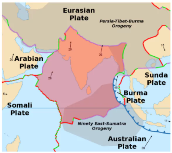
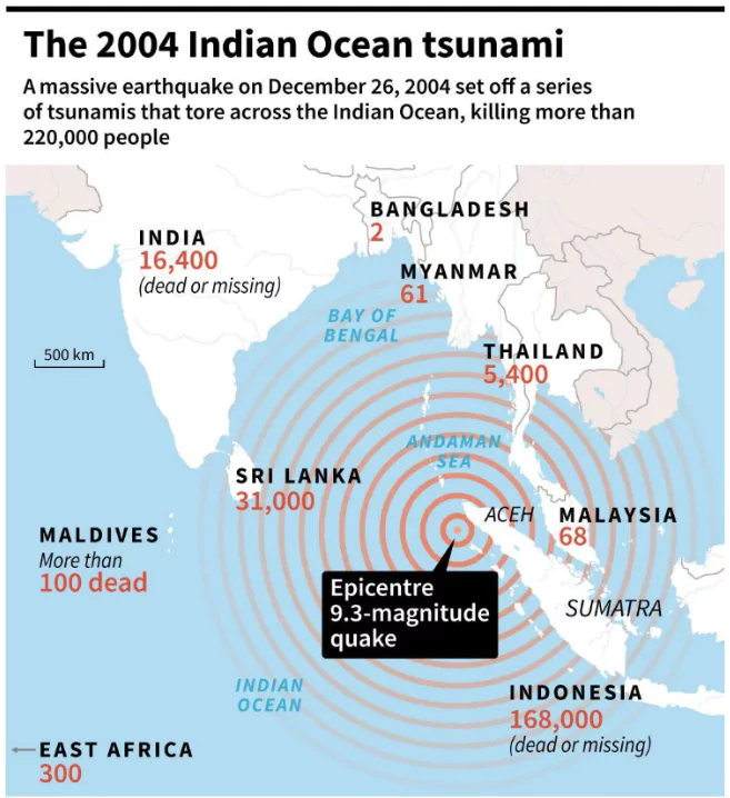
- The 2004 tsunami occurred on December 26, triggered by a magnitude 9.1 earthquake in the Sunda Trench.
- The disaster affected 14 countries, including Indonesia, Sri Lanka, India, and Thailand.
- Over 2,27,000 people lost their lives, making it one of the deadliest natural disasters in history.
- Source of Indian Ocean Tsunami
- It is the third largest since 1900, originating 30 km below the ocean floor in the Sunda trench.
- It ruptured 1,300 km of the plate boundary, extending from Sumatra to the Coco Islands.
- The Indo-Australian plate subducted beneath the Burma microplate, part of the Eurasian plate, triggering the tsunami.
Enroll now for UPSC Online Course
About Sunda Trench
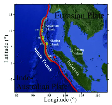
- The Sunda Trench is the deepest ocean trench of the Indian Ocean.
- Location: Located in the eastern Indian Ocean, south and west of the islands of Java and Sumatra.
- It stretches from the Andaman Islands, past Java, around the southern coast of Sumatra, and to the Lesser Sunda Islands.
- Length: 3,200 kilometers (2,000 miles) long.
- Depth: Maximum depth is 7,290 meters (23,920 feet).
- Formation: Formed when the Australian-Capricorn plates subducted beneath the Eurasian plate.
- Seismic activity: The Sunda Trench is part of the Pacific Ring of Fire and is seismically active.
|
About Tsunami
- Definition: A series of large ocean waves caused by underwater disturbances such as earthquakes, landslides, or volcanic eruptions.
- Etymology: Derived from the Japanese words “tsu” (harbor) and “nami” (wave).
- Causes of Tsunami
- Submarine Earthquakes: Most common cause (e.g., 2004 Indian Ocean tsunami caused by a 9.1 magnitude earthquake).
- Volcanic Eruptions: Sudden displacement of water due to eruptions (e.g., 1883 Krakatoa eruption).
- Landslides: Coastal or submarine landslides can generate tsunamis. (e.g., 2017 Karrat Fjord landslide, Greenland)
- Asteroid Impacts: Rare but catastrophic; can generate massive waves.
- Characteristics:
- Formation and Triggering: The primary mechanism involves the sudden displacement of a large volume of water.
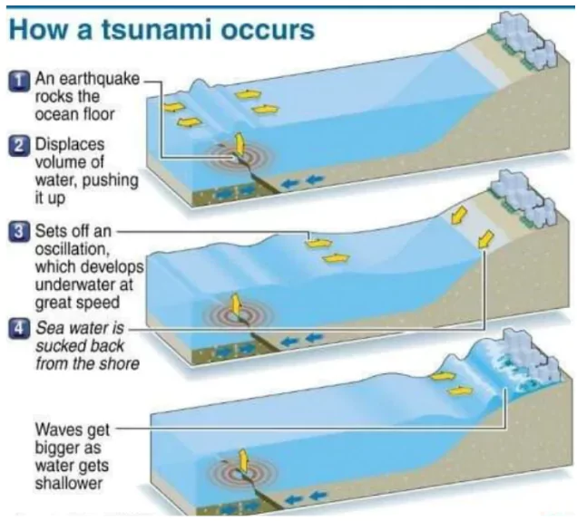 Speed and Propagation: In deep oceans, tsunamis can travel at speeds up to 800 km/h, comparable to the speed of a jet aircraft.
- The speed depends on the depth of the water, decreasing as the tsunami approaches shallow coastal waters.
- Wave Properties:
- Wavelength: Tsunamis have extremely long wavelengths, often exceeding 500 km.
- Wave Period: The time between successive waves can range from 10 minutes to 2 hours.
- Wave Amplitude (Height): In deep water, wave heights are typically small (30–60 cm), making them undetectable by ships.
- Shoaling Effect: As tsunamis enter shallow waters, their speed decreases, and wave heights increase dramatically due to energy conservation.
- This transformation can cause wave heights to reach 10–30 meters or more near the coastline.
- Multiple Waves: Not a single wave but a series of waves known as a wave train.
- The first wave is often not the largest, with subsequent waves potentially causing more destruction.
- Energy Conservation: Lose minimal energy as they propagate across oceans due to their long wavelengths, making them capable of causing damage over vast distances.
- Tsunami Hotspots: Tsunamis are frequently observed along the Pacific Ring of Fire, particularly along the coast of Alaska, Japan, the Philippines and other islands of Southeast Asia, Indonesia, Malaysia, Myanmar, Sri Lanka, and India.
Environmental and Economic Impact of Tsunamis
- Environmental Impact
- Destruction of Ecosystems: Loss of natural barriers like Mangroves, Coral Reefs, and Forests, increases vulnerability to future coastal hazards.
- The 2004 Indian Ocean tsunami caused extensive damage to coral reefs and mangroves in Indonesia, with 90% of mangroves in some regions destroyed.
- Soil and Water Contamination: Pollution from hazardous materials mixed with debris further degraded the environment.
- Saltwater Intrusion: The 2004 tsunami rendered 62,000 wells in Sri Lanka unusable due to saltwater contamination. Agricultural lands became infertile due to salination and debris.
- Marine Pollution: The tsunami dragged tons of waste, including plastics and hazardous materials, into the ocean. In Banda Aceh, Indonesia, tsunami debris significantly affected marine ecosystems.
- Loss of Biodiversity: The 2004 tsunami caused extensive habitat destruction, leading to a decline in populations of coastal and marine species.
- Geographical Shifts: The 2004 tsunami shifted the North Pole by 2.5 cm and reduced the length of the day by 2.68 microseconds.
- The Andaman and Nicobar Islands were reported to have shifted by 1.25 meters.
- Economic Impact
- Loss of Livelihoods: In Tamil Nadu, India, over 30,000 fishing boats were destroyed during the 2004 tsunami, crippling the fishing industry.
- Salination of agricultural lands in Indonesia and Sri Lanka led to reduced crop yields.
- Infrastructure Damage: The tsunami caused massive destruction of infrastructure, including ports, roads, and buildings.
- Overall economic losses from the 2004 Indian Ocean Earthquake and Tsunami disaster are estimated at $10 billion, with 75% of the loss attributed to the damage in Indonesia,Thailand, Sri Lanka, and India.
- Tourism Sector Collapse: Tsunamis can directly damage tourism destinations, such as hotels, resorts, and other businesses.
- Public Health and Sanitation: Tsunami risk of water-borne diseases and respiratory diseases due to crowding in temporary shelters and inadequate water and sanitation,
- Contaminated water sources and damaged sanitation facilities in Sri Lanka led to outbreaks of waterborne diseases, increasing healthcare expenditure.
- Between 1998-2017, tsunamis caused more than 250 000 deaths globally, including more than 227 000 deaths due to the Indian Ocean tsunami in 2004.
- Cost of Waste Management: In Banda Aceh, Indonesia, the sheer volume of mixed waste required extensive resources for environmentally sound disposal.
Check Out UPSC CSE Books From PW Store
Steps Taken For Tsunami Preparedness
Tsunami Early Warning Systems
- Global Tsunami Early Warning Systems
- Key Organizations and Initiatives
- Pacific Tsunami Warning Center (PTWC):
- Established in 1949, located in Hawaii.
- Monitors seismic activity in the Pacific Ocean.
- UNESCO-IOC Global Network:
- Created after the 2004 Indian Ocean tsunami to establish regional warning systems worldwide.
- Includes the Indian Ocean Tsunami Warning and Mitigation System (IOTWMS) and Caribbean Tsunami Warning System.
- Indian Ocean Tsunami Warning and Mitigation System (IOTWMS):
- Established in 2005 as a response to the 2004 Indian Ocean tsunami under UNESCO coordination.
- Supported by regional centers in India, Indonesia, and Australia.
- Technological Components:
- Deep-Ocean Assessment and Reporting of Tsunamis (DART):
- Measures changes in water pressure on the ocean floor to detect tsunami waves.
- Currently, 75 DART buoys operate globally, providing real-time data.
- Sea Level Monitoring Stations:
- Increased from 1,000 in 2004 to over 14,000 globally.
- Capabilities
- Early warning systems now issue alerts within 5-7 minutes of an earthquake, compared to 15-20 minutes in 2004.
- Real-time data integration enables accurate tsunami modeling and faster dissemination.
The Disaster Management Act 2005
- The Disaster Management Act, 2005 lays down institutional, legal, financial and coordination mechanisms at the National, State, District and Local levels to manage Disasters in India.
- It was passed in the wake of the 2004 tsunami.
- Nodal Ministry: Ministry of Home Affairs overseeing the nation’s comprehensive disaster management.
- Objectives:
-
- To establish an efficient and decentralised disaster management system for the country at all levels (National, State, Districts) with corresponding Roles and Responsibilities.
- The Act deals with Disaster holistically from The Mitigation aspect (capacity building) to Risk Assessment and the Crisis Management aspect covering relief, rehabilitation, and response measures.
|
- Indian Tsunami Early Warning System (ITEWS)
- Established in 2007 at the Indian National Centre for Ocean Information Services (INCOIS), Hyderabad.
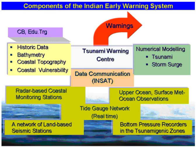 Functions as a Tsunami Service Provider (TSP) for 28 Indian Ocean Rim countries.
- Part of the Indian Ocean Tsunami Warning & Mitigation System (IOTWMS),
- Key Components
- Seismic Monitoring Network:
- Tracks seismic activity in real time, integrating data from national and global networks.
- Bottom Pressure Recorders (BPRs):
- Detects minute changes in water pressure; 12 BPRs installed in the Indian Ocean.
- Tide Gauges and Radar Systems:
- Monitors coastal water levels to confirm tsunami presence.
- Decision Support System (DSS):
- Automatically generates and disseminates alerts via SMS, email, and mobile applications (e.g., SAMUDRA app).
- Preparedness Measures
- Regular mock drills and capacity-building workshops.
- Implementation of the UNESCO-IOC Tsunami Ready Program:
- Villages like Venkatraipur and Noliasahi in Odisha were recognized as “Tsunami Ready” in 2020.
- Achievements
- India now ranks as one of the five countries with advanced tsunami warning systems, alongside the U.S., Japan, Chile, and Australia.
- Can issue tsunami advisories within 10 minutes of occurrence of an earthquake.
- Collaboration and Technology
- INCOIS collaborates with ISRO and NDMA to enhance communication systems.
- NAVIC Satellite Integration: Ensures real-time alerts for coastal communities.
Check Out UPSC NCERT Textbooks From PW Store
About IOC-UNESCO and Tsunami Ready Recognition Programme (TRRP)
- The Intergovernmental Oceanographic Commission of UNESCO (IOC/UNESCO) promotes international cooperation in marine sciences to improve management of the ocean, coasts and marine resources.
- The IOC is in charge of coordinating the United Nations Decade of Ocean Science for Sustainable Development 2021-2030, the “Ocean Decade”.
- UNESCO-IOC Tsunami Ready Recognition Programme (TRRP): The TRRP enhances community preparedness for tsunamis through education, training, and response planning.
- Communities are evaluated by IOC-UNESCO on 12 specific indicators.
|
Challenges with Early Warning Systems
- Detection Limitations in Near-Field Tsunamis: Tsunamis generated near coastlines allow minimal time for detection and warning dissemination.
- The Hunga Tonga-Hunga Ha’apai volcanic eruption 2022 produced waves that reached nearby islands within minutes, overwhelming the warning systems.
- Lack of Coverage in Some Regions: Many coastal nations do not have comprehensive tsunami warning systems.
- In East Africa, countries like Somalia remain vulnerable due to limited monitoring capabilities.
- Technological and Maintenance Challenges: Systems like DART buoys and tide gauges require regular maintenance, which can be costly and logistically challenging.
- Several DART buoys in the Indian Ocean were reported non-functional in 2018, potentially reducing the efficacy of warnings.
- Delay in Communication and Decision-Making: Early warning systems require efficient communication networks to disseminate alerts to authorities and the public promptly.
- During the Indian Ocean-wide tsunami exercise (IOWave23), gaps were identified in local-level communication systems, delaying evacuation orders despite mock warnings reaching regional centers
- Public Awareness and Response Gaps: Even with timely warnings, unprepared communities may fail to respond appropriately.
- In some parts of Sri Lanka and Thailand during the 2004 tsunami, people did not recognize natural warning signs, such as sea recession, leading to higher casualties.
- Integration of Data from Multiple Sources: Combining real-time data from seismic stations, BPRs, and tide gauges is complex and may cause delays.
- Inconsistencies in data interpretation during smaller tsunamis can lead to false alarms, eroding public trust in the warning system.
- After Alaska Earthquake 2021, a tsunami warning issued after an 8.2 magnitude earthquake caused panic but was later canceled when no significant waves were observed.
Way Forward for Managing Tsunami Impacts and Enhancing Early Warning Systems
- Strengthen Monitoring Infrastructure: Expand networks of seismic stations, tide gauges, and DART buoys, particularly in underserved regions like East Africa and the Arabian Sea.
- Incorporate advanced technologies like AI and machine learning for real-time tsunami modeling and enhanced prediction accuracy.
- Enhance Community Resilience: Conduct regular mock drills, public awareness campaigns, and capacity-building workshops in vulnerable coastal regions.
- Scale up successful programs like UNESCO-IOC’s Tsunami Ready initiative in countries across the Indian Ocean.
- Integrate Nature-Based Solutions: Restore and protect natural barriers like mangroves, coral reefs, and sand dunes to reduce the energy of tsunami waves.
- The presence of mangroves significantly mitigated impacts during the 2004 tsunami in regions like Odisha, India.
- Promote Regional and Global Collaboration: Enhance data-sharing and joint preparedness exercises among Indian Ocean Rim countries.
- Strengthen coordination through regional centers like the Indian Tsunami Early Warning Centre (ITEWC).
- Incorporate Risk Reduction in Coastal Development: Integrate tsunami risk assessments into urban planning and coastal development projects.
- Build resilient infrastructure, including elevated shelters and tsunami-resistant structures, particularly in high-risk zones.
- Mitigate Financial Risks: To mitigate the risks, develop the mechanism like catastrophe bonds.
- A catastrophe bond is a financial instrument that transfers financial risk connected with exposure to natural disasters to capital market investors.
Enroll now for UPSC Online Classes
Conclusion
An integrated approach combining technology, natural barriers, public engagement, and international cooperation is essential to mitigate tsunami impacts and enhance early warning systems. Strengthening preparedness and response capacities will ensure long-term resilience for coastal communities.
![]() 26 Dec 2024
26 Dec 2024



 Speed and Propagation: In deep oceans, tsunamis can travel at speeds up to 800 km/h, comparable to the speed of a jet aircraft.
 Functions as a Tsunami Service Provider (TSP) for 28 Indian Ocean Rim countries.