The ₹72,000-crore Great Nicobar Project faces controversy as the Tribal Council alleges false certification of settled forest rights under the Forest Rights Act, 2006, enabling illegal forest diversion.
About Great Nicobar Island Project
- Launched (2021): Mega development initiative at the southern tip of Andaman and Nicobar Islands (ANI).
- Components:
- International Container Trans-shipment Terminal (ICTT)
- Greenfield International Airport (both dual use: civilian & military)
- Township Development
- 450 Mega Volt Ampere (MVA) Gas and Solar-based Power Plant
- Implementing Agency: Andaman and Nicobar Islands Integrated Development Corporation (ANIIDCO).
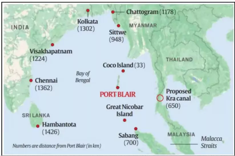
- Origin: Based on NITI Aayog report highlighting the island’s strategic location (equidistant from Colombo, Port Klang, Singapore).
- Jurisdiction: Port under Indian Navy; airport for both military and civilian purposes.
Reasons for Development
- Strategic Maritime Hub: Near Malacca Strait (primary link between Indian Ocean and Pacific Ocean).
- ICTT to integrate with the regional & global maritime economy.
- Proposed Site: Galathea Bay (southeast GNI, no human habitation).
- Enhancing Military Capabilities: Capacity for larger warships, aircraft, missile batteries, and troops.
- Strengthens surveillance & national security in the Bay of Bengal and Indian Ocean.
- Countering China: People’s Liberation Army Navy (PLAN) expanding in the Indo-Pacific.
- Concerns of Chinese presence at Malacca, Sunda, Lombok Straits.
- Coco Islands (Myanmar, 55 km from ANI) suspected Chinese facility.
- The GNI project strengthens India’s response.
- Addressing Regional Challenges: Piracy, smuggling, sea line of communication security, Chinese intrusions.
- Boosting Blue Economy: Establishing an economic hub & Special Economic Zone (SEZ).
- Supports free trade, reduces round-tripping, promotes marine resources-based growth.
About Great Nicobar Island
- Location: Great Nicobar is the southernmost part of the Andaman and Nicobar Islands (ANI). It stretches from Ranganatha Bay to Galathea Bay, further down to Indira Point (India’s southernmost tip), and extends up to Pemayya Bay.
- Geography: The Andaman and Nicobar Islands consist of 836 islands. These are divided into two groups – the Andaman Islands in the north and the Nicobar Islands in the south.
- They are separated by the 10° Channel, which is about 150 km wide.
- Strategic Significance: The island is situated close to the East–West International Shipping Corridor.
- It is equidistant from Colombo (Sri Lanka) to the southwest, and from Port Klang (Malaysia) and Singapore to the southeast, making it strategically vital for both trade and security.
- Inhabitants: Great Nicobar is home to indigenous tribes such as the Shompen and the Nicobarese (both of Mongoloid origin).
- In addition, settlers were relocated between 1968 and 1975, comprising retired servicemen and their families from states such as Punjab, Uttar Pradesh, Bihar, Maharashtra, Andhra Pradesh, Karnataka, and Tamil Nadu.
- Biodiversity: The island is covered with tropical wet evergreen forests and has a rich variety of fauna, including 14 species of mammals, 71 species of birds, 26 species of reptiles, 10 species of amphibians, and 113 species of fish.
- The Leatherback Sea Turtle is considered the emblematic species of the island.
Tribes in Great Nicobar Islands
- Shompen: Around 250 individuals, mostly live in interior forests in isolation.
- Predominantly hunter-gatherers.
- Classified as a Particularly Vulnerable Tribal Group (PVTG) within the list of Scheduled Tribes.
- Have their own distinct language.
- Nicobarese: Engage in farming and fishing.
- Two groups: Great Nicobarese and Little Nicobarese.
- Use different dialects of the Nicobarese language.
- Great Nicobarese: Lived along the southeast and west coast until the 2004 tsunami; later resettled in Campbell Bay. The current population is about 450.
- Little Nicobarese: Population is about 850; mostly in Afra Bay (Great Nicobar), also in Pulomilo and Little Nicobar islands.
|
About Particularly Vulnerable Tribal Group (PVTG)
- PVTGs, among tribal groups, face heightened vulnerability. Consequently, more developed and assertive tribal groups receive a significant portion of tribal development funds, leaving PVTGs in greater need of targeted funding for their development.
- History: In 1975, the Government of India designated 52 tribal groups as PVTGs based on the Dhebar Commission’s recommendations. Currently, out of 705 Scheduled Tribes, there are 75 recognized as PVTGs.
About Forest Rights Act, 2006 (Scheduled Tribes and Other Traditional Forest Dwellers (Recognition of Forest Rights) Act, 2006)
- Objective: To recognize and vest forest rights and occupation rights in forest land to Scheduled Tribes (STs) and Other Traditional Forest Dwellers (OTFDs) who have been residing in forests for generations but lacked legal recognition.
- To correct historical injustice done to tribals and forest-dependent communities.
- Key Provisions:
- Individual Rights: Right to hold and live in forest land under individual or common occupation for habitation or self-cultivation (up to 4 hectares).
- Community Rights: Rights over minor forest produce (MFP), grazing, fishing, water bodies, seasonal resources, and traditional cultural practices.
- Right to protect, regenerate, or manage any community forest resource for sustainable use.
- Development Rights: Right to access basic amenities (schools, hospitals, roads) within forest areas without displacement.
- Role of Gram Sabha: Gram Sabha is the key authority to initiate, verify, and approve claims for forest rights.
- Safeguards: No eviction of forest dwellers until recognition and verification of rights are complete.
- Significance:
-
- Empowers marginalized tribal communities.
- Strengthens participatory forest management.
- Balances livelihood security with forest conservation.
|


 23 Aug 2025


.png)


 Current Affairs


 GS Foundation
 Optional Course
 Combo Courses
 Degree Program