Hayli Gubbi Volcano

25 Nov 2025

Hayli Gubbi Volcano

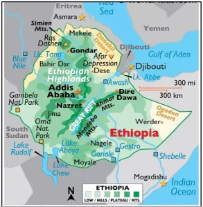
Volcanic ash from Ethiopia’s Hayli Gubbi eruption has drifted toward multiple countries, prompting DGCA to instruct Indian airlines to avoid ash-affected airspace and altitudes.

About Hayli Gubbi volcano

  • The Hayli Gubbi volcano is a shield volcano in Afar, Ethiopia, and a member of the Erta Ale Range.
    • The Erta Ale Range is a volcanic chain in Ethiopia’s Afar Region, part of the East African Rift System where tectonic plates are pulling apart

About the East African Rift

  • The East African Rift (EAR) is a major continental rift system where the African Plate is splitting into the Nubian and Somali plates.
  • Location: It extends from the Red Sea through Ethiopia and down to Mozambique.

  • Recent Eruption: It erupted in 2025 sending massive ash plumes across East Africa and beyond.
    • The eruption sent ash plumes up to 14 km into the atmosphere.

Reasons of recent eruption

  • Rifting-driven magma buildup: Movement of the African and Arabian plates widened the East African Rift, allowing hot mantle material to rise and slowly recharge magma beneath Hayli Gubbi.
  • Pressure from gas-rich magma: Long-term accumulation of basaltic to silica-rich magma increased pressure, with trapped gases leading to an explosive release.
  • Crustal faults opening a pathway: New fractures likely opened a conduit to the surface, triggering the sudden eruption after 12,000 years of dormancy.

About Ethiopia

Hayli Gubbi Volcano

  • Ethiopia is a landlocked East African country covering 1,104,300 sq. km, known for its ancient history and diverse landscapes.
  • It borders with six countries:
    • Eritrea (north), Djibouti (northeast), Somalia (east), Kenya (south), South Sudan (west) and Sudan (northwest)
  • The country has one of Africa’s most rugged and complex topographies, consisting of:
    • Rift Valley
    • Western & Eastern Highlands
    • Western & Eastern Lowlands
  • The North Central massifs host Ethiopia’s highest peak, Mount Ras Dejen (4,533 m).
  • Lake Tana, the largest lake, lies at about 1,800 m altitude.
  • The Western Lowlands lie along Sudan’s border with elevations around 1,000 m, drained by rivers like the Blue Nile and Baro.
  • The Afar Depression houses the Kobar Sink (125 m), one of the lowest points in Africa.

Need help preparing for UPSC or State PSCs?

Connect with our experts to get free counselling & start preparing

Aiming for UPSC?

Download Our App

      
Quick Revise Now !
AVAILABLE FOR DOWNLOAD SOON
UDAAN PRELIMS WALLAH
Comprehensive coverage with a concise format
Integration of PYQ within the booklet
Designed as per recent trends of Prelims questions
हिंदी में भी उपलब्ध
Quick Revise Now !
UDAAN PRELIMS WALLAH
Comprehensive coverage with a concise format
Integration of PYQ within the booklet
Designed as per recent trends of Prelims questions
हिंदी में भी उपलब्ध

<div class="new-fform">


    </div>

    Subscribe our Newsletter
    Sign up now for our exclusive newsletter and be the first to know about our latest Initiatives, Quality Content, and much more.
    *Promise! We won't spam you.
    Yes! I want to Subscribe.