Revised Earthquake Design Code, 2025

1 Dec 2025

Revised Earthquake Design Code, 2025

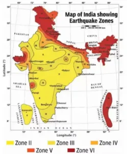
India has released an updated seismic zonation map under the revised Bureau of Indian Standards (BIS) Earthquake Design Code.

What is a Seismic Zonation Map?

  • A Seismic Zonation Map is a scientific map that divides a country or region into different seismic hazard zones, based on the likelihood and intensity of earthquakes.
  • It helps assess earthquake risk, guide building codes, and support disaster preparedness.
  • It is published by the Bureau of Indian Standards (BIS).

Key Features of the Revised Zonation Map

Revised Earthquake Design Code

  • Introduction of Zone VI: The new seismic map introduces Zone VI, the highest-risk seismic classification, and places the entire Himalayan arc stretching from Jammu & Kashmir and Ladakh to Arunachal Pradesh within this zone.
  • Enhanced Geographic Coverage:
    • The revised map now classifies 61% of India’s landmass under moderate to high hazard zones, an increase from 59% in earlier versions.
      • 75% of India’s population is now in seismically active regions
    • The southern peninsula shows only minor refinements, maintaining a stable hazard profile due to relatively stable tectonic conditions.
  • Boundary Rule Enhancement:
    • Under the updated rules, any town or settlement located on the boundary between two seismic zones is automatically placed in the higher-risk zone.
    • This change ensures zoning decisions reflect geological risk rather than administrative boundaries.
  • Revised Earthquake Design CodeScientific Methodology: 
    • The updated seismic hazard map is based on Probabilistic Seismic Hazard Assessment (PSHA), an internationally recognised methodology.
    • It incorporates factors such as ground-shaking attenuation with distance, regional tectonic regimes, and the lithological characteristics of underlying rock formations.
  • Mandatory Safety Measures:
    • The new code mandates safety norms for parapets, ceilings, overhead tanks, façades, HVAC systems, and similar elements, especially when their weight exceeds 1% of the building’s total load.
    • In addition, buildings located near active fault lines must be designed to withstand pulse-like ground motions, which are characteristic of near-fault earthquakes.
  • Southward Rupture Modelling: 
    • The revised map acknowledges that ruptures along the Himalayan Frontal Thrust (HFT) can propagate southwards, affecting densely populated foothill settlements such as Dehradun (near Mohand).
    • This inclusion reflects a better understanding of rupture dynamics that extend beyond traditional fault-line mapping.
  • Exposure Mapping:
    • The map now integrates population density, infrastructure concentration, and socioeconomic vulnerability through the PEMA (Population Exposure Mapping and Analysis) method.
    • This ensures seismic zoning considers hazard + human exposure, crucial for rapidly urbanising regions.

Why the Himalayas Are in the Highest Danger Zone?

  • Active Plate Collision: The Himalayas sit on one of the world’s most active tectonic collision zones, where the Indian Plate pushes into the Eurasian Plate at 5 cm per year, continually building immense stress.
  • Geologically Young and Unstable Terrain: Being geologically young, the Himalayas experience active folding, fracturing, and uplift, making the region inherently unstable.
  • Multiple Major Fault Systems: Faults such as the Main Frontal Thrust, Main Boundary Thrust, and Main Central Thrust are capable of generating large, destructive earthquakes.
  • Seismic Gaps and Stored Energy: Long seismic gaps with centuries without major quakes indicate significant accumulated strain, heightening earthquake potential.

Check Out UPSC CSE Books

Visit PW Store
online store 1

Implications for Infrastructure and Planning

  • Stricter Building Standards: Engineers and planners must adopt more rigorous design codes for buildings, bridges, and critical infrastructure in vulnerable zones.
  • Retrofitting Urgency: Existing structures in high-risk zones must undergo retrofitting to withstand potential high-magnitude earthquakes.
  • Restrictions on Hazardous Zones: The guidelines call for halting infrastructure expansion on soft sediments, active faults, and liquefaction-prone areas.

About BIS Earthquake Design Code

  • The Bureau of Indian Standards (BIS) issues national standards for earthquake-resistant design of buildings and structures under the IS 1893 series.
  • It provides scientific guidelines to ensure that buildings can withstand seismic forces and reduce collapse risk during earthquakes.

Need help preparing for UPSC or State PSCs?

Connect with our experts to get free counselling & start preparing

Aiming for UPSC?

Download Our App

      
Quick Revise Now !
AVAILABLE FOR DOWNLOAD SOON
UDAAN PRELIMS WALLAH
Comprehensive coverage with a concise format
Integration of PYQ within the booklet
Designed as per recent trends of Prelims questions
हिंदी में भी उपलब्ध
Quick Revise Now !
UDAAN PRELIMS WALLAH
Comprehensive coverage with a concise format
Integration of PYQ within the booklet
Designed as per recent trends of Prelims questions
हिंदी में भी उपलब्ध

<div class="new-fform">


    </div>

    Subscribe our Newsletter
    Sign up now for our exclusive newsletter and be the first to know about our latest Initiatives, Quality Content, and much more.
    *Promise! We won't spam you.
    Yes! I want to Subscribe.