As of February 2026, India has built a regulated drone ecosystem with 38,500+ registered drones (UIN), 39,890 DGCA-certified remote pilots, and 244 approved training organisations.
- Drone technology has become a key enabler of efficient and responsive public service delivery in India.
- Integrated into flagship government schemes such as Survey of Villages and Mapping with Improvised Technology in Village Areas (SVAMITVA) and Pradhan Mantri Fasal Bima Yojana (PMFBY), drones are enhancing agility, precision, and transparency in governance.
What Are UAVs?
- Unmanned Aerial Vehicles (UAVs), commonly known as drones, are aircraft that operate without a human pilot on board.
- They can be controlled remotely by an operator or operate autonomously using pre-programmed flight paths and AI-based navigation systems.
Types of UAVs
- Based on Size:
- Micro and Nano UAVs: Small drones used for close-range surveillance (e.g., quadcopters).
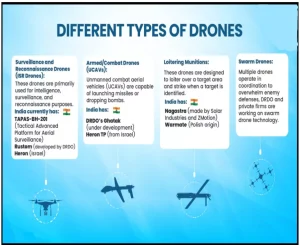 Tactical UAVs: Medium-sized drones for military reconnaissance and border patrol.
- Strategic/Combat UAVs: Large drones with long endurance and combat capabilities (e.g., MQ-9 Reaper, Bayraktar TB-2).
- Based on Function:
- Surveillance UAVs: Used for intelligence gathering and border security.
- Combat UAVs (UCAVs): Armed drones that carry missiles and bombs for military strikes.
- Logistics UAVs: Used to transport supplies, medicines, or weapons in remote areas.
- Commercial UAVs: Used for photography, agriculture, and delivery services.
- Based on Operational Range:
- Short-Range UAVs: Can fly within a few kilometers, used for local reconnaissance.
- Medium-Range UAVs: Operate within 100-300 km, commonly used for tactical missions.
- Long-Endurance UAVs: Can stay airborne for 24 hours or more, used for strategic operations.
Transformation of Public Service Delivery through Drone Technologies
- Agriculture and Farmer Services: The Namo Drone Didi Scheme (Nov 2023) provides drones to women SHGs to boost farm efficiency, productivity, reduce costs, and create sustainable livelihoods.
- Land Mapping: Survey of Villages and Mapping with Improvised Technology in Village Areas (SVAMITVA) Scheme uses drones to map rural abadi areas, helping settle land disputes and improve access to bank credit.
- Aerial Mapping for Highway Development: The National Highways Authority of India (NHAI) mandates monthly drone-video recordings for all highway projects.
- Contractors are required to upload both current-month and prior-month footage onto NHAI’s Database for month-to-month comparison.
- Use of Drones in Disaster Management and Emergency Response: Drones are helping India respond better during natural disasters.
- For Example: The North East Centre for Technology Application and Reach (NECTAR) has developed a special drone system for disaster situations.
- Railway Drone Monitoring: The Ministry of Railways has directed all its zones and divisions to deploy UAVs/drones for enhanced monitoring and maintenance of railway tracks, bridges, and other infrastructure.
- For Example: Zonal railways and public sector units have also installed UAV systems to support regular maintenance and infrastructure management.
- Drones in Defence: Drones play a key role in India’s defence, helping the armed forces watch borders, gather intelligence, and carry out precise strikes.
- For Example: During Operation SINDOOR, Indian drones and loitering munitions destroyed enemy targets safely and accurately.
Policy Framework for Drones
- Drone Rules, 2021 and Drone (Amendment) Rules 2022 & 2023: The Drone Rules, 2021, along with the amendments introduced in 2022 and 2023, have significantly liberalised India’s drone ecosystem.
- Regulatory procedures were simplified, with forms reduced from 25 to 5 and approval requirements lowered down from 72 to just 4.
- Fees were rationalised and delinked from drone size.
- Civilian drone operations were permitted for drones weighing up to 500 kg, thereby expanding commercial and industrial applications.
- Nearly 90% of Indian airspace was declared a Green Zone for drone operations, allowing flights up to 400 feet.
- Production Linked Incentive (PLI): PLI scheme for drones and drone components has an approved outlay of ₹120 crore. It aims to promote high-value domestic manufacturing by encouraging local production.
- GST on drones: GST on drones was reduced to a uniform 5% in September 2025. Earlier tax rates of 18% and 28% were removed. This simplified taxation supports wider commercial and personal use of drones.
- Ecosystem Development and Capacity Building through Flagship Programmes:
- Platforms such as Bharat Drone Shakti, Bharat Drone Mahotsav and the Drone International Expo promote Drone-as-a-Service (DaaS) start-ups and new business models.
Challenges for India
- Border Security: Pakistan frequently uses small UAVs to transport arms and drugs across the border. India needs cost-effective ways to counter these threats without resorting to expensive missiles.
- Neighbouring UAV Deployments: Bangladesh’s deployment of Turkish Bayraktar TB-2 UAVs near the Indian border highlights the need for a strategic response to larger, more advanced drones.
- Escalation Management: India must develop protocols to address UAV incursions without escalating tensions, especially with neighbours like Pakistan and China.
Way Forward
- Develop Cost-Effective Countermeasures: India should invest in affordable anti-drone technologies, such as jamming systems or drone interceptors.
- Enhance UAV Capabilities: India needs to expand its own UAV fleet for surveillance, reconnaissance, and combat roles.
- International Collaboration: Partnering with other nations to develop advanced UAV technologies and countermeasures can strengthen India’s position.
Conclusion
- Through progressive regulations, financial incentives, and dedicated capacity-building initiatives, India has created a comprehensive ecosystem that accelerates drone adoption and manufacturing.
- Simplified Drone Rules, PLI support, GST cuts, Digital Sky, and skill programs are driving widespread drone use and building a self-reliant, future-ready sector.


 19 Feb 2026


.png)


 Current Affairs


 GS Foundation
 Optional Course
 Combo Courses
 Degree Program