Udaan, Prahaar, Q&A Bank etc.
CA Magazines & Editorials
Afghanistan Earthquake 2025 struck Herat with 6.3 magnitude, causing destruction and casualties. Explore causes, impacts, rescue efforts, and preparedness strategies.
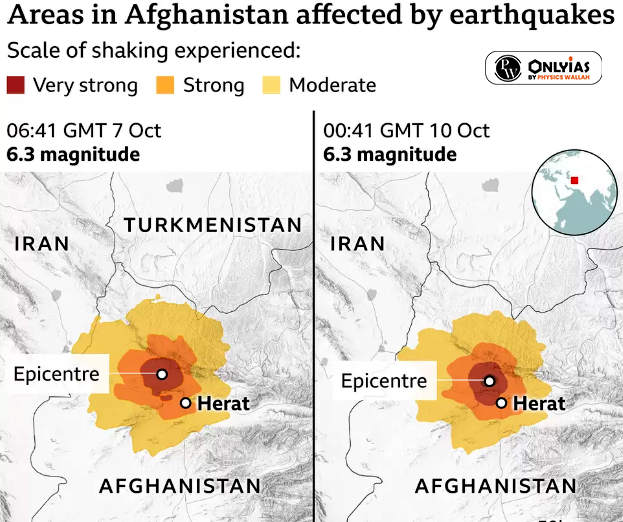
Context: Afghanistan Earthquake: A 6.0 magnitude earthquake has struck the Herat province in Afghanistan, resulting in severe destruction.
On September 1, 2025, the Afghanistan Earthquake 2025 struck near Jalalabad with a 6.0 magnitude tremor at 11:47 p.m. The U.S. Geological Survey reported its Afghanistan earthquake epicenter about 17 miles east-northeast of Jalalabad at a shallow depth of just 5 miles, making the impact more destructive. Buildings collapsed, roads cracked, and hundreds were reported dead or injured. This tragic event added significantly to the toll of Afghanistan earthquake death cases, with thousands displaced. Rescue teams and volunteers are racing against time, but blocked routes and debris are slowing relief operations in affected areas.
| P-waves (Primary waves) | S-waves (Secondary waves) | Surface waves |
|
|
|
| Richter scale |
|
| Moment magnitude scale |
|
| Modified Mercalli Intensity scale |
|
|
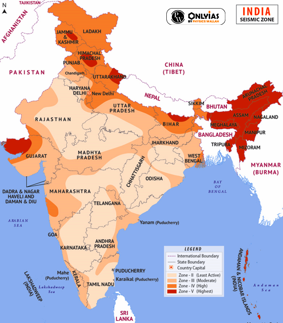
Guidelines issued by NDMA rest on six pillars of seismic safety for improving the effectiveness of earthquake management in India:
| Must Read | |
| NCERT Notes For UPSC | UPSC Daily Current Affairs |
| UPSC Blogs | UPSC Daily Editorials |
| Daily Current Affairs Quiz | Daily Main Answer Writing |
| UPSC Mains Previous Year Papers | UPSC Test Series 2024 |
Explore SRIJAN Courses

The recent earthquake in Afghanistan had a magnitude of 6.3 and struck the Herat province.
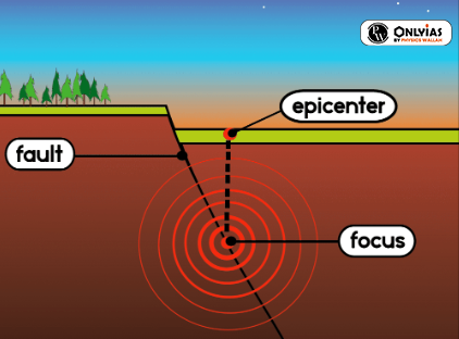
Afghanistan's location on the Eurasian Plate, surrounded by tectonic plates like the Arabian Plate and Indian Plate, and its position in the seismically active Hindu Kush mountain range make it prone to frequent earthquakes.
The Richter scale is a logarithmic scale that ranges from 1 to 10, with each unit increase representing a tenfold increase in ground shaking, while the Moment magnitude scale measures total energy and is more accurate for large earthquakes.
The International Day for Disaster Risk Reduction, observed on October 13, promotes global disaster risk reduction, with the 2023 theme focusing on "Early warning and early action for all."
Early warning systems can provide populations in earthquake-prone regions with seconds to minutes of notice, allowing them to take protective actions.
On September 1, 2025, a 6.0 magnitude earthquake struck near Jalalabad, Afghanistan, at a shallow depth of 5 miles, causing severe destruction.
It sits in the Hindu Kush mountains, where the Indian Plate collides with the Eurasian Plate, creating active fault lines.


Connect with our experts to get free counselling & start preparing
Join India’s trusted platform for expert guidance, quality content, proven success.
Learn anytime, anywhere.


India's leading UPSC coaching platform helping aspirants prepare for IAS, IPS, IFS and other Civil Services examinations with the best faculty and proven strategies.
<div class="new-fform">
</div>