Books

Bhagirathi River originates from Gaumukh Glacier in Uttarakhand and flows ~205 km through the Himalayas. Major tributaries include Kedar Ganga and Bhilangna. At Devprayag, it joins the Alaknanda to form the Ganga. Its basin is ecologically fragile. Tehri Dam and other hydropower projects support water, energy, agriculture, and pilgrimage.

The Bhagirathi River is one of the most sacred and geographically important rivers of India. It flows through the rugged Himalayas of Uttarakhand and forms the main headstream of the holy Ganga River.
Bhagirathi River originates from the Gaumukh glacier in Uttarakhand’s Garhwal Himalaya, and from there it flows through a mountainous course, meeting the Alaknanda River at Devprayag.
The Bhagirathi River represents the lifeline of the Garhwal Himalayas. Read on to learn about the Bhagirathi River origin, course, length, basin, tributaries, dams, and valley geography in a clear and exam-oriented way.
The Bhagirathi river origin lies high in the Garhwal Himalayas of Uttarakhand. The Bhagirathi River source Gaumukh Glacier is located near Gangotri, at an altitude of about 3,892 metres above sea level. Gaumukh literally means “cow’s mouth,” and it resembles the shape of a cow’s snout.
The Bhagirathi River emerges as a fast-flowing glacial stream from this glacier. Snowmelt from the surrounding peaks feeds the river throughout the year. This region remains frozen for several months, yet the river continues to flow due to sub-surface glacial movement.
Explore UPSC Foundation Courses

Explore UPSC Foundation Courses
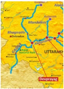
Bhagirathi River Map is provided below for easy understanding:
Gangotri is also a major pilgrimage site. According to Hindu belief, Goddess Ganga descended here on Earth. Because of this spiritual link, the Bhagirathi is worshipped as a divine river even before it becomes the Ganga.
The Bhagirathi River course begins at Gaumukh Glacier and flows south-westwards through the Himalayas. Initially, it moves through narrow gorges and rocky terrain. As it descends, the valley widens slightly near Uttarkashi.
The river then flows past Tehri, where the massive Tehri Dam is located. After this, it continues its journey toward Devprayag. The river flows about 193 kilometers before its major confluence. The total Bhagirathi river length is approximately 205 kilometres.
Throughout its course, the river maintains a strong current due to steep gradients. This makes it suitable for hydropower projects but also increases flood risks during heavy rainfall and cloudbursts.
The Bhagirathi river basin covers an area of roughly 6,921 square kilometers, including a large part of the Garhwal Himalayas. It includes snow-covered peaks, alpine meadows, forested slopes, and river terraces. The basin receives water from glaciers, rainfall, and seasonal snowmelt.
The drainage pattern is mainly dendritic, shaped by hard crystalline rocks. The highest point in the Bhagirathi river basin is Chaukhamba I peak.
The basin is ecologically sensitive and highly prone to landslides and earthquakes. Climate change has also affected glacier retreat in the upper basin. Despite these challenges, the basin supports agriculture, hydropower, and livelihoods for thousands of people.
Several streams and rivers join the Bhagirathi along its journey. The major Bhagirathi river tributaries include:
The Devprayag Sangam is one of the most important river confluences in India. Here, the Bhagirathi river and Alaknanda confluence takes place. After this meeting, the river is officially known as the Ganga.
The Devprayag confluence Ganga formation holds immense religious significance. Devprayag is one of the Panch Prayag of Uttarakhand. The clear waters of the Bhagirathi meet the comparatively sediment-rich Alaknanda, creating a visible colour contrast.
Geographically, although the Alaknanda is longer and carries more water, tradition recognises the Bhagirathi as the headstream of Ganga due to its sacred origin at Gaumukh.
Explore UPSC Prarambh Course

Explore UPSC Prarambh Course
The Bhagirathi River supports several hydropower projects. These projects help meet energy demands but also raise environmental concerns.
The Tehri Dam on Bhagirathi river is one of the tallest dams in India. The dam provides hydroelectric power, irrigation, and drinking water. However, it has also caused displacement, seismic concerns, and ecological impacts. Other smaller projects exist upstream, making the river heavily regulated.
Check Out UPSC CSE Books
Visit PW Store
The Bhagirathi River in Uttarakhand supports drinking water needs, agriculture, and hydropower generation in the state. The Bhagirathi valley is narrow and deep, shaped by strong glacial erosion. Steep slopes, landslide-prone zones, and fragile ecology define this region.
Despite these challenges, towns and villages have developed along the river banks for centuries. The Bhagirathi River also plays a major role in religious tourism. Pilgrims travelling to Gangotri, Uttarkashi, and Devprayag closely follow the river’s path.
Ready to boost your UPSC preparation? Join PW’s UPSC online courses today!
Explore UPSC Test Series

The Bhagirathi River's origin is the Gaumukh glacier, located in the Garhwal Himalayas of Uttarakhand.
The Bhagirathi River and Alaknanda confluence at Devprayag to form the Ganga River.
The Tehri Dam on Bhagirathi River is a significant project located at its confluence with the Bhilangna River.
The Bhagirathi River has an approximate length of 205 kilometers.


Explore SRIJAN Prelims Crash Course

Connect with our experts to get free counselling & start preparing
Books
Udaan (Prelims Wallah)
Prahaar (Mains Wallah)
Q&A Bank (Prelims & Mains)
Budget & Economic Survey
NCERT Wallah
Marks Booster
हिंदी माध्यम विशेष शृंखला
 Current Affairs
Monthly Current Wallah
Subject Wise Current Affairs
Editorial Analysis
Editorial PDFs
News of The Day
Download Our App


Download Our App
<div class="new-fform">
</div>
 GS Foundation
 Optional Course
 Combo Courses
 Degree Program