Books

Mahanadi River System is a major east-flowing river in central and eastern India. It begins in Chhattisgarh, flows through Odisha, gathers water from many tributaries, supports large irrigation and dam projects like the Hirakud Dam, and finally meets the Bay of Bengal. This river shapes agriculture, water supply, and power generation across the region.
Mahanadi River System is one of the major river systems of central and eastern India, known for its long course and wide river basin. Flowing through Chhattisgarh and Odisha, the river supports farming, daily water needs, and irrigation projects across the region.
Its steady flow has helped settlements grow along its banks for centuries. The river also connects forests, plains, and coastal areas, making it closely linked to the natural and economic life of the region.
The Mahanadi River starts from the Sihawa Hills in the Dhamtari district of Chhattisgarh, at an elevation of about 440 metres above sea level. Its name, which means “great river” in Sanskrit (maha = great, nadi = river), reflects its importance in the region. From its source, the river flows eastward across fertile plains, gradually gaining strength as several streams join it.
It is one of the longest rivers of peninsular India, covering a long distance before reaching the sea. The early course of the river passes through forested and tribal areas, shaping the landscape and local livelihoods.
The Mahanadi Map is provided below for better understanding:
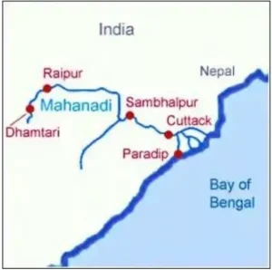
The Mahanadi course begins at its source in the Sihawa Hills and flows eastward across the plains of Chhattisgarh and Odisha for about 850–900 km. In its early stage, it flows briefly towards the north before turning east after meeting the Seonath River.
As it moves ahead, the river passes through important cities such as Raipur, Sambalpur, and Cuttack. On entering the Odisha plains, the river spreads out and slows down, carrying rich sediments.
Near Paradip, it finally empties into the Bay of Bengal, forming a wide and fertile delta that supports farming and settlements.
The Mahanadi Basin covers about 1,41,600 km² across several states. Most of the basin lies in Chhattisgarh (around 53%) and Odisha (around 47%), with smaller portions extending into Jharkhand, Maharashtra, and Madhya Pradesh.
The basin includes fertile plains, forested areas, and plateau regions, creating varied land use patterns. Its river network supports extensive canal systems that help farmers grow crops like rice and pulses. Seasonal rainfall over the basin strongly influences river flow, making water management an important concern.
The Mahanadi system receives water from many important tributaries:
Left-bank tributaries
Right-bank tributaries
These smaller rivers help sustain the Mahanadi throughout the year and feed its irrigation and water supply systems.
Several dams and river valley projects have been built on the Mahanadi and its tributaries to manage water flow, reduce flood impact, and support irrigation, drinking water supply, and power generation across the region.
The most famous project on the Mahanadi is the Hirakud Dam, located near Sambalpur in Odisha.
Several other dams and reservoirs support the river system:
The Mahanadi River System has a big impact on life and economy in central and eastern India:
Ready to boost your UPSC preparation? Join PW’s UPSC online courses today!
Explore UPSC Test Series

The Mahanadi river origin is from the Sihawa range of hills in Dhamtari district, Chhattisgarh.
The Mahanadi River drains into Bay of Bengal.
The total Mahanadi river length is about 851 km.
The Mahanadi River flows through Chhattisgarh and Odisha.


.png)


Enroll in SRIJAN Prelims Crash Course

Connect with our experts to get free counselling & start preparing
Books
Udaan (Prelims Wallah)
Prahaar (Mains Wallah)
Q&A Bank (Prelims & Mains)
Budget & Economic Survey
NCERT Wallah
Marks Booster
हिंदी माध्यम विशेष शृंखला
 Current Affairs
Monthly Current Wallah
Subject Wise Current Affairs
Editorial Analysis
Editorial PDFs
News of The Day
Download Our App


Download Our App
<div class="new-fform">
</div>
 GS Foundation
 Optional Course
 Combo Courses
 Degree Program