Books

Chenab River originates from the Chandra–Bhaga confluence in Himachal Pradesh, flows through Jammu & Kashmir and Punjab, and joins the Indus. Known as Asikni in ancient times, it is vital for hydropower, irrigation, and Indus Waters Treaty management.

The Chenab River is one of the major rivers of the Indus River system in South Asia. It originates in the upper Himalayas in Himachal Pradesh, formed by the confluence of the Chandra and Bhaga rivers near Tandi, and flows through Jammu & Kashmir before entering Pakistan, where it joins the Indus River. It is one of the five rivers of Punjab and plays an important role in irrigation and hydropower projects.
Chenab River is one of the largest tributaries of the Indus River Basin. It originates in the Lahaul and Spiti district of Himachal Pradesh and is formed by the confluence of the Chandra and Bhaga rivers. The Chandra River rises from the Chandra Tal Lake, located on the south-eastern side of the Bara Lacha Pass, while the Bhaga River originates from Suraj Tal on the opposite side of the pass. These two rivers meet at Tandi, about 8 km southwest of Keylong, after which the river is known as the Chenab.
From Tandi, the Chenab flows through the Lahaul Valley and enters the Pangi Valley of Chamba district near Bhujind. It leaves Himachal Pradesh at Sansari Nallah and enters the Paddar Valley of the Jammu and Kashmir Union Territory. The river traverses mountainous regions in Himachal Pradesh and both hilly and plain areas in Jammu and Kashmir. Finally, it merges with the Indus River as part of the Punjnad system at Mithankot in Pakistan. Within India, the Chenab River covers a distance of about 453 km, flowing through narrow valleys, rugged terrain, steep slopes, and deep gorges throughout its course.
Explore UPSC Foundation Courses

Explore UPSC Foundation Courses
| Aspect | Key Facts (Chenab-specific) |
| River System | Indus River System (Western River) |
| Source | Confluence of Chandra and Bhaga rivers |
| Source Location | Tandi, Lahaul & Spiti, Himachal Pradesh |
| Initial Name | Chandra–Bhaga |
| Ancient / Vedic Name | Asikni (Rigveda) |
| Greek Name | Acesines |
| Total Length | ~ 960 km |
| Indian Stretch | Himachal Pradesh → Jammu & Kashmir |
| Major J&K Districts | Doda, Ramban, Reasi |
| Course Nature | Deep gorges in J&K; wide plains in Punjab |
| Flow Direction | NW → SW |
| Entry into Pakistan | Punjab Province |
| Final Confluence | Joins Indus after merging with Sutlej |
| Major Tributaries | Jhelum, Ravi, Tawi, Ujh |
| Hydropower Importance | Highest among Indian western rivers |
| Major Projects | Salal, Baglihar, Dulhasti, Ratle, Pakal Dul |
| Irrigation Role | Extensive in Pakistan; limited in India |
| Treaty Status | Western River under Indus Waters Treaty (1960) |
| India’s Allowed Use | Hydropower & non-consumptive use |
| Exam Importance | Prelims maps + Mains (IWT, hydropower) |
The Chenab river origin lies in the higher Himalayas of Himachal Pradesh. It is formed by the confluence of two major headwaters:
These two rivers meet at Tandi, near the Bara-lacha Pass in the Lahaul and Spiti region. After this confluence, the river is known as the Chenab. Therefore, the Chenab river source is considered the Chandra–Bhaga confluence rather than a single glacier.
The river flows at a high altitude initially, carving deep valleys and gorges, which later become ideal locations for hydropower projects.
Confluence of Chandra and Bhaga
In ancient Indian texts, the Chenab River was known by different names:
The name Asikni appears in the Rigveda and means “dark-colored” or “black,” referring to the dark waters of the river. In Greek historical records from the time of Alexander the Great, the river was called Acesines.
The ancient name Asikni highlights the river’s historical importance in early Indian civilization and Vedic geography.
The Chenab River course passes through varied terrain, making it one of the most dynamic rivers of North India and Pakistan.
Finally, the Chenab river joins Indus after merging with the Sutlej River in Pakistan, contributing significantly to the Indus basin.
The Chenab river length is approximately 960 kilometres, making it one of the longer tributaries of the Indus River. Out of this total length:
Its long course allows it to drain a large catchment area and support extensive irrigation systems.
Explore UPSC Prarambh Course

Explore UPSC Prarambh Course
The Chenab river basin covers parts of:
The basin includes mountainous regions, valleys, and fertile plains. Snowmelt from glaciers and seasonal rainfall are the main sources of water. The basin is agriculturally rich and densely populated in the lower stretches, especially in Punjab.
The Chenab river tributaries strengthen its flow and expand its basin. Major tributaries include:
These tributaries are essential for maintaining the river’s discharge and supporting irrigation and hydropower activities.
The Chenab River in Jammu and Kashmir is especially significant due to its geography and strategic importance. The river flows through districts such as Doda, Ramban, and Reasi, forming deep gorges and valleys.
This stretch has high hydropower potential and hosts several major projects. The rugged terrain also makes dam construction challenging, increasing both engineering complexity and geopolitical sensitivity.
The Chenab River in Punjab flows through Pakistan’s Punjab province, where it becomes a lifeline for agriculture. The river feeds an extensive canal network that supports crops such as wheat, rice, and sugarcane.
Historically, Punjab’s prosperity has depended heavily on rivers like the Chenab, Ravi, and Sutlej, making the region one of the most fertile agricultural belts in South Asia.
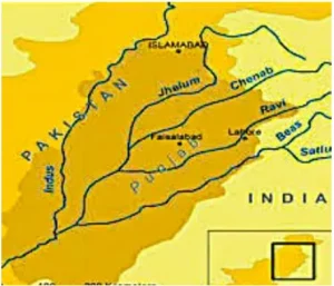
A Chenab river map shows its journey from the Himalayas to the Indus plains. Geographically, the river acts as:
Understanding the river’s map is important for competitive exams, as it helps in visualising river systems, tributaries, and international boundaries.
The Chenab River is known for its major hydropower infrastructure. Several dams and projects have been constructed or planned along its course.
The major dams on the Chenab River are:
These projects fall under the category of Chenab river dams and projects, designed mainly for electricity generation rather than large-scale water storage.
The Chenab river hydropower projects are among the most important in northern India. The river’s steep gradient and strong flow make it ideal for power generation.
Key features:
These projects help meet regional electricity demand while complying with international water-sharing agreements.
The Chenab river irrigation system is especially developed in Pakistan’s Punjab region. Canals derived from the river support millions of hectares of farmland.
In India, irrigation use is more limited due to treaty restrictions, but the river still supports local agriculture in Jammu and Kashmir through traditional channels and small irrigation systems.
Check Out UPSC CSE Books
Visit PW Store
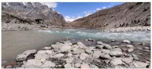
The Chenab river valley is known for its scenic beauty and rugged landscape. Surrounded by steep mountains, forests, and cliffs, the valley is both ecologically rich and geologically active.
The valley also serves as:
Under the Indus Waters Treaty (1960) between India and Pakistan, the Chenab is classified as a western river, along with the Indus and Jhelum. Pakistan has primary rights over its waters, while India is allowed limited use for:
This makes the Chenab a river of major geopolitical importance.
Ready to boost your UPSC preparation? Join PW’s UPSC online courses today!
Explore UPSC Test Series

The Chenab River originates in Himachal Pradesh from the confluence of the Chandra and Bhaga rivers near Tandi in the Lahaul region.
The ancient and Vedic name of the Chenab River is Asikni, meaning “dark river,” as mentioned in the Rigveda.
In India, the Chenab River flows through Himachal Pradesh and Jammu and Kashmir before entering Pakistan.
The Chenab River is approximately 960 km long, making it one of the major tributaries of the Indus River system.
Major tributaries of the Chenab River include the Jhelum, Ravi, Tawi, and Ujh rivers.
The Chenab is classified as a western river under the Indus Waters Treaty, giving Pakistan primary rights while allowing India limited use for hydropower and non-consumptive purposes.


Explore SRIJAN Prelims Crash Course

Connect with our experts to get free counselling & start preparing
Books
Udaan (Prelims Wallah)
Prahaar (Mains Wallah)
Q&A Bank (Prelims & Mains)
Budget & Economic Survey
NCERT Wallah
Marks Booster
हिंदी माध्यम विशेष शृंखला
 Current Affairs
Monthly Current Wallah
Subject Wise Current Affairs
Editorial Analysis
Editorial PDFs
News of The Day
Download Our App


Download Our App
<div class="new-fform">
</div>
 GS Foundation
 Optional Course
 Combo Courses
 Degree Program