An avalanche hit a Border Roads Organisation (BRO) project site near Mana Pass in Uttarakhand’s Chamoli district.
About Avalanche
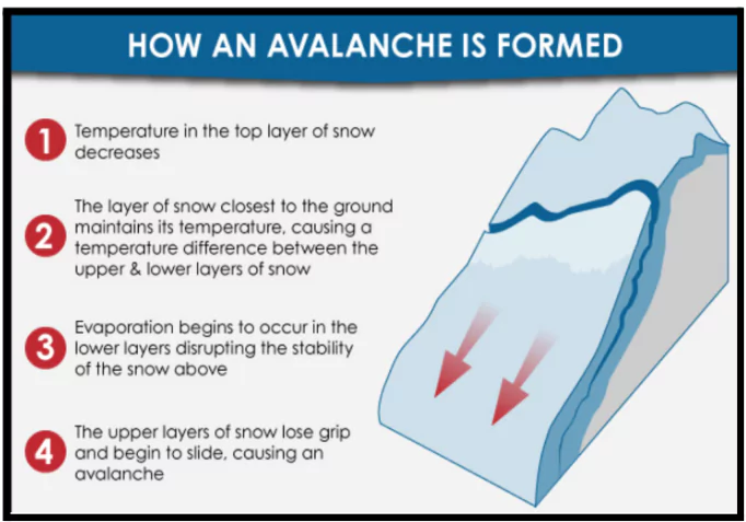
- Avalanche is a rapid descent of snow, ice, and debris down a mountain slope.It is triggered by natural or human-induced factors.
- It can cause widespread destruction, burying people, structures, and transport routes.
Types of Avalanches
- Loose Snow Avalanche: Occurs on steep slopes (>40°) with loosely bonded snow.
- Slab Avalanche: Large, cohesive snow layer fractures and slides. Most deadly, with speeds up to 100 km/h.
- Gliding Avalanche: The entire snowpack slides over smooth surfaces (e.g., rock).
Snow Avalanche Zones
- Red Zone – The most dangerous zone where snow avalanches are most frequent and have an impact pressure of more than 3 tonnes per square metre.
- Blue Zone – Where the avalanche force is less than 3 tonnes per square metre and where living and other activities may be permitted with connection of safe design but such areas may have to be vacated on warning.
- Yellow Zone – Where snow avalanche occur only occasionally
|
-
- Powder Avalanche: High-speed avalanche with suspended snow particles in the air.
- Wet Snow Avalanche: Triggered by melting snow due to temperature rise or rain.
Causes of Avalanches
- Heavy Snowfall and Wind: Rapid accumulation of snow adds weight and stress to the snowpack.
- Wind can transport snow to leeward slopes, creating unstable snowdrifts that are prone to avalanches.
 Mana Village Avalanche (Feb, 2025): Heavy snowfall for two days prior to the event increased the load on the snowpack, leading to the avalanche.
- Steep Slopes (30° to 45° Slope Angle): Avalanches are most likely on slopes with angles between 30° to 45°.
- Chamoli Avalanche (2021): A massive avalanche, caused by a chunk of glacier falling from a steep slope, led to flash floods, missing or dead over 200 people.
- Temperature Fluctuations and Melting: Rising temperatures or solar radiation cause the snowpack to melt and refreeze, weakening its bond.
- Rohtang Pass Avalanche (Mar 2019): Melting snow triggered an avalanche that affected road infrastructure and stranded tourists.
- Earthquakes and Vibrations: Seismic activity or vibrations disturb the snowpack, dislodging unstable layers.
- Sikkim Earthquake (2011): Triggered landslides and avalanches in the North Sikkim region.
Mana Pass
- Mana Pass, also known as Mana La, is known for being one of the highest motorable passes in the world. (Elevation of around 5,543 meters)
- Himalayan Location: Situated in the Greater Himalayas, near Badrinath in Uttarakhand, India.
- Border Crossing: Key connection between Tibet and Uttarakhand, and is the last Indian village before the Tibetan border.
- Significant trade route between India and Tibet for centuries
- The road to Mana Pass was constructed by the Border Roads Organisation (BRO) for the Indian military, between 2005 and 2010.
|
- Weak Snow Layers (Slab Formation): Weakly bonded snow layers beneath a cohesive slab of snow can collapse, causing the slab to slide.
- Slab avalanches are the deadliest, moving at speeds up to 100 km/h.
- Avalanche in Gulmarg (2010): A slab avalanche killed 17 Indian Army soldiers due to weak underlying snow layers.
- Deforestation and Construction Activities: Human activities, such as deforestation and infrastructure projects, destabilize slopes and increase avalanche risk.
- Char Dham Project, Uttarakhand: Large-scale construction in the fragile Himalayan zone has increased the frequency of avalanches and landslides.
- Human Activities: Skiing, snowboarding, and military exercises disturb snow layers, increasing instability.
- Siachen Avalanche (Feb 2016): Military operations in high-altitude areas triggered an avalanche, killing 10 soldiers.
Avalanches Prone Areas in India
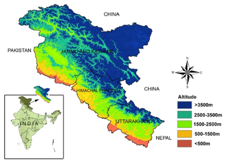
- The Himalayas are well known for the occurrence of snow avalanches, particularly the Western Himalayas i.e. the snowy regions of Jammu and Kashmir, Himachal Pradesh and Western Uttar Pradesh.
- Jammu and Kashmir – Higher reaches of Kashmir and Gurez valleys, Kargil and Ladakh and some of the major roads
- Himachal Pradesh – Chamba, Kullu- Spiti and Kinnaur vulnerable areas
- Uttarakhand – Parts of Tehri Garhwal and Chamoli districts are vulnerable areas.
Why Himalayan Regions Are Prone to Avalanches?
- Steep Slopes and Fragile Geology: The Himalayas are characterized by steep slopes (30° to 45°), which are ideal for avalanche formation.
- The region formed by the ongoing collision of the Indian and Eurasian plates, makes the terrain unstable and prone to landslides and avalanches.
- Heavy Snowfall and Snow Accumulation: The Himalayas receive heavy snowfall during winter, especially in higher altitudes where snow accumulates rapidly.
- Temperature Fluctuations and Freeze-Thaw Cycles: The Himalayan region experiences rapid temperature fluctuations, especially between day and night.
- High Seismic Activity and Earthquakes: The Himalayan region lies in Seismic Zones IV and V, making it prone to earthquakes.
- Climate Change and Global Warming: Rising global temperatures are causing glacial retreat and increased melting of snow and ice in the Himalayas.
- Unplanned Construction and Deforestation: Unregulated construction and deforestation in the fragile Himalayan ecosystem weaken slope stability.
Consequences and Impact of Avalanches
- Loss of Life and Injuries: Avalanches cause suffocation, trauma, and hypothermia.
- Destruction of Infrastructure and Property: Avalanches can bury roads, railways, buildings, and bridges, cutting off essential communication and transport links.
- Disruption of Communication and Utilities: Avalanches damage power lines, communication networks, and water supply systems.
- Environmental Hazards: Melting snow from avalanches increases water runoff, leading to landslides and flash floods in downstream areas.
- Economic Impact: Avalanches disrupt tourism, damaging infrastructure and affecting the livelihoods of local communities.
Protection Measures Against Avalanches
- Snow Barriers and Fences: Snow fences and barriers are installed on avalanche-prone slopes to reduce wind speed and control snow accumulation.
- These barriers stabilize snow layers, preventing their sudden collapse.
- Types:
- Rigid Snow Fences: Reduce wind speed and allow snow to accumulate gradually.
- Flexible Barriers: Absorb and dissipate avalanche energy, minimizing impact.
- Deflecting Structures (Avalanche Deflectors and Diversion Dams): Deflectors and diversion dams redirect avalanche flow away from populated areas and critical infrastructure.
- These structures channel snow to safer zones, reducing the impact on vulnerable regions.
- Types:
- V-Shaped Deflectors: Split avalanche flow and divert it to both sides.
- Diversion Dams: Block and guide avalanches toward predetermined routes.
- Controlled Explosions and Artificial Avalanche Triggers: Controlled explosions trigger smaller, manageable avalanches before larger, uncontrollable ones can occur.
- Snow accumulation is reduced by inducing preemptive avalanches under controlled conditions.
- Methods:
- Gas Exploders: Remotely detonated devices that trigger avalanches.
- Avalanche Mortars: Shells fired into high-risk zones to loosen snowpacks.
- Avalanche Protection Tunnels and Galleries: Avalanche tunnels and galleries provide safe passage for vehicles and pedestrians through avalanche-prone zones.
- These structures are built with reinforced concrete and designed to withstand the impact of snow and debris.
- Example: Rohtang Tunnel (Atal Tunnel), Himachal Pradesh: Built to ensure year-round connectivity and protect travelers from avalanches.
- Slope Modification and Stabilization Techniques: Modifying slopes to reduce steepness and increase stability minimizes avalanche risks.
- Slope modification involves terracing, vegetation planting, and slope reinforcement.
- Techniques:
- Terracing: Reduces slope angle and snow accumulation.
- Snow Rakes: Prevent large snow slabs from forming.
- Zoning and Land Use Planning: Proper zoning and land-use regulations prevent construction in avalanche-prone areas.
- High-risk zones are classified based on avalanche hazard maps, and construction is restricted accordingly.
- Zoning Categories:
- Red Zone: High-risk area; construction prohibited.
- Blue Zone: Medium-risk area; restricted development with safety measures.
- Yellow Zone: Low-risk area; occasional avalanches possible.
- Community Training and Preparedness Programs: Educating local communities about avalanche risks and survival techniques improves disaster resilience.
- Community members are trained to recognize warning signs and follow Standard Operating Procedures (SOPs) during emergencies.
Global Best Practices for Avalanche Management: Lessons for India
Switzerland: Advanced Avalanche Forecasting and Monitoring
- Switzerland uses a highly advanced avalanche forecasting system operated by the Swiss Federal Institute for Snow and Avalanche Research (SLF).
- It integrates data from:
- Doppler Radars and Automatic Weather Stations (AWS) to monitor snowpack stability.
- Remote Sensing and Satellite Imagery to identify avalanche-prone zones.
- Crowdsourced Data from ski resorts and mountaineers for real-time updates.
Norway: Controlled Avalanche Triggering and Risk Mitigation
- Norway employs controlled avalanche triggering to prevent large, uncontrolled avalanches.
- Methods include:
- Gas Exploders: Trigger smaller avalanches by releasing gas explosions at strategic locations.
- Helicopter Bombing: Dropping explosives on unstable slopes to reduce snow buildup.
United States: Community-Based Avalanche Education and Awareness
- The U.S. Forest Service Avalanche Center (USFSAC) runs extensive community-based avalanche education programs across high-risk states.
- Key Features:
- Know Before You Go (KBYG) Program: Prepares outdoor enthusiasts with essential avalanche safety knowledge.
- Avalanche Safety App: Provides real-time updates, safety tips, and emergency contacts.
Japan: Climate-Resilient Infrastructure and Avalanche Deflectors
- Japan uses climate-resilient infrastructure and avalanche deflectors to protect settlements and transportation networks.
- Key structures:
-
- Avalanche Deflectors: Divert snow away from populated areas.
- Snow Retention Structures: Control snow buildup and prevent sudden release.
|
Government Initiatives for Avalanche Management and Mitigation in India
- National Disaster Management Authority (NDMA) Guidelines – 2009
- NDMA formulated the “Management of Landslides and Snow Avalanches” Guidelines (2009) to strengthen disaster preparedness and response.
- The guidelines focus on risk assessment, hazard zonation, and capacity building for avalanche-prone regions.
- Key Provisions:
- Hazard Zonation Mapping: Identification of high-risk avalanche zones.
- Early Warning Systems: Establishment of real-time monitoring systems using Doppler radars and remote sensing.
- Training and Capacity Building: Conducting awareness programs and mock drills for communities and disaster response teams.
- Border Roads Organisation (BRO) – Infrastructure Resilience
- BRO undertakes construction and maintenance of strategic roads and tunnels in avalanche-prone areas to ensure year-round connectivity.
- It incorporates avalanche protection structures in high-altitude regions to safeguard transportation networks.
- Key Projects:
- Atal Tunnel (Rohtang Tunnel), Himachal Pradesh: Built to ensure all-weather connectivity and protect commuters from avalanches.
- Zojila Tunnel, Jammu & Kashmir: Designed to withstand heavy snow and avalanche conditions, ensuring connectivity to Ladakh.
- National Remote Sensing Centre (NRSC) – Satellite-Based Monitoring
- NRSC, under ISRO (Indian Space Research Organisation), monitors avalanche-prone regions using satellite imagery and remote sensing data.
- It uses Cartosat, Sentinel-2, and Landsat imagery for real-time snow cover analysis and avalanche prediction.
- Key Activities:
- Avalanche Hazard Mapping: Identification of snow-covered zones with high avalanche potential.
- Real-Time Monitoring: Use of satellite data for continuous monitoring and early warning dissemination.
- State Disaster Management Authorities (SDMAs) – State-Level Preparedness
- SDMAs, established under the Disaster Management Act, 2005, implement state-level disaster management plans to mitigate avalanche risks.
- They coordinate with IMD, SASE, and NDMA for localized forecasting and community training.
- National Landslide and Avalanche Risk Mitigation Project (NLARMP)
- Launched under the Ministry of Home Affairs, NLARMP focuses on reducing the risk of landslides and avalanches through scientific research, capacity building, and infrastructure resilience.
- Key Components:
- Risk Mapping and Vulnerability Assessment: Identifying high-risk zones in collaboration with NRSC and SASE.
- Development of Early Warning Systems: Establishment of real-time monitoring systems for avalanche-prone regions.
- Avalanche Early Warning Systems (EWS)
- India Meteorological Department (IMD) Avalanche Forecasting System: IMD monitors and forecasts avalanches by tracking snowfall, slope stability, temperature fluctuations, and wind patterns.
- It uses Numerical Weather Prediction (NWP) models and historical data to predict avalanche-prone areas.
- Snow and Avalanche Study Establishment (SASE) – DRDO Initiative
- SASE, under DRDO, conducts avalanche research and forecasting using:
- Automatic Weather Stations (AWS): Monitors temperature, wind speed, and snow depth.
- Remote Sensing Data: Assists in mapping avalanche-prone areas.
- Provides avalanche warnings for high-altitude military zones and civilian areas.
- Remote Sensing and AI-Based Prediction Models: Remote sensing satellites (e.g., Cartosat, Sentinel-2, and Landsat) provide real-time imagery to identify snow accumulation and avalanche risks.
- Doppler Radar and Infrared Satellite Sensing (DrISS): Doppler radar and infrared satellite imaging detect snowpack density, velocity, and movement in real time.
Way Forward for Avalanche Management in India
- Strengthen Avalanche Early Warning Systems (EWS): Enhance real-time detection and forecasting capabilities by integrating Artificial Intelligence (AI) and Machine Learning (ML) with existing prediction models.
- Expand the network of Doppler Radars and Automatic Weather Stations (AWS) in avalanche-prone zones for continuous monitoring.
- Develop Climate-Resilient Infrastructure: Design and construct avalanche-resilient infrastructure to withstand harsh weather conditions in high-risk regions.
- Incorporate deflecting structures, snow barriers, and avalanche protection tunnels in vulnerable zones.
- Community-Based Disaster Preparedness and Awareness: Empower local communities in avalanche-prone areas through capacity-building programs, mock drills, and awareness campaigns.
- Educate residents, tourists, and workers on recognizing avalanche warning signs and following safety protocols.
- Integrate Remote Sensing and AI-Based Monitoring: Utilize satellite-based remote sensing technology and AI algorithms for real-time snowpack monitoring and hazard mapping.
- Establish an Avalanche Risk Mitigation Hub to analyze satellite imagery and detect early signs of slope instability.
- Enforce Strict Zoning and Land Use Regulations: Implement stringent land-use policies and hazard zonation to prevent unplanned construction in avalanche-prone regions.
- Restrict development in high-risk zones while promoting eco-sensitive construction in medium-risk areas.
- Strengthen Inter-Agency Coordination and Response Mechanism: Foster better collaboration between NDMA, IMD, SASE, BRO, SDMAs, and the Indian Army for an integrated approach to avalanche management.
- Establish a Unified Avalanche Response Mechanism (UARM) to streamline disaster response efforts.
Conclusion
Effective avalanche management in India requires a multi-pronged approach that integrates advanced forecasting, climate-resilient infrastructure, community awareness, and strict zoning regulations. By adopting global best practices and strengthening inter-agency coordination, India can significantly reduce avalanche-related risks and protect vulnerable communities in the Himalayan region.
Additional Reading: Uttarakhand Avalanche


 18 Mar 2025


.png)


 Current Affairs


 GS Foundation
 Optional Course
 Combo Courses
 Degree Program