Recently, a cloudburst over Uttarakhand’s Kheer Ganga river triggered flash floods in Dharali village, destroying homes, hotels, and infrastructure, causing casualties and livestock losses.
- A new Natural Hazards journal study by IIT Gandhinagar warns that climate change is shifting flash flood hotspots into semi-arid and low-risk regions of western India.
IIT Gandhinagar Study on Changing Flash Flood Patterns in India
- Hotspot Shift: Flood-prone areas are expanding beyond traditional zones into drier regions due to rising sub-daily rainfall and warmer temperatures that increase atmospheric moisture.
- Data Trends (2001–2020 vs. 1981–2000):
- Non-prone sub-basins with rising rainfall & streamflow: Increased from 51% to 66.5%.
- High-risk zones with declining wet hours: Decreased from 50.3% to 48.7%.
- Drivers: Increased extreme rainfall events and rapid streamflow rise.
- Risk Profile: Flash floods are the deadliest flood type in India, with 5,000+ annual deaths and severe socio-economic damage.
- National Disaster Management Authority (NDMA) Data: Over 40 million ha in India are flood-prone.
|
About Cloudburst
- Definition: A cloudburst is defined as “rainfall of 10 cm or more in one hour over a roughly 10 km x 10 km area.”
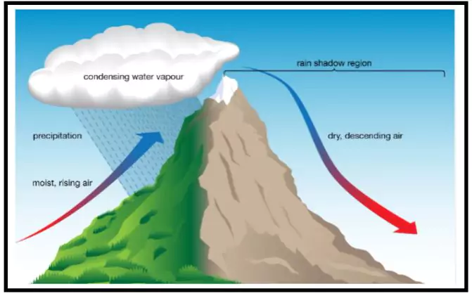
- Mechanism: Common in hilly areas due to a process called orographic lift:
- Warm air rises along mountain slopes.
- It expands due to low pressure at altitude and cools.
- Cooling causes condensation and release of moisture.
- If warm moist air keeps rising, it may delay rainfall until a large volume suddenly condenses and falls as torrential rain.
- Occurrence in India: In India, cloudbursts are frequently observed during the monsoon season, particularly over regions like the Himalayas, the Western Ghats, and the northeastern hill states.
- Linkage with Flash floods: Cloudbursts often result in flash floods and have become increasingly common from May-September when the southwest monsoon season prevails in much of the country.
- Impacts: Sudden, localized heavy rain.
- Often leads to flash floods and landslides due to drainage overload and rapid water accumulation.
- Prediction: Difficult to detect due to the small area and short time frame.
Historical Cloudburst Disasters in India
| Year |
Location |
Impact |
| 1908 |
Hyderabad, Telangana (then Hyderabad State) |
- A cloudburst caused the Musi River to overflow, killing an estimated 15,000 people and destroying tens of thousands of homes.
|
| 1970 |
Alaknanda River Valley, Uttarakhand |
- Massive floods and landslides washed away pilgrimage towns and a convoy of 30 buses.
|
| 1998 |
Malpa, Pithoragarh, Uttarakhand |
- A cloudburst-triggered landslide wiped out the village, killing 250 people, including pilgrims on the Kailash Mansarovar Yatra.
|
| 2005 |
Mumbai, Maharashtra |
- A cloudburst delivered over 950 mm of rain in less than 10 hours, paralyzing the city and causing over 1,000 deaths due to flooding.
|
| 2010 |
Leh, Ladakh |
- Flash floods caused by a cloudburst killed over 250 people and damaged a large number of houses and military facilities.
|
| 2013 |
Kedarnath, Uttarakhand |
- One of India’s most devastating natural disasters. A series of cloudbursts and glacial lake outbursts caused unprecedented flash floods and landslides, leading to over 5,700 deaths and widespread destruction of infrastructure.
|
| 2016 |
Pithoragarh & Chamoli, Uttarakhand |
- Multiple cloudbursts triggered flash floods and landslides, resulting in significant loss of life and property in several villages.
|
| 2023-2025 |
Various locations in Uttarakhand & Himachal Pradesh |
- A series of cloudbursts and flash floods have become increasingly common, leading to infrastructure collapse, loss of life, and disruption of pilgrimage routes.
|
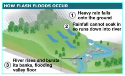
About Flash Floods
- Definition: According to the India Meteorological Department (IMD), a flash flood is a sudden, rapid flooding event that typically occurs within a short period, generally less than 6 hours, due to intense rainfall, often associated with cloudbursts or heavy thunderstorms.
- Causes of Flash Flood: Flash floods can be caused by factors other than rainfall:
| Natural Causes |
Anthropogenic Factors |
- Cloudbursts: Sudden, localized intense rainfall (>100 mm/hour) over a small area.
- Orographic effect in the Himalayas forces moist air upward, causing heavy, short-duration downpours – a key trigger for flash floods.
- Geological Instability: The young, fragile Himalayas with steep slopes and deep gorges are prone to landslides and debris flows, which worsen flooding.
- Glacial Lake Outburst Floods (GLOFs) – Rapid glacier melt from climate change forms unstable lakes. Breach of moraine dams can unleash massive floods downstream. Example: Chamoli flood (2021).
- Monsoon Season: Most flash floods occur June–September. Heavy rain saturates soil, reducing absorption and increasing surface runoff.
|
- Unplanned Development: Hotels, roads, and houses on riverbeds and unstable slopes block natural drainage, increasing disaster risk.
- Deforestation: Tree felling for development causes soil erosion, slope destabilization, and reduced rainwater absorption.
- Hydropower Projects: Dams and tunnels alter river flow, add seismic stress, and may fail during extreme weather, worsening floods.
|
Causes of Increased Cloudbursts and Flash Floods in Himalayan Regions:
- The increased frequency and severity of cloudbursts and flash floods in Himalayan states are a result of several natural and anthropogenic factors.
- These factors are interconnected and exacerbate each other, contributing to the vulnerability of the region.
- Orographic and Topographical Factors: The Himalayan region’s steep slopes and narrow valleys are particularly susceptible to cloudbursts.
- When moist air masses from the Bay of Bengal are forced to ascend over the mountains, they cool and condense, leading to intense rainfall over short periods.
- Recent Example: In June 2025, multiple cloudbursts in the Kullu and Kangra districts of Himachal Pradesh caused severe flash floods, destroying infrastructure and causing loss of life.
- Climate Change and Global Warming: Rising global temperatures have intensified the water cycle, increasing evaporation rates and atmospheric moisture content.
- The Himalayan region is warming at a rate higher than the global average, exacerbating the occurrence of cloudbursts and the intensity of rainfall. The average warming has been 1.6°C, against the average of 1°C temperature rise in India as a whole, and 1.1°C for the globe.
- Recent Example: The glacial melt and increased rainfall intensity observed in regions like Sikkim and Uttarakhand have been linked to global warming.
- Glacial Lake Outburst Floods (GLOFs): The rapid melting of glaciers due to rising temperatures has resulted in the formation of glacial lakes in the Himalayas. These lakes are particularly dangerous as their natural dams may fail, releasing massive volumes of water downstream.
- Recent Example: The Lhonak Lake outburst in Sikkim in 2023 caused significant flooding, infrastructure damage, and loss of life.
- Deforestation and Land Use Changes: Unregulated construction, deforestation, and encroachment on riverbeds have reduced the natural absorption capacity of the land.
- Urban sprawl and infrastructure development in flood-prone areas exacerbate the effects of heavy rains by increasing runoff.
- Recent Example: In August 2024, the Kullu-Manali region in Himachal Pradesh experienced devastating flash floods triggered by multiple cloudbursts.
- In Hilly States, the construction of roads, buildings, and other infrastructure in flood-prone areas has heightened the region’s vulnerability to such natural disasters.
Impacts of Cloudbursts and Flash Floods in India
- Human Impact: Sudden surges give little warning — for example, the 2013 Kedarnath disaster killed over 5,700 people (National Disaster Management Authority report).
- Displacement: Thousands rendered homeless; the 2021 Chamoli disaster displaced over 600 families.
- Health impacts: Outbreak of water-borne diseases post-floods (World Health Organization notes such risk increases up to three to four times after floods).
- Livelihood and Economic Loss: Standing crops destroyed; cloudbursts in Himachal Pradesh (2023) damaged over ₹1,000 crore worth of horticultural produce.
- Livestock losses: As per the Department of Animal Husbandry and Dairying, livestock losses during floods cause annual rural income losses of ₹300–500 crore.
- Tourism hit: Uttarakhand tourism lost ₹2,000+ crore in 2013 floods (State Tourism Department).
- Infrastructure Damage: Border Roads Organisation estimates floods in hilly states cause road repair costs exceeding ₹500 crore per year.
- Power and Telecommunications: Damage to hydroelectric projects — 2013 floods damaged over 25 small hydropower projects in Uttarakhand.
- Transport disruption: Himalayan roads remain blocked for weeks in some stretches (Ministry of Road Transport and Highways).
- Environmental Impact: India Meteorological Department and Indian Institute of Technology Roorkee report shows flash floods accelerate erosion by 30–40% in hilly catchments.
- Biodiversity loss: Wildlife habitats in river valleys destroyed — 2016 Pithoragarh cloudburst damaged key Himalayan musk deer zones.
- Sedimentation: Central Water Commission warns siltation in Tehri reservoir increased by 20% post-2013 due to debris from floods.
- Disaster Management Challenges: Comptroller and Auditor General of India (2022) found gaps in real-time weather data coverage in remote Himalayan areas.
- Access issues: National Disaster Management Authority notes 40% of affected villages in Uttarakhand floods were inaccessible for the first 24–48 hours.
- Coordination issues: Fragmented responsibilities among state agencies delay relief efforts.
- Long-Term Consequences: Census data shows declining population in over 200 villages in Uttarakhand’s high-risk zones since 2011.
- Economic slowdown: Loss of investor confidence in tourism and hydropower sectors.
- Increased vulnerability: Intergovernmental Panel on Climate Change Sixth Assessment Report warns Himalayan states may see a 50% rise in extreme precipitation events by 2100.
Initiatives and Actions for Cloudbursts and Flash Floods
| Indian Initiatives |
Policy & Institutional Framework
- Disaster Management Act, 2005 – Provides a legal framework for disaster preparedness, mitigation, and response in India.
- National Disaster Management Authority (NDMA) – Issues guidelines for managing extreme rainfall events, flash floods, and glacial lake outburst floods (GLOFs).
- State Disaster Management Authorities (SDMAs) – Formulate state-specific hazard action plans for cloudburst-prone states such as Uttarakhand, Himachal Pradesh, and Sikkim.
- National Policy on Disaster Management (2009) – Emphasises early warning systems, community participation, and risk reduction for all hazards including flash floods.
- National Disaster Management Plan (2019) – Cloudbursts Disaster Risk Reduction (DRR) Strategy:
- Understanding Risk – Compile and maintain data on cloudburst events, landslide hazard zonation, and other related hazards.
- Invest in DRR – Repair and maintain natural drainage systems and rivulets to ensure unhindered flow of storm water.
- Capacity Building – Strengthen local body capabilities to prepare and cope with cloudburst events; promote insurance and risk transfer mechanisms.
Monitoring & Early Warning Systems
- India Meteorological Department (IMD) Doppler Weather Radar Network – Expanded coverage in Himalayan states to enable short-range forecasting of intense rainfall events.
- Central Water Commission (CWC) Flood Forecasting Network – Operates 325+ forecasting stations using telemetry for real-time water level and rainfall data.
- Flash Flood Guidance System (FFGS) – A real-time early warning tool providing 6–24 hour advance notice of flash flood threats.
- Operational Since: 2020.
- Regional Initiative: Covers India, Nepal, Bhutan, Bangladesh, and Sri Lanka.
- Technical Features: High-resolution forecasts at 4 km × 4 km spatial coverage; operates at watershed level focusing on vulnerable Himalayan terrain and urban flash flood zones.
- Indian Space Research Organisation (ISRO) Bhuvan Geoportal – Uses satellite imagery to map vulnerable zones, monitor rainfall patterns, and track Himalayan glaciers.
- Indian Himalayan Region Glacial Lake Monitoring Project – Satellite-based mapping and monitoring of potentially dangerous glacial lakes to predict GLOFs.
Specific Programmes for Himalayan Hazards
- National Mission for Sustaining the Himalayan Ecosystem (NMSHE) – Part of the National Action Plan on Climate Change (NAPCC); addresses glacial retreat, climate adaptation, and extreme weather risk reduction.
- Himalayan Climate Risk and Adaptation Programmes – Run by the Ministry of Earth Sciences and the Department of Science and Technology (DST); focus on hazard mapping and climate modelling.
- Uttarakhand State Disaster Mitigation and Management Centre (DMMC) – Conducts micro-level hazard zonation, training, and public awareness campaigns.
Community & Capacity Building
- Aapda Mitra Scheme – NDMA volunteer training for first response in disaster-prone districts.
- Village Disaster Management Plans and Mock Drills – Conducted by SDMAs and non-governmental organisations (NGOs) in high-risk villages.
- Eco-Engineering for Slope Stabilisation – Bioengineering techniques like vegetation cover to prevent landslides and debris flows.
|
| Global Initiatives |
International Conventions & Frameworks
- Sendai Framework for Disaster Risk Reduction (2015–2030) – Global agreement to reduce mortality, economic losses, and infrastructure damage from disasters, including floods
- Paris Agreement (2015) – International climate treaty under the United Nations Framework Convention on Climate Change (UNFCCC) to limit global temperature rise, indirectly reducing extreme weather risk.
Global Monitoring & Forecasting Systems
- World Meteorological Organization (WMO) Global Flash Flood Guidance System (GFFGS) – Provides real-time alerts and risk maps for flash floods to member countries, including India.
- SERVIR Himalaya Programme – A joint initiative by the National Aeronautics and Space Administration (NASA) and the United States Agency for International Development (USAID) using satellite data for flood, landslide, and climate hazard monitoring in the Hindu Kush–Himalaya region.
- International Centre for Integrated Mountain Development (ICIMOD) GLOF Early Warning Systems – Installed in Nepal and Bhutan to monitor glacial lakes and provide real-time alerts, offering lessons for India.
Regional & Cross-Border Cooperation
- South Asia Flash Flood Guidance System (SAFFGS) – Collaborative platform for Afghanistan, Bangladesh, Bhutan, India, Nepal, Pakistan, and Sri Lanka for flash flood early warning.
- Himalayan University Consortium and Regional Research Networks – Promote joint research on climate-induced hazards in the Himalayan region.
|
| Global Best Practices Relevant to India |
- Japan’s Real-Time Rainfall Intensity Mapping – Uses dense radar and ground gauge networks for precise extreme rainfall forecasting.
- European Union Copernicus Emergency Management Service – Provides satellite-based rapid flood mapping and disaster assessment.
- United States National Weather Service Flash Flood Monitoring – Integrates radar, satellite, and ground observations for community-level early warning systems.
|
Challenges of Flash Flood & Cloudburst Forecasting in India
- Small Scale & Short Time: Happen over 1–30 sq km and last less than an hour, giving very little warning time.
- Poor Monitoring Network: Sparse Doppler Radars, Automatic Weather Stations, and rain gauges in Himalayan areas.
- Difficult Terrain: Steep slopes, rocky ground, and orographic lifting cause unpredictable, fast runoff.
- Complex Cloud Behaviour: Sudden collapse of storm updrafts, effect of lightning on rainfall timing, and black carbon pollution make prediction harder.
- Weak Data & Models: Few high-resolution models for Himalayan weather; poor integration of satellite and ground data.
- Alert Delivery Gaps: Warnings often don’t reach remote villages; lack of local language alerts.
- Cross-Border Issues: No real-time data sharing for rivers starting in neighbouring countries.
- Policy & Funding Limits: No dedicated national plan, high cost of setting up and maintaining tech in rugged areas.
Way Forward
- Strengthen Early Warning & Forecasting: Expand Doppler Weather Radar and Automatic Weather Station (AWS) coverage in Himalayan states.
- Integrate Flash Flood Guidance System (FFGS) with mobile-based local alert networks for last-mile connectivity.
- Use Artificial intelligence (AI)/machine learning (ML)-based short-term rainfall prediction models and high-resolution satellite data for real-time monitoring.
- Risk-Informed Land Use & Infrastructure: Enforce no-construction zones in high-risk slopes, floodplains, and catchments.
- Update rainfall intensity maps and hazard zonation maps for all Himalayan towns.
- Promote resilient infrastructure—eco-engineering for slope stabilisation, flood-proof housing, and green roofs.
- Community-Based Preparedness: Train local disaster response teams and volunteers in evacuation and first aid.
- Include disaster drills in village and school programmes.
- Integrate indigenous knowledge with modern disaster management for site-specific responses.
- Integrated Water & Catchment Management: Restore natural drainage systems and wetlands to absorb excess rainfall.
- Implement river basin–level flood management plans.
- Promote rainwater harvesting and glacier-fed water management to reduce downstream flooding risks.
- Policy, Coordination & Research: Establish a National Cloudburst & Flash Flood Risk Reduction Mission under NDMA in collaboration with IMD and ISRO.
- Conduct micro-climate studies and glacial lake monitoring to identify potential GLOF threats.
- Strengthen cross-border cooperation for data sharing on transboundary river basins.
- As suggested by the IIT Gandhinagar Study, policymakers must redefine flood-risk maps and revamp disaster management strategies to address this emerging climate-driven threat.
- Climate-Resilient Development: Mainstream SDG 11 (Sustainable Cities) and SDG 13 (Climate Action) into disaster planning.
- Reduce black carbon and aerosol emissions to limit cloud microphysics changes in the Himalayas.
- Promote low-carbon, eco-sensitive tourism to reduce human-induced vulnerability.
Conclusion
The increasing frequency and severity of extreme weather events, such as cloudbursts and flash floods, poses significant risks to both life and infrastructure in the Himalayan region.
- Cloudbursts and flash floods threaten the Right to Life (Article 21); aligning mitigation with Sustainable Development Goals (SDGs), especially SDG 11 (Sustainable Cities) and SDG 13 (Climate Action), can make resilience both rights-based and globally benchmarked.


 6 Aug 2025


.png)


 Current Affairs


 GS Foundation
 Optional Course
 Combo Courses
 Degree Program