Disaster Management in the Indian Himalayan Region

19 Sep 2025

Disaster Management in the Indian Himalayan Region

The 2025 monsoon exposed the fragility of Himalayan states through floods, cloudbursts, and landslides

  • Despite Disaster response, urgent technology-driven preparedness and community resilience remain critical against escalating risks.

Monsoon Disasters Challenge Himalayan Preparedness

  • Dehradun & Uttarakhand: Flash floods devastated Dharali; Indian Army built a 400-foot cableway, Indian Air Force Chinooks airlifted equipment; drones and satellite communication links guided swift evacuations.
  • Jammu & Kashmir: Cloudbursts caused 140+ deaths in Chenab–Tawi basins; emergency Bailey bridges and pilgrim evacuations highlighted Indian Army–National Disaster Response Force (NDRF) coordination.
  • Punjab: Swollen Ravi, Beas, and Sutlej rivers threatened catastrophic breaches; National Disaster Management Authority (NDMA)–Central Water Commission (CWC)–Bhakra Beas Management Board (BBMB) coordination and Indian Army Aviation saved lives near Madhopur Headworks.
  • Himachal Pradesh: Torrential rains triggered slope failures; 10,000+ pilgrims evacuated from Manimahesh Yatra; Border Roads Organisation (BRO) restored roads under treacherous terrain.

About Indian Himalayan Region (IHR)

  • Geographical Spread: The IHR is spread across 13 Indian States and Union Territories (UTs).
    • Indian Himalayan Region
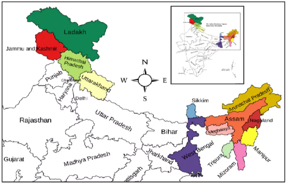
Jammu and Kashmir, Ladakh, Uttarakhand, Himachal Pradesh, Arunachal Pradesh, Manipur, Meghalaya, Mizoram, Nagaland, Sikkim, Tripura, Assam, and West Bengal
    • It stretches over 2,500 km in length and covers about 16% of India’s geographical area
  • Population and Diversity: Home to nearly 50 million people.
    • Inhabited by diverse ethnic communities such as Ladakhis, Bhutias of Sikkim, Tibetan Buddhists, and Gaddis of Himachal Pradesh, each with unique cultures, languages, and traditions.
    • Known for pluralistic demographic, economic, environmental, social, and political systems.

Significance of the Indian Himalayan Region (IHR)

  • Ecological Significance: It is a global biodiversity hotspot, home to rare flora and fauna such as the snow leopard, red panda, Himalayan monal, and medicinal plants like Yarsagumba
    • It regulates the Indian subcontinent’s climate, acts as a barrier to cold Central Asian winds, and influences monsoon patterns.
  • Hydrological Importance: Known as India’s “water tower”, it is the source of major perennial rivers — Indus, Ganga, Yamuna, and Brahmaputra — sustaining nearly 500 million people downstream and supporting agriculture, drinking water, and energy needs.
  • Economic Role: The region is rich in hydropower potential, horticulture (apples, saffron, spices), tourism, and pilgrimage-based economies
    • It provides livelihoods through forestry, traditional crafts, and adventure sports like trekking, skiing, and mountaineering.
  • Cultural Importance: The IHR hosts significant pilgrimage sitesAmarnath, Vaishno Devi, Kedarnath, Badrinath, Gangotri, and Manimahesh — reflecting deep spiritual and cultural ties
    • It is home to diverse communities such as Ladakhis, Bhutias, Tibetan Buddhists, and Gaddis, showcasing India’s pluralism and heritage.
  • Strategic Importance: Serving as India’s northern frontier, the IHR shares borders with China, Nepal, Bhutan, and Pakistan, making it vital for national security and border management
    • Areas like Ladakh and Arunachal Pradesh are crucial for India’s defence and geopolitical interests.

Himalayan Disaster Risk: Causes and Profile
Natural Causes Human-Induced Causes Institutional & Social Gaps
  • Geological Fragility: Young fold mountains, unstable slopes, active fault lines (e.g., Dhaulagiri, Indus–Ganga). 
    • Geological Survey of India (GSI, 2023): 70% of India’s landslides occur in the Himalayas.
  • Unplanned Development: Road widening, hydropower tunnelling, unchecked tourism, urbanisation in fragile zones.
  • Weak Early Warning Systems: Patchy real-time monitoring, delayed alerts (e.g., Uttarakhand 2025 floods).
  • Seismic Activity: Seismic Zones IV & V are highly prone to earthquakes, triggering landslides and avalanches.
  • Deforestation and Mining: Reduced slope stability, soil erosion, and blocked drainage channels.
  • Governance Complexity: Multi-agency overlap (district, state, and central levels) slows coordination and response.
  • Hydro-Meteorological Hazards: Cloudbursts, flash floods, and Glacial Lake Outburst Floods (GLOFs)
    • National Remote Sensing Centre (NRSC, 2022): 329 potentially dangerous glacial lakes mapped.
  • Encroachment in Riverbeds and Floodplains: Increases vulnerability (e.g., Dharali flood 2025).
  • Healthcare and Resource Gaps: Remote, marginalised communities lack medical infrastructure and resilience capacity.
  • Climate Change Multiplier: Warming at twice the global average, glacial retreat, unstable lakes, and erratic monsoon rainfall
    • India Meteorological Department (IMD, 2023): 200% rise in cloudburst incidents in Uttarakhand since 2010 (e.g., Dehradun 2025 record rainfall).
  • Pilgrimage Pressure: Overcrowding on vulnerable routes (Char Dham, Gangotri).
  • Low Public Awareness: Citizens often ignore alerts; mock drills remain tokenistic.

Systemic Shortcomings in Himalayan Disaster Preparedness and Recovery

  • Predictive Surveillance Gaps: Glacial lakes, slope instability, and debris flows are not continuously monitored by the National Remote Sensing Centre (NRSC) or Geological Survey of India (GSI) at scale. 
    • Comptroller and Auditor General (CAG, 2023) flagged underutilisation of satellite-based risk mapping.
  • Limited Citizen Preparedness: Despite over 1 crore Short Message Service (SMS) alerts during the 2025 monsoon, awareness of evacuation routes, relief shelters, and Standard Operating Procedures (SOPs) remains poor, particularly along pilgrimage corridors such as Gangotri.
  • Unchecked Development: Construction in riverbeds, slope destabilisation from road projects, and disregard of seismic codes exacerbate disaster risks. 
    • Recent Uttarakhand and Himachal Pradesh floods revealed the collapse of several structures built on fragile slopes.
  • Post-Disaster Recovery Challenges: Reconstruction of roads and bridges often overlooks slope stabilisation, while delays in compensation hinder timely rehabilitation of affected communities.

Key Government Initiatives to Mitigate Disaster Risks in the Indian Himalayan Region (IHR)

  • National-Level Frameworks:
    • The National Disaster Management Plan (NDMP, 2019) provides a comprehensive framework for disaster preparedness, mitigation, response, and recovery, with a special focus on mountain ecosystems.
    • The National Landslide Risk Mitigation Project (NLRMP) is dedicated to hazard zonation mapping, slope stabilisation, and installation of early warning mechanisms in vulnerable Himalayan slopes.
    • The National Disaster Management Authority (NDMA) has issued Guidelines and a Standard Operating Procedure (SOP) for Glacial Lake Outburst Floods (GLOFs), covering pre-disaster preparedness, real-time response, and post-disaster recovery measures.
  • Community-Centric Initiatives:
    • The Aapda Mitra Scheme builds local volunteer capacity by training citizens in disaster-prone districts to act as first responders.
    • The National Mission on Himalayan Studies (2015) under the Ministry of Environment, Forest and Climate Change (MoEFCC) supports sustainable resource management, eco-preneurship, and community-led resilience building.
    • Civil society organisations, such as the Himalayan Environmental Studies and Conservation Organization, funded by the Department of Science and Technology (DST), promote awareness campaigns, livelihood diversification, and ecosystem restoration efforts.
  • Scientific Research and Glacier Monitoring:
    • Several research programmes are supported by the Ministry of Earth Sciences (MoES), Department of Science and Technology (DST), MoEFCC, Ministry of Mines (MoM), and Ministry of Jal Shakti (MoJS) to study Himalayan glaciers.
      • Glacier Retreat Trends:
        • Hindu Kush Himalaya: Mean retreat rate of 14.9 ± 15.1 metres/year.
        • Indus Basin: Retreat rate of 12.7 metres/year.
        • Ganga Basin: Retreat rate of 15.5 metres/year.
        • Brahmaputra Basin: Retreat rate of 20.2 metres/year.
      • Cumulative Mass Loss: Between 1975 and 2023, glaciers in the Indian Himalaya lost −26 metres water equivalent (w.e.) of mass.
      • Karakoram Anomaly: Unlike other regions, the Karakoram glaciers show negligible retreat at −1.37 ± 22.8 metres/year.
  • Field-Based Monitoring and Infrastructure:
    • The National Centre for Polar and Ocean Research (NCPOR) has been monitoring six glaciers in the Chandra basin (Western Himalaya) since 2013.
    • The advanced research station ‘Himansh’, operational since 2016 in the Chandra basin, facilitates long-term field experiments and expeditions.
  • Institutional Mechanisms for Coordination:
    • A Steering Committee on Monitoring of Glaciers was established in 2023 by the Ministry of Jal Shakti (MoJS) to coordinate glacier studies across ministries and research organisations.
    • A Centre for Cryosphere and Climate Change Studies (C4S) was set up at the National Institute of Hydrology (NIH), Roorkee (2023) to conduct integrated research on climate change and water resources in the IHR.

Associated Global Initiatives

  • Sendai Framework for Disaster Risk Reduction (2015–2030): Calls for risk assessment, resilience building, and early warning.
  • Paris Agreement (2015): Encourages adaptation and resilience against climate-driven disasters.
  • Coalition for Disaster Resilient Infrastructure (CDRI, 2019): India-led global partnership for climate- and disaster-resilient infrastructure.
  • United Nations Platform for Space-based Information for Disaster Management and Emergency Response (UN-SPIDER): Provides space-based information for disaster management and emergency response.

Other Programs Supporting Himalayan Resilience

  • National Mission for Sustaining the Himalayan Ecosystem (NMSHE): Launched under the National Action Plan on Climate Change (NAPCC), the mission focuses on safeguarding glaciers, biodiversity, and traditional knowledge systems
    • It funds research on ecosystem services, climate vulnerability, and adaptive practices specific to the Himalayan states.
  • Indian Himalayas Climate Adaptation Programme (IHCAP): A collaborative initiative between India and Switzerland, IHCAP supports capacity building, climate vulnerability assessment, and science-based policy integration in Himalayan states. 
    • It emphasises community-centric adaptation and knowledge exchange on glacier monitoring and disaster preparedness.
  • SECURE Himalaya Project: Implemented by the Ministry of Environment, Forest and Climate Change (MoEFCC) with support from the United Nations Development Programme (UNDP) and Global Environment Facility (GEF), this project promotes sustainable management of alpine pastures, biodiversity conservation, and livelihood diversification
    • It links ecosystem protection with resilience-building for Himalayan communities.
  • Integrated Himalayan Development Program (IHDP): This initiative emphasises holistic development in the IHR, integrating infrastructure creation, ecological balance, and livelihood security
    • It aligns disaster risk reduction with long-term sustainable development goals.
  • National Action Plan on Climate Change (NAPCC): The broader NAPCC provides the strategic umbrella framework under which missions like NMSHE and state-level action plans function. 
    • It aims to mainstream climate adaptation and disaster risk reduction into governance, with the Himalaya recognised as an ecologically fragile and priority zone.

Way Forward

  • Massive Technology Scale-Up:
    • Geographic Information System (GIS)-based Risk Mapping: Mandatory integration of landslide, flood, and glacial risk into district-level planning.
    • Artificial Intelligence (AI)-driven Forecasting: Use of AI models trained on local hydro-meteorological data for better prediction of flash floods and cloudbursts.
    • 24×7 Remote Monitoring: NRSC to continuously track glacial lakes, snowmelt, and debris flows; drones for real-time slope surveillance.
    • Dense Doppler Radar Network: Expansion across Himalayan valleys to improve lead time for warnings.
    • The Geological Survey of India (GSI) must expand landslide mapping based on soil soaking and slope gradient.
  • Institutional and Governance Strengthening:
    • Professional Disaster Cadre: Establishment of a technically trained workforce for specialised disaster management at state and district levels.
    • Integration of Civil Society: Embedding Non-Governmental Organisations (NGOs), panchayats, and Resident Welfare Associations (RWAs) in disaster management plans.
    • Enforcement of No-Build Zones: Strict adherence to seismic codes, slope-sensitive engineering, and prohibition of construction in riverbeds.
  • Community-Centric Preparedness:
    • Expansion of Aapda Mitra: Wider reach of volunteer training programmes into schools, colleges, and local bodies.
    • Mandatory Mock Drills: Regular drills in pilgrimage towns and high-risk valleys to strengthen preparedness culture.
    • Citizen Literacy: Disaster preparedness campaigns to be treated as civic responsibility, on par with voting or paying taxes.
  • Resilient Recovery and Reconstruction:
    • Build Back Better: Roads reconstructed with slope stabilisation, river embankments reinforced, and illegal mining curbed.
    • Sustainable Infrastructure: Use of green technologies and slope-sensitive construction practices encouraged for development.
    • Pilgrimage Corridor Safety: Seasonal regulation of pilgrim footfall and use of drones, sensors, and satellite monitoring for safety.

Conclusion

  • Resilience must be the cornerstone of Himalayan development. As the Sendai Framework reminds us, “Disasters are not natural, they are the consequence of risk built into society.” Building a technology-driven, community-participatory framework aligns with Sustainable Development Goal (SDG)-11 and SDG-13.
Read More About: UN Urges to Save Glaciers, Secure The Planet Read More About: Indian Himalayan Region Needs Its Own Environmental Impact Assessment

Need help preparing for UPSC or State PSCs?

Connect with our experts to get free counselling & start preparing

Aiming for UPSC?

Download Our App

      
Quick Revise Now !
AVAILABLE FOR DOWNLOAD SOON
UDAAN PRELIMS WALLAH
Comprehensive coverage with a concise format
Integration of PYQ within the booklet
Designed as per recent trends of Prelims questions
हिंदी में भी उपलब्ध
Quick Revise Now !
UDAAN PRELIMS WALLAH
Comprehensive coverage with a concise format
Integration of PYQ within the booklet
Designed as per recent trends of Prelims questions
हिंदी में भी उपलब्ध

<div class="new-fform">


    </div>

    Subscribe our Newsletter
    Sign up now for our exclusive newsletter and be the first to know about our latest Initiatives, Quality Content, and much more.
    *Promise! We won't spam you.
    Yes! I want to Subscribe.