The Equatorial Pacific Ocean is showing early signs of a possible return of El Niño conditions, which could begin in the second half of 2026 and peak during the northern hemisphere winter.
About El Niño
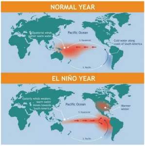
- Definition: El Niño represents the warm phase of the El Niño–Southern Oscillation (ENSO).
- El Niño is a loose translation of “little boy” or even “Christ child” in Spanish.
- Key Characteristics: It is marked by abnormally warm sea surface temperatures in the central and eastern equatorial Pacific.
- There is suppression of nutrient-rich cold water upwelling off the coasts of Peru and Ecuador.
- Trade winds weaken during El Niño conditions.
- El Niño is often associated with a weaker Indian monsoon.
- Atmospheric Mechanism During El Niño: During El Niño, atmospheric pressure over the tropical Pacific becomes lower than normal.
- Rising air over the eastern Pacific leads to increased rainfall and storm activity.
- The western Pacific experiences sinking air, higher pressure, and more stable weather conditions.
- Impact on Global Climate: These pressures and rainfall changes propagate worldwide.
- They influence weather patterns far beyond the Pacific, including South Asia.
About El Niño–Southern Oscillation (ENSO)
- ENSO is a naturally occurring climate phenomenon involving periodic fluctuations in sea surface temperatures and atmospheric pressure over the equatorial Pacific Ocean.
- Phases of ENSO: It presents 3 phases: El Niño, La Niña and a neutral phase.
- La Niña (Cool phase): Abnormally cool sea surface temperatures in the central/eastern equatorial Pacific; strengthens trade winds; often linked to stronger Indian monsoon.
- Neutral (Normal phase): Near-average sea surface temperatures.
Current ENSO Conditions
- Status of La Niña: Weak La Niña conditions, characterised by colder-than-normal sea surface temperatures in the equatorial Pacific, are currently present.
- These conditions peaked in November and are expected to weaken further during the northern hemisphere winter.
- Signs of Transition: ENSO temperature anomalies have started rising, signalling the beginning of the end of the La Niña phase.
Indicators of a Potential El Niño
- Sea Surface Temperature (SST) Anomalies: NOAA’s (National Oceanic and Atmospheric Administration) sea surface temperature anomaly data shows early signs of warming in the equatorial Pacific, contributing to the weakening of existing La Niña conditions.
- Subsurface Ocean Heat Content: Subsurface temperature anomalies show a large warm pool in the western Pacific.
- The warm pool is located at depths of about 100–250 metres.
- These warm anomalies are expanding below the ocean surface.
- This subsurface warming is weakening La Niña from the western Pacific side.
- Forecasts by Severe Weather Europe: Latest forecast data indicates El Niño could return in 2026, strengthening during the second half of the year.
- ECMWF (European Centre for Medium-Range Weather Forecasts) Seasonal Forecast: The ECMWF seasonal forecast shows ENSO conditions entering the El Niño range by summer 2026.
The forecast currently suggests a moderate-strength event, though such events often intensify beyond initial projections.
Possible Climate Impacts
- Temperature Close to Threshold: A renewed El Niño could push global temperatures closer to or above the 1.5°C threshold.
- Scientists warn of heightened risks of more frequent and intense heatwaves, droughts, wildfires, and extreme weather events.
- Impact on India: Several past monsoon droughts in India have been linked to El Niño conditions in the equatorial Pacific.
- During El Niño events, altered pressure patterns often suppress monsoon rainfall over India.
Conclusion
The early emergence of El Niño signals highlights the potential for continued global temperature stress in the coming years. Close monitoring of oceanic and atmospheric indicators remains crucial for anticipating climate risks.


 20 Dec 2025


.png)


 Current Affairs


 GS Foundation
 Optional Course
 Combo Courses
 Degree Program