Two community-based Himalayan organizations have called for immediate action to mitigate disaster risks in the Teesta Valley following the catastrophic glacial lake outburst flood (GLOF) of October 2023.
Impact of 2023 GLOF
- Casualties and Destruction: The 2023 GLOF and the subsequent NHPC, Ltd. power project dam breach claimed more than a hundred lives, disrupted livelihoods, and destroyed assets and critical military installations, apart from ecological devastation in its wake across Sikkim and West Bengal
Enroll now for UPSC Online Course
About Glacial Lake Outburst Floods (GLOFs)
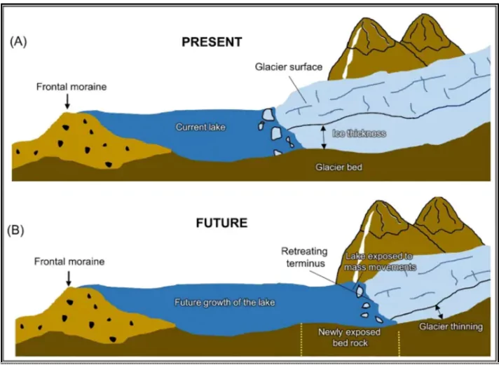
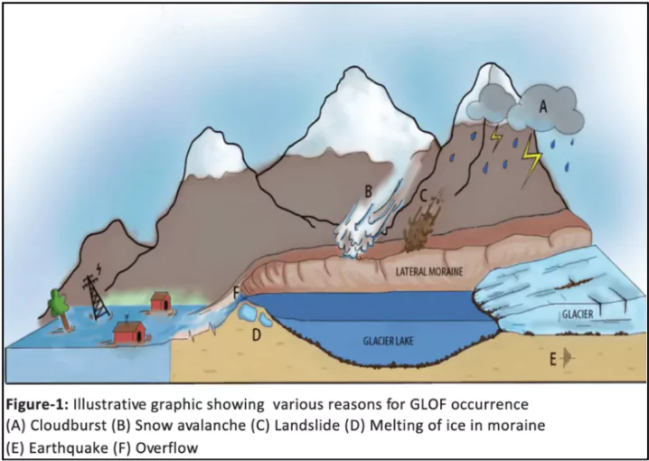
Glacial Lake Outburst Floods (GLOFs) refer to the sudden release of water and sediment from glacial lakes that are naturally dammed by barriers such as moraines (debris of ice, sand, and pebbles) or glacier ice.

Formation and Triggering Mechanism
- Glacial Lake Formation: As glaciers melt, water accumulates behind loose, naturally formed dams made of ice, sand, and other debris (moraine dams).
- These dams are inherently weak and prone to failure.
- Dam Failure: Moraine dams, made of loose debris, are unstable and susceptible to abrupt failure which leads to sudden and massive release of water from the glacial lake.
- Triggering Events: Initiated by external events such as ice or rockfalls, earthquakes, or heavy rainfall, which weaken or break the natural dams.
 Rising Global Temperatures: Warmer temperatures accelerate glacier melting and weaken sediment and ice barriers, increasing the likelihood of dam failures.
- Dam Erosion and Pressure: Natural dams fail due to erosion caused by rising water levels, a buildup of water pressure, or landslides into the lake.
Key Characteristics
- Type of Flood: Sudden, high-energy flood involving large volumes of water and sediment.
- Impact: Catastrophic downstream effects, including loss of lives, damage to infrastructure, and environmental devastation.
Proposed Solutions for Disaster Mitigation in the Region
| Category |
Measure |
Details |
| Structural Measures |
Engineering Solutions
|
- Re-channelize the Teesta River
- Use NHPC’s expertise
|
- Mitigate overflow risks and prevent urban and infrastructure damage.
- Deepen and redirect the river to safer channels.
|
| Infrastructure Repair |
- Strengthen damaged roads and bridges
|
- Ensure connectivity for economic activity and disaster relief.
- Safeguard the vital roadway connecting Kalimpong and Sikkim.
|
| Relief Camp Upgrades |
- Equip evacuation centres with solar-powered backups.
|
- Maintain operational readiness during emergencies.
|
| Non-Structural Measures |
|
|
| Early Warning Systems |
- Install automated flood alert systems
- Develop backup communication channels
|
- Deliver real-time alerts through sirens and mobile networks.
- Implement ham radios and walkie-talkies for emergency communication.
|
| Joint Action and Task Force Formation |
- Establish a Sikkim-West Bengal joint committee for coordinated disaster management.
|
- Form a task force of experts in geo-hydrology, engineering, sociology, and environmental science to develop a comprehensive action plan.
|
| Community Awareness |
- Conduct risk management and disaster preparedness campaigns
|
- Build resilience and improve community response during disasters.
|
Long-Term Strategies
- Land Use and Zoning: Identify and designate high-risk zones for potential evacuation and resettlement.
- Provide adequate compensation and support for relocated communities.
- Ecosystem Restoration: Launch afforestation programs to control soil erosion and regulate river flow.
- Tourism Revival: Ensure stable infrastructure to boost tourist traffic in the Sikkim-Darjeeling Himalayas.
Check Out UPSC Modules From PW Store
About Teesta River

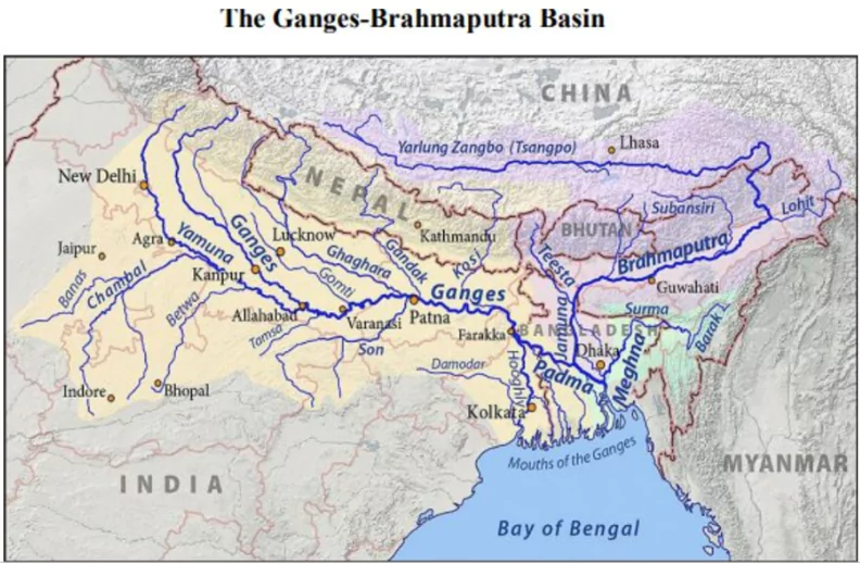
- Origin: Begins in the Himalayas near Chungthang, Sikkim.
- Path in India: Flows southward, carving a deep gorge through the Siwalik Hills east of Darjeeling, West Bengal.
- Passes through the Sivok Khola pass onto the plains of West Bengal.
- Path in Bangladesh:
- Enters Bangladesh and flows southeastward.
- Joins the Jamuna River (the Brahmaputra’s name in Bangladesh).
- Original Path: Previously flowed directly south into the Padma River (the main channel of the Ganga in Bangladesh).
- Course Alteration: Around 1787, the Teesta changed its course, flowing eastward to join the Jamuna.
- River Basin Distribution:
- India: 83% of the catchment area lies in India.
- Bangladesh: 17% of the catchment area is in Bangladesh.
- Major Barrages:
-
- Gajoldoba Barrage: Located in West Bengal, India.
- Duani Barrage: Situated in Bangladesh.
- Regional Importance: The Teesta River plays a critical role in irrigation, hydroelectric power generation, and sustaining the livelihoods of communities in both India and Bangladesh.
![]() 20 Nov 2024
20 Nov 2024


 Rising Global Temperatures: Warmer temperatures accelerate glacier melting and weaken sediment and ice barriers, increasing the likelihood of dam failures.