On July 10, 2025, a 4.4 magnitude earthquake with a shallow epicenter near Delhi exposed the city’s deep infrastructural vulnerabilities.
This event, although causing no major damage, highlights the broader risk India faces due to its seismic geography and inadequate preparedness.
- In February 2025, the Union Minister of Science and Technology and Minister of Earth Sciences outlined India’s evolving disaster management strategy, emphasizing technological advancement, institutional reforms, and public awareness to mitigate earthquake risks, particularly in high-risk zones like Gujarat, Uttarakhand, and the Himalayan belt.
Key Highlights of India’s evolving Disaster Management Strategy
- Institutional Reforms & Initiatives
- Gujarat was the first to establish a Disaster Management Committee post-2001 quake under then CM Narendra Modi, inspiring the formation of the National Disaster Management Authority (NDMA) in 2005.
- Establishment of the Institute of Seismological Research in Gujarat and later the National Centre of Seismology at the national level.
- Scientific & Monitoring Advancements
- Seismic observatories increased from 80 (2014) to 168 (2024)—doubling in a decade.
- Continuous expansion of monitoring in the Northeast, with observatories now detecting quakes above magnitude 3.0.
- Infrastructure Retrofitting & Code Compliance
- Focus on retrofitting critical infrastructure like AIIMS Delhi and Bhuj Hospital, Gujarat.
- Strict enforcement of Indian Standards (IS) seismic building codes, with efforts to retrofit schools and public buildings.
- Nationwide retrofitting plan aligned with Vision 2047 for an earthquake-resilient India.
- Public Awareness & Community Preparedness
- Regular mock drills, public campaigns (e.g., ‘Aapda Ka Samna’ on Doordarshan), and dissemination of simplified Homeowner’s Earthquake Safety Guide.
- In 2021, simplified guidelines under the Building Code of India were issued for structural safety.
- Himalayan Belt & Early Warning Systems
- Deployment of early warning systems and well-defined response protocols in Uttarakhand and other Himalayan states.
- Specific focus on disaster education, preparedness, and real-time alerts.
- Northeast Focus & Developmental Push
- Earthquake resilience in the Northeast remains a top priority.
- Launched missions like ‘Mission Mausam’, space-tech programs, and ₹1,000 crore allocation for space startups.
- Risk Transfer & Insurance Mechanisms
-
- Introduction of a ‘Risk Transfer Mechanism’ for infrastructure insurance against seismic damage.
- Comprehensive protocols now in place for damage assessment and insurance provision.
|
About Earthquake Resilience
- Refers: The ability of people, infrastructure, and systems to withstand, adapt to, and recover from earthquakes with minimal disruption. It goes beyond preventing collapse — it ensures quick recovery and sustained functionality.
| Component |
Key Focus |
Core Actions |
| Withstanding (Robustness) |
|
- Earthquake-resistant design
- Ductile materials (steel, reinforced concrete)
- Technologies: base isolation, dampers, bracing
|
| Adapting (Adaptive Capacity) |
|
- Update building codes
- Retrofit old buildings
- Risk zonation & hazard mapping
- Smart urban planning
|
| Recovering (Rapidity & Resourcefulness) |
|
- Emergency plans & drills
- Resilient power/water/transport
- Public awareness
- Economic rehab & “Build Back Better
|
About Earthquake
- Refers: An earthquake is a sudden release of energy in the Earth’s crust that creates seismic waves.
- Key Terminology:
- Focus: Also known as the hypocentre, is the point within the Earth where an earthquake originates.
- Epicenter: The point on the Earth’s surface directly above the focus or source of an earthquake.
- Fault: A fracture in the Earth’s crust where two tectonic plates meet.
- Foreshocks: Smaller earthquakes that occur before the main earthquake in the same place.
- Aftershocks: Smaller earthquakes that occur after a larger earthquake, as the Earth adjusts to the sudden movement.
- Seismograph: An instrument that measures and records ground motion caused by earthquakes.
- Seismology: The scientific study of earthquakes.
- Seismic waves: The waves of energy that travel through the Earth’s crust and cause ground shaking during an earthquake.
Diverse Causes of Earthquakes
- Plate Tectonics: The movement of the Earth’s tectonic plates can cause earthquakes when the plates interact along plate boundaries.
- Example: The 2023 Turkey-Syria earthquake, caused by the East Anatolian Fault moving between the Anatolian and Arabian plates.
- Volcanic Activity: Earthquakes can occur when magma moves beneath a volcano, causing the ground to shake.
- Example: Ongoing seismic swarms and ground deformation at Mount Rainier in 2024-2025, indicating subsurface magma movement, though not erupting, regularly cause minor tremors.
- Human Activity: Human activities, such as the injection of fluid into the ground for waste disposal, or the extraction of oil and gas from underground reservoirs, can induce earthquakes.
- Example: Persistent seismic activity in West Texas (e.g., around the Midland Basin) throughout 2023-2025, linked to wastewater injection from oil and gas operations.
- Reservoir-induced Earthquakes: The filling or emptying of large reservoirs, such as lakes or dams, can cause earthquakes as the weight of the water changes and affects the Earth’s crust.
- Example: Seismic events observed near the Three Gorges Dam in China in the early 2020s, which continue to be monitored for potential links to water level fluctuations.
- Glacial Rebound: The movement of glaciers can cause earthquakes as they advance or retreat and cause changes in the Earth’s crust.
- Example: The devastating South Lhonak Glacial Lake Outburst Flood (GLOF) in Sikkim in October 2023.
Measuring Earthquakes: Understanding Magnitude and Intensity Scales
- Measurement of Earthquakes: The magnitude and intensity of an earthquake are two ways to measure its size and impact.
- Magnitude: The magnitude of an earthquake is a measure of its energy release, and is determined from measurements of the seismic waves generated by the earthquake.
- The most commonly used scale for measuring earthquake magnitude is the Richter scale, which was developed in the 1930s.
- The Richter scale ranges from 0 to 9, with each increase in magnitude representing a tenfold increase in energy release.
- Intensity: The intensity of an earthquake is a measure of its impact at a specific location, and is determined by the effects of the seismic waves on the ground, buildings, and people.
- The most commonly used scale for measuring earthquake intensity is the Modified Mercalli Intensity (MMI) scale, which ranges from I to XII.
- The MMI scale takes into account factors such as the type of building construction, the height of the building, and the distance from the earthquake’s epicenter.
Seismic Vulnerability in India
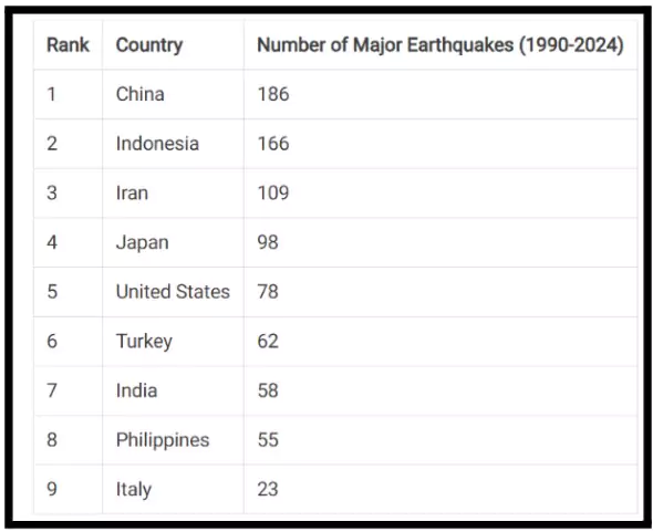
- Ranking as the seventh most earthquake-prone country in the world, India has endured 58 significant earthquakes throughout its history and is vulnerable to seismic activity.
- Geological Instability: Situated at the convergence of major lithospheric plates, India lies at the epicentre of one of the world’s most seismically volatile zones.
- Himalayan Threat: The Indian Plate’s steady 4–5 cm/year northward push against the Eurasian Plate drives India’s seismic risk, forming the Himalayas—an active zone long overdue for a catastrophic quake exceeding magnitude 8.
- Such an event could affect over 300 million people across northern India, Nepal, and Bhutan, triggering devastating socio-economic consequences far beyond initial loss of life.
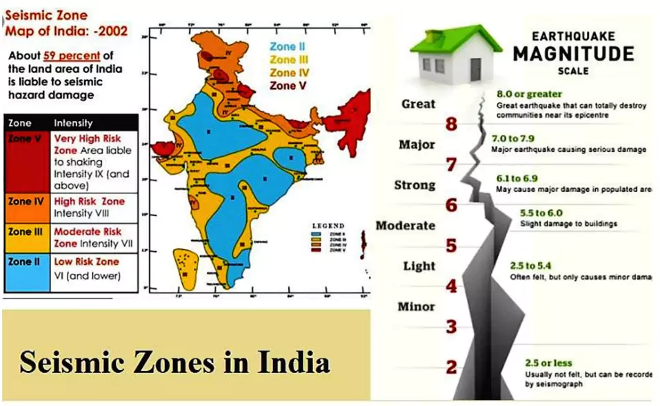
- Pan-Indian Vulnerability: Approximately 59% of India is vulnerable to earthquakes, and the Bureau of Indian Standards (BIS) has classified the country into four seismic zones based on earthquake risk, ranging from Zone II to Zone V.
- Zone V is the most active, including regions like the Himalayas, while Zone II is the least affected. Over the years, India has experienced several devastating earthquakes.
- Example: The 5.7 magnitude Tibetan quake in May 2025 caused tremors in Sikkim, reinforcing the inherent restlessness of the entire Himalayan belt.
- Northeast India (Zone V), including Manipur, Nagaland, and Mizoram, faces frequent seismic shocks—most recently seen in the 7.7 magnitude Mandalay quake of March 2025.
- The Andaman and Nicobar Islands (Zone V) remain highly susceptible to tsunamis triggered by subduction zone activity, as tragically demonstrated in 2004.
About Bureau of Indian Standards (BIS)
- The National Standard Body of India established under the BIS Act 2016 for the harmonious development of the activities of standardization, marking and quality certification of goods.
- The Act has enabling provisions for the Government to bring under compulsory certification regime any goods or article of any scheduled industry, process, system or service which it considers necessary:
- In the public interest or for the protection of human, animal or plant health,
- Safety of the environment
- Prevention of unfair trade practices, or national security
- For making hallmarking of the precious metal articles mandatory.
|
- Historical Failures in Earthquake Resilience: The 2001 Bhuj (7.7) and 2015 Nepal (7.8) earthquakes, causing ~20,000 and ~9,000 deaths respectively, underscore how inadequate preparedness leads to mass casualties, infrastructure collapse, and prolonged socio-economic disruption.
- Global Tectonic Interconnectedness: A recent surge in global seismic activity, including quakes in Greece, Indonesia, Chile-Argentina, and Ecuador since March 2025, signals dynamic planetary tectonics.
- While not directly triggering Indian quakes, these events serve as a global reminder of the imperative for heightened vigilance and preparedness, particularly with the looming threat of the “Himalayan seismic gap.”
India’s Earthquake Preparedness
- Key Government Agencies
- The National Disaster Management Authority (NDMA) has issued hazard-specific guidelines for Earthquake Risk Mitigation.
- Guidelines on Risk Mitigation: NDMA has formulated practical guides for safer construction and informed ownership.
- Homeowner’s Guide (2019): Helps citizens ensure earthquake and cyclone resilience while building or buying homes by following safety norms in masonry and Reinforced Cement Concrete (RCC) structures.
- Simplified Earthquake Safety Guidelines (2021): Based on NBC 2016, these assist people buying or constructing houses, especially in urban multi-storey buildings.
- The Model Building Bye-laws 2016 and NBC 2016 (National Building Code) include mandatory seismic safety provisions, but enforcement remains a challenge.
- The National Center for Seismology (NCS) is the nodal agency of the Government of India for monitoring earthquake activity in the country.
- The Indian National Centre for Seismology (INCOIS) and India Meteorological Department (IMD) operate an advanced seismic monitoring network using a combination of seismometers, satellites, and ground sensors.
- The National Disaster Response Force (NDRF) regularly conducts mock exercises and earthquake response drills in high-risk urban areas and hilly regions.
- Policy Measures:
- India’s National Disaster Management Plan (NDMP) includes a dedicated section on earthquake preparedness, retrofitting, and response mechanisms, revised in 2019.
- The BhooKamp app was launched for real-time earthquake updates.
- National Earthquake Risk Mitigation Project (NERMP) aims to enhance earthquake-resistant construction, capacity building, and public awareness in high-risk states.
- Under the Common Alerting Protocol (CAP), earthquake-related alerts are now geo-targeted and multilingual, accessible via SMS, mobile apps, TV, sirens, etc.
- Earthquake Disaster Risk Index (EDRI) aims to assess and map urban earthquake risk using parameters like hazard, vulnerability, and exposure.
- Others:
-
- Several State Disaster Management Authorities (SDMAs) have initiated school safety programs, mock drills, and retrofitting of lifeline buildings like hospitals and schools in seismic zones.
- The National Institute of Disaster Management (NIDM) conducts training programs on earthquake resilience for engineers, architects, and planners.
- INSAT and Doppler Weather Radar (DWR) technologies also help monitor earthquake-linked landslide or flood risks in fragile zones like the Himalayas.
- India is promoting international collaboration in earthquake research and forecasting through BIMSTEC, SCO, and Japan.
Smritivan Memorial, Bhuj: Honouring Resilience
- The Smritivan Earthquake Memorial and Museum in Bhuj, Gujarat, commemorates victims of the 2001 Gujarat earthquake (magnitude 7.9), which killed nearly 13,000 and impacted 15 lakh in Kutch.
- Inaugurated in August 2022, Smritivan blends memorialisation, disaster education, and sustainability. It spans 470 acres on Bhujiyo Dungar, featuring:
- A 1.1 MW solar plant
- 50 check-dams engraved with victims’ names
- The world’s largest Miyawaki forest (3 lakh+ plants)
- The museum has 7 thematic blocks—Rebirth, Rediscover, Restore, Rebuild, Rethink, Relive (with a 5D simulator), and Renew.
- Shortlisted for the Prix Versailles 2024 by UNESCO, it is India’s first museum to receive this recognition. Smritivan exemplifies how architecture, memory, and resilience can coexist meaningfully.
|
Challenges Posed by Rising Seismic Activities in India
- Immediate Impacts and Hazards
- Structural Collapse: Non-seismic construction leads to collapse of buildings and bridges, causing mass casualties and property loss, especially in urban areas.
- Ground Deformation: Fault ruptures and intense shaking damage structures; liquefaction in saturated soils causes buildings to sink or tilt.
- Landslides & Rockfalls: Triggered in hilly terrains, they bury settlements, block roads, and isolate communities.
- Tsunamis: Underwater quakes, especially in subduction zones, cause coastal flooding and mass destruction.
- Fires & Explosions: Ruptured gas lines and electrical failures often trigger post-quake fires, hindering rescue.
- Dam Failures: Earthquakes can damage dams and reservoirs, causing catastrophic flooding downstream.
- Hazardous Leaks: Quakes can rupture industrial units, releasing toxic chemicals or pollutants.
- Service Disruption: Power cuts, water shortages, communication failures, and damaged roads cripple emergency response.
- Weak Implementation of Safety Rules
- Even though now better understand earthquakes and have early warning tools like the IndiaQuake app, there is still a big gap between knowing and actually doing.
- Building rules are often not followed, and most people are not aware of how to stay safe.
- In comparison, countries like Taiwan strictly follow safety rules, and cities like Bangkok have improved their earthquake laws to reduce damage.
- On the other hand, places like Myanmar suffered more damage because such rules were not followed.
- Social and Economic Impact
- A strong earthquake doesn’t just cause deaths and damage to buildings — it can completely disrupt daily life and the economy.
- It may lead to people losing their homes, essential services stopping (like electricity, water, and transport), and jobs being lost.
- The healthcare system may get overloaded, and mental stress will be widespread.
- Rebuilding everything will cost a lot and may slow down the growth of affected areas for many years.
- Link to Climate Change
-
- Climate change makes earthquake risks even more dangerous.
- Events like heavy rain, floods, and landslides can weaken buildings and roads, making them more likely to fail during an earthquake.
- These disasters can also delay rescue and recovery efforts.
- Together, they create a chain reaction of problems that is hard to manage.
Way Forward
1. Learning from Global Best Practices
- Taiwan: After the 1999 Chi-Chi quake, Taiwan overhauled disaster governance, enforced strict building codes, and built a real-time seismic monitoring network. Base isolation, tuned mass dampers, and public awareness ensured minimal damage during the 2024 Hualien earthquake.
- Japan: Japan enforces strict seismic codes, uses base isolation and damping systems, and builds with reinforced materials. Its early warning system provides rapid alerts, while public drills and Disaster Prevention Day ensure high community preparedness against frequent earthquakes.
- Chile: Chile’s adaptive building codes evolve after major quakes. Use of reinforced concrete shear walls is widespread. Performance-based designs ensure building functionality post-quake, while tsunami warning systems enable timely evacuations, as seen during the 2015 M8.3 earthquake.
- New Zealand: After the Canterbury quakes, New Zealand introduced life-safety-oriented codes and pioneered low-damage technologies like base isolators, and rocking walls. It follows an all-hazards approach, enhancing overall infrastructure resilience to earthquakes and other natural disasters.
2. Stronger Laws and Better Coordination
- Strict Building Rules: All new buildings, especially in high-risk areas, must follow the IS 1893:2016 seismic code. Independent inspections should be mandatory.
- Update Laws Regularly: Disaster management laws and building rules should be revised often, keeping up with new scientific knowledge.
- Better Coordination: Ministries like Earth Sciences, Housing, Urban Affairs, Transport, and state disaster bodies must work together for effective planning and action.
- Safer City Planning: Use seismic microzonation (detailed mapping of risk) in cities to avoid construction on weak or dangerous land.
3. Retrofitting and Safer Infrastructure
- Focus on Older Buildings: Launch large-scale retrofitting drives, especially in vulnerable cities like Delhi. Use methods like steel jacketing, Fiber Reinforced Polymer (FRP) wrapping, and base isolation.
- Essential Services:
- Telecom: Ensure mobile towers can survive earthquakes; map cables and set up emergency backup systems, especially in coastal areas.
- Electricity: Strengthen power plants, substations, and grids to avoid blackouts.
- Water & Sewage: Reinforce water treatment and sewage systems to avoid disease outbreaks after quakes.
- Transport: Make bridges, tunnels, and flyovers earthquake-resistant; create backup routes.
- Cost Estimate: Retrofitting may need around ₹50,000 crore annually—requiring dedicated funding and smart finance models.
4. Technology and Data Use
- More Sensors: Increase and upgrade earthquake sensors for better tracking and quicker alerts.
- Early Warning Systems: Expand ShakeMap and other alert tools to inform the public quickly.
- Use of AI & Machine Learning: Use AI for better prediction, damage forecasting, and planning.
- GIS Mapping: Use digital maps combining building, land, and population data to identify vulnerable zones and plan responses.
5. Public Participation and Awareness
- Education Campaigns: Run multi-language awareness programs on earthquake safety, emergency kits, and evacuation plans.
- Regular Practice Drills: Conduct mock drills in schools, offices, and public places to improve readiness.
- Citizen Involvement: Encourage people to report unsafe buildings and join local surveys.
- Train Local Teams: Build community disaster teams trained in first aid, rescue, and damage reporting. The Bhuj earthquake showed locals are often the first to respond.
- Traditional Wisdom: Document and promote local, time-tested earthquake-safe building styles.
Conclusion
The July 2025 Delhi tremors underscore the need for seismic resilience rooted in constitutional values of safety and dignity. Enforcing building codes, investing in resilient infrastructure, and public awareness align with SDG 11 (Sustainable Cities) and SDG 13 (Climate Action).
Read More About: Bureau of Indian Standards (BIS)


 17 Jul 2025


.png)


 Current Affairs


 GS Foundation
 Optional Course
 Combo Courses
 Degree Program