Kamchatka Peninsula: 8.8 Magnitude Quake Triggers Tsunami Alerts Across Pacific Region

PWOnlyIAS

July 30, 2025

Kamchatka Peninsula: 8.8 Magnitude Quake Triggers Tsunami Alerts Across Pacific Region

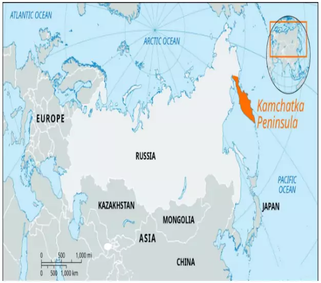
A powerful undersea earthquake on a Richter scale 8.8 magnitude quake off Russia’s Kamchatka Peninsula has triggered tsunami alerts across the Pacific region, affecting countries from Japan to the United States.

  • It is the strongest quake in the region since 1952, according to the Russian Academy of Sciences.
  • Tsunami waves hit Russia’s Kuril Islands and Japan’s Hokkaido island shortly after the earthquake.
  • Indonesia, and the Philippines issued tsunami alerts for vulnerable coastal zones.

About Kamchatka Peninsula

Kamchatka Peninsula

  • Location: Far eastern Russia
    • Between the Sea of Okhotsk (west) and Pacific Ocean & Bering Sea (east)
    • At the junction of the Pacific and North American tectonic plates 
  • Geographical Features:
    • It is about 1,200 km long north-south and about 480 km across at its widest.
    • River: Kamchatka River 
    • Highest Point: Klyuchevskaya Sopka – tallest & most active volcano
    • Climate: Tundra – cold, snowy winters; cool, wet summers
    • Environment: Harsh terrain; rich biodiversity; low population density (<1 person/sq. km)
  • Volcanic & Geothermal Activity:
    • Kamchatka PeninsulaOver 150 volcanoes, including 29 active
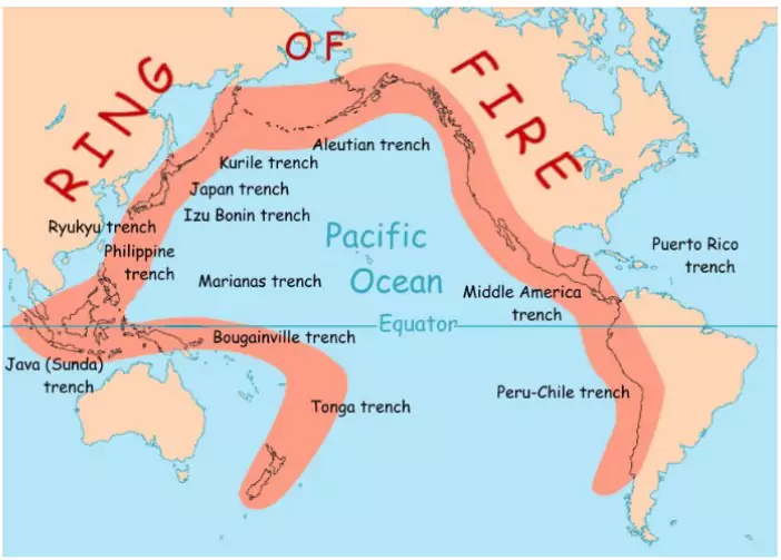
    • Part of UNESCO World Heritage SiteVolcanoes of Kamchatka
    • One of the most geothermally active regions in the world.
  • Kuril Archipelago:
    • Extends south from Kamchatka to Japan’s Hokkaido
    • Disputed territory between Russia and Japan

Kamchatka’s Seismic Vulnerability

  • Kamchatka is located on the Pacific Ring of Fire, a major seismic zone.
    • It lies at  junction of the Pacific and North American tectonic plates
  • It has a history of major quakes (e.g., 1952, 2006, 2020), many of which caused tsunamis. 

The Ring of Fire

The Ring of Fire

  • The Ring of Fire spans 40,000+ km, shaped like a horseshoe around the Pacific.
  • Includes subduction zones involving Eurasian, North American, Australian, Philippine and other plates.
  • Seismic Activity: Tectonic plates collide, slip, or subduct, causing frequent earthquakes and volcanic eruptions.
  • Geothermally active region: Rough plate edges get stuck and suddenly release, triggering quakes.

To get PDF version, Please click on "Print PDF" button.

Need help preparing for UPSC or State PSCs?

Connect with our experts to get free counselling & start preparing

Aiming for UPSC?

Download Our App

      
Quick Revise Now !
AVAILABLE FOR DOWNLOAD SOON
UDAAN PRELIMS WALLAH
Comprehensive coverage with a concise format
Integration of PYQ within the booklet
Designed as per recent trends of Prelims questions
हिंदी में भी उपलब्ध
Quick Revise Now !
UDAAN PRELIMS WALLAH
Comprehensive coverage with a concise format
Integration of PYQ within the booklet
Designed as per recent trends of Prelims questions
हिंदी में भी उपलब्ध

<div class="new-fform">


    </div>

    Subscribe our Newsletter
    Sign up now for our exclusive newsletter and be the first to know about our latest Initiatives, Quality Content, and much more.
    *Promise! We won't spam you.
    Yes! I want to Subscribe.