Brazil has declined to join China’s Belt and Road Initiative (BRI), making it the second BRICS member, after India, to opt out of the project.
About Brazil

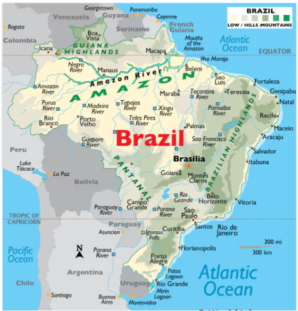
- Location & Size: Brazil is located in central-eastern South America, is the fifth largest country globally.
- It is positioned in the Northern, Southern, and Western hemispheres, crossing both the Equator and Tropic of Capricorn.
- Borders: Brazil borders every South American country except Chile and Ecuador.
- It shares boundaries with Uruguay, Argentina, Paraguay, Bolivia, Peru, Colombia, Venezuela, Guyana, Suriname, and French Guiana.
- Geography of Brazil:
- Brazilian Highlands: Occupies eastern, central, and southern areas, including Sao Paulo and Brasília.
- Amazon Rainforest: Covers nearly half of Brazil in the north, housing the Amazon River and rich biodiversity.
- Pantanal: One of the world’s largest wetlands, located in the west.
- Major Water Bodies:
- Amazon River: Second-longest river globally, flowing through the rainforest.
- Sao Francisco River: Brazil’s longest entirely domestic river, located in the northeast.
- Iguacu River: Site of the Itaipu Dam in the south.
- Highest Point: Pico da Neblina, at 2,999m (9,823ft), is Brazil’s highest peak.
- Coastline: Stretching about 7,491 km along the Atlantic Ocean, featuring islands like Fernando de Noronha and the Abrolhos Islands.
Enroll now for UPSC Online Classes
About Amazon River Basin
- Amazon River: Largest river by discharge volume of water in the world.
- Begins in the Andes Mountains and drains into the Atlantic Ocean.
- Amazon basin is Part of South America drained by the Amazon River and its tributaries.
- Located in Bolivia, Brazil, Colombia, Ecuador, Guyana, Peru, Suriname and Venezuela.
- Most of the basin is covered by the Amazon Rainforest, also known as Amazonia, the largest rainforest in the world.
- The Basin is bordered by the Brazilian Highlands on the south and the Guyana Highlands on the north.
![]() 4 Nov 2024
4 Nov 2024

