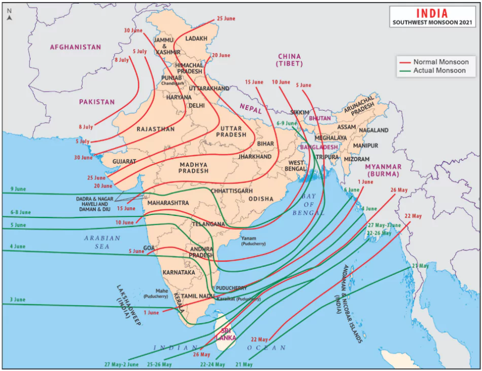
The Southwest Monsoon made its onset over Kerala on May 24, eight days ahead of its typical onset date of June 1, according to the Indian Meteorological Department (IMD).
- It last happened in 2009 that the monsoon arrived so early in the year, on May 23.
- According to the IMD forecast, the seasonal rainfall across the country as a whole is likely to be 106% of the Long Period Average (LPA), indicating a high probability of above-normal rainfall during the monsoon season.
Meaning of ‘onset of monsoon’
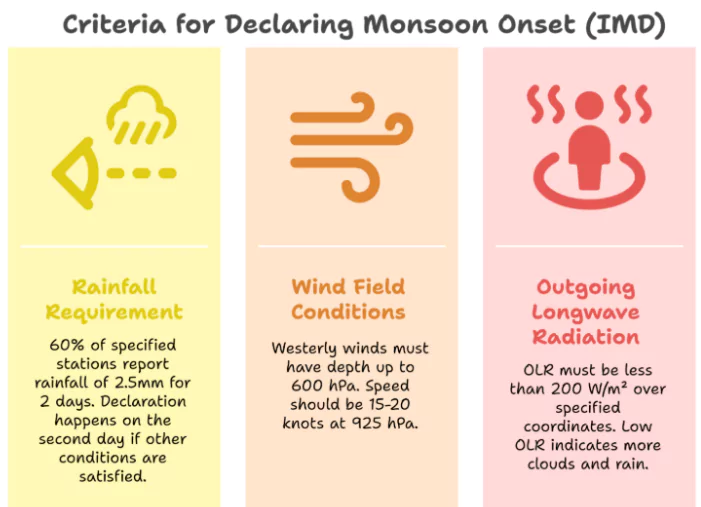
- Start of Monsoon Season: The onset of the monsoon (June-September) marks the arrival of the southwest monsoon over the Indian subcontinent.
- This occurs when the monsoon winds reach Kerala, the southernmost state of India.
- Starting months: This event usually happens around late May or early June.
- Annual Rainfall: The southwest monsoon provides over 70% of India’s annual rainfall.
- It is crucial for agriculture, water resources, and overall economic well-being.
| Northern Limit of Monsoon (NLM): An imaginary line marking the monsoon’s northernmost progress on a given day. |
Factors Affecting South-West Monsoon Formation
- Differential Heating and Cooling
- Land-Water Contrast: Variation in temperature between land and water creates low pressure over the Indian landmass and high pressure over the surrounding seas.
- Position of Inter Tropical Convergence Zone (ITCZ)
- Summer Shift: During summer, ITCZ moves over the Ganga plain. (normally positioned about 5°N of the equator).
- This zone is also called the monsoon-trough which
- It influences monsoon formation.
- High-Pressure Area over Indian Ocean
- East of Madagascar: A high-pressure area exists east of Madagascar, around 20°S in the Indian Ocean.
- The intensity and position of this area impact the Indian Monsoon.
- Tibetan Plateau Heating: The Tibetan plateau heats intensely during summer, generating strong vertical air currents and forming low pressure about 9 km above sea level.
- Influence of Jet Streams
- Westerly Jet Stream: Movement of the westerly jet stream to the north of the Himalayas influences monsoon formation.
 Tropical Easterly Jet Stream: Presence of the tropical easterly jet stream over the Indian peninsula during summer affects monsoon patterns.
- Southern Oscillation (SO)
- Pressure Reversal: Normally, high pressure occurs in the tropical eastern south Pacific Ocean and low pressure in the eastern Indian Ocean.
- However, in some years, this pattern reverses which is known as the Southern Oscillation (SO).
- Indian Ocean Dipole (IOD):
- Positive IOD: Warmer western Indian Ocean enhances rainfall.
- Negative IOD: Cooler western Indian Ocean suppresses rainfall.
- Local Factors: Urbanization and deforestation alter microclimates, impacting rainfall distribution.
Reasons of Early Onset of Monsoon in 2025
- Active Madden-Julian Oscillation (MJO): The MJO was in an active phase (Phase 4) with amplitude >1, enhancing convection over the Indian Ocean and accelerating the formation of pre-monsoon cloud bands.
- This significantly contributed to early rainfall over Kerala and western coast.
- Strong Cross-Equatorial Flow and Somali Jet: Unusually strong low-level jet streams from the southern Indian Ocean brought large volumes of moisture-laden winds into the Arabian Sea.
- This intensified the southwesterly flow and pushed the monsoon front rapidly northward.
- Pre-Monsoon Heat Low Pressure Over Arabian Sea: An early-season low-pressure system formed over Pakistan and adjoining areas.
- It acted as a suction device for moist air along the monsoon trough and triggering pre-monsoon showers across coastal and peninsular regions.
- Monsoon trough: It is an elongated low-pressure area extending from the heat low to the north Bay of Bengal.
- The north-south swinging of this trough causes rainfall during the June–September period across the core monsoon zone.
- Enhanced Mascarene High: A stronger-than-usual high-pressure system near the Mascarene Islands drove a robust southwesterly flow toward India, facilitating early monsoon onset over the southern coast.
- Increased Convection: An increase in the convective activity, that is, the vertical transport of heat and moisture in the atmosphere, also brings rainfall.
- For example, a convective system over Haryana moved southeastward recently and led to rains in the Delhi region.
- Reduced Snow Cover Over Western Himalayas: Low snow cover in March–April 2025 over Western Himalayas led to increased heating of the subcontinent.
- This enhanced land-sea thermal contrast and strengthened the low-pressure area over northwest India.
- Neutral ENSO Conditions: Neither El Niño nor La Niña was active.
- The neutral ENSO phase supported a stable and uninterrupted development of monsoon currents.
- Neutral Indian Ocean Dipole (IOD): IOD remained in the neutral phase, which did not disrupt the SST gradient in the equatorial Indian Ocean, ensuring smooth monsoon progression.
- Warmer Sea Surface Temperatures (SSTs): Above-normal SSTs in the Arabian Sea and Bay of Bengal provided additional latent heat, fuelling convection and intensifying early monsoon dynamics.
About ENSO
- ENSO (El Niño–Southern Oscillation) is a coupled ocean–atmosphere phenomenon originating in the tropical Pacific Ocean.
- It includes two key phases:
- El Niño: Abnormal warming of equatorial eastern Pacific Ocean.
- La Niña: Abnormal cooling of the same region.
About Indian Ocean Dipole (IOD)
- It is an ocean-atmosphere interaction phenomenon in the equatorial Indian Ocean, similar to ENSO but specific to the Indian Ocean basin.
- It is characterized by the difference in Sea Surface Temperatures (SSTs) between:
- Western Indian Ocean (off the coast of East Africa), and
- Southeastern Indian Ocean (near Indonesia and Sumatra).
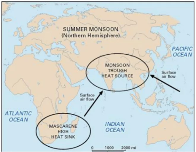
About Mascarene high
- Mascarene High is a high-pressure area that is found around Mascarene Islands (in south Indian Ocean) during monsoon period.
- This is responsible for cross equatorial flow through south Arabian Sea and it acts as southern hemispheric linkage.
About Southern Oscillation (SO)
- The Southern Oscillation (SO) is a large-scale atmospheric pressure oscillation between the eastern and western tropical Pacific Ocean.
- It reflects the seesaw pattern of air pressure:
- Between Tahiti (in the eastern Pacific) and
- Darwin (in northern Australia, western Pacific)
About Somali Jet
- The Somali Jet is a low-level jet stream — an inter-hemispheric, cross-equatorial flow of air — that forms along the east coast of Africa and reaches jet speeds (~50–60 km/h) during the Southwest Monsoon.
- Origin: Near Mauritius and the northern part of Madagascar.
- Passes through Kenya, Ethiopia, and Somalia.
- Enters Arabian Sea in May and reaches the west coast of India by June.
|
What is Madden-Julian Oscillation (MJO)?
- MJO is a tropical intra-seasonal oscillation in atmospheric pressure, wind, and convection.
- The phenomenon takes its name from the two scientists who identified it in 1971 — Roland Madden and Paul Julian, who then worked at the National Centre for Atmospheric Research in Boulder, Colorado.
- Rainfall Impact: Can lead to above-normal rainfall during its active phase. Multiple MJO events can occur in one monsoon season.
Structure of MJO
- Convective (wet) phase: Enhanced cloudiness and rainfall.
- Suppressed (dry) phase: Reduced cloud cover and rainfall.
Real-time Multivariate (RMM) Index
- MJO is divided into 8 phases, each representing a location of its convective center:
- Phases 2–3: Western Indian Ocean (affects onset)
- Phases 4–5: Eastern Indian Ocean (triggers monsoon surge)
- Phases 6–7–8: Maritime Continent to Western Pacific
|
Key Features of the Madden-Julian Oscillation (MJO)
- Nature: A coupled ocean–atmosphere phenomenon occurring in the tropical belt, influencing short-term weather and climate variability.
- Origin: Typically develops over the western Indian Ocean, near the East African coast.
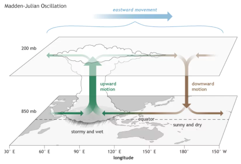 Movement: Propagates eastward across the tropics toward the central and eastern Pacific at a speed of 4–8 meters per second.
- Cycle Duration: Completes one full oscillation in 30 to 60 days, forming the basis of intra-seasonal variability.
- Geographic Scope: Most prominent between 30°N and 30°S. India, being in this band, is heavily influenced by MJO cycles.
- Main Components: Consists of alternating wet (active) and dry (suppressed) phases of convection, significantly modulating rainfall patterns.
- Observation Tool: Monitored using the RMM (Real-time Multivariate MJO) Index, which identifies the location and strength of MJO phases across 8 global zones.
MJO vs ENSO
| Parameter |
MJO |
ENSO |
| Type |
Intra-seasonal |
Inter-annual |
| Duration |
30–60 days |
6–18 months |
| Movement |
Eastward (mobile) |
Stationary (Pacific) |
| Predictability |
Short-term weather |
Seasonal climate |
| Impact |
Day-to-week rainfall |
Seasonal monsoon variability |
Role of Climate Change to Early Onset
- Faster Land Heating: Higher summer temperatures on the Indian subcontinent cause stronger and earlier formation of the low-pressure zone over northwest India.
- Enhanced land–sea thermal contrast accelerates the pull of monsoon winds.
- Reduced Himalayan Snow Cover: Studies show decreased snow accumulation in spring leads to rapid land heating, contributing to earlier low-pressure system formation.
- 2025 saw notably low snow cover, aiding early onset.
- Warmer Sea Surface Temperatures (SSTs): Climate-induced SST rise in the Arabian Sea and Bay of Bengal fuels more latent heat release, leading to stronger convection.
- Supports early cloud formation and intensifies monsoon flow.
- Altered Jet Stream and ITCZ Dynamics: Climate warming affects the Sub-Tropical Westerly Jet (STWJ), allowing northward migration of the Inter-Tropical Convergence Zone (ITCZ) earlier in the season.
- Facilitates establishment of the monsoon trough over the Indian subcontinent ahead of schedule.
- Stronger Cross-Equatorial Winds: Enhanced thermal gradients over the equator due to warming result in more robust Somali Jet and stronger moisture-laden winds arriving earlier over India.
- Changing Global Oscillations: More frequent strong MJO events have been observed due to warming oceans.
- In 2025, MJO Phase 4 with amplitude >1 triggered early convection and rainfall – a pattern increasingly linked to climate shifts.
Impact of Early Onset of Monsoon
Positive Impacts
- Early Agricultural Sowing: Facilitates timely sowing of Kharif crops (rice, pulses, cotton, etc.).
- Reduces risk of crop yield delays due to late planting.
- Boost to Groundwater Recharge: Early rains help replenish soil moisture and water tables, critical for rainfed areas.
- Aids in reducing irrigation stress in early-season crops.
- Cooling Effect on Heat Waves: Reduces duration and intensity of pre-monsoon heatwaves, improving public health outcomes and lowering electricity demand.
- Improved Hydropower and Reservoir Filling: Early runoff from rainfall supports faster filling of dams and reservoirs, helping power and irrigation management.
Negative Impacts
- Agronomic Mismatch: If early onset is not followed by sustained rainfall, initial sowing may fail.
- Leads to wasted seeds, re-sowing costs, and reduced crop productivity.
- Flood and Urban Drainage Stress: Sudden heavy rainfall over dry, unprepared soils leads to runoff and flash floods.
- Urban centres like Mumbai, Guwahati, and Bengaluru face flooding due to clogged drains.
- Forecasting and Planning Challenges: Early monsoon complicates agricultural advisories and IMD forecasts, especially if linked with a shortened or erratic monsoon season.
- Water resource departments may be caught off-guard in terms of dam release planning.
- Disruption of Traditional Climate Calendars: Indigenous and agrarian communities that rely on solar-lunar sowing cycles may find their customary practices mismatched, impacting cultural rhythms and food security.
Technologies Supporting Monsoon Forecasting
- Satellite Observations: INSAT-3D, INSAT-3DR, Megha-Tropiques – provide real-time rainfall, cloud, and wind data.
- Buoy Networks: ARGO floats, OMNI buoys, and Moored Buoy systems monitor SSTs, salinity, ocean currents in Arabian Sea and Bay of Bengal.
- Argo floats: Measure temperature and salinity.
- OMNI buoys: Providing real-time data on currents, conductivity, and temperature, as well as other parameters.
- Moored buoy systems: Used for securing vessels and providing navigation aids.
- Doppler Weather Radars (DWR): IMD operates 37+ DWRs for short-term rainfall tracking and nowcasting.
- Help detect cyclones, thunderstorms, and rainfall bands.
- Supercomputers: IMD’s Mihir (6.8 PFLOPS) and Pratyush (4 PFLOPS) enable real-time simulations of monsoon models and climate analysis.
|
Government Initiatives
- About National Monsoon Mission (NMM)
- NMM was launched by the Ministry of Earth Sciences (MoES) in 2012,
- It is a mission-mode project aimed at developing a state-of-the-art dynamical prediction system for monsoon rainfall across various time scales.
- Goal: To improve the accuracy and reliability of monsoon forecasts to benefit agriculture, water resources, and disaster management.
- About Mission Mausam:
- Mission Mausam was launched in January 2025 to upgrade India’s weather forecasting system.
- Nodal Ministry: Ministry of Earth Sciences (MoES).
- Aim: To enhance India’s ability to predict and respond to extreme weather events and the impacts of climate change.
- Farmer Support:
- Pradhan Mantri Fasal Bima Yojana (PMFBY): Crop insurance for monsoon-related losses.
- Pradhan Mantri Krishi Sinchayee Yojana (PMKSY): Enhances irrigation to reduce monsoon dependency.
- PM-KISAN: Income support for farmers.
- Disaster Management: NDMA and SDRF coordinate flood/cyclone response.
- Water Management: Jal Shakti Abhiyan and Atal Bhujal Yojana promote groundwater recharge.
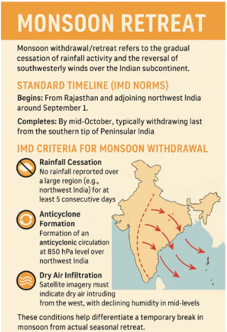
Conclusion
The early onset of the southwest monsoon in 2025, driven by climatic and oceanic factors, underscores its critical role in India’s agriculture, water resources, and economy. Government initiatives like the National Monsoon Mission and Mission Mausam, supported by advanced technologies, enhance forecasting accuracy and resilience, ensuring sustainable development and disaster preparedness.


 28 May 2025


.png)


 Current Affairs


 GS Foundation
 Optional Course
 Combo Courses
 Degree Program