Myanmar Earthquake

PWOnlyIAS

March 29, 2025

Myanmar Earthquake

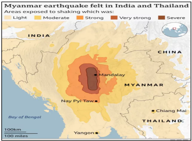
Recently, a 7.7-magnitude earthquake struck Myanmar causing severe damage in Mandalay and affecting neighboring countries.

About the Myanmar Earthquake

Myanmar Earthquake

  • The Myanmar Earthquake is  the strongest globally in two years, and was followed by multiple aftershocks.
  • Parts of Northeast India also felt tremors, but no major casualties or damage were reported.
  • The epicenter was 17.2 km from Mandalay, at a shallow depth of 10 km, intensifying the damage.
  • The shallow depth (10 km) of the recent earthquake intensified its ground shaking, leading to widespread destruction.
    • Shallower earthquakes cause greater surface damage compared to deeper ones.

Impact of the Earthquake

  • The U.S. Geological Survey (USGS) Earthquake Hazards Program estimated potential fatalities between 10,000 and 100,000.
    • Economic losses up to 70% of Myanmar’s GDP.
  • The central region of Myanmar, where the recent quake struck, is less accustomed to large earthquakes, worsening the impact.

Frequency of  Earthquakes in Myanmar

  • Myanmar has experienced at least six earthquakes above magnitude 7 since 1900.
  • Notable earthquakes:
    • 1990 (Magnitude 7.0): 32 buildings collapsed.
    • 1912 (Magnitude 7.9): Near the recent earthquake’s epicenter.
    • 2016 (Magnitude 6.9): Affected the same region.
  • Over the last 100 years, Myanmar has recorded 14 earthquakes of magnitude 6 or above.
  • The 1839 earthquake (Magnitude 8.3) was one of the most destructive, killing 300-400 people.

Earthquake due to tectonic activity

  • The Earth’s lithosphere consists of moving tectonic plates, interacting over billions of years.
  • Earthquakes occur when plates slip past each other, releasing stored seismic energy.

Factors Responsible for Frequent Earthquakes in Myanmar

  • Myanmar’s location between two tectonic plates : The location between the India and Eurasia plates places it at particular risk of earthquakes.
    • The boundary between the two plates is called the Sagaing Fault
  • Myanmar’s Sagaing Fault is a major north-south fault line, highly prone to seismic activity.
  • It marks the tectonic boundary between the Indian Plate (moving north) and the Eurasian Plate.
    • The recent earthquake was caused by strike-slip faulting, where the plates move sideways against each other.
  • Earthquakes affect regions beyond the epicenter due to seismic waves spreading along the fault line.

India’s Response to the Myanmar Earthquake

  • Operation Brahma : India delivered 15 tonnes of relief materials to Myanmar using a C-130J military transport aircraft of the Indian Air Force under operation Brahma.
  • Rescue Support: India deployed 80 National Disaster Response Force (NDRF) personnel to assist in rescue and relief operations in quake-hit areas.
  • Humanitarian Assistance: Alongside China and Russia, India extended immediate aid, reaffirming its commitment to regional disaster response and support.
Additional Reading: Earthquakes

To get PDF version, Please click on "Print PDF" button.

Need help preparing for UPSC or State PSCs?

Connect with our experts to get free counselling & start preparing

Aiming for UPSC?

Download Our App

      
Quick Revise Now !
AVAILABLE FOR DOWNLOAD SOON
UDAAN PRELIMS WALLAH
Comprehensive coverage with a concise format
Integration of PYQ within the booklet
Designed as per recent trends of Prelims questions
हिंदी में भी उपलब्ध
Quick Revise Now !
UDAAN PRELIMS WALLAH
Comprehensive coverage with a concise format
Integration of PYQ within the booklet
Designed as per recent trends of Prelims questions
हिंदी में भी उपलब्ध

<div class="new-fform">


    </div>

    Subscribe our Newsletter
    Sign up now for our exclusive newsletter and be the first to know about our latest Initiatives, Quality Content, and much more.
    *Promise! We won't spam you.
    Yes! I want to Subscribe.