PM GatiShakti launched on 13 Oct 2021 to deliver integrated, multimodal connectivity, completes four years.
About PM GatiShakti National Master Plan (PMGS-NMP)
- About: It is a digital, GIS-based platform that integrates infrastructure planning across 57 Central Ministries and 36 States/UTs.
- Developed by: BISAG-N (Bhaskaracharya National Institute for Space Applications & Geoinformatics), it enables real-time data sharing, project mapping, and multimodal connectivity.
- Objectives: To enhance ease of living, ease of doing business, minimize disruptions and expedite completion of works with cost efficiencies.
- Key Engines Driving PMGS-NMP: Seven primary engines that together propel economic growth, employment, and trade competitiveness:
- Railways: Dedicated Freight Corridors, station redevelopment, and multimodal logistics parks.
- Road Transport & Highways: Bharatmala corridors, expressways, and inter-linking of economic nodes.
- Ports & Waterways: Sagarmala, inland waterways, coastal cargo hubs, and port-rail linkages.
- Airports & Civil Aviation: UDAN regional connectivity, cargo terminals, and logistics airports.
 Mass Urban Transport: Metro, Regional Rapid Transit System, and city logistics integration for urban efficiency.
- Logistics Infrastructure: Multimodal Logistics Parks (MMLPs), Warehousing Zones, and Inland Container Depots.
- Energy Transmission & Communication (supportive engine): Power, IT, and telecom corridors ensure digital and energy connectivity.
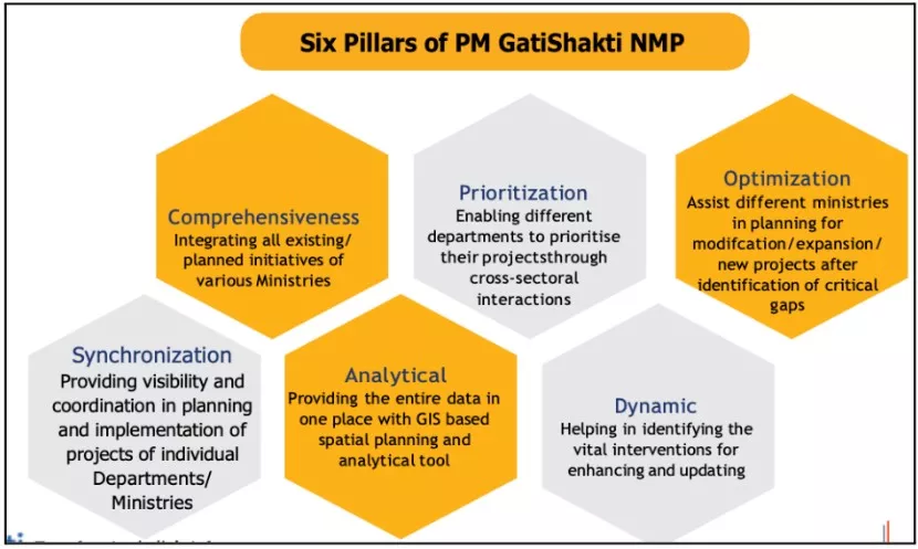
- 6 Pillars of PMGS-NMP (Refer Image)
- Features of PMGS-NMP:
- Cloud-based & Secure: Built on open-source technology and hosted on MeghRaj (Government Cloud)
 Data-Driven Decision-Making: Uses ISRO imagery, real-time satellite data, and IoT inputs to evaluate feasibility and minimize environmental and social conflicts.
- Inter-Ministerial Coordination: The Network Planning Group (NPG) ensures cross-sector synchronization and avoids redundant investments.
- Unified Logistics Interface Platform (ULIP): Integrates 33+ logistics IT systems from 10 ministries; 930+ private players onboard.
- Integration of Flagship Programs: Merges Bharatmala, Sagarmala, UDAN, Inland Waterways, Economic Corridors, and Industrial Clusters under one digital umbrella.
- District-Level Decentralisation: District Master Plan (DMP) introduced for spatially informed, local-level development planning.
Key Achievements of PM GatiShakti
Network Planning Group (NPG)
It is an inter-ministerial body under PM GatiShakti that evaluates and coordinates infrastructure projects to ensure multimodal connectivity, last-mile integration, and synchronized implementation across sectors.
- Nodal Ministry: Department for Promotion of Industry and Internal Trade (DPIIT), Ministry of Commerce & Industry
- Composition: Senior representatives from key infrastructure ministries — Railways, Road Transport & Highways, Ports & Shipping, Civil Aviation, Power, Petroleum & Natural Gas, and Telecom.
|
- Whole-of-Government onboarding & platform scale: 57 Central Ministries/Departments, 36 States/UTs onboarded; ~1,700 geospatial layers live on the National Master Plan (NMP).
- The Network Planning Group (NPG) has evaluated 293 projects worth ₹13.59 lakh crore for multimodality, last-mile and synchronized execution.
- State Master Plans (SMPs): All 36 States/UTs have aligned their State Master Plan portals with the national platform.
- A District Master Plan (DMP) earlier has been launched for 28 aspirational districts to enable area-based, geospatial planning at the local level
- District Master Plan (DMP) Expansion: The PM GatiShakti District Master Plan (PMGS-DMP) has now mapped 112 Aspirational Districts, extending spatially informed, data-driven planning to the grassroots level.
- Ports & Logistics Efficiency: According to the World Bank’s Logistics Performance Index (LPI) 2023, India ranked 22nd in International Shipments and 38th overall.
- Indian ports achieved a turnaround time of just 0.9 days, outperforming major economies such as the USA (1.5 days), Australia (1.7 days), Germany (1.3 days), and Singapore (1.0 day).
- Training & capacity building: Training scaling from ~500 (2021-22) to 5,000+ (2022-23), 10,000+ (2023-24) and 10,000+ (2024-25)
- About 25 workshops/training sessions (Ministry wise) conducted for training and capacity building of officers. Under the Capacity Building initiative, more than 25000 officers got trained cumulatively.
- Logistics Cost Efficiency: According to the National Council of Applied Economic Research (NCAER, 2025), India’s logistics costs have declined to 7.8–8.9% of GDP, down from 13–14% earlier.
- This reflects the growing efficiency of multimodal connectivity and integrated logistics infrastructure achieved under the PM GatiShakti framework.
Transforming India’s Transport Infrastructure (2014- 2025)
- Roads: National Highways grew by 60% (from 91,287 km to 1,46,204 km)
- Highway construction pace rose to 34 km/day (from 11.6 km/day in 2014).
- 7.8 lakh km rural roads completed (2014–2025).
- Pradhan Mantri Gram Sadak Yojana (PMGSY)-IV to connect 25,000 habitations by 2029.
- Railways: Multi-tracking approvals continue under PMGS to de-bottleneck freight/passenger flows
- Over 45,000 km of rail electrification completed since 2014
- Safety: Kavach deployed on key routes
- Ports & waterways: Port capacity doubled to ~2,762 MMTPA
- Inland water cargo up ~710% (18 → 146 MMT).
- Overall vessel turnaround time improved from 93 to 49 hours.
- Sagarmala completed 277 projects; Sagarmala 2.0 launched.
- Green Hydrogen Hubs: Under development at three major ports – Deendayal (Kandla), VOC Port (Tuticorin), and Paradip Port.
- Air: 88 airports operationalized under UDAN (Ude Desh Ka Aam Nagrik).
-
- Over 1.51 crore passengers flown under regional connectivity.
- Digi Yatra adopted in 24 airports
|
How PM Gatishakti Is Removing Barriers?
- Geospatial intelligence: Using advanced Geographic Information System (GIS) tools, agencies now pre-check forest clearances, Coastal Regulation Zone (CRZ) restrictions, existing utilities, habitations, and intersecting infrastructure assets on the National Master Plan (NMP) before preparing Detailed Project Reports (DPRs)
- This proactive analysis minimizes redesigns, prevents duplication, and significantly reduces the time required for obtaining clearances
- NPG “Single table” Planning: Network Planning Group (NPG) institutionalized under the PMGS framework serves as a cross-ministerial body where projects are jointly vetted by rail/road/ports/power to fix last-mile gaps upfront
- So far, 293 infrastructure projects have been evaluated through this mechanism to address last-mile connectivity gaps and ensure synchronized development.
- Smart Logistics Rails: Unified Logistics Interface Platform (ULIP) and the Logistics Data Bank (LDB) have made multimodal cargo movement more transparent, predictable, and efficient by integrating digital systems across multiple ministries.
- These platforms enable real-time container tracking and data exchange through Application Programming Interfaces (APIs), supporting India’s logistics digitization drive
Unified Logistics Interface Platform (ULIP)
- ULIP is a digital platform that integrates logistics-related systems across various ministries to facilitate seamless data exchange.
- It enables end-to-end cargo tracking and promotes transparency in logistics operations. Over 930 private companies are registered on ULIP, with numerous live applications for improved coordination.
Logistics Data Bank (LDB)
- LDB is an RFID-based system that tracks the movement of containerized cargo in real-time, providing visibility into the transportation of EXIM goods across ports, railways, and highways.
|
- Secure Access, Standardisation, and Digital Governance: The JanParichay Single Sign-On (SSO) framework ensures secure user authentication and harmonized access across all ministries and state portals on the PM GatiShakti National Master Plan (NMP) platform.
- Standard Operating Procedures (SOPs) issued by the Ministry of Road Transport and Highways (MoRTH) and the National Informatics Centre (NIC) establish a uniform process promoting transparency, accountability, and consistent implementation nationwide.
Challenges Faced By PM Gatishakti National Master Plan
- Data interoperability & quality: The integration of geospatial data from different states and ministries remains uneven because many departments use different GIS formats, standards, and data quality levels.
- This makes it difficult to merge, analyse, or cross-verify information on the PM GatiShakti portal.
- In several states, land records and asset databases are still not fully digitised, leading to incomplete or outdated input
- Limited Capacity at the State and District Levels: While all 36 States and Union Territories have joined the platform, the capacity to use advanced GIS tools and digital maps varies widely.
- Many districts lack trained geospatial officers or technical staff to prepare detailed project layers.
- This uneven capacity slows the adoption of the PM GatiShakti approach, especially in smaller or resource-constrained states
- Funding Constraints and Lack of a Dedicated Budget: The PM GatiShakti framework does not have a separate, dedicated funding mechanism.
- Instead, it depends on the capital expenditure (CapEx) of individual ministries or special grants like the ₹5,000 crore assistance to states under the “Scheme for Special Assistance to States for Capital Investment (2022–23).”
- This limits the speed of implementation and often delays projects that require inter-ministerial coordination or multimodal linkages.
- Regulatory and Land Acquisition Delays: Several bottlenecks remain outside the direct control of the PM GatiShakti platform, especially issues related to land acquisition, environmental clearances, and social consent in ecologically or socially sensitive areas.
- Even when project alignments are digitally optimised, on-ground approvals still take time due to complex legal and procedural requirements.
- Limited Private-Sector Data Integration: The Unified Logistics Interface Platform (ULIP) and Logistics Data Bank (LDB) have brought many logistics players onboard, but data sharing from private carriers, shippers, and original equipment manufacturers (OEMs) is still limited.
- Broader industry participation in data-sharing can significantly enhance cargo visibility, reduce dwell times, and improve multimodal coordination yet this remains an area for future strengthening.
What Should India Do Next?
- Simplify Approvals and Strengthen Coordination: India should create a time-bound single-window clearance system within the PM GatiShakti platform for land, forest, and environmental approvals.
- Inter-ministerial task forces can ensure that project dependencies are tracked in real time, preventing bottlenecks and duplication.
- Modernise Land and Asset Management: Instead of focusing on fresh acquisition, ministries can use remote sensing and GIS tools to identify underutilised or degraded land parcels for redevelopment.
- Accelerating digitisation of land records across all states will reduce disputes and improve route alignment decisions.
- Expand District-Level Planning and Capacity: The success of the District Master Plan (DMP) pilots in 28 aspirational districts shows the potential for decentralised planning.
- Extending DMPs nationwide will empower local administrations to map schools, hospitals, logistics parks, and economic corridors based on geospatial data.
- Encourage Private-Sector Participation and Data Collaboration: To unlock innovation and investment, the GatiShakti platform can be partially opened to the private sector with controlled access to non-sensitive data.
- Broader participation by logistics operators, OEMs, and infrastructure developers through the Unified Logistics Interface Platform (ULIP) will enhance predictive analytics and cargo visibility.
- Create a Dedicated Funding Mechanism: Establishing a PM GatiShakti Infrastructure Fund under the Department for Promotion of Industry and Internal Trade (DPIIT) can provide targeted support for projects vetted by the Network Planning Group (NPG).
- Leveraging Infrastructure Investment Trusts (InvITs), Real Estate Investment Trusts (REITs), and Sovereign Wealth Funds can attract long-term institutional finance.
- Integrate Sustainability and Community Participation: Infrastructure growth must align with India’s Net Zero 2070 goals and inclusive development agenda.
- Ministries can embed green logistics, renewable corridors, and waste-to-energy hubs in planning templates.
- Early engagement with local communities ensures social acceptance, faster clearances, and sustainable outcomes, especially in eco-sensitive zones like the Himalayas and coastal belts.
Conclusion
PM GatiShakti marks a shift to unified, data-driven infrastructure planning. Strengthening digital integration and local capacity will be vital to achieving a logistics-efficient Viksit Bharat @2047.


 13 Oct 2025


.png)


 Current Affairs


 GS Foundation
 Optional Course
 Combo Courses
 Degree Program