Recalculation of India’s Coastline Length

PWOnlyIAS

June 21, 2025

Recalculation of India’s Coastline Length

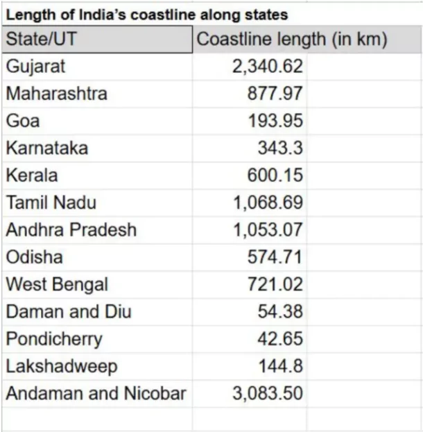
Recently in December 2024, the Union Ministry of Home Affairs reported a significant revision in India’s coastline length.

Coastline Length

  • The length of the coastline was re-assessed by the National Hydrographic Office (NHO) in coordination with the Survey of India (SoI).
  • Previous Length: 7,516 km (as measured in the 1970s).
    Revised Length: 11,098 km (as of 2025) — a 48% increase (~3,582 km).
  • Cause: Not physical expansion but technological improvements in mapping resolution and GIS-based measurement.
  • The new coastline measurement exercise will now be repeated every 10 years.

Key Reasons for Increase in Coastline Length

Coastline Length

  • Higher Data Resolution
    • Old maps used a scale of 1:4,500,000 (1 cm = 45 km).
    • New measurement used 1:250,000 scale (1 cm = 2.5 km).
    • Smaller-scale data smooths coastlines; higher resolution captures bends and curves, increasing total measured length.
  • GIS-Based Techniques: Transition from manual to GIS software allowed for better mapping of land-water boundaries.
    • GIS tools factor in minute geographical irregularities.

The Coastline Paradox

  • The  Paradox was first identified by Lewis Fry Richardson; mathematically explained by Benoît Mandelbrot (1967).
  • Definition: Coastline length is not fixed; it increases with finer measurement resolution.
  • Implication: Natural features like coastlines, riverbanks, and mountain edges are fractals — endlessly divisible with no absolute length.

  • Inclusion of Previously Missed Islands: Offshore island coastlines were not included earlier due to resolution or manual oversight.
    • Inclusion now adds significantly to the total length.
  • Difference due to standardised definitions and data reconciliation among Survey of India, Navy, Coast Guard, and states.
  • Excludes riverine islands (e.g., Assam, West Bengal).

Strategic and Administrative Implications

Change in Number of Islands
Category Number
2016 (Surveyor General) 1,382
Revised count 1,389 total
— Offshore islands 1,298
— Inshore islands 91

  • Coastal Zone Management: CRZ (Coastal Regulation Zone) boundaries may now expand or shift.
    • Planning for habitat conservation, tourism zones, and infrastructure will be affected.
  • Disaster and Climate Resilience: Accurate coastline mapping aids in identifying erosion-prone and submergence zones.
    • Helps plan for cyclone buffers, tidal flood defenses, and mangrove regeneration.
  • Security and Navigation: Maritime surveillance, Navy, Coast Guard operations rely on exact coastline data.
    • Island mapping is crucial for logistics, strategic outposts, and maritime boundary enforcement.
  • Legal and Diplomatic Relevance: While no change in physical territory, recalibration improves claims under UNCLOS for Exclusive Economic Zones (EEZ).
    • Accurate data strengthens India’s Blue Economy and Ocean Diplomacy posture.

Aspect Old Methodology (1970s) New Methodology (2023–24)
Basis of Measurement Straight-line approximation Inclusion of intricate coastal features
Coastal Features Measured Basic shoreline Estuaries, inlets, sandbars, tidal creeks
Scale Used 1:4,500,000 1:250,000
Technology Used Manual, basic mapping tools GIS, LIDAR-GPS, satellite altimetry, drone mapping
Accuracy Less accurate More precise, dynamic representation
Reported Coastline Length 7,516.6 km 11,098.8 km

To get PDF version, Please click on "Print PDF" button.

Need help preparing for UPSC or State PSCs?

Connect with our experts to get free counselling & start preparing

Aiming for UPSC?

Download Our App

      
Quick Revise Now !
AVAILABLE FOR DOWNLOAD SOON
UDAAN PRELIMS WALLAH
Comprehensive coverage with a concise format
Integration of PYQ within the booklet
Designed as per recent trends of Prelims questions
हिंदी में भी उपलब्ध
Quick Revise Now !
UDAAN PRELIMS WALLAH
Comprehensive coverage with a concise format
Integration of PYQ within the booklet
Designed as per recent trends of Prelims questions
हिंदी में भी उपलब्ध

<div class="new-fform">


    </div>

    Subscribe our Newsletter
    Sign up now for our exclusive newsletter and be the first to know about our latest Initiatives, Quality Content, and much more.
    *Promise! We won't spam you.
    Yes! I want to Subscribe.