India and China agreed to the resumption of the Kailash Mansarovar Yatra, trans-border river cooperation, and Nathula border trade.
Lake Mansarovar
- Location: Situated near the foot of Mount Kailash in the Tibet Autonomous Region, China.
- Type of Lake: A freshwater lake, despite the Tibetan Plateau hosting larger saline lakes.
- Source of Water: Replenished by the Kailash Glaciers.
Ecological Significance
- The Brahmaputra originates in the Mansarovar lake.
- The Indus River system also rises near Lake Mansarovar from Bokhar Chu glacier in the Kailash mountain range
|
Enroll now for UPSC Online Classes
About Kailash Mansarovar Yatra
- Holy Site and Significance: Kailash Mansarovar is a revered pilgrimage site for Hindus, Buddhists, Jains, and Bon practitioners.
- Mount Kailash, considered the abode of Lord Shiva, and Lake Mansarovar hold profound spiritual importance.
- It lies in the Gangdisê Mountains (also called as Kailash Range) of the Trans Himalaya, in the western part of the Tibetan Plateau.
- The peak of Mount Kailash is at an elevation of 6,638 m (21,778 ft).
- Duration and Experience: The Yatra typically spans 14-16 days, involving arduous trekking through high-altitude terrain.
-
- Pilgrims experience the natural beauty of the Himalayas, participate in rituals, and perform the circumambulation (parikrama) of Mount Kailash.
Routes to Kailash Mansarovar Yatra

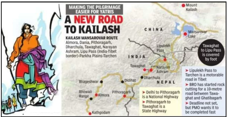
- Lipulekh Pass (Uttarakhand):
- Located in the Himalayas at the tri-junction of India, Nepal, and China (Tibet).
- Situated at a high altitude of approximately 5,334 meters.
- Historically served as a significant trade route.
- It is known as the gateway to Mount Kailash and Om Parvat.
- Offers vantage points to view Mount Kailash and Om Parvat, two sacred peaks revered in Hinduism and other religions.
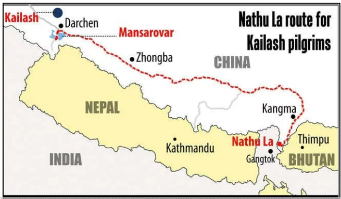
 Nathula Pass (Sikkim): A more accessible and shorter route.
- Suitable for older pilgrims due to fewer trekking requirements.
- The Nathu La is a part of the ancient Silk Road and is one of the three border trading posts between India and China.
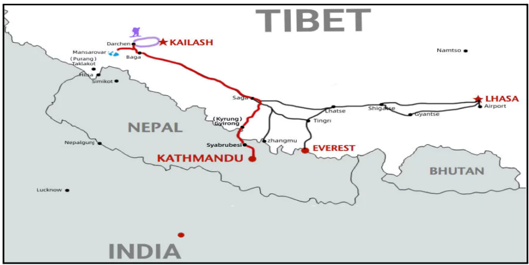
- Via Nepal: An alternative route through Kathmandu and the Nepal-China border.
- Popular among international pilgrims for its flexibility.

Nathu La Pass Trade Route
- The Nathu La Pass is a historic trade route connecting India and China. It reopened in 2006 after being closed since the 1962 Sino-Indian War.
- Trade Route: It is part of Ancient Silk Road located in Sikkim, India it connects with the Tibetan Autonomous Region of China.
- Recent Disruptions: While reopened, trade through Nathu La has been sporadic due to geopolitical tensions between India and China.
- Border clashes in 2020 led to temporary disruptions in trade activities.
- Economic Impact: Despite challenges, the Nathu La Pass holds significant potential for enhancing economic ties between India and China, provided a stable geopolitical environment prevails.
- It has great potential for boosting economic growth in Sikkim and neighboring regions.
|
Check Out UPSC NCERT Textbooks From PW Store
About Transborder River Cooperation
- Trans-border river cooperation between India and China is a complex issue due to geopolitical tensions and varying water needs.
- The two main trans-border rivers are the Brahmaputra (called Yarlung Tsangpo in Tibet) and the Indus.
- Memoranda of Understanding (MoUs): India and China have signed MoUs for the exchange of hydrological data on these rivers, particularly during flood seasons.
- Hydropower development: China’s extensive hydropower projects on the Brahmaputra raise concerns in India about potential downstream impacts on water flow and sediment.
- Data sharing: While there have been efforts to share hydrological data, inconsistencies and delays have often hindered effective cooperation.
- Geopolitical tensions: The overall strained relationship between India and China casts a shadow over trans-border river cooperation, making it difficult to build trust and establish long-term mechanisms.
|
![]() 19 Dec 2024
19 Dec 2024


 Nathula Pass (Sikkim): A more accessible and shorter route.
