Recently, pre-monsoon rain has caused flooding in Bengaluru, known as the Silicon Valley of India.
- Over the past few years, Urban flooding has become one of India’s most urgent challenges in terms of climate and infrastructure, as it affects millions of people across urban centres.
Why Does Bengaluru See Frequent Flooding?
- Topographical Challenges: Located at 900m elevation, lacks a major river for natural drainage.
- Poor Urban Planning & Encroachment: 80% of lakes lost/degraded due to encroachment (2016 report).
- Historically, it had 1,452 lakes (now reduced to ~190), reducing water retention capacity.
- Outdated Drainage System: Rajakaluves (stormwater drains) clogged with waste, inadequate for current rainfall.
- Unregulated construction increases impermeable surfaces, reducing groundwater recharge.
- Climate Change Impact: Intense short-duration rainfall (e.g., 105.5 mm in 24 hrs in May 2025, 2nd highest since 2011).
- IMD data (1969–2019): Bengaluru Urban recorded 73 flooding events (most in South India).
|
About Urban Flooding
- The term urban floods refer to instances when a city receives massive levels of water due to heavy precipitation or other causes (such as cyclone or tsunami), which lead to the submergence of parts of or the entire city, and is coupled with the inability of the city infrastructure to drain the water quickly enough to prevent inundation.
- Concerning Data: As per the data from the government, over 17,000 people died due to floods and heavy rains in India between 2012 and 2021.
- Constitutional Provision: As per 12th Schedule of the Constitution, urban planning including town planning, regulation of land use and construction of buildings is the function of Urban Local Bodies (ULBs)/ Urban Development Authorities.
- The mitigation measures for flood control and preparation of drainage plan comes under the purview of the State Government and Urban Local Bodies/Urban Development Authorities at city level.
- The Government of India supplements the efforts of the States through schematic interventions/ advisories. It provides financial and technical support to the States.
Reasons behind Urban Flooding in India
- Climate Change: Global Climate Change is resulting in changed weather patterns and increased intensity rainfall events occurring in shorter periods.
- Example: Chennai’s record 1,218 mm November 2023 rainfall – its highest in a century – exemplifies climate change intensifying cyclonic activity, with studies showing a 3x increase in such extreme rain events since 1950.
- Urban Heat Island Effect: According to the NDMA, the urban heat island effect has increased rainfall over urban areas.
| Heat islands are urbanized areas that experience higher temperatures than outlying areas. |
-
- The hot air pushes the clouds carrying rain higher as they cross the urban heat island.
- Encroachment in Low Lying Areas: The original built-up area of Indian cities has expanded and new developments are taking place in low-lying areas of Indian cities and towns due to rising land prices and less availability of land in the cities.
- Most of the time, these developments take place on encroachments over lakes, wetlands, and riverbeds.
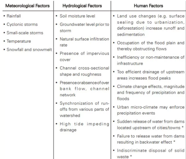 Sea Level Rise: Cities and towns that are near rivers, the ocean, interior cities, dams, and steep terrain are severely impacted due to sea level rise.
 -
- For Example: Satellite observations have revealed that the rate of sea level rise is increasing and it rose by 0.11 inches from 2021 to 2022.
- Faulty Drainage System: The urban areas lack adequate drainage infrastructure capable of handling heavy rainfall events.
- The issue is exacerbated by concretizing the drains and preventing the water from seeping to the ground.
- Urbanisation: Rapid urbanisation, both planned and unplanned, is responsible for flooding.
- Grey infrastructure which includes the flyovers, widening of roads, urban settlements, contribute towards urban flooding in waterlogged areas.
- The recent floods in Bengaluru are examples of such planning failures.
- Loss of Water Bodies and Green Spaces: A study by the National Institute of Urban Affairs revealed that major Indian cities have lost 70-80% of their water bodies over the last 40 years.
- This has led to reduced natural water storage capacity, increased surface runoff, and disruption of the natural water cycle.
- Lack of Effective Urban Governance: Despite the 74th Constitutional Amendment Act, key areas such as urban planning, land use and economic development have not fully transferred to city governments as required.
- This leads to poor urban governance and mismanagement.
- Illegal Mining: Illegal mining of river sand and quartzite causes soil erosion and reduces the water retention capacity of the waterbody increasing the speed and scale of water flow.
- Example: Jaisamand Lake-Jodhpur, Cauvery river-Tamil Nadu, etc.
Impact of urban flooding:
- Tangible losses: The losses that can be measured physically and can be assigned an economic value. These losses can be direct or indirect.
- Direct: Structural damage to buildings, property damage, damage to infrastructure
- Indirect: Economic losses, Traffic disruption, and emergency costs.
- Intangible losses: Intangible losses include loss of life, secondary health effects, and infections or damages to the environment which are difficult to assess in monetary terms since they are not traded.
-
- Direct: Casualties, Health effects, ecological losses
- Indirect: Post-flood recovery process, mental damage to the people
|
Action taken by Government To Combat with Urban Flooding
Institutional Framework and Arrangement
- National Disaster Response Force (NDRF): The Disaster Management Act 2005 has mandated the constitution of the NDRF for the purpose of specialized response to a threatening disaster situation or disaster.
- The National Crisis Management Committee (NCMC): It comprises high-level officials of the GoI, headed by the Cabinet Secretary, will also deal with specified major crises.
- Central Water Commission (CWC): Flood forecasts are issued by the CWC in India. It provides a near real time five-day advisory flood forecast on its web portal.
- National Disaster Management Authority: NDMA is the apex body in India for disaster management.
- Pre-Monsoon Phase:
- Preparedness: Planning for Disaster Reduction: Focus on plans to respond to a threat or occurrence of urban flooding.
- National Hydro-meteorological Network
- National Meteorological Network
- Local Networks for Real time Rainfall data
- Doppler Weather radars
- During Monsoon Phase:
- Early Warning: Measures to provide timely, qualitative and quantitative warnings to urban flooding based on the intensity of rainfall.
- Effective Response and Management: Focuses primarily on emergency relief measures.
- Post-Monsoon Phase:
- Restoration and Rehabilitation: Necessary measures to stabilize the vulnerable situation and restore the utilities.
Various Government Initiatives to Curtail Urban Flooding
- Jal Shakti Abhiyan: It is implemented with special emphasis being given for rainwater harvesting/groundwater recharge.
- Amrit Sarovar Mission: The initiative was launched under Azadi ka Amrit Mahotsav to develop and rejuvenate 75 water bodies per district nationwide.
- These revitalized water bodies will serve dual purposes – enhancing rainwater harvesting capacity while commemorating India’s 75 years of independence through sustainable water conservation efforts.
- Atal Bhujal Yojana: The initiative emphasizes demand-side groundwater management through water-saving interventions.
- Key measures include promoting micro-irrigation (drip/sprinkler systems), transitioning to less water-intensive crops, and adopting mulching practices, all supported by government incentives.
- Atal Mission for Rejuvenation and Urban Transformation (AMRUT) 2.0: The policy mandates rainwater harvesting by channeling stormwater drains into uncontaminated water bodies (free from sewage/effluent).
- It also prioritizes constructing and reinforcing stormwater drainage systems around these water bodies to enhance urban flood resilience.
- Model Building Bye Laws (MBBL): The Ministry of Housing & Urban Affairs (MoHUA) has formulated Model Building Bye Laws (MBBL), 2016 for the States/UTs.
- As per MBBL, all buildings having a plot size of 100 sq.m. or more shall mandatorily include the complete proposal of rainwater harvesting.
Global Best Practices to Tackle Urban Flooding:
- Sponge City Concept (China): Uses permeable pavements, rain gardens, and wetlands to absorb rainwater.
- Chinese cities like Shanghai reduced flood risks by 60% through large-scale sponge infrastructure projects.
- Sustainable Drainage Systems (UK – SuDS): Replaces concrete drains with natural filtration systems like bioswales.
- London’s SuDS projects cut flood incidents significantly while recharging groundwater.
- Underground Stormwater Tunnels (Japan): Massive subsurface tunnels store excess rainwater during heavy storms.
- Tokyo’s Metropolitan Area Outer Underground Discharge Channel prevents floods even during typhoons.
- Smart Flood Monitoring (Singapore): IoT sensors in drains provide real-time flood warnings via public alerts.
- Singapore’s Smart Water Assessment Network (SWAN) reduced flood-prone areas by 50%.
- Blue-Green Infrastructure (Netherlands): Integrates canals, parks, and green roofs to manage water flow.
- Rotterdam’s water squares store 1.8 million liters of rainwater, doubling as public spaces.
|
Way Forward to Tackle Urban Flooding in India
- Early Warning and Technological Integration: Establish robust early alert systems using sensors and real-time data, as seen in Buenos Aires.
- Geospatial technologies and satellite data should also be used for flood vulnerability mapping, especially in informal settlements.
- Mandatory Climate Action Plans (CAPs): Amend municipal statutes to make CAPs a statutory obligation for cities, ensuring annual implementation with dedicated budgetary allocations and oversight by a climate cell.
- Sustainable and Climate-Resilient Urban Planning: Embrace planning that respects natural topography and hydrology. Integrate green spaces, construct flood-resilient infrastructure.
- Adopt the “Sponge Cities” model to absorb excess rainwater effectively.
- Improved Drainage and Water Management: Upgrade and regularly maintain stormwater drainage systems.
- Include rainwater harvesting and bioswales in infrastructure design to improve percolation and reduce runoff.
- Decentralized and Balanced Urban Development: Develop and incentivize growth in smaller cities to reduce migration pressure on metros.
- A national policy should discourage over-densification, aiming for sustainable economic and environmental outcomes.
- Nature-Based and Blue-Green Infrastructure: Restore wetlands, urban forests, and water bodies.
- Promote blue-green infrastructure that combines ecological restoration with urban design to manage stormwater and improve urban resilience.
Innovative Infrastructure Solutions:
- Green Roofs and Infiltration Beds: Promote green roofs and infiltration beds to compensate for lost ground permeability, guiding rainwater through underground pipes.
- Rooftop Rainwater Harvesting Tanks: Encourage widespread installation of rooftop tanks to reduce floodwater volume significantly (e.g., a 1000m³ tank can reduce overflows by 43%).
- Permeable Pavements: Adopt permeable pavements to reduce surface runoff and enhance water absorption.
- Underground Storage Systems: Implement large-scale underground stormwater storage schemes, like Hong Kong’s Tai Hang Stormwater Storage Tank, to manage excess water.
|
- Collaborative Governance and Capacity Building: Create institutional mechanisms involving governments, civil society, academia, and industry.
- Build citizen awareness and launch large-scale education programs on disaster risk reduction and climate adaptation.
- Citizen Education and Behavioral Change: Launch a nationwide education program to instill disaster risk reduction behaviors in citizens, integrating risk mitigation into daily life, livelihoods, and occupational patterns.
- Emerging Technologies: Using AI and machine learning to predict flood scenarios and optimize flood management strategies.
- Employing digital twins to simulate flood scenarios and assess the effectiveness of different interventions.
Conclusion
Bengaluru’s recurring floods highlight the urgent need for sustainable urban planning, robust drainage systems, and nature-based solutions. Adopting global best practices like sponge cities and smart monitoring, alongside collaborative governance, can enhance resilience and mitigate future flood risks.


 24 May 2025


.png)


 Current Affairs


 GS Foundation
 Optional Course
 Combo Courses
 Degree Program