To prevent floods and landslides as recently seen in Kerala’s Wayanad district in the future, the Union Ministry of Earth Sciences approved the installation of an X-band radar in Wayanad.
X-Band Radar in Wayanad Boosts Landslide Early Warning System
- This radar aims to enhance early warning systems by monitoring environmental changes that can trigger landslides.
 The X-band radar installed in Wayanad will play a key role in monitoring the movements of soil particles, which are indicators of potential landslides.
 - With its high temporal sampling capability, the radar can detect rapid changes in the environment, allowing for more accurate and timely disaster warnings.
Doppler Radar and Its Application in Meteorology
- Doppler Radar (Radio Detection and Ranging) uses electromagnetic waves in the microwave range to detect location, direction, altitude, intensity, and movement of objects.
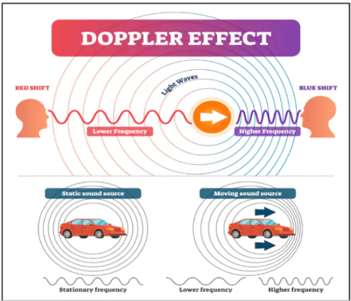
- Doppler radar is based on the Doppler effect, which describes the change in frequency of a signal when the source and observer are in relative motion.
- If objects move closer, the frequency increases
- In meteorological applications, Doppler radars help forecasters observe rainfall, track cloud formations, and monitor thunderstorms in real-time.
- By detecting the movement of particles, they can provide valuable data on storm intensity and wind direction.
Enroll now for UPSC Online Course
What is RADAR?
- Radar is an acronym for “Radio Detection And Ranging.”
- It is a technology that uses radio waves to detect objects and measure the range, angle, or velocity of those objects
How Does Radar Work?
- Radar works by emitting a pulse of electromagnetic radiation in a specific direction.
- When this pulse hits an object, some of the energy is reflected back to the radar unit.
- By measuring the time it took for the pulse to return as well as its strength, radar can be used to determine how far away an object is, what direction it’s moving in, and even what type of object it is.
What are Electromagnetic Waves?
- Electromagnetic waves are energy waves that travel through space at the speed of light, consisting of oscillating electric and magnetic fields.
- Radar uses microwaves, a type of electromagnetic wave, for long-range detection and weather monitoring.
|
Types of Doppler Radars: L, S, C, X, and K Bands
- L-band radar: Low frequency (1-2 GHz), long wavelengths (15-30 cm), suitable for detecting large-scale weather patterns.
- S-band radar: Operates at 2-4 GHz, with wavelengths of 8-15 cm. It is useful for both near and far-range weather detection due to its resistance to signal attenuation.
- C-band radar: Works within 4-8 GHz frequency and 4-8 cm wavelength, primarily used for short-range weather observations.
- X-band radar: Focuses on smaller particles and shorter-range weather monitoring, due to its 8-12 GHz frequency and 2-4 cm wavelength.

Role of X-Band Radar
- The shorter wavelength allows X-band radar to detect smaller particles, such as rain droplets and soil, providing high-resolution imaging.
- However, due to the shorter wavelength, X-band radars have a relatively limited detection range compared to other radar types like C-band or S-band.
India’s Growing Radar Network
- India’s India Meteorological Department (IMD) began using radar technology in the 1950s, installing its first indigenous X-band radar in 1970.
- Both X-band and S-band radars are used extensively across the country.
- Mission Mausam: The Indian government plans to add 56 additional Doppler radars, modernising its meteorological infrastructure under the ₹2,000 crore ‘Mission Mausam’ initiative.
- This includes the installation of up to 60 radars by 2026 to improve weather forecasting.
Check Out UPSC Modules From PW Store
Future Projects
- India, in collaboration with NASA, is developing the NISAR satellite (NASA-ISRO Synthetic Aperture Radar), which is expected to launch in 2025.
- NISAR will combine L-band and S-band radars to produce high-resolution maps of the Earth’s surface, helping track natural processes such as land deformation and environmental changes.
- This satellite will enhance the country’s ability to monitor and respond to geological activities and weather phenomena.
![]() 14 Oct 2024
14 Oct 2024
 The X-band radar installed in Wayanad will play a key role in monitoring the movements of soil particles, which are indicators of potential landslides.