chjdsbhjdbfhrb

Malwa Plateau: Geography, Rivers, Climate, History Explained

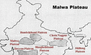
Malwa Plateau in central India spans Madhya Pradesh and Rajasthan. Formed by Deccan Trap lava, it has fertile black soil and supports major agriculture. Rivers like the Chambal and Betwa drain the region. With a tropical climate and rich history, it remains geographically and culturally significant.

Malwa Plateau: Geography, Rivers, Climate, History Explained

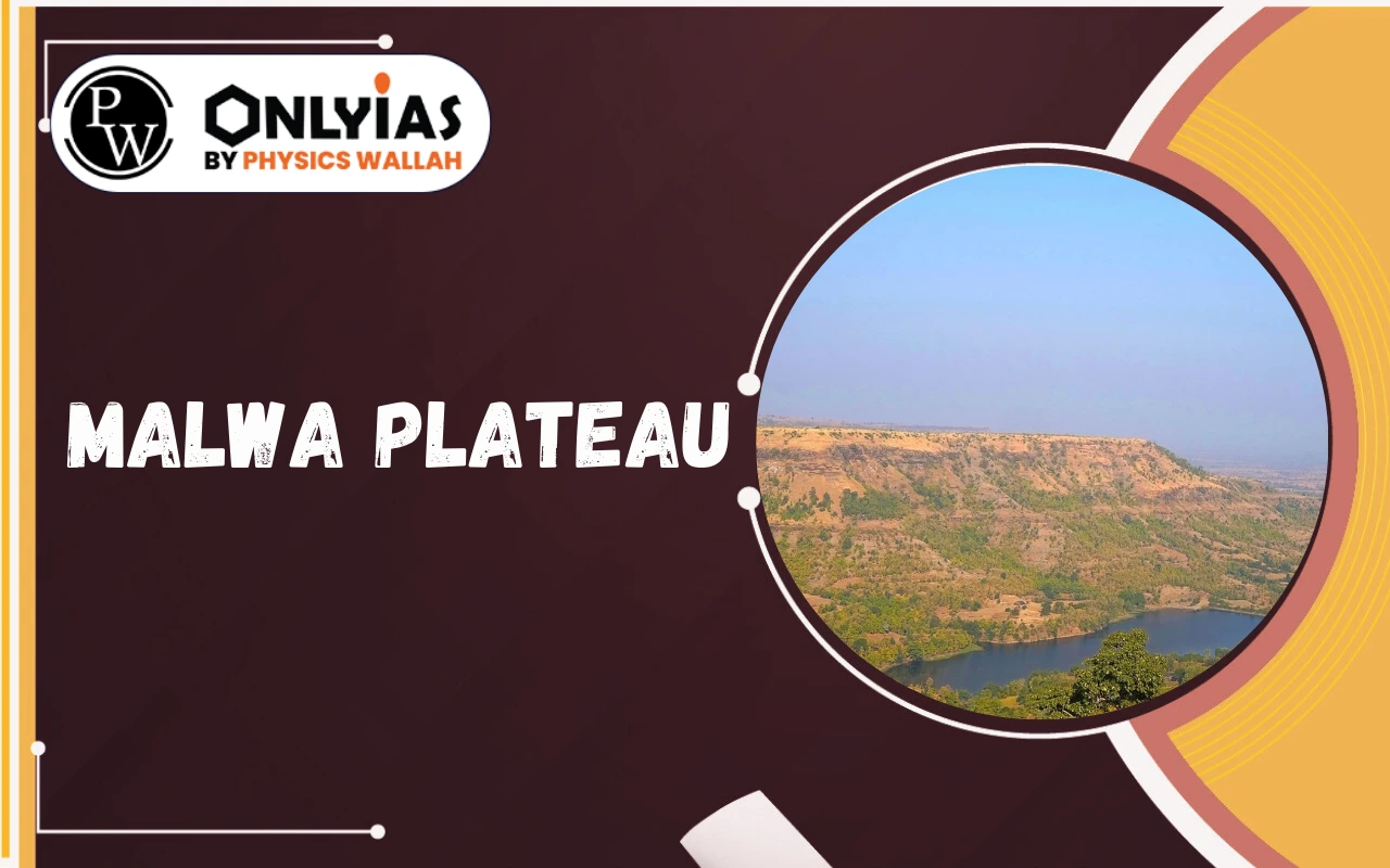
The Malwa Plateau is an important geographical region in central India, extending across parts of Madhya Pradesh and southeastern Rajasthan. It was formed by ancient volcanic activity associated with the Deccan Traps, which gave rise to its characteristic basaltic landscape and fertile black soil.

This rich soil supports extensive agriculture, making the region agriculturally productive. Several important rivers, including the Chambal River and Betwa River, flow through and drain the plateau.

With its tropical climate, productive land, and long historical background, the Malwa Plateau holds both geographical and cultural significance in India. Read on to learn more about the Malwa Plateau.

About Malwa Plateau

The Malwa Plateau is an elevated landform in west-central India. It was formed by ancient volcanic activity. Because of this origin, the region has deep black soil and a gently rolling surface.

The soil is very fertile, so farming is an important activity here. The plateau is also known for its rich historical background. For these reasons, it is an important region in Indian geography.

Enroll now for UPSC Online Course

Structure

  • Formed from volcanic lava flows (Deccan Trap origin).
  • Surface shaped by erosion, creating:
    • Flat-topped mesas
    • Occasional sandstone hills
  • Composed mainly of basaltic rock.

Boundaries

  • North: Madhya Bharat Plateau and Bundelkhand Upland
  • East & South: Vindhya Range
  • West: Gujarat Plains
  • Covers central Madhya Pradesh and southeastern Rajasthan.

Malwa Plateau

Historical Significance of Malwa Plateau

The Malwa Plateau has a rich history. It has been a significant cultural and political center serving as a strategic crossroads linking northern and western India.

  • Origin of Name: “Malav” means “part of the abode of Lakshmi.”
  • Ancient Period: It was part of the Avanti kingdom. Ujjain, a city on the Malwa Plateau, was a key center for trade and learning. It is also one of Hinduism’s seven sacred cities.
  • Medieval Period: Various dynasties ruled Malwa, including the Paramaras, Delhi Sultanate, Mughals, and Marathas. Conquered by Muslim rulers in 1390 CE.
  • Buddhist Heritage: Major centre of Buddhist architecture and sculpture. Famous monuments include the stupas at Sanchi, known for intricate carvings and gateways (toranas).

Malwa Plateau Geographical Features

The Malwa Plateau is a major physiographic unit. Its geology reflects ancient volcanic origins.

  • Location and Extent: The plateau stretches across western Madhya Pradesh and southeastern Rajasthan. It is bordered by the Gujarat Plains in the west. The Vindhya Range lies to the south and east. The Bundelkhand Upland forms its northern boundary.
  • Formation and Geology: The plateau was formed by lava flows from the Deccan Traps. This happened about 60–68 million years ago. Because of this volcanic origin, the land has basalt rocks and fertile black soil.
  • Elevation: The average height of the plateau is about 500 meters above sea level. Some higher points, such as Sigar, rise up to about 881 meters. The land generally slopes toward the north.
  • Terrain: It features undulating hills and wide river valleys. The landscape includes scattered ridges.

Malwa Plateau Rivers

Several important rivers drain the Malwa Plateau. They are crucial for irrigation and local ecosystems.

Major Rivers

  1. Mahi River
  2. Chambal River
  3. Betwa River
  4. Dhasan River (headwaters)
  5. Ken River (headwaters)

Other Rivers

  • Parbati River
  • Shipra River (also spelled Sipra)
  • Gambhir River
  • Kali Sindh River (Choti Kali Sindh)

Drainage Pattern 

Most rivers flow northward into the Yamuna. The Mahi River flows westward into the Arabian Sea. These rivers create terraced valleys and gorges. The Chambal river Malwa plateau is known for its ravines.

Malwa Plateau Climate

The Malwa Plateau experiences a specific climate pattern. This influences its vegetation and agricultural cycles.

  • Climate Classification: It has a tropical wet and dry climate (Aw). This classification highlights distinct wet and dry seasons.
  • Seasonal Characteristics: Summers are hot, with temperatures often reaching 30-45°C. The monsoon season, from June to September, brings 900-1,200 mm rainfall. Winters are mild, ranging from 10-25°C, with colder nights.

Malwa Plateau Vegetation

The natural vegetation reflects the tropical wet and dry climate. However, agriculture widely reshaped the landscape.

  • Dominant Type: Tropical dry forests are common. Deciduous trees like teak and sal shed leaves in dry periods.
  • Soil: Predominantly black cotton soil (regur) derived from volcanic rock. Highly fertile and suitable for crops like cotton and cereals.
  • Undergrowth and Grasslands: Shrubs like Grewia and Ziziphus grow here. Grasslands support grazing animals.

Agricultural Land: Extensive areas cleared for farming. The black soil supports crops like wheat, rice, pulses, and oilseeds. Cotton and sugarcane are also grown.

Check Out UPSC CSE Books

Visit PW Store
online store 1

Frequently Asked Questions

Which states primarily encompass the Malwa Plateau?

The Malwa Plateau mainly covers parts of Madhya Pradesh and southeastern Rajasthan.

What type of soil is characteristic of the Malwa Plateau?

The plateau is characterized by fertile black cotton soil, also called 'regur'.

Name two major rivers flowing through the Malwa Plateau.

The Chambal River and the Betwa River are two major rivers of the Malwa Plateau.

What is the climate of the Malwa Plateau?

The Malwa Plateau experiences a tropical wet and dry (Aw) climate with hot summers, monsoons, and mild winters.

What is the Malwa Plateau's geological origin?

It formed from the volcanic Deccan Traps lava flows.

Malwa Plateau: Geography, Rivers, Climate, History Explained

Enroll in SRIJAN Prelims Crash Course

Need help preparing for UPSC or State PSCs?

Connect with our experts to get free counselling & start preparing

Aiming for UPSC?

Download Our App

      
Quick Revise Now !
AVAILABLE FOR DOWNLOAD SOON
UDAAN PRELIMS WALLAH
Comprehensive coverage with a concise format
Integration of PYQ within the booklet
Designed as per recent trends of Prelims questions
हिंदी में भी उपलब्ध
Quick Revise Now !
UDAAN PRELIMS WALLAH
Comprehensive coverage with a concise format
Integration of PYQ within the booklet
Designed as per recent trends of Prelims questions
हिंदी में भी उपलब्ध

<div class="new-fform">


    </div>

    Subscribe our Newsletter
    Sign up now for our exclusive newsletter and be the first to know about our latest Initiatives, Quality Content, and much more.
    *Promise! We won't spam you.
    Yes! I want to Subscribe.