Books

Mountain ranges in India form a diverse physical landscape, from the young Himalayas in the north to the ancient Aravalli, Vindhya, Satpura, Western Ghats, and Eastern Ghats. They influence climate, rivers, biodiversity, and are key topics for geography and competitive exam preparation.

Mountain Ranges in India are among the most spectacular and diverse mountain systems in the world, stretching from the snow-capped peaks of the North to the lush green ridges of the South. These ranges play a crucial role in shaping the country’s climate, act as the source of perennial rivers, and serve as natural barriers. Understanding these mountain ranges is essential for geography enthusiasts and competitive exam aspirants alike.
For students and aspirants preparing for competitive exams like UPSC, understanding the geography of the major mountain ranges of India including their peaks, passes, and river systems is essential for the Geography and Environment sections of the syllabus.
The list of mountain ranges in India can be broadly categorized into Northern India (Himalayan system) and Peninsular India (Deccan and coastal systems). These ranges are not just geographical features but are the lifelines of the Indian subcontinent, hosting rich biodiversity and influencing the monsoon patterns.
| Mountain Ranges in India Overview | |
| Aspect | Details |
| Highest Mountain Ranges in India | The Great Himalayas |
| Oldest Mountain Range | Aravalli Range |
| Primary River Sources | Himalayas (Indus, Ganga, Brahmaputra) |
| Biodiversity Hotspot | Western Ghats (Sahyadri) |
| Highest Peak in India | Kanchenjunga (8,586 m) / K2 (Karakoram Range) |
Note: While the Himalayas are the most prominent, the mountain ranges of peninsular India like the Western and Eastern Ghats are equally significant for their ecological and economic contributions.
This section explores the diverse mountain ranges in India, categorized by their geographical location and geological characteristics. Each major range includes key features and regional tables for structured understanding.
The Himalayas are young fold mountains formed by the collision of tectonic plates. They define India’s northern border and divide into three parallel ranges. The system includes the Greater, Middle, and Outer Himalayas.
| Himalayan Mountain Ranges in India | |||
|---|---|---|---|
| Mountain Range | States | Highest Peak | Remarks |
| Greater Himalayas | India, Nepal, Bhutan | Mount Everest (Nepal) | Northernmost, highest peaks |
| Middle Himalayas | J&K, Himachal, Uttarakhand | Pir Panjal, Dhauladhar | Famous hill stations |
| Outer Himalayas (Shivalik) | Indus to Brahmaputra | – | Outermost, youngest range, Doons & Duars |
These ranges lie immediately north of the Great Himalayas. They extend parallel to the main Himalayan range in a west-east direction.
| Trans-Himalayan Ranges | |||
|---|---|---|---|
| Mountain Range | States | Highest Peak | Remarks |
| Karakoram Range | Ladakh, PoK | K2 (Godwin-Austen) | Highest peak in India (disputed region) |
| Ladakh Range | J&K | – | Between Shyok and Indus rivers |
| Zanskar Range | J&K | Kamet Peak (7,756m) | Between Great Himalayas and Ladakh |
The Purvanchal Range represents the eastern extension of the Himalayas. It runs along India’s eastern boundary with Myanmar.
| Purvanchal Range (Eastern Mountains) | |||
|---|---|---|---|
| Mountain Range | States | Highest Peak | Remarks |
| Patkai Bum | Arunachal Pradesh | – | Forms India-Myanmar border |
| Naga Hills | Nagaland | Mount Saramati | Part of Purvanchal |
| Mizo Hills | Mizoram | Phawngpui (Blue Mountain) | Southernmost Purvanchal |
| Manipur Hills | Manipur | – | Loktak Lake located here |
These ancient mountain ranges of peninsular India are typically older and heavily eroded. They represent relicts of once taller mountain systems.
| Peninsular Indian Mountain Ranges | |||
|---|---|---|---|
| Mountain Range | States | Highest Peak | Remarks |
| Aravalli Range | Gujarat, Rajasthan, Haryana, Delhi | Guru Shikhar (1,722 m) | Oldest fold mountains |
| Vindhya Range | Gujarat, MP, UP, Bihar, Chhattisgarh | Sad-Bhawna Shikhar (752 m) | Boundary between North and South India |
| Satpura Range | Gujarat, Maharashtra, MP, Chhattisgarh | Mount Dhupgarh (1,350 m) | Between Narmada and Tapi rivers |
The Western Ghats mountain range is a continuous chain along India’s western coast. It is a UNESCO World Heritage Site and a major biodiversity hotspot.
| Western Ghats Mountain Range | |||
|---|---|---|---|
| Mountain Range | States | Highest Peak | Remarks |
| Sahyadri | Maharashtra | – | Local name for Western Ghats in Maharashtra |
| Nilgiri Hills | Tamil Nadu, Kerala, Karnataka | Doddabetta (2,637 m) | Eastern & Western Ghats meet |
| Anaimalai Hills | Tamil Nadu, Kerala | Anamudi (2,695 m) | Highest peak in South India |
| Cardamom Hills | Tamil Nadu, Kerala | – | Southernmost part of Western Ghats, spice cultivation |
The Eastern Ghats mountain range forms a discontinuous chain along India’s eastern coast. It is highly eroded by major east-flowing rivers.
| Eastern Ghats Mountain Range | |||
|---|---|---|---|
| Mountain Range | States | Highest Peak | Remarks |
| Nallamala Hills | Andhra Pradesh, Telangana | – | Extensive forests |
| Javadi Hills | Tamil Nadu | – | Located in northern Tamil Nadu |
| Seshachalam Hills | Andhra Pradesh | – | Famous for Tirupati City |
| Jindhagada Peak | Andhra Pradesh | Jindhagada Peak (1,690 m) | Highest peak in the Eastern Ghats |
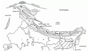
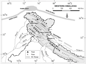
India’s northern and north-eastern regions are dominated by some of the most significant and highest mountain ranges in the world. These mountain ranges of northern India form the backbone of the country’s topography and influence climate, river systems, and biodiversity. They include young fold mountains, high peaks, and important passes that have strategic and historical significance.
The northern region of India is primarily defined by the Himalayan mountain ranges in India, which can be divided into three parallel ranges:
| Major Mountain Ranges of Northern India | |||
| Mountain Range | Location | Notable Peaks | Remarks |
| Greater Himalayas (Himadri) | Jammu & Kashmir, Himachal Pradesh, Uttarakhand | Kanchenjunga (8,586 m) | Northernmost and highest range, perennial rivers originate here |
| Middle Himalayas (Himachal) | J&K, Himachal Pradesh, Uttarakhand | Pir Panjal Range, Dhauladhar | Famous for hill stations like Shimla, Mussoorie |
| Outer Himalayas (Shivalik Range) | Punjab to Assam | — | Youngest range, forms fertile Doons & Duars valleys |
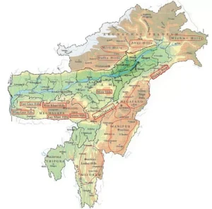
The mountain ranges in north east India form a continuation of the Himalayan system, often referred to as the Purvanchal Range. These ranges are rugged, forested, and include several smaller hills and plateaus.
| Mountain Ranges in North East India | |||
| Mountain Range | State | Highest Peak | Remarks |
| Patkai Hills | Arunachal Pradesh | — | Forms India-Myanmar border |
| Naga Hills | Nagaland | Mount Saramati | Part of Purvanchal, rich in biodiversity |
| Mizo Hills (Lushai Hills) | Mizoram | Phawngpui (Blue Mountain) | Southernmost Purvanchal |
| Manipur Hills | Manipur | — | Includes Loktak Lake and forested valleys |
Northern India is home to several important mountain passes in India, which historically served as trade routes and invasion corridors. Examples include:
A mountain ranges map of India helps visualize the distribution of these northern and north-eastern ranges along with their major peaks and passes. This map is a handy tool for competitive exam preparation and geography studies.
Check Out UPSC CSE Books
Visit PW Store
India’s diverse mountain ranges form through distinct geological mechanisms. The Himalayas and Trans-Himalayas are classic examples of young fold mountains. They arise from the collision of the Indian and Eurasian tectonic plates. This immense pressure causes the Earth’s crust to fold and uplift into high peaks. Peninsular ranges, like the Aravallis, are ancient residual mountains. They formed millions of years ago, and erosion has since worn them down. The Vindhya and Satpura ranges are block mountains, created by faulting and uplifting. These mechanisms explain the varied geological features across the subcontinent.
Fold mountains form when two or more tectonic plates push together. This compression causes rocks and debris to buckle and fold. The Himalayas are young fold mountains.
Residual mountains are remnants of older, larger mountain ranges. Erosion by wind, water, and ice wears down softer rocks. Harder, more resistant rock remains, forming residual mountains like the Aravallis.
Block mountains develop from faults in the Earth’s crust. Tectonic forces create fractures. Blocks of crust are uplifted, forming mountains, while others subside, forming valleys. The Vindhya and Satpura ranges are examples.
Ready to boost your UPSC 2026 preparation? Join PW’s UPSC online courses today!
Explore UPSC Test Series

The Karakoram Range hosts K2 (Mount Godwin-Austen), considered the highest peak in India at 8,611 meters, though located in a disputed territory. Kangchenjunga (8,598 m) is the highest undisputed peak in India.
Fold mountains form when tectonic plates collide, causing the Earth's crust to fold. The Himalayas are a prime example of young fold mountains in India.
The Vindhya Range is considered the traditional boundary separating North and South India.
Key mountain ranges of peninsular India include the Aravalli Range, Vindhya Range, Satpura Range, Western Ghats, and Eastern Ghats.
The Western Ghats are famous for being a biodiversity hotspot and a UNESCO World Heritage Site, influencing India's monsoon patterns and featuring abundant flora and fauna.


Explore SRIJAN Prelims Crash Course

Connect with our experts to get free counselling & start preparing
Books
Udaan (Prelims Wallah)
Prahaar (Mains Wallah)
Q&A Bank (Prelims & Mains)
Budget & Economic Survey
NCERT Wallah
Marks Booster
हिंदी माध्यम विशेष शृंखला
 Current Affairs
Monthly Current Wallah
Subject Wise Current Affairs
Editorial Analysis
Editorial PDFs
News of The Day
Download Our App


Download Our App
<div class="new-fform">
</div>
 GS Foundation
 Optional Course
 Combo Courses
 Degree Program