NCERT NOTES

Elevate your UPSC preparation with NCERT Notes – because every word matters on your journey to success.

Coastal Landforms: Coastal Erosion, Desert Formation

November 30, 2023 1305 0

Dynamics of Coastal Features and Ever-Changing Landforms

Landforms, including coastal features, are the different shapes and features on the Earth’s surface, and they change over time because of things like water, wind and other natural forces, creating a constantly evolving landscape.

In this chapter, we will study different landforms and geographical agents, including coastal elements which play a major role in forming these landforms. 
Coastal Erosional Landforms

  • Coastal Wave cut cliffs: They are steep and tall rock formations along the shore, reaching heights of up to 30 meters.
  • Coastal Wave cut terraces: Flat platforms made of rock debris at the base of cliffs, elevated above the average wave height.
    • Wave-cut cliffs and terraces are major landforms where erosion is the dominant process.
  • Caves: Hollows formed by the impact of waves and rock debris against cliffs. 
    • Roofs of these caves collapse giving way for stacks.
  • Sea Stacks: Resilient rock masses, originally part of cliffs or hills, standing alone just off the shore. 
    • They are temporary and will eventually erode into narrow coastal plains.

Formation and Evolution of Coastal Depositional Landforms

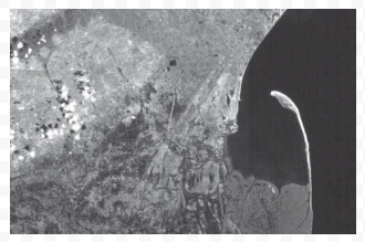
A satellite picture of a part of Godavari river delta showing a spit

A satellite picture of a part of Godavari river delta showing a spit

Understanding the Dynamic Nature of Coastal Beaches

  • Coastal shoreline areas primarily formed by deposition
  • Sediments on coastal beaches are often sourced from land carried by rivers or waves. 
  • Beaches are not permanent and can change in size and composition seasonally. 
    • Most beaches consist of sand-sized materials, while others may have smaller pebbles and cobbles, known as shingle beaches.

The Formation of Coastal Sand Dunes

  • Sand lifted and sorted from the beach surface is deposited just behind the beach, forming sand dunes. 
    • These dunes are commonly found along low sedimentary  coastal area and appear as long ridges parallel to the coastline.

Off-shore Bar: 

  • It is a ridge of sand and shingle that forms in the sea in the off-shore zone, typically running parallel to the coast.

Barrier Bar:  

  • It is a coastal off-shore bar that becomes exposed due to the accumulation of sand.

Spit: 

  • It is a type of barrier bar that may extend from the mainland to an island, headland, or across the entrance of a bay.
  • These features often develop at the mouth of a river or bay
  • Over time, they can extend and restrict the opening of a bay into the sea, eventually leading to the formation of a lagoon. 
  • Lagoons gradually fill up with sediment from the land and the beach, creating a wide coastal plain.

Do You Know?

The coastal off-shore bars offer the first buffer or defense against storm or tsunami by absorbing most of their destructive force. Then come the barriers, beaches, beach dunes and mangroves, if any, to absorb the destructive force of storm and tsunami waves. So, if anything is done which disturbs the ‘sediment budget’ and the mangroves along the coast, these coastal forms will erode away leaving human habitations to bear the first strike of storm and tsunami waves.
Power of Wind Erosion and Deposition

  • Wind Erosion and Deposition: Wind is a major force in hot deserts
    • Desert surfaces heat up quickly due to their arid nature, causing the air above them to rise, creating turbulence and various wind patterns.
    • These winds can move rapidly across the coastal desert floor, leading to turbulence when they encounter obstacles. 
    • Storm winds, which are occasionally present, can be highly destructive.
  • Winds contribute to erosion through deflation, abrasion, and impact.
    • Deflation involves lifting and removing dust and small particles from rock surfaces. 
      • During transportation, sand and silt act as effective tools, abrading the land.
    • Impact, on the other hand, is the sheer force generated when sand collides with coastal rock surfaces, similar to a sand-blasting operation. 
  • Occasional Torrential Rain: Desert landscapes are also shaped by occasional torrential rain, despite the region’s low overall precipitation. 
    • These heavy rains cause mass wasting and sheet flooding. 
  • Desert rocks, exposed to extreme diurnal temperature fluctuations, weather quickly, and torrential rain helps wash away weathered material. 
  • Thus, wind-driven erosion and deposition create distinctive features in deserts.

Desert Erosional Landforms: How Wind Shapes the Landscape

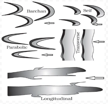
Various types of sand dunes. Arrows indicate wind direction.

Various types of sand dunes. Arrows indicate wind direction.

Pediments and Pediplains:

  • Desert landscape evolution primarily revolves around the creation and expansion of pediments. 
  • Pediments are gently inclined rocky surfaces found near the bases of mountains, sometimes covered with a thin layer of debris. 
    • They form through a combination of lateral erosion by streams and sheet flooding.
  • Erosion: It occurs along the steep margins of landmasses or steep sides of tectonically controlled incision features. 
  • Pediments consist of a steep wash slope and a cliff or free face above it.
  • Erosion of these features involves a process called parallel retreat of slopes, where the wash slope and free face gradually move backwards.
    • This process leads to the extension of pediments at the expense of mountain fronts. 
  • Over time, the mountains reduce in size, leaving behind inselbergs as remnants. 
  • Ultimately, the high-relief desert areas transform into low, featureless plains known as pediplains.

Playas:

  • Playas are shallow lakes formed at the center of basins surrounded by mountains and hills. 
    • Playas have short-lived water retention due to high evaporation rates and often contain salt deposits. 
    • Playa plains covered with salts are called alkali flats.

Deflation Hollows and Caves:

  • Deflation Hollows are shallow depressions created by wind-blown sand and persistent wind currents. 
    • Wind-driven sand impacts and abrades rock surfaces, forming blowouts that may develop into caves.

Mushroom, Table, and Pedestal Rocks:

  • Resistant rock remnants polished by wind erosion take on various shapes such as, 
    • Mushroom rocks which have a slender stalk and a rounded, pear-shaped cap.
    • Table rocks have broad, flat tops.
    • Pedestal rocks stand tall like pillars.

Desert Depositional Landforms:

  • Wind, while performing depositional activities, acts as a sorting agent, transporting grains of different sizes based on wind velocity.
  • Grains settle out of suspension when wind slows down, leading to good grain sorting. 
  • Wind-driven deposition can occur in arid regions with constant wind and a sand source.

Sand Dunes:

  • Dry, hot deserts are ideal for sand dune formation.
  • Dune formation requires both sand availability and obstacles. Various dune forms include:
    • Barchans: It is crescent shaped dunes with wings directed away from wind direction. 
    • Parabolic dune: It is formed when the sandy surface is covered with vegetation. 
    • Seif: It is similar to barchans but having only one wing due to shift in wind conditions. 
    • Longitudinal dunes: They appear as long ridges but are low in height. 
    • Transverse dunes: It is aligned perpendicular to wind direction. 
  • Dunes may coalesce when sand is abundant, and some dunes stabilize over time, especially near human settlements. 

All these processes of erosion and deposition over mountains, plains, valleys, deserts and coasts, whether gradual or rapid, remind us that our planet is in a state of continuous change. By studying these natural forces and the landforms they create, we gain a deeper insight  into the dynamic nature of Earth and the complex processes that shape our Earth.


GLOSSARY:

  • Diurnal temperature: The diurnal temperature range (DTR) reflects the temperature variation within a day and is defined as the difference between daily maximum and minimum temperatures. 
  • Oxbow lake: Oxbow lakes are the remains of the bend in the river. Oxbow lakes are stillwater lakes. Oxbow lakes often become swamps or bogs, and they often dry up as their water evaporates.
  • Sand-blasting: When wind loaded with sand grains erodes the rock by grinding against its walls is called abrasion or sandblasting.

Conclusion

This exploration of coastal and desert landforms highlights the intricate processes of erosion and deposition, showcasing the dynamic nature of our ever-evolving planet. Witness the continuous change sculpted by natural forces, offering a profound insight into Earth’s complex systems.

Need help preparing for UPSC or State PSCs?

Connect with our experts to get free counselling & start preparing

THE MOST
LEARNING PLATFORM

Learn From India's Best Faculty

      
Quick Revise Now !
AVAILABLE FOR DOWNLOAD SOON
UDAAN PRELIMS WALLAH
Comprehensive coverage with a concise format
Integration of PYQ within the booklet
Designed as per recent trends of Prelims questions
हिंदी में भी उपलब्ध
Quick Revise Now !
UDAAN PRELIMS WALLAH
Comprehensive coverage with a concise format
Integration of PYQ within the booklet
Designed as per recent trends of Prelims questions
हिंदी में भी उपलब्ध

<div class="new-fform">


    </div>

    Subscribe our Newsletter
    Sign up now for our exclusive newsletter and be the first to know about our latest Initiatives, Quality Content, and much more.
    *Promise! We won't spam you.
    Yes! I want to Subscribe.