NCERT NOTES

Elevate your UPSC preparation with NCERT Notes – because every word matters on your journey to success.

Earth’s Temperature: Isotherms, Seasonal Extremes, Surface Temperature Inversion

November 30, 2023 3035 0

Isotherms and Seasonal Extremes

The earth maintains a constant temperature by ensuring the heat it receives (insolation) equals the heat it emits (terrestrial radiation). Thus earth as a whole neither accumulates nor loses heat, hence it maintains its temperature. 

Temperature distribution across the globe isn’t uniform. It’s a dynamic pattern influenced by various factors, and it changes with seasons.
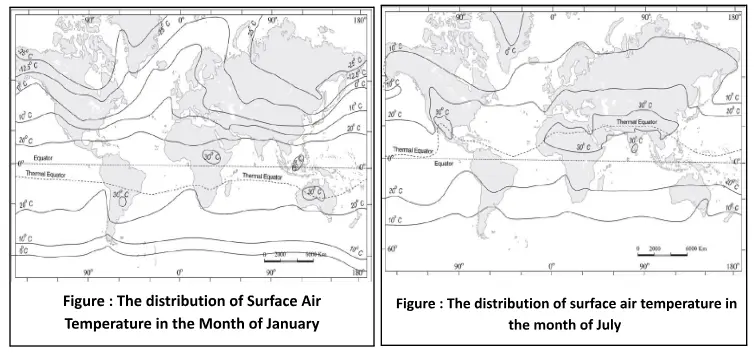
  • Isotherms: Isotherms are lines that connect places with the same temperature. 
    • They give us a visual representation of temperature distribution. 
    • Maps often use isotherms to depict temperature variations, especially for specific months like January and July.
  • Latitude’s Influence: Generally, isotherms tend to run parallel to latitudes. 
    • This means places at the same latitude often have similar temperatures. 
    • However, there are exceptions, especially in January in the northern hemisphere due to the vast landmass.
  • Land vs. Ocean Dynamics: The vast landmass in the northern hemisphere causes significant temperature deviations. 
    • For instance, warm ocean currents like the Gulf Stream push isotherms northward in the North Atlantic
    • But over continents, temperatures drop sharply, causing isotherms to bend southward, as seen in Europe and Siberia.
  • Temperature Range: In January , equatorial oceans are warm, with temperatures over 27°C. 
    • The tropics are over around 24°C, middle latitudes between 2°C and 0°C, and the chilly Eurasian interior plunges to between –18°C and –48°C. 
    • The southern hemisphere, with its oceanic dominance, sees more gradual temperature changes. 
    • The isotherm of 20° C, 10° C, and 0° C runs parallel to 35° S, 45° S and 60° S latitudes respectively. 
    • By July , isotherms in both hemispheres run more parallel to latitudes, with subtropical regions in Asia even crossing 30°C.

The distribution of Surface Air Temperature in the Month of January/The distribution of surface air temperature in the month of July

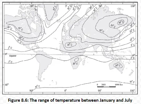
  • Temperature Extremes: Figure shows the difference in temperatures between January and July can be stark in some regions. 
    • North-eastern Eurasia experiences a massive range of over 60°C, attributed to its continental nature. 
    • Meanwhile, the region between 20° S and 15° N sees a minimal range of just 3°C.

The range of temperature between January and July

Temperature Inversion: Earth’s Reversed Altitude Dynamics

Temperature inversion is an atmospheric phenomenon that flips our usual understanding of how temperature behaves with altitude.

  • Normal lapse rate: Usually, as altitude increases, the temperature drops (6.5 °C per 1000 m), this decrease is known as the normal lapse rate
    • However, in certain conditions, this trend gets reversed, leading to what’s called a temperature inversion.
    • A long, clear winter night with the air standing still is an ideal condition for temperature inversion. 
    • As the night progresses, the Earth loses the heat that is absorbed during the day. 
    • By dawn, the ground becomes cooler than the air above it.
  • In polar regions, temperature inversion is normal throughout the year.

Plank’s law states that hotter a body, the more energy it will radiate and shorter the wavelength of that radiation.

Specific heat is the energy needed to raise the temperature of one gram of substance by one Celsius.

Effects of Surface Temperature Inversion: Isotherms and Atmospheric

Surface temperature inversions can have significant effects on the atmosphere and the environment, leading to phenomena like fog and frost protection in certain terrains. 

  • Stability of the Lower Atmosphere: Lower Layer Trap in Inversions
    • During a surface temperature inversion, the lower atmosphere becomes stable. 
    • This stability is due to a layer of warmer air being overlaid by a layer of cooler air near the Earth’s surface.
    • This stable condition traps smoke, dust, and other airborne particles beneath the inversion layer.
  • Airborne Particle Trapping: Effects of Atmospheric Inversions
    • Particles like smoke, dust, and pollutants are confined to the lower atmosphere and cannot rise through the inversion layer.
    • This results in the spread of these particles throughout the lower atmosphere.
  • Dense Fog Formation: Inversions and Winter Visibility
    • Surface temperature inversions are often associated with the formation of dense fog, especially on winter mornings.
    • Fog forms as the moisture in the trapped, cool air condenses, creating reduced visibility and high humidity at the surface.
  • Dispersal as the Sun Rises: Sun’s Rise and Air Mixing
    • With the arrival of daylight and solar heating, the inversion layer typically disperses.
    • As the Earth’s surface warms, the trapped cold air rises, mixing with the warmer air above.
  • Air Drainage in Hilly and Mountainous Terrains: Nocturnal Inversions and Valleys
    • In hilly and mountainous areas, surface temperature inversions can also occur due to a process called air drainage.
    • At night, cold air forms over the slopes of hills and mountains. 
    • This dense, cold air behaves like a liquid, flowing downward into valleys and low-lying areas.
    • Above this cold layer, warmer air remains.
  • Frost Protection: Frost Protection for Valleys
    • The downward flow of cold air, known as air drainage, acts as a protective shield for plants in valleys and low areas.
    • This downward movement of cold air can help protect plants from frost damage, as the cold air prevents the radiational cooling of the ground.

In summary, surface temperature inversions can lead to stable atmospheric conditions, the trapping of airborne particles, fog formation, and protective effects like frost protection in specific terrains. The dispersal of the inversion typically occurs as the sun rises and warms the Earth’s surface, promoting air mixing.

Glossary

  • Perihelion: It refers to the point in the orbit of a planet or other astronomical body, at which it is  closest to the sun.
  • Aphelion: It is the point at which an orbiting body is furthest from the sun.
  • Troposphere: It is the lowest layer of the Earth’s atmosphere in direct contact with the Earth’s surface.
  • Albedo: It is an expression of the ability of surfaces to reflect sunlight (heat from the sun).
  • Isotherms: Isotherms are lines that connect places with the same temperature.
  • Air Mass: It is a large body of air with generally uniform temperature and humidity.
  • Oceanic Currents: It is the movement of water from one location to another. 

Need help preparing for UPSC or State PSCs?

Connect with our experts to get free counselling & start preparing

THE MOST
LEARNING PLATFORM

Learn From India's Best Faculty

      
Quick Revise Now !
AVAILABLE FOR DOWNLOAD SOON
UDAAN PRELIMS WALLAH
Comprehensive coverage with a concise format
Integration of PYQ within the booklet
Designed as per recent trends of Prelims questions
हिंदी में भी उपलब्ध
Quick Revise Now !
UDAAN PRELIMS WALLAH
Comprehensive coverage with a concise format
Integration of PYQ within the booklet
Designed as per recent trends of Prelims questions
हिंदी में भी उपलब्ध

<div class="new-fform">


    </div>

    Subscribe our Newsletter
    Sign up now for our exclusive newsletter and be the first to know about our latest Initiatives, Quality Content, and much more.
    *Promise! We won't spam you.
    Yes! I want to Subscribe.