Win up to 100% Scholarship

Register Now

NCERT NOTES

Elevate your UPSC preparation with NCERT Notes – because every word matters on your journey to success.

Himalayan Drainage System: Analysis of Indus River and Its Tributaries

December 8, 2023 754 0

 Himalayan Drainage System: Origin, Nature, and Characteristics

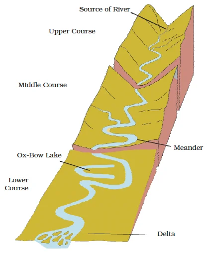
On the basis of the mode of origin, nature and characteristics, the Indian drainage may also be classified into the Himalayan drainage and the Peninsular drainage

Let us understand the Himalayan drainage system.
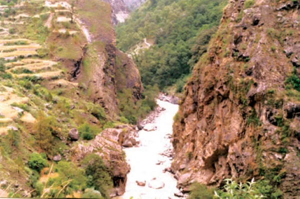
What are the Key Characteristics of the Himalayan Drainage System?

  • Dominant Basins and their significance of Himalayan Drainage System: The Himalayan drainage system primarily comprises the basins of three major rivers: the Ganga, the Indus, and the Brahmaputra.
  • Perennial Flow: The Lifeline of Himalayan Rivers: These rivers exhibit a perennial flow as they are nourished by both melting of snow and precipitation.
  • Erosional Features of Himalayan Rivers: Gorges and Uplift in the Himalayas: Their journey through the Himalayas is marked by the creation of gorges, carved out through the simultaneous processes of erosion and the Himalayan uplift (Refer Figure).
    • Alongside the deep gorges, these rivers also form V-shaped valleys, turbulent rapids, and waterfalls during their course through the mountainous terrain.

A Gorge

A Gorge

  • Transformation into Plains: Depositional Wonders Unfold:  As they transition into the plains, they undergo further transformations.
    • It resulted in depositional features like flat valleys, ox-bow lakes, flood plains, braided channels, and deltas formed near their respective river mouths.
  • River Course from Himalayas to Plains and Changing Drainage Pattern: In the Himalayan reaches, the course of these rivers is highly winding and tortuous.
    • But as they flow over the plains, they exhibit a pronounced tendency to meander and frequently shift their courses. 
    • River Kosi, also known as the ‘sorrow of Bihar’, has been notorious for frequently changing its course. 

Some features made by rivers

Some features made by rivers

Evolution of the Himalayan Drainage system through Shiwalik or Indo-Brahma:

  • River Shiwalik or Indo-Brahma debate: The evolution of the Himalayan rivers has been a subject of debate.
    • Geologists have put forward a theory that suggests a significant ancient river known as the Shiwalik or Indo-Brahma once flowed along the entire longitudinal extent of the Himalayas, stretching from Assam to Punjab and then onward to Sindh
    • Ancient River Discharge: A Journey into the Miocene Period: This massive river is believed to have discharged into the Gulf of Sind near lower Punjab during the Miocene period, which occurred approximately 5-24 million years ago.
    • Supporting Evidence: The Remarkable Continuity of Shiwalik and Its Deposits: Evidence supporting this theory includes the remarkable continuity of the Shiwalik and its deposits, which consist of sands, silt, clay, boulders, its lacustrine origin and alluvial nature.
  • Formation of Three Distinct Drainage Systems: Over time, it is postulated that the Indo-Brahma river underwent a process of dismemberment, resulting in the formation of three distinct drainage systems:
    • The Indus and its five tributaries in the western part;
    • The Ganga and its Himalayan tributaries in the central part; and
    • The Brahmaputra in Assam and its Himalayan tributaries in the eastern part.
  •  Role of Potwar Plateau: Geological Events in the Pleistocene Epoch: This dismemberment is thought to have occurred due to geological events during the Pleistocene epoch. 
    • The uplift of the Potwar Plateau (Delhi Ridge) in the western Himalayas is believed to have acted as a water divide, dividing the Indus and Ganga drainage systems.
  • Redirecting Ganga and Brahmaputra via the Malda Gap: Likewise, the mid-Pleistocene downthrusting of the Malda gap area, situated between the Rajmahal hills and the Meghalaya plateau, diverted the Ganga and Brahmaputra systems toward the Bay of Bengal.

The Indus River System within the Himalayan Drainage system: Size, Extent, and Geographic Significance

  • Size and Extent: Indus River Basin: The Indus River basin is one of the largest river basins of the world, encompassing an area of 11,65,000 square km, with 321,289 square km falling within the boundaries of India.
    • This river stretches over a total length of 2,880 km, of which 1,114 km are located in India.
  • Westernmost Himalayan River: Tracing the Course of Sindhu:  It is also known as the Sindhu, represents the westernmost of the Himalayan rivers in India.
  • Source of Indus: The Glacier near Bokhar Chu: The Indus River originates from a glacier near Bokhar Chu, located at approximately 31°15′ N latitude and 81°40′ E longitude, in the Tibetan region. The extensive Indus River basin is an integral part of the broader Himalayan drainage system.

Indus river system

Course of the Indus river and its Himalayan Drainage Connection

  • The Source in the Kailash Mountain Range: Singi Khamban’ and the Himalayan Connection:  Its source lies at an altitude of 4,164 meters within the Kailash Mountain range,  and is intricately connected to the Himalayan Drainage System. In the Tibetan region, it is referred to as ‘Singi Khamban’ or Lion’s mouth (In Tibet).
  • Journey through Jammu and Kashmir: Geographic and Hydrological Significance: This river’s remarkable journey through diverse landscapes is a significant aspect of the geography and hydrology of the region.
    • The Indus flows in India only through Jammu and Kashmir.
    • After commencing its journey in the northwest direction, situated between the Ladakh and Zanskar ranges.
    • It passes through regions like Ladakh and Baltistan.
  • Dramatic Gorge and Entry into Pakistan: Ladakh Range to Gilgit The river courses through the Ladakh range, forming a dramatic gorge near Gilgit in the union territory of Jammu and Kashmir, India.
    • Eventually, it crosses into Pakistan near Chilas, within the Dardistan region, marking a significant point of interaction with the Himalayan Drainage System on its journey towards the Arabian Sea.
  • Confluence with Panjnad and Southern Course: Merging with the Punjab Rivers: The river flows southward and receives ‘Panjnad’ a little above Mithankot. 
    • The Panjnad is the name given to the five rivers of Punjab, namely the Satluj, the Beas, the Ravi, the Chenab and the Jhelum.
  • Discharge into the Arabian Sea: The Culmination in Karachi:  It finally discharges into the Arabian Sea, east of Karachi. 

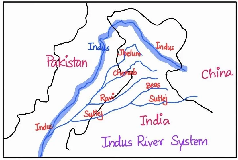
Do You know?

According to the regulations of the Indus Water Treaty (1960), India can use only 20 percent of the total water carried by the Indus river system. This water is used for irrigation in Punjab, Haryana and the southern and the western parts of Rajasthan

Himalayan Drainage: Tributaries of the Indus river system

  • The Indus River system, integral to the Himalayan drainage, is complemented by an array of significant tributaries, each with its unique origin and course.
  • Himalayan Tributaries and Confluence at Attock: It receives a number of Himalayan tributaries such as the Shyok, the Gilgit, the Zaskar, the Hunza, the Nubra, the Shigar, the Gasting and the Dras.
  • It finally emerges from the hills near Attock where it receives the Kabul river on its right bank.
  • Sulaiman Streams: Right Bank Tributaries Nourishing the Indus River: The other important tributaries joining the right bank of the Indus are the Khurram, the Tochi, the Gomal, and the Sangar
    • They all originate in the Sulaiman ranges.

Indus River

Left Bank Tributaries: Contributing Streams to the Indus River: Some of these are as below,

  • Jhelum: The Jhelum, a crucial tributary of the Indus, begins at a spring in Verinag, located at the southeastern part of the Kashmir Valley, near the foot of the Pir Panjal mountain range.
    • It traverses through Srinagar and the Wular Lake before crossing into Pakistan through a deep, narrow gorge.
    • Ultimately, it meets the Chenab near Jhang in Pakistan.
  • Chenab: The Chenab is the largest tributary of the Indus.
    • It is formed by the confluence of two streams, the Chandra and the Bhaga, near Tandi, situated close to Keylong in Himachal Pradesh. It is also referred to as Chandrabhaga.
    • This river flows for approximately 1,180 kilometers before entering Pakistan.
  • Ravi: The Ravi originates in the Kullu hills of Himachal Pradesh, west of the Rohtang Pass.
  • It flows through the Chamba valley before crossing into Pakistan, where it joins the Chenab near Sarai Sidhu.
  • During its course, the Ravi drains the region between the southeastern part of the Pir Panjal and the Dhauladhar ranges.
  • Beas: The Beas river is yet another important tributary originating from the Beas Kund near the Rohtang Pass, at an elevation of 4,000 meters above sea level.
    • It flows through the Kullu valley, forming gorges at Kati and Largi within the Dhauladhar range.
    • Upon entering the Punjab plains, it merges with the Satluj River near Harike.
  • Satluj: The Satluj River has its source in the ‘Raksas Tal’ near Mansarovar, Tibet, at an altitude of 4,555 meters. It is known as Langchen Khambab in Tibet.
    • The river flows nearly parallel to the Indus for around 400 kilometers before entering India.
    • It emerges from a gorge at Rupar, passes through the Shipki La in the Himalayan ranges, and subsequently enters the Punjab plains.

 Final Result – CIVIL SERVICES EXAMINATION, 2023.   Udaan-Prelims Wallah ( Static ) booklets 2024 released both in english and hindi : Download from Here!     Download UPSC Mains 2023 Question Papers PDF  Free Initiative links -1) Download Prahaar 3.0 for Mains Current Affairs PDF both in English and Hindi 2) Daily Main Answer Writing  , 3) Daily Current Affairs , Editorial Analysis and quiz ,  4) PDF Downloads  UPSC Prelims 2023 Trend Analysis cut-off and answer key

THE MOST
LEARNING PLATFORM

Learn From India's Best Faculty


 Final Result – CIVIL SERVICES EXAMINATION, 2023.   Udaan-Prelims Wallah ( Static ) booklets 2024 released both in english and hindi : Download from Here!     Download UPSC Mains 2023 Question Papers PDF  Free Initiative links -1) Download Prahaar 3.0 for Mains Current Affairs PDF both in English and Hindi 2) Daily Main Answer Writing  , 3) Daily Current Affairs , Editorial Analysis and quiz ,  4) PDF Downloads  UPSC Prelims 2023 Trend Analysis cut-off and answer key

Quick Revise Now !
AVAILABLE FOR DOWNLOAD SOON
UDAAN PRELIMS WALLAH
Comprehensive coverage with a concise format
Integration of PYQ within the booklet
Designed as per recent trends of Prelims questions
हिंदी में भी उपलब्ध
Quick Revise Now !
UDAAN PRELIMS WALLAH
Comprehensive coverage with a concise format
Integration of PYQ within the booklet
Designed as per recent trends of Prelims questions
हिंदी में भी उपलब्ध

<div class="new-fform">


    </div>

    Subscribe our Newsletter
    Sign up now for our exclusive newsletter and be the first to know about our latest Initiatives, Quality Content, and much more.
    *Promise! We won't spam you.
    Yes! I want to Subscribe.