NCERT NOTES

Elevate your UPSC preparation with NCERT Notes – because every word matters on your journey to success.

Inland Waterways: Commerce, Past, Potential, and Future

December 8, 2023 1430 0

Inland Waterways: Rise, Decline, and Modern Challenges

Rivers, canals, lakes and coastal areas have been important waterways since time immemorial. The development of inland waterways is dependent on the navigability width and depth of the  channel, continuity in the water flow, and transport technology in use. Rivers are the only means of transport in dense forests.

In ancient times, riverways were the main highways of transportation but they lost importance because of competition from railways, lack of water due to diversion for irrigation, and their poor maintenance.
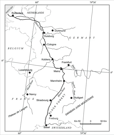
The following river waterways are some of the world’s important highways of commerce.

  • The Rhine Waterways: The Rhine flows through Germany and the Netherlands. 
    • It is navigable for 700 km from Rotterdam, at its mouth in the Netherlands to Basel in Switzerland. 
  • The Ruhr river joins the Rhine from the east. It flows through a rich coalfield and the whole basin has become a prosperous manufacturing area. 
    • This waterway is the world’s most heavily used. 
    • It connects the industrial areas of Switzerland, Germany, France, Belgium and the Netherlands with the North Atlantic Sea Route.
  • The Danube Waterway: This important inland waterways serves Eastern Europe. 
  • The Danube river rises in the Black Forest and flows eastwards through many countries. 
  • It is navigable up to Taurna Severin. The chief export items are wheat, maize, timber, and machinery.
  • The Volga Waterway: Russia has a large number of developed waterways, of which the Volga is one of the most important. 
    • It provides a navigable waterway of 11,200 km and drains into the Caspian Sea. 
    • The Volga-Moscow Canal connects it with the Moscow region and the Volga-Don Canal with the Black Sea. 
  • The Great Lakes – St. Lawrence Seaway: The Great Lakes of North America Superior, Huron Erie and Ontario are connected by Soo Canal and Welland Canal to form an inland waterways. 
  • The Mississippi Waterway: The Mississippi-Ohio waterway connects the interior part of the U.S.A. with the Gulf of Mexico in the south. 

Rhine Waterway

Rhine Waterway

Inland Waterways in India: Past Glory, Present Potential, Future Prospects

  • It was the chief mode of transport before the advent of railways. Diversion of river water for irrigation purposes made them non-navigable. 
  • Navigable Waterways in India: India has approximately 14,500 km of navigable waterways, contributing about 1 percent to the country’s transportation. 
    • It comprises rivers, canals, backwaters, creeks, etc. 
    • At present, 5,685 km of major rivers are navigable by mechanised flat bottom vessels. 
  • Inland Waterways Authority: For the development, maintenance and regulation of national waterways in the country, the Inland Waterways Authority was set up in 1986
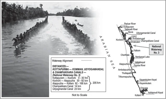
  • The backwaters (Kadal) of Kerala: These  have special significance in the Inland Waterways. 
    • Apart from providing cheap means of transport, they are also attracting a large number of tourists in Kerala. 
    • The famous Nehru Trophy Boat Race (Vallamkali) is also held in the backwaters.
  • The Untapped Potential of Waterways in India’s: Waterways are the cheapest mode of transport, being fuel-efficient and environment friendly. 
    • Though there are many rivers and canals in India, we still have a very limited number of operational waterway routes. 

National Waterway 3

National Waterway 3

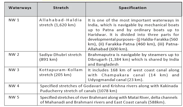
National Waterways Of India
National Waterways Of India

Coastal Shipping: Efficient Transport Along Vast Shorelines

  • While oceanic routes connect different countries, coastal shipping is a convenient mode of transportation with long coastlines, e.g. U.S.A, China and India. 
  • If properly developed, coastal shipping can reduce the congestion on the land routes.

Shipping Canals: Suez and Panama’s Impact on Global Trade  

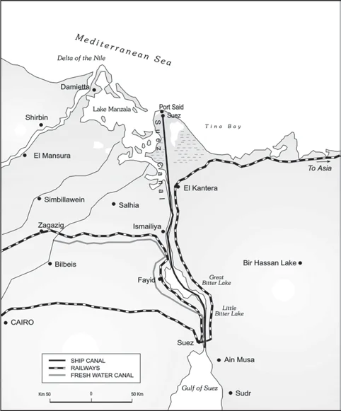
  • The Suez Canal: This canal was constructed in 1869 in Egypt between Port Said in the north and Port Suez in the south linking the Mediterranean Sea and the Red Sea. 
    • It gives Europe a new gateway to the Indian Ocean and reduces direct sea-route distance between Liverpool and Colombo compared to the Cape of Good Hope route. 
    • The tolls are very heavy here.(Refer figure)
  • The Panama Canal: This canal connects the Atlantic Ocean in the east to the Pacific Ocean in the west. 
    • It shortens the distance between New York and San Francisco by 13,000 km by sea.
    • The economic significance of this Canal is relatively less than that of the Suez
    • However, it is vital to the economies of Latin America. (Refer figure)

 Suez Canal

 Suez Canal

Alsor Read: Air Transport: Connecting Continents & Bridging Distances

Need help preparing for UPSC or State PSCs?

Connect with our experts to get free counselling & start preparing

THE MOST
LEARNING PLATFORM

Learn From India's Best Faculty

      
Quick Revise Now !
AVAILABLE FOR DOWNLOAD SOON
UDAAN PRELIMS WALLAH
Comprehensive coverage with a concise format
Integration of PYQ within the booklet
Designed as per recent trends of Prelims questions
हिंदी में भी उपलब्ध
Quick Revise Now !
UDAAN PRELIMS WALLAH
Comprehensive coverage with a concise format
Integration of PYQ within the booklet
Designed as per recent trends of Prelims questions
हिंदी में भी उपलब्ध

<div class="new-fform">


    </div>

    Subscribe our Newsletter
    Sign up now for our exclusive newsletter and be the first to know about our latest Initiatives, Quality Content, and much more.
    *Promise! We won't spam you.
    Yes! I want to Subscribe.