NCERT NOTES

Elevate your UPSC preparation with NCERT Notes – because every word matters on your journey to success.

Earthquakes: Causes, Impact, and Mitigation Strategies in India

June 21, 2024 5569 0

Earthquakes: Sudden Shaking, Destructive Forces, Varied Magnitude

Earthquake refers to the sudden shaking of the earth’s crust. It is highly destructive of all the natural disasters. They occur when there is a rupture in the Earth’s surface, typically along a fault line, leading to seismic waves that propagate through the ground. 

The intensity and magnitude of the temblor vary, causing shaking and trembling of the ground.

Do You Know ?

An earthquake with a magnitude 7.5 on the Richter scale releases 30 times the energy than one with 6.5 magnitudes. An earthquake of magnitude 3 is the smallest normally felt by humans.

Key points about earthquakes: Causes, Measurement, and Intensity Scales

  • Causes of Earthquakes:  Earthquakes result from a series of earth movements brought about by a sudden release of energy during the tectonic activities in the earth’s crust.
  • Earthquakes due to other causes: It could also be triggered by volcanic eruption, rock falls, landslides, subsidence, particularly in the mining areas, impounding of dams and reservoirs, etc. 

Do You Know ?

The largest earthquake that has been recorded with Richter Scale is 9.25 (Alaska, 1969 and Chile, 1960).

  • Measuring Earthquakes: Temblor can be measured by the use of two distinctively different scales of measurement demonstrating magnitude and
  • Richter Scale: Temblor magnitude is determined by the use of a seismograph, which is an instrument that continuously records ground vibration. 

List of Significant Earthquakes in India
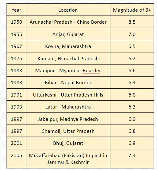
List of Significant Earthquakes in India

  • The scale was developed by a seismologist named Charles Richter, so-called the Richter Scale.
  • Mercalli Scale: The second type of scale, the temblor intensity scale measures the effects of a temblor where it occurs and was developed in 1902 by Mercalli, an Italian seismologist. 
    • Hence this scale is called the Mercalli scale.
  • Understanding Earthquake Intensity: Mercalli Scale expresses the intensity of a temblor effect on people, structure and the earth’s surface in values from I to XII.
    • Intensity of VI and below: People can feel the shake and there are cracks in the walls.
    • Intensity of XII: General panic with buildings collapsing totally and there is a total disruption in normal life.

Additional Information

  • The Indian plate is slowly moving northwards at a rate of one centimeter per year, encountering resistance from the Eurasian plate to the north. 
  • This ongoing pressure buildup eventually results in the sudden release of energy, leading to earthquakes along the Himalayan region. 
  • Areas most susceptible to these earthquakes include Jammu and Kashmir, Ladakh, Himachal Pradesh, Uttarakhand, Sikkim, Darjeeling in West Bengal, and all seven northeastern states.

Distribution Pattern of Earthquakes in India: Assessing Risk and Safety Levels

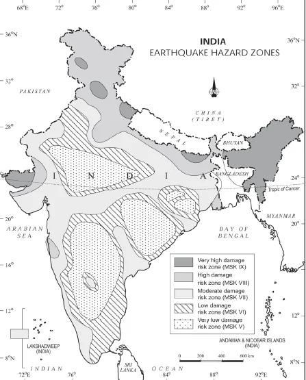
  • The seismic zoning map of India is divided into the following five temblor zones:
  1. Very high damage risk zone
  2. High damage risk zone
  3. Moderate damage risk zone
  4. Low damage risk zone
  5. Very low damage risk zone.
  • Very high damage risk zone: This zone includes,
    • North-east states, areas to the north of Darbhanga and Araria along the Indo-Nepal border in Bihar.
    • Uttarakhand, Western Himachal Pradesh (around Dharamshala) and Kashmir Valley in the Himalayan region and the Kachchh (Gujarat).

Do You Know ?

New Delhi  lie in very high damage risk zone whereas big cities like Mumbai and Chennai are in moderate damage risk zone.

  • High damage risk zone: This zone include, 
    • Parts of Jammu and Kashmir, Ladakh, Himachal Pradesh, Northern parts of Punjab, Eastern parts of Haryana, Delhi, Western Uttar Pradesh, and Northern Bihar. 
  • Moderate to Very Low Damage Risk Zone: Remaining parts of the country fall under moderate to very Low Damage Risk Zone
    • Most of the areas of the Deccan plateau are considered safe as far as temblor are concerned.

Earthquake Hazard Zones in India

Earthquake Hazard Zones in India

Consequences of Earthquakes: Impact on People, Infrastructure, and Environment

  • Terrifying Tremors: Temblor is often associated with fear and horror due to the scale, magnitude and suddenness at which it spreads disasters on the surface of the earth. 
    • It becomes a calamity when it strikes the areas of high density of population. 
  • Devastating Impact: It damages and destroys the settlements, infrastructure, transport and communication network, industries and other developmental activities.
    • It robs the population of the material and socio-cultural gains that they have preserved over generations. 
    • It renders people homeless, which puts pressure and stress, particularly on the weak economy of developing countries.
    • It also causes fires, dam failure and landslides which may block waterways and also cause flooding
  • Crippling Consequences: It may damage manufacturing industries and break down communication facilities. 
    • There is also a huge loss to the public health system, transport, communication and water supply in the affected areas.
  • Surface seismic waves produce fissures on the upper layers of the earth’s crust through which water and other volatile materials gush out, inundating the neighbouring areas. 

Earthquake Hazard Mitigation: Preparedness, Resilience, and Community Empowerment

  • Earthquake Preparedness: It is not possible to prevent the occurrence of a temblor. Hence, the next best option is to emphasise disaster preparedness and mitigation rather than curative measures such as:
    • Strengthening Earthquake Preparedness: Monitoring, Mapping, and Informing
      • Establishing temblor monitoring centres (seismological centres) for regular monitoring and fast dissemination of information among the people in the vulnerable areas. 
      • Use of Geographical Positioning System (GPS) can be of great help in monitoring the movement of tectonic plates.
      • Preparing a vulnerability map of the country and dissemination of vulnerability risk information among the people.
  • Disaster Resilience Strategies: Community Empowerment and Safer Construction
    • Empowering Communities: Educating people about the ways and means of minimising the adverse impacts of disasters.
    • Adaptive Architecture and Urban Planning: Modifying the house types and building designs in the vulnerable areas and discouraging the construction of highrise buildings, large industrial establishments and big urban centres in such areas.
      • Making it mandatory to adopt earthquake-resistant designs and use of light materials in major construction activities in vulnerable areas.
  • Essential Knowledge: Thus, Understanding temblors and their impact is vital for both scientific study and for implementing strategies to mitigate the damage caused by these natural disasters.
Must Read
Current Affairs Editorial Analysis
Upsc Notes  Upsc Blogs 
NCERT Notes  Free Main Answer Writing

Need help preparing for UPSC or State PSCs?

Connect with our experts to get free counselling & start preparing

Aiming for UPSC?

Download Our App

      
Quick Revise Now !
AVAILABLE FOR DOWNLOAD SOON
UDAAN PRELIMS WALLAH
Comprehensive coverage with a concise format
Integration of PYQ within the booklet
Designed as per recent trends of Prelims questions
हिंदी में भी उपलब्ध
Quick Revise Now !
UDAAN PRELIMS WALLAH
Comprehensive coverage with a concise format
Integration of PYQ within the booklet
Designed as per recent trends of Prelims questions
हिंदी में भी उपलब्ध

<div class="new-fform">


    </div>

    Subscribe our Newsletter
    Sign up now for our exclusive newsletter and be the first to know about our latest Initiatives, Quality Content, and much more.
    *Promise! We won't spam you.
    Yes! I want to Subscribe.