Udaan, Prahaar, Q&A Bank etc.
CA Magazines & Editorials
Explore the diverse physiography of India from the Himalayas to the Thar Desert, coastal plains to islands, and plateaus to plains covering all major physical divisions with maps and key facts.
Physiography of India: India stands as one of the world’s oldest and most advanced civilizations, boasting a unique cultural identity. It stretches from the snow-capped peaks of the Himalayas in the north to the sun-soaked coastal communities in the south, with lush tropical forests lining the southwestern coastline. The eastern part features the verdant Brahmaputra river, while the western region encounters the expansive Thar Desert.
The Indian mainland’s longitude ranges between 8°4′ and 37°6′ north, while its latitude spans from 68°7′ East to 97°25′ East. This configuration results in a longitudinal extension of 2933 km from east to west and a latitudinal stretch of 3214 km from north to south.
At a latitude of 23°30′ north, the Tropic of Cancer neatly divides India into two equal halves – Northern India and Southern India. Along this significant circle of latitude lie the states of Gujarat, Rajasthan, Madhya Pradesh, Chhattisgarh, Jharkhand, West Bengal, Tripura, and Mizoram.
The western and eastern extremities of the country differ by approximately two hours due to a 30-degree variance in longitude. Positioned at 82°30′ East, the Standard Meridian lies at the heart of the nation. The Indian Standard Time is set here, which is 5 and a half hours ahead of GMT. This Meridian’s trajectory runs through Mirzapur in Uttar Pradesh, near Allahabad.
Physiography refers to the physical geography or the natural features and characteristics of a land or region. It involves the study and description of the physical aspects of the Earth’s surface, including landforms, terrain, climate, vegetation, and water bodies. Physiography provides insight into the natural landscape and how it has been shaped over time by geological, hydrological, and atmospheric processes.
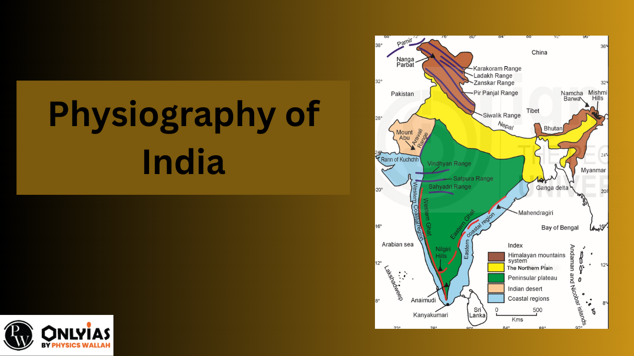
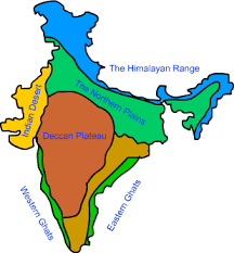
ndia is a country with a wide range of physical features. These features have led to the classification of India into six distinct physiographic divisions, each characterized by its own unique geographical characteristics.
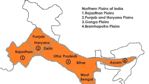
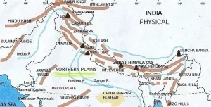
The Indus, Ganga, and Brahmaputra rivers have carried and deposited alluvial materials that formed them. Spanning 3200 km from east to west in Indian Physiography, the Northern Plains hold a prominent place. Remarkably, the alluvial deposits can be found up to 2000 kilometres beneath the surface.
In this region, there’s a sequence of geographical features:
Within the alluvial plains, there are two divisions:
These divisions showcase the gradual transition from the foothills to the flat plains, each with its own distinct characteristics and geographical significance.
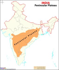
The biggest natural land area in India is the Peninsular Upland. It’s like a lopsided triangle and mostly sits between 600 to 900 meters above the ocean level. The outside borders of this Peninsular plateau are marked by the Delhi Ridge in the northwest (kind of an extension of the Aravallis), the Raj Mahal Hills in the east, the Gir Range to the west, and the Cardamom Hills in the south. The Shillong and Karbi-Anglong plateau are a continuation towards the northeast.
The Peninsular plateau is a part of India’s oldest and most steady landmass, shaped by the breaking and shifting of the Gondwana landmass. Its structure is made up of old crystalline, igneous, and metamorphic rocks.
Peninsular India is formed of several plateaus, like the Hazaribagh, Palamu, Ranchi, Malwa, Coimbatore, and Karnataka plateaus. This region has gone through phases of rising and sinking, along with cracks and fractures in the Earth’s crust. This has caused the landscape of the Peninsular Plateau to change. In the northwest of the plateau, there are rugged terrains with canyons and deep valleys. The three main valleys are Chambal, Bhind, and Morena.
One distinctive feature of the Peninsular Plateau is the Deccan Trap, an area with dark soil. The rocks in these regions are igneous because they came from volcanic activity. Over time, these rocks have worn down to create the black soil.
The Peninsular Plateau can be divided into three main parts based on its landscape:
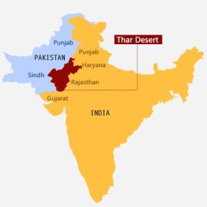
A desert can be defined as a dry area where more water is lost through evaporation than gained through precipitation. Rajasthan is the location of more than 60% of the Thar Desert, which is often referred to as the Great Indian Desert. Some key facts about this desert are as follows:
The Thar Desert, also known as the Great Indian Desert, is situated to the northwest of the Aravalli Hills. It consists of a rolling landscape with long, crescent-shaped dunes called longitudinal barchans, as well as scattered individual dunes.
The region receives very limited rainfall, generally less than 150 mm per year. This results in a dry climate and sparse vegetation. It’s often called Marusthali due to these unique characteristics.
During the Mesozoic era, it’s believed that this area was once underwater. Evidence for this can be found in the Akal’s wood fossils park and sea deposits near Brahmsar, both located close to Jaisalmer. These wood fossils are estimated to be around 180 million years old on average.
While the desert’s surface features have been shaped by weathering processes and the effects of wind, its underlying rock structure is connected to the Peninsular Plateau.
The Thar Desert showcases distinct geographical features such as mushroom rocks, oases, and shifting sand dunes.
Geographically, the desert can be divided into two halves based on its orientation: the southern part faces the Rann of Kachchh, while the northern part slopes toward Sindh.
The Luni River is the primary significant river that flows through the southern portion of the desert, reaching the Arabian Sea through the Rann of Kutch. In the desert, there are certain water bodies that temporarily flow before eventually drying up and joining a lake or playa. This illustrates a common phenomenon of inland drainage. The main source of salt in the area comes from the brackish water present in these lakes and playas.
India’s landscape includes two significant groups of islands situated in the Arabian Sea and the Bay of Bengal. The Andaman and Nicobar Islands group, located in the Bay of Bengal, consists of a total of 204 islands. These islands are separated by the “Ten Degree Channel,” with the Andaman Islands to the north and the Nicobar Islands to the south. These island coastlines are marked by picturesque coral reefs and beautiful beaches. The vegetation on these islands is of the equatorial type. In the Arabian Sea, the Lakshadweep and Minicoy Islands are part of another island group. These islands are situated not far from the Malabar Coast and are entirely formed from coral deposits. Among these islands, Minicoy is the largest of the 43 islands.
Regarding the Bay of Bengal island groups, there are approximately 572 islands and islets located between latitudes 6°N and 14°N and longitudes 92°E and 94°E. The two main islet groups are the Ritchie’s archipelago and Labyrinth Island. The entire group of islands can be divided into the Andaman Islands in the north and the Nicobar Islands in the south, separated by the 10° channel.
Moving on to the islands in the Arabian Sea, the Lakshadweep and Minicoy islands are spread between latitudes 8°N and 12°N and longitudes 71°E and 74°E. These islands are situated about 280 to 480 kilometers away from the coast of Kerala. The entire chain of islands is composed of coral deposits. Among the 36 islands, 11 are inhabited. The largest among them, Minicoy, covers an area of 453 square kilometers. The 11° channel serves as a rough division for the entire collection of islands, with Amini Island to the north and Canannore Island to the south.
The extensive Himalayas primarily run in a northwest to southwest direction, particularly in the Northwestern region. However, in certain areas like Nagaland, Manipur, and Mizoram, they are oriented from north to south. The Himalayas play a significant role as a geographical, climatic, hydrological, and cultural divider. Let’s explore the subdivisions of the Himalayas:
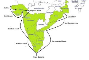
The coastal plains of India are flanked by the Arabian Sea and the Bay of Bengal, both of which run alongside the country. These coastal plains are divided into Western and Eastern Coastal Plains based on their location and ongoing geological processes.
The Western Coastal Plain spans from the Rann of Kachchh to Kanyakumari and can be further categorized into four distinct sections:
While the western coast widens as it moves towards the northern and southern ends, it remains narrower in its central portion. Unlike the rivers on the Western Coast, those on the Eastern Coast do not form deltas.
On the other hand, the Eastern Coastal Plain extends along the Bay of Bengal. It is relatively narrower than its western counterpart and is characterized by its developing nature, leading to a limited number of ports and harbours. Notably, well-established deltas are formed by the Mahanadi, Godavari, Krishna, and Kaveri rivers in this region. The continental shelf extends up to 500 kilometers into the sea from the coast.
Physical Features of India in Map
| Related Links | |
|---|---|
| Districts of UP List | National Emblem of India |
Check Out UPSC CSE Books
Visit PW Store
Explore SRIJAN Program

The major mountain ranges in India include the Himalayas, Western Ghats, Eastern Ghats, Aravalli Range, and Vindhya Range. The Himalayas, in particular, are the world's highest and youngest mountain range, stretching across northern India.
Rivers are a significant part of India's physiography, shaping the landscape and providing water resources for various activities. Major rivers like the Ganges, Yamuna, Brahmaputra, and Indus have shaped plains and valleys and support agriculture and livelihoods.
The Thar Desert, also known as the Great Indian Desert, is the most prominent desert in India. It covers parts of Rajasthan and plays a vital role in the country's landscape by highlighting the diversity of terrain and climate.
The Western Ghats and Eastern Ghats are mountain ranges that run parallel to the western and eastern coasts of India, respectively. They are important biodiversity hotspots, home to diverse flora and fauna, and influence regional climate patterns.
The physiography of India refers to the study of the physical features, landforms, and terrain characteristics that make up the country's geographical landscape. It encompasses mountains, plateaus, plains, valleys, rivers, deserts, coasts, and islands.


Explore UPSC Foundation Batches

Connect with our experts to get free counselling & start preparing
Join India’s trusted platform for expert guidance, quality content, proven success.
Learn anytime, anywhere.


India's leading UPSC coaching platform helping aspirants prepare for IAS, IPS, IFS and other Civil Services examinations with the best faculty and proven strategies.
<div class="new-fform">
</div>