Books

The Tapi River, also known as the Tapti River, is a major west-flowing River in central India. It originates in Madhya Pradesh, flows through Maharashtra and Gujarat, and empties into the Arabian Sea. The Tapi River system is vital for irrigation and industry in its basin, characterized by fertile black soils.
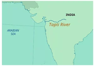
Tapi River, also called the Tapti River, is a major west-flowing River of central India. It originates from the Satpura Range in Madhya Pradesh, flows through Maharashtra and Gujarat, and finally drains into the Arabian Sea near Surat through the Gulf of Khambhat.
The Tapi River basin covers about 65,000 sq km and has fertile black soils and wide Tapi River flood plains, which support farming and settlements. Important tributaries, dams like Ukai, and irrigation projects make the River vital for agriculture, industries, and geography studies.
Explore Degree Courses

Explore Degree Courses
The Tapi River is one of the major Rivers of India that flows from east to west. It is also known as the Tapti River. This River and Tapi River map is very important for geography students because it is among the few Rivers that flow westward in India.
The Tapi River origin and course explain why this River is unique in Indian geography. The Tapi River is well known for its westward flow and rift valley path.
The Tapi River basin is an important physical region in western India. It supports forests, farms, and settlements across areas drained by the Tapi River.
The Tapi River has 14 major tributaries, each over 50 kilometers long. The left bank tributaries form a larger drainage system.
| Tapi River Tributaries | ||
|---|---|---|
| Bank | Major Tributaries | Key Points |
| Left Bank | Purna, Girna, Panjhara, Bori, Waghur, Amravati, Buray, Nesu, Mona, Sipna | Purna is the largest tributary, with perennial flow. |
| Right Bank | Vaki, Aner, Arunawati, Gomai | Originate in the Satpura ranges. |
The Tapi River estuary is located near Surat in Gujarat, where the Tapi River meets the Gulf of Khambhat in the Arabian Sea. This west-flowing River, with a length of about 724 km, forms an estuary instead of a delta, which is rare in India.
The estuary is strongly affected by tides and supports mangroves, rich plant life, and many freshwater and marine animals. Because of its high tidal range and mixed water, the Tapi River estuary is a highly productive and important natural ecosystem.
The soil types in the Tapi River basin support rich farming activities. These soils play a major role in crop growth across areas covered by the Tapi River.
The Tapi River supports many major projects and industries across its basin. These Tapi River irrigation projects and industries play a key role in power generation, farming, and regional growth.
Check Out UPSC CSE Books
Visit PW Store
The Tapi River flow direction is an important feature in Indian geography. The Tapi River flows westward, which makes it different from most peninsular Rivers of India.
The Tapi River and its basin are agriculturally rich. The fertile black soils support diverse crops. Cotton, sugarcane, groundnut, and millets are common. Irrigation from projects like Ukai Dam and Hatnur Dam enhances productivity. These Tapi River irrigation projects make the valley a vital economic zone.
Ready to boost your UPSC preparation? Join PW’s UPSC online courses today!
Explore UPSC Test Series

The Tapi River originates at Multai in the Betul district of Madhya Pradesh, within the Satpura Range.
The Tapi River flows through Madhya Pradesh, Maharashtra, and Gujarat.
It flows parallel to the Narmada River in a west-flowing rift valley and shares similar length and basin features.
The basin primarily consists of black soils, with alluvial clays and black soil layers found in Gujarat's coastal plains.
The Ukai Dam, located in Gujarat, is a significant project on the Tapi River, providing irrigation and hydropower.


Explore SRIJAN Prelims Crash Course

Connect with our experts to get free counselling & start preparing
Books
Udaan (Prelims Wallah)
Prahaar (Mains Wallah)
Q&A Bank (Prelims & Mains)
Budget & Economic Survey
NCERT Wallah
Marks Booster
हिंदी माध्यम विशेष शृंखला
 Current Affairs
Monthly Current Wallah
Subject Wise Current Affairs
Editorial Analysis
Editorial PDFs
News of The Day
Download Our App


Download Our App
<div class="new-fform">
</div>
 GS Foundation
 Optional Course
 Combo Courses
 Degree Program