Drainage Patterns: Nature’s Geometric Designs

May 4, 2024 537 0

Drainage patterns offer insights into a region’s geological history, revealing how rocks and landscapes have evolved over time. By examining drainage patterns, we can map the underlying geology and topography of an area and also understand the impact of natural and human factors on the landscape’s formation. Understanding these dynamics is crucial for predicting future changes and managing natural resources effectively.

Various Drainage Patterns and Their Impact on Landscape Development

Dendritic Drainage Pattern: Resembles the branches of a tree; develops in region with uniform lithology, 
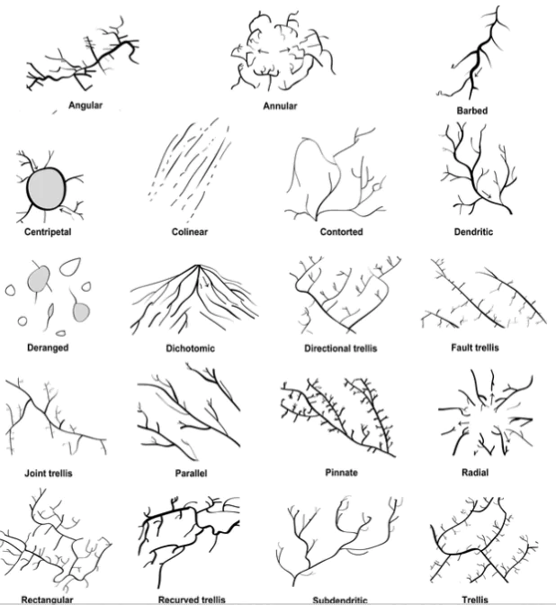
  • Trellis Drainage Pattern: Short streams meet the main stream at right angles, differential erosion through soft rocks, 
    • Example: Singhbhum, Seine basin (France).
  • Angular Drainage Pattern: Tributaries join the main stream at acute angles, common in Himalayan foothills.
  • drainage patterns Rectangular Drainage Pattern: Main stream and tributaries join at right angles, formed in regions with faulting, 
    • Example: Colorado River (USA), Vindhyan Mountains (India).
  • Radial Drainage Pattern: Tributaries from summit drain in all directions, originate from a central point, 
    • Example: Amarkantak Hills, Girnar Hills.
  • Centripetal Drainage Pattern: Streams from all sides converge in a low-lying basin, low-lying central depression, 
    • Example:  Streams of Ladakh, Tibet, Baghmati (Nepal).
  • Deranged Drainage Pattern: Uncoordinated pattern in ice-sheet vacated regions, found in glaciated valleys, 
    • Example: Karakoram glaciated valleys.
  • Barbed Drainage Pattern: Tributaries meet the main river discordantly; tributaries flow in opposite direction to their master streams, 
    • Example: Arun River (Nepal), Kosi tributary.
  • Annular Drainage Pattern: Circular path around summit with subsequent tributaries, rare in India, 
    • Example: Pithoragarh, Nilgiri Hills (India).
  • Parallel Drainage Pattern: Tributaries run parallel in a uniformly sloping region, 
    • Example: Rivers of Western Coastal plains.

Enroll now for UPSC Online Course

Must Read
Current Affairs Editorial Analysis
Upsc Notes  Upsc Blogs 
NCERT Notes  Free Main Answer Writing

Conclusion

In the complicated web of rivers and streams, nature creates beautiful designs with different drainage patterns. Some look organized, while others seem random. Each pattern shows how the land was formed by things like rocks and weather. By looking at these patterns, we can learn about the history of the earth and how it’s still changing today.

Related Articles 
Drainage Systems: Nature’s Blueprint for Water Movement Northern Plains of India Importance, Features, Maps And States
River Systems of India: Brahmaputra and Peninsular Drainage Overview Indian Weather Seasons: Understanding the Annual Climate Cycle


THE MOST
LEARNING PLATFORM

Learn From India's Best Faculty

      
Quick Revise Now !
AVAILABLE FOR DOWNLOAD SOON
UDAAN PRELIMS WALLAH
Comprehensive coverage with a concise format
Integration of PYQ within the booklet
Designed as per recent trends of Prelims questions
हिंदी में भी उपलब्ध
Quick Revise Now !
UDAAN PRELIMS WALLAH
Comprehensive coverage with a concise format
Integration of PYQ within the booklet
Designed as per recent trends of Prelims questions
हिंदी में भी उपलब्ध

<div class="new-fform">


    </div>

    Subscribe our Newsletter
    Sign up now for our exclusive newsletter and be the first to know about our latest Initiatives, Quality Content, and much more.
    *Promise! We won't spam you.
    Yes! I want to Subscribe.