Erosional Landforms by Running Water: Valleys, Gorges, Canyons

June 1, 2024 2370 0

Introduction

Running water, especially in rainy areas, is a strong force that shapes the land. It flows over the ground in sheets, streams, and rivers. Over the years, it forms different kinds of land features, like valleys when it’s young, wide floodplains when it’s grown up, and curvy meanders when it’s older. One can see how running water changes the land all around us, from the start of a river to where it meets the sea.
The Evolution of Landforms by Running Water

  • Humid Regions: It is an important geomorphic agent in humid regions with heavy rainfall. 
    • It has 2 components:  Overland Flow or Sheet and Linear flow occurs as streams and rivers in valleys.
  • Landforms: These are formed due to running water and develop in 3 stages: Youth, Mature and Old
  • Features of Youth Stage: V-shaped valleys, gorges due to vertical erosion;  river capture with headward erosion; waterfalls, rapids, Cataractsand Interlocking spurs.
  • Features of the Mature Stage: Valley widening due to lateral erosion; flood plains; Meanders, Incised Meanders, Terraces, Point bars, River cliffs and Slip off slopes. 
  • Features of the Old Stage: Extensive flood plains; Meanders and Oxbow lakes; Braided streams, Levees, Point bars, cliffs and Deltas
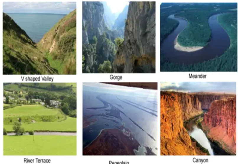
  • Peneplain and Monadnocks: Over time, stream erosion can create plains called Peneplain, in which some sturdy rock remnants, known as Monadnocks, can be seen. 

Enroll now for UPSC Online Course

Erosional Landforms Formed by Running Water (Fluvial Landforms) 

Running Water

  • Valleys: Its evolution starts from narrow rills to long, wide gullies and eventually to valleys. Various types of valleys, such as V-shaped valleys, Gorges, and Canyons, may form depending on rock type and structure. 
  • Gorges: These landforms have steep sides and are equal in width at the top and bottom, and they are formed in hard rocks. 
  • Canyons: exhibit steep, step-like slopes and tend to be wider at the top than at the bottom; they are formed in horizontally bedded sedimentary rocks; found in dry areas. 
    • Example: Grand Canyon
  • Potholes and Plunge Pools:  Potholes are circular depressions formed on rocky streambeds due to erosion and the abrasion of rock fragments; 
    • Pebbles and boulders get collected in these holes, and rotated and making the depression wider and deeper.
  • Plunge pools form at the base of waterfalls due to the force of the water and soft rocks.
  • Incised or Entrenched Meanders: Loop-like channels are called meanders. Water changes its course due to low kinetic energy
    • Streams flowing over gentle slopes develop meandering courses because of active lateral erosion; 
    • It is common to find meandering courses  in floodplains and delta plains
  • Entrenched Meanders: It is a deep, wide meander in a river or stream that has cut down into hard rock.
    • They are formed when a river cuts quickly, which reduces the opportunity for lateral erosion and results in symmetrical slopes.
    • They can be found in hard rock and can widen and deepen over time to form deep gorges or canyons.
    • Some meanders develop loops which later on are converted into oxbow lakes.
  • Reasons for the formation of meanders: Gentle gradient; Coriolis force; & irregularities along the river banks.
  • Running WaterRiver terraces: River terraces are surfaces marking old valley floors or floodplain levels. They result from vertical erosion by the stream into its own depositional plain.
    • Terraces are the result of receding water after a peak flow,
    • Changes in hydrological regime due to climatic changes, 
    • Tectonic uplift of the land, and sea level changes in the case of rivers closer to the sea.
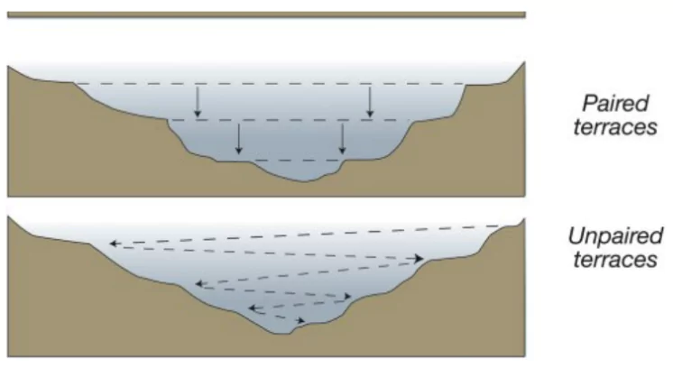
  • Paired Terraces: Occur at the same elevation on either side of the rivers. 
  • Unpaired Terraces: Terraces present at one side only or present at different elevations. They are typical in areas of slow uplift of land or where the water column changes are not uniform along both banks.
  • River Valleys
    • Youth Stage: V-shaped valleys with steep sides; 
    • Mature Stage: Broad valleys, flat floors, meandering channels; 
    • Old Stage: Shallow valleys with gentle slopes.
  • Rapids: Fast-flowing, turbulent water with abrupt elevation changes; typically found in steep or mountainous river sections.
Must Read
Current Affairs Editorial Analysis
Upsc Notes  Upsc Blogs 
NCERT Notes  Free Main Answer Writing

Conclusion

  • Running water shapes the Earth’s surface by eroding and forming different landforms. From majestic canyons to peaceful floodplains, these features give us valuable insights into how our planet changes. As a powerful force in shaping landscapes, running water continuously molds the terrain, creating captivating scenery and inspiring exploration.
Related Articles 
The Ganga River System Continental Drift Theory
Earthquakes: Forces, Causes, and Protective Measures 7 Continents and 5 Oceans in Order of the World


THE MOST
LEARNING PLATFORM

Learn From India's Best Faculty

      
Quick Revise Now !
AVAILABLE FOR DOWNLOAD SOON
UDAAN PRELIMS WALLAH
Comprehensive coverage with a concise format
Integration of PYQ within the booklet
Designed as per recent trends of Prelims questions
हिंदी में भी उपलब्ध
Quick Revise Now !
UDAAN PRELIMS WALLAH
Comprehensive coverage with a concise format
Integration of PYQ within the booklet
Designed as per recent trends of Prelims questions
हिंदी में भी उपलब्ध

<div class="new-fform">


    </div>

    Subscribe our Newsletter
    Sign up now for our exclusive newsletter and be the first to know about our latest Initiatives, Quality Content, and much more.
    *Promise! We won't spam you.
    Yes! I want to Subscribe.