Books

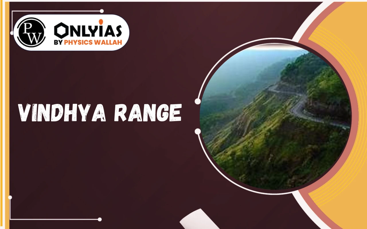
Vindhya Range, a central Indian hill system, forms a natural boundary between North India and the Deccan Plateau. Stretching about 1,200 km across Gujarat, Madhya Pradesh, Uttar Pradesh, and Bihar, it features ancient sedimentary rocks, flat-topped hills, major rivers like Narmada and Son, dry deciduous forests, and diverse wildlife, including tigers and leopards.
Explore Vindhya Range of central India. Learn its location, origin, geology, rivers, highest peak, biodiversity, and role as a natural boundary between North India and the Deccan Plateau.
The Vindhya mountain range, located in central India, serves as an important natural boundary. It marks the separation between North India and the Deccan Plateau, effectively dividing the Indo-Gangetic plains from the southern plateau region.
Historically and geographically, this range has played a key role in distinguishing the northern and southern parts of the country. Read on to learn about Vindhya range location, origin and geology, length and extent, and much more
What is the Vindhya Range?
The Vindhya Range is a discontinuous chain of hills and plateaus in west-central India. It stretches across several states, acting as a significant geographical barrier. It forms a traditional boundary, especially prominent for understanding the Vindhya range between north and south India.
Vindhya Range Origin and Geology
The Vindhya range origin and geology are very important for exams. These mountains are ancient, primarily made up of sedimentary rocks such as sandstone, limestone, and shale. Geologists classify their structure as the Vindhyan Supergroup, which dates back to the Proterozoic era, making these rocks over a billion years old.
Unlike the folded Himalayas, the Vindhyas are block mountains formed by faulting. The Vindhya range natural resources include limestone, sandstone, and other deposits, many of which are used in industries like cement production.
Its terrain features flat-topped hills and a plateau-like structure, linking the plains of northern India with the Deccan Plateau to the south. The region is also known for its flat-topped hills and plateau-like structure.
This connects directly to the Vindhya range plateau region, which forms a transition between plains and the Deccan plateau.

Vindhya Range Length and Extent
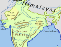
The Vindhya range length and extent cover a wide area of central India. The range extends for about 1200 kilometers. It begins near Gujarat and stretches through Madhya Pradesh to Uttar Pradesh and Bihar.
The Vindhya range states include:
Some parts also influence Chhattisgarh and run almost parallel to the Satpura range in many areas. The range is not very high compared to the Himalayas. But its geographical importance is huge.
Check Out UPSC CSE Books
Vindhya Range Highest Peak and Elevation
The highest point in the Vindhya Range is Sad-bhawna Shikhar, also called Kalumar Peak. It rises to 752 metres above sea level and is located in the Panna or Bhander hills of Madhya Pradesh.
Generally, the Vindhya Range does not exceed 700 metres in height, making it lower than the Satpura Range. This difference in elevation is an important point when comparing the Vindhya and Satpura ranges.
The Vindhya range passes are important for transport and trade. One famous pass is near Asirgarh. It connects northern India with the Deccan region. Historically, armies used these passes to move between regions.
The northern slopes of the Vindhya Range feed tributaries of the Ganga-Yamuna river system, including the Chambal, Betwa, Ken, and Son rivers. On the southern side, the range is drained by rivers such as the Narmada, which flows west into the Arabian Sea, and the Son, which joins the Ganga.
Acting as a major watershed, the Vindhyas separate rivers that flow northward from those that drain southward. This drainage pattern makes the Vindhya range plateau region agriculturally important in some parts, as river valleys are fertile and support settlements.
The Vindhya range climate is mostly tropical. Summers are hot. Winters are mild. Rainfall depends on the monsoon.
The western parts receive moderate rainfall. The eastern parts receive slightly more rainfall. Forest cover varies from dry deciduous to mixed forests.
The vegetation consists mainly of tropical dry deciduous forests. Common trees include teak, sal, and bamboo. These trees shed leaves in dry seasons to save water.
The Vindhya Range in central India has a rich biodiversity, with forests dominated by dry deciduous trees such as teak, bamboo, and sal in the eastern areas.
The region is home to large predators like Bengal tigers, Indian leopards, and sloth bears, while herbivores include spotted deer and blackbuck. Smaller mammals, including Indian wild dogs, also inhabit the area, and the river valleys provide important routes for migratory birds.
The plateau-like terrain creates diverse habitats, supporting a variety of plant and animal species. Although its biodiversity is not as dense as that of the Western Ghats, the Vindhya Range remains ecologically significant.
If you are preparing for UPSC or State PCS, master topics like the Vindhya mountain range, its map, geology, rivers, and differences from the Satpura range. ExplorePW OnlyIAS Courses today and strengthen your preparation!

The Vindhya Range is located in central India. It stretches across Gujarat, Madhya Pradesh, Uttar Pradesh, and Bihar.
The highest peak is Sad-bhawna Shikhar, also known as Kalumar Peak. It stands at 752 metres in Madhya Pradesh.
Key rivers include the Narmada, Son, Chambal, Betwa, and Ken. These rivers drain different sides of the range.
The Vindhya Range lies north of the Narmada River. The Satpura Range is located south of the Narmada. The Narmada River flows in a rift valley between them.


Connect with our experts to get free counselling & start preparing
Books
Udaan (Prelims Wallah)
Prahaar (Mains Wallah)
Q&A Bank (Prelims & Mains)
Budget & Economic Survey
NCERT Wallah
Marks Booster
हिंदी माध्यम विशेष शृंखला
 Current Affairs
Monthly Current Wallah
Subject Wise Current Affairs
Editorial Analysis
Editorial PDFs
News of The Day
Download Our App


Download Our App
<div class="new-fform">
</div>


 GS Foundation
 Optional Course
 Combo Courses
 Degree Program