Explore Our Affordable Courses

Click Here

The Ganga River System: Course, Tributaries, and Significance

May 4, 2024 2949 0

Introduction

The Ganga river has a length of 2,525 km. It is shared by Uttarakhand (110 km) and Uttar Pradesh (1,450 km), Bihar (445 km) and West Bengal (520 km). Ganga basin covers the states of Uttar Pradesh, Madhya Pradesh, Rajasthan, Bihar, West Bengal, Uttarakhand, Jharkhand, Haryana, Chhattisgarh, Himachal Pradesh and Union Territory of Delhi draining nearly 26% of the total geographical area of the country.
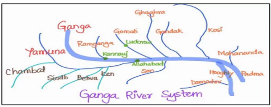
Course of the Ganga River

  • Source: Originates as Bhagirathi from Gangotri Glacier.
    • Alaknanda: originates from the Satopanth glacier, located above Badrinath. It is formed by the convergence of the Dhauli and the Vishnu Ganga at Joshimath (Vishnu Prayag); Mandakini (Origin: Chorabari glacier) is a tributary of Alaknanda.
    • Karnaprayag: Pindar River meets Alaknanada.
  • Dev Prayag: Alaknanda and Bhagirathi meet at Dev Prayag. From where it is known as Ganga.
  • At Haridwar: Ganga emerges from the mountains onto the plains.
    • It splits into two distributaries, namely the Bhagirathi and the Padma near the mouth.
  • Discharge Point: It discharges itself into the Bay of Bengal near the Sagar Island.
  • Farakka: in West Bengal is the northernmost point of Ganga delta.
  • Ambala: is located on the water divide between the Indus and the Ganga river systems.

Enroll now for UPSC Online Course

Tributaries of the River Ganga

Left Bank Tributaries of Ganga

  • Gandak
    • Comprises two streams – Kaligandak and Trishulganga.
    • Ganga River Origin: Nepal Himalayas between the Dhaulagiri and Mount Everest and drains the central part of Nepal. 
    • Enters Ganga plain in Champaran (Bihar); joins Ganga near Patna.
    • Kanwar lake (Ox Bow lake) is fed by the river. [UPSC 2023]
  • Ghaghara
    • Origin: Glaciers of Mapchachungo (Gurala Mandhata peak); Emerging from the mountains, it creates a deep gorge at Shishapani.
    • Tributaries: Tila, Seti, and  Beri
    • Sarda (Kali or Kali Ganga) joins it before it finally meets Ganga at Chhapra.
    • Sarayu is the largest tributary of the Sharda River. Ayodhya is situated on Sarayu river.
  • Kosi
    • It  is an antecedent river
    • Origin: North of Mount Everest in Tibet where its main stream Arun rises
    • Joined by Son Kosi (West) and Tamur Kosi (East) after crossing the Central Himalayas in Nepal; forms Sapt Kosi after uniting with Arun.
  • Ramganga: Origin is Garhwal hills; joins Ganga near Kannauj.
  • Sarda or Saryu: Origin is Milam glacier in the Nepal Himalayas where it is known as Goriganga. Along the India-Nepal border, it is known as Kali or Chauk and eventually joins the Ghaghara River.
  • Mahananda: Origin is in Darjeeling hills; final left bank tributary of the Ganga which joins it in West Bengal.

Right Bank Tributaries of Ganga

A. Yamuna

    • Westernmost and longest tributary of the Ganga; Joins Ganga at Prayag (Allahabad)
    • Origin: Yamunotri glacier near Bandarpoonch peaks in the Mussoorie range.
  • Tributaries: Right Bank – Tons (largest), Chambal, Sind, Betwa, and Ken
    • Left Bank – Hindan, Rind, Sengar, and Varuna. 
    • Tons: (largest tributary) has some magical spots in its upper reaches. Forests of Alder and Blue pine lead to the famous Har-ki-Dun catchment area.
      • Gobind Pashu Vihar Sanctuary is situated in the upper reaches of Tons. It is the frontier of the Indian elephant. West of the Yamuna, there is no elephant in 900 Km of the western Himalaya or its foothills
    • Chambal
      • Origin: near Mhow in the Malwa plateau (Madhya Pradesh); joins Yamuna; Gandhi Sagar dam (Kota) is constructed on it.
      • The Chambal is renowned for its unique badland topography, known as the Chambal ravines.

B. Son

    • Origin:  Amarkantak plateau
    • Tributaries: Rihand, North Koel
    • Near Arrah, located to the west of Patna, it joins Ganga.

Enroll now for UPSC Online Classes

C. Damodar

    • The Damodar River flows along the eastern margins of the Chotanagpur Plateau through a rift valley before joining the Hugli River.
    • Tributary: Barakar, Known as the “sorrow of Bengal” due to its frequent flooding
Must Read
Current Affairs Editorial Analysis
Upsc Notes  Upsc Blogs 
NCERT Notes  Free Main Answer Writing

Conclusion

The Ganga River, with its extensive course and numerous tributaries, plays a very important role in the geography and culture of India. The Ganga basin, spanning across multiple states, forms a crucial part of India’s ecosystem. Its tributaries, like the Yamuna and Ghaghara, add to its majesty and significance. Understanding its course and tributaries helps us appreciate the rich natural heritage and the interconnectedness of ecosystems in the Indian subcontinent.

Related Articles 
The Ganga River System: Exploring India’s Waterways Indian Geography: Location and Overview
River Systems of India Ecological Threat Report 2023


Download October 2024 Current Affairs.   Srijan 2025 Program (Prelims+Mains) !     Current Affairs Plus By Sumit Sir   UPSC Prelims2025 Test Series.    IDMP – Self Study Program 2025.


THE MOST
LEARNING PLATFORM

Learn From India's Best Faculty


Download October 2024 Current Affairs.   Srijan 2025 Program (Prelims+Mains) !     Current Affairs Plus By Sumit Sir   UPSC Prelims2025 Test Series.    IDMP – Self Study Program 2025.


Quick Revise Now !
AVAILABLE FOR DOWNLOAD SOON
UDAAN PRELIMS WALLAH
Comprehensive coverage with a concise format
Integration of PYQ within the booklet
Designed as per recent trends of Prelims questions
हिंदी में भी उपलब्ध
Quick Revise Now !
UDAAN PRELIMS WALLAH
Comprehensive coverage with a concise format
Integration of PYQ within the booklet
Designed as per recent trends of Prelims questions
हिंदी में भी उपलब्ध

<div class="new-fform">


    </div>

    Subscribe our Newsletter
    Sign up now for our exclusive newsletter and be the first to know about our latest Initiatives, Quality Content, and much more.
    *Promise! We won't spam you.
    Yes! I want to Subscribe.